Vietnam Cooler Routes: Da Lat Pines, Sapa Valleys and Northern Highlands
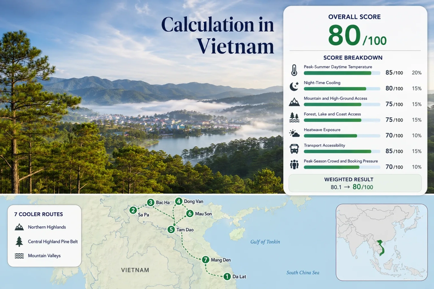
Vietnam’s strongest summer cooling patterns occur well above the hot lowlands. Da Lat and Mang Den rely on elevated pine plateaus, Sa Pa and Bac Ha combine mountain nights with monsoon cloud, while Dong Van, Tam Dao and Mau Son trade straightforward access for sharper altitude, forest or karst-road advantages. July and August remain wet across much of the route set, so lower temperatures must be balanced against fog, intense showers and mountain-road disruption.
The score uses the same Da Lat, Sa Pa, Bac Ha, Dong Van, Tam Dao, Mau Son and Mang Den locations shown on the map.
Every selected base begins near or above Vietnam’s strongest practical hill-station altitude band.
Both retain comparatively restrained daytime temperatures, although Sa Pa carries heavier northern monsoon cloud and trail disruption.
Elevated bases and reduced urban heat storage support the clearest overnight temperature drop in the assessed set.
Air, rail, coach, taxi and organised excursion options reduce dependence on self-driving steep or unfamiliar mountain roads.
Northern passes and Central Highland roads can lose practical comfort when heavy rain reduces visibility or delays transfers.
Pine Plateaus, Northern Valleys and Karst-Road Bases
The marker set separates Vietnam’s two main elevated summer systems: the Central Highland pine belt around Da Lat and Mang Den, and the northern mountain arc extending from Tam Dao through Sa Pa, Bac Ha, Dong Van and Mau Son.
Markers show selected cooler-route regions and approximate planning centres, not guaranteed legal parking areas, trailheads or exact viewpoints. Use the named Google Maps links and current local access information before travelling.
Vietnam Highland Cooler Escape Suitability Score
This transparent editorial suitability index uses disclosed temperature, landscape, access and peak-pressure factors. It is not an official climate classification, live weather product or guarantee of comfortable conditions.
Weighted total: 75×0.25 + 79×0.20 + 100×0.15 + 75×0.15 + 90×0.10 + 80×0.10 + 40×0.05 = 79.8 → 80/100
Method: Route count adds no bonus points. Each route carries equal weight, route-level results are combined with the median, and the seven fixed factors retain the same site-wide weights.
Da Lat Pines, Sapa Valleys and High Northern Roads
The seven bases provide different forms of relief. Some reduce daytime heat, some mainly improve nights, and others work as high-road alternatives only when monsoon visibility and slope conditions remain manageable.
Da Lat: Pine Hills and a High-Altitude City Base
Da Lat offers the most complete car-light highland base in the route set. The city sits near 1,500 m, with a July–August proxy profile of roughly 24.0°C for average daily maxima and 16.5°C for average minima. Pine-covered roads, Tuyen Lam Lake and the Langbiang area provide several ways to move away from built-up streets without committing to a remote multi-day circuit.
July and August fall within the wetter Central Highland season, so the practical pattern is often mild mornings, cloud build-up and afternoon rain rather than dry alpine weather.
Sa Pa: Valley Views, Fansipan Access and Wet-Season Cloud
Sa Pa’s lodging base is around 1,600 m, placing overnight stays inside the high ground rather than below it. The assessed proxy values are about 24.0°C by day and 18.5°C at night, while Fansipan rises to 3,143 m above the town. Rail travel to Lao Cai followed by a road transfer makes Sa Pa one of the easier northern highland bases to reach without self-driving.
Temperature relief does not guarantee trail reliability. July cloud, heavy showers and slippery terrace paths can remove much of the advantage for travellers whose priority is uninterrupted hiking.
Bac Ha: A Quieter Highland Base Beyond the Sa Pa Corridor
Bac Ha is warmer by day than Sa Pa but retains a meaningful elevation advantage over the Lao Cai lowlands. Regular road connections from Lao Cai make the town achievable without a private car, while surrounding highland roads, farms and villages spread visitors more widely than the central Sa Pa corridor.
The weekly rhythm matters more than a conventional peak-season calendar. Sunday market demand changes traffic, room availability and the atmosphere of the town; midweek stays are usually less compressed.
Dong Van Karst Plateau: High Passes With a Road-Condition Trade-Off
The Dong Van base lies around 1,000–1,200 m, with passes climbing substantially higher along the Ha Giang loop. A representative July–August route-centre profile of about 27.0°C by day and 20.0°C at night is milder than the lower approach valleys but less consistently cool than Da Lat or Sa Pa.
Nho Que River access, Ma Pi Leng Pass and the exposed limestone plateau create strong geographic variety, although water and forest access are less immediate from every lodging base. The route is better treated as a multi-stop road circuit than as a relaxed hill-station stay.
Tam Dao: Forest Altitude Close to the Hanoi Region
Tam Dao is the shortest high-ground transition for many Hanoi-based itineraries. The town occupies an elevation near 930–1,000 m beside a protected mountain forest that rises above 1,500 m. The route-centre proxy is warmer than its hill-station image may suggest, at roughly 28.5°C for average daily maxima and 21.5°C for minima in July and August.
The primary gain is elevation, forest cover and reduced nighttime heat storage rather than consistently low daytime temperatures. Weekend traffic and dense development can weaken the sense of escape in the central town area.
Mau Son: Misty Border Ridges and Lower Booking Pressure
Mau Son’s principal highland zone occupies roughly 1,200–1,500 m in Lang Son Province. The proxy profile of about 25.0°C by day and 17.5°C at night creates one of the stronger overnight-cooling results, while forested slopes and exposed ridges can feel noticeably different from Lang Son City below.
Access is road-based and local public transport is limited, but the route carries less routine booking pressure than Sa Pa, Da Lat or Tam Dao. Fog can reduce visibility quickly on the upper road, especially when monsoon cloud sits across the ridge.
Mang Den: Pine Plateau, Lakes and a Developing Highland Base
Mang Den combines a high accommodation base with immediate pine forest, small lakes and waterfall roads. Its July–August temperature profile is close to Da Lat, but the visitor infrastructure is more dispersed and a car or hired driver improves access to surrounding natural areas.
Afternoon rain is a defining Central Highland constraint. Roads can remain usable while outdoor plans become impractical for several hours, making early departures more valuable than tightly packed full-day schedules.
Monsoon Clouds Change the Meaning of Cool in Vietnam
Sa Pa and Dong Van: Cooler Air With Higher Road and Trail Uncertainty
Northwestern and far-northern routes receive substantial summer rain. Sa Pa’s cloud can keep daytime temperatures restrained while obscuring Fansipan and making terrace paths slick. On the Dong Van circuit, the same weather pattern has a more serious transport consequence because steep roads, rock faces and long distances leave fewer practical alternatives.
Da Lat and Mang Den: Mild Mornings Before Afternoon Build-Up
Central Highland rain frequently develops later in the day. Early lake, forest and viewpoint plans can retain their temperature advantage, while late-afternoon waterfall or road itineraries face a higher disruption risk. A two-night stay provides more resilience than a tightly timed single-day stop.
Tam Dao and Mau Son: Ridge Fog Without Alpine Cold
Cloud and wind can make both ridges feel cooler than nearby lowlands, but neither should be treated as reliably cold in July. Tam Dao can remain warm and humid despite its elevation, while Mau Son’s greater exposure and higher lodging zones improve night relief but increase fog-related visibility issues.
Air, Rail and Mountain Roads Divide the Route Set
Da Lat and Sa Pa Without a Self-Drive Mountain Circuit
Da Lat can be reached by air or intercity coach, while Sa Pa is linked to the Lao Cai rail corridor and frequent road transfers. Local taxis, organised excursions and established visitor services allow both to function as highland bases without renting a motorbike.
Bac Ha, Tam Dao and Mang Den With Simple Road Transfers
Bac Ha and Tam Dao require road transfers but do not demand a long multi-day circuit. Mang Den is similarly reachable by road, though its lakes, waterfalls and pine areas are spread widely enough that local vehicle access becomes more important after arrival.
Dong Van and Mau Son Reward Driver-Led Planning
Dong Van has the strongest case for a qualified driver because of distance, bends, weather and repeated pass crossings. Mau Son is a shorter road commitment, but limited local transport and fog on the upper ridge make pre-arranged transfers more reliable than improvised connections.
Which Highland Base Matches the Actual Summer Priority?
Temperature alone does not determine the practical choice. The comparison keeps all seven assessed routes and separates low-heat performance from night relief, transport effort, monsoon exposure and peak-pressure patterns.
| Route | July–August temperature pattern | Night relief | Primary access | Main monsoon trade-off | Peak-pressure pattern |
|---|---|---|---|---|---|
| Da Lat | Low daytime heat for a full-service city base | Strong | Flight or coach; local taxis | Frequent afternoon rain | Weekends and domestic holidays |
| Sa Pa | Low daytime heat with persistent cloud | Moderate to strong | Rail to Lao Cai plus road transfer | Trail rain, fog and slope disruption | Town centre and Fansipan concentration |
| Bac Ha | Warmer days than Sa Pa but elevated nights | Moderate | Road transfer from Lao Cai | Heavy showers on rural roads | Sunday market concentration |
| Dong Van Karst Plateau | Milder than lower Ha Giang valleys, not consistently cool | Moderate | Long driver-led road circuit | Fog, rockfall, runoff and pass visibility | Limited rooms in principal loop towns |
| Tam Dao | Warm-humid days with a hill-station edge | Limited to moderate | Short road transfer from the Hanoi region | Dense fog and intense showers | Sharp weekend surges |
| Mau Son | Restrained ridge temperatures and cooler nights | Strong | Road transfer from Lang Son | Upper-road fog and limited services | Generally lower outside events |
| Mang Den | Low daytime heat across a pine plateau | Strong | Coach or road transfer; vehicle useful locally | Afternoon rain across dispersed attractions | Growing but less concentrated demand |
July–August Timing Across Markets, Passes and Pine Plateaus
Early July: Green Landscapes Before the Heaviest Holiday Pressure
Da Lat and Sa Pa already carry wet-season risk, but accommodation pressure may remain more manageable outside weekends. Bac Ha visitors should still account for the Sunday market, which creates a separate weekly capacity peak.
Late July: Strong Cooling Demand and Higher Disruption Risk
Lowland heat increases demand for Da Lat, Sa Pa and Tam Dao while northern mountain rainfall remains active. Dong Van road plans require additional schedule margin rather than a sequence of fixed arrival times.
August: Retained Highland Relief With Continued Monsoon Exposure
Temperature advantages persist, particularly in Da Lat, Sa Pa, Mau Son and Mang Den. The trade-off remains wet access, reduced long-range views and occasional transport delays rather than a return to stable dry-season conditions.
Before departure: Check current provincial weather warnings, road status, park access, cable-car operation and transport timetables. Heavy rain can change the viability of Dong Van passes, Sa Pa trails, Tam Dao forest access and remote Central Highland roads even when the accommodation base remains comparatively mild.