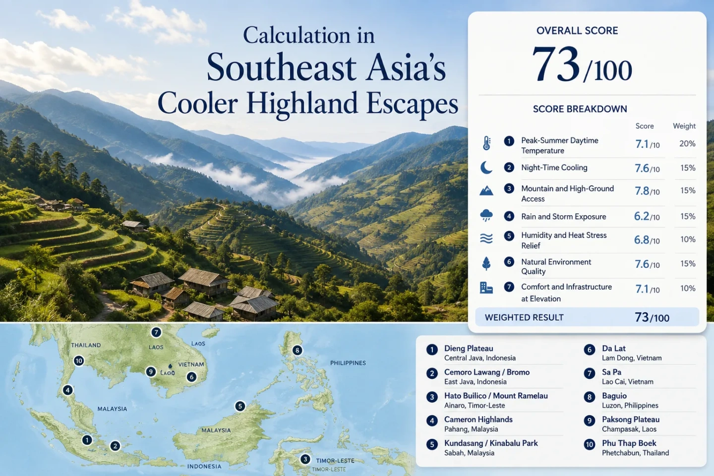
Southeast Asia’s Cooler Highland Escapes
High elevation changes tropical travel most when the accommodation base is high enough to cool both the afternoon and the night. In July and August, Southeast Asia’s uplands divide into very different weather regimes: Java and Timor-Leste combine altitude with a drier season, Malaysia keeps a humid equatorial coolness, while Vietnam, the Philippines, Laos and Thailand trade lower temperatures for monsoon rain, fog or wet-road exposure.
Overnight bases across Indonesia, Timor-Leste, Malaysia, Vietnam, the Philippines, Laos and Thailand.
The route set favors places where the town, village or park base is already on high ground rather than a hot lowland base with a short summit excursion.
July–August altitude is reinforced by clearer nights and lower seasonal rainfall than in the northern monsoon highlands.
Da Lat, Sa Pa, Baguio, Paksong and Phu Thap Boek stay elevation-cooled while rain, cloud or fog becomes part of the trade-off.
Malaysia’s highlands rely more on persistent altitude moderation and cloud than on a sharp dry-season cold spell.
The August–October 2026 ASEAN outlook favors above-normal temperatures across most of the region, with drier conditions more likely across much of southern ASEAN.
From Java’s Dry-Season Plateaus to the Cordillera and Mekong Highlands
The route spread reaches from volcanic plateaus south of the Equator to equatorial cloud-forest bases and monsoon mountain towns farther north. The markers identify planning centers for the ten overnight highland bases.
Markers use approximate public place centers for planning orientation. They are not guaranteed trailheads, viewpoints, legal parking points or navigation pins; local road and park information should be checked before travel.
Highland Bases That Change the July–August Heat Pattern
Elevation alone does not rank these places. The useful distinction is whether a high sleeping base aligns with a drier season, persistent equatorial cloud, or a rain-heavy monsoon.
Dieng Plateau
Dieng places the overnight base at roughly 2,000 metres in Central Java. Indonesia’s tourism authority identifies June through August as a clearer period and notes the possibility of frost. The local bun upas frost forms during very cold dawn conditions and can damage highland crops, so it is more than a novelty for visitors.
The cooling mechanism is unusually favorable for tropical Southeast Asia: high altitude coincides with Java’s drier season, allowing strong overnight heat loss under clearer skies. Sunlit afternoons can still feel much warmer than the pre-dawn hours. Typical road access from Yogyakarta or Semarang takes several hours, so Dieng works more naturally as an overnight plateau stay than a same-day heat escape.
Cemoro Lawang / Bromo
Cemoro Lawang sits in the high village zone above the Tengger caldera, with many visitor facilities above 2,000 metres. Pre-dawn travel to Bromo viewpoints adds open exposure, wind and a further rise in elevation, making sunrise conditions much colder than nearby East Java lowlands.
The trade-off is exposure. Dry weather can mean dust over the volcanic sand, while wind sharply lowers comfort before sunrise. Access can also change because Bromo is an active volcanic system; local restrictions matter even when the weather itself is favorable.
Hato Builico / Mount Ramelau
July and August fall in the drier part of Timor-Leste’s annual cycle, so the high village benefits from both elevation and reduced wet-season cloud compared with the early-year rains. The temperature contrast with Dili is strengthened by the large vertical rise from the north coast into the central mountains.
Access is the limiting factor rather than altitude. Tourism information for Ramelau points to 4WD or motorbike access for the highland approach. That makes Hato Builico one of the more remote choices in the set, but it also lets the night itself happen at elevation instead of returning to a hot coastal base.
Cameron Highlands
At roughly 1,500 metres, Cameron Highlands is a classic equatorial hill-station environment rather than a sharply seasonal cold plateau. Malaysian tourism information commonly describes a 15–25°C temperature range across the year, while nearby Gunung Brinchang reaches 2,032 metres.
Humidity remains part of the experience. Mossy forest and frequent cloud suppress solar heating but do not create the dry, crisp nights found in Java’s high dry season. Tanah Rata and Brinchang also face road congestion during busy weekends, so the climatic advantage can be partly offset by slow mountain-road movement.
Kundasang / Kinabalu Park
Kinabalu Park Headquarters stands at 1,520 metres, about 92 km along the Kota Kinabalu–East Coast Highway. Kundasang and the park area therefore provide a genuine highland sleeping zone, not just a lowland gateway to a mountain.
Morning conditions often offer the clearest contrast: cooler air, a lower sun angle and a better chance of open mountain views before cloud builds around the massif. Rain and cloud remain possible in every month. The altitude advantage is persistent, but the atmosphere is humid and maritime rather than dry-season continental.
Da Lat
Da Lat sits at about 1,475 metres on Vietnam’s Central Highlands. National tourism climate information gives a broad daily average range around 15°C for lows and 24°C for highs, with the rainy season extending through the middle of the year.
Da Lat differs from remote mountain bases because the highland zone is a functioning city with an airport, coaches, restaurants and urban accommodation. Pine-covered slopes and lakes reinforce the cooler setting, but the practical advantage is the ability to remain at elevation for several nights without giving up city services.
Sa Pa
Sa Pa’s high town sits around 1,600 metres in the Hoang Lien Son range. Vietnam tourism information places May through August in the rainy season and describes summer daytime temperatures around 20–25°C. Annual rainfall is roughly 1,800 mm, so the coolness is inseparable from a wet mountain climate.
Fog can erase valley views and rain can make trekking surfaces slick even when air temperature is comfortable. Sa Pa therefore performs very differently from Dieng: both are high, but Sa Pa’s July–August relief arrives inside the northern monsoon rather than a dry-season window.
Access profile: Long-distance road services reach Sa Pa, while rail travelers use Lao Cai and complete the mountain transfer by road.
Baguio
Baguio’s official climate station is at 1,510.08 metres. PAGASA’s 1991–2020 normals show how strongly elevation lowers temperature while the southwest monsoon raises rainfall: July averages a 23.1°C maximum and 16.2°C minimum; August averages 22.3°C and 16.2°C.
Baguio has the services of a large city and regular road links across Luzon, making it easier to use as a multi-night highland base than remote Cordillera towns. Heavy rain, landslide exposure and tropical-cyclone effects remain the central planning constraint in July and August.
Paksong / Bolaven Plateau
Paksong and the Bolaven Plateau sit well above the hot Mekong lowlands of southern Laos. Tourism material places much of the plateau around 1,000–1,350 metres, with volcanic soils and a cooler climate supporting its coffee-growing landscape.
July and August are wet-season months. That raises waterfall volume at sites such as Tad Fane, while also increasing the chance of slick roads, soaked clothing and reduced comfort on motorbike loops. The cooling profile is therefore wet and green rather than dry and cold.
Road access from Pakse is straightforward by regional standards, but weather can change the quality of secondary-road travel more than the map distance suggests.
Phu Thap Boek
Phu Thap Boek reaches 1,768 metres in Phetchabun, placing the overnight mountain zone well above Thailand’s central lowlands. Tourism Authority of Thailand material highlights July and August as part of the mountain’s cabbage-growing season, when wet-season greenery and cloud are prominent.
The same moisture that creates sea-of-clouds conditions can remove distant views and make the road more demanding. Nearby Khao Kho, around 1,174 metres, offers a lower highland alternative, but Phu Thap Boek provides the larger altitude step.
July and August Split the Highlands into Three Weather Regimes
The calendar matters as much as the contour line. A 1,500-metre town north of the Equator can be deep in monsoon weather while a 2,000-metre plateau in Java is in its drier season.
Java and Timor-Leste: Altitude Plus Drier Nights
Dieng, Cemoro Lawang and Hato Builico combine high sleeping bases with the drier part of their annual cycle. Reduced cloud cover allows more overnight heat to escape, so dawn temperatures can fall far below the lowland heat experienced on the approach.
Dieng’s frost episodes and Bromo’s 2026 sub-2°C observation sit at the extreme end of this mechanism. They should not be read as typical daily temperatures, but they show why an equatorial or near-equatorial latitude does not prevent cold dawns on a high, dry-season plateau.
Malaysia: Moderated All Year, Still Humid
Cameron Highlands and the Kundasang–Kinabalu zone do not depend on a single cold-season window. Elevation suppresses daytime heat across the year, while cloud forest, mountain cloud and frequent moisture limit strong solar warming.
The trade-off is humidity. A 20°C evening in damp mountain air can feel very different from a 20°C dry evening at Bromo. Clothing dries more slowly, cloud can build quickly, and a light shower can arrive without the dramatic seasonal shift seen farther north.
Vietnam, the Philippines, Laos and Thailand: Cooler Air Inside the Monsoon
Da Lat, Sa Pa, Baguio, Paksong and Phu Thap Boek all retain altitude relief in July and August, but rain becomes part of the price. Sa Pa can be fog-bound, Baguio can receive rain on most days, Bolaven roads can stay wet, and Phu Thap Boek’s cloud can reduce visibility.
This is not a reason to dismiss them. Waterfalls, cloud seas and green slopes are often at their seasonal peak. It does mean that lower temperature and easier outdoor conditions are separate questions.
Cooling Gain Comes with Different Weather Costs
The same 1,500–2,000 metre altitude band produces different travel conditions because rainfall regime, cloud, wind and road access vary sharply across the region.
| Highland base | Approx. base elevation | July–August regime | Night-cooling character | Rain / fog trade-off | Access pattern |
|---|---|---|---|---|---|
| Dieng Plateau | ≈2,000 m | Java dry season | Strong; frost can occur near dawn | Lower seasonal rain, large day–night swing | Multi-hour road transfer from major Java gateways |
| Cemoro Lawang / Bromo | 2,000 m+ village zone | East Java dry season | Very strong before sunrise | Less rain, but wind and dust can dominate | Road to village; jeep, walking or horse access around the caldera |
| Hato Builico / Mount Ramelau | ≈2,000 m | Drier Timor highland season | Strong at the village and higher on Ramelau | Lower rain burden than the wet season | Highland road; 4WD or motorbike commonly used |
| Cameron Highlands | ≈1,500 m | Equatorial highland | Moderate and persistent | Humid, cloudy and shower-prone | Mountain road by car or bus |
| Kundasang / Kinabalu Park | Park HQ 1,520 m | Equatorial mountain | Moderate to strong in the early hours | Cloud and rain can build around Kinabalu | Road corridor about 92 km from Kota Kinabalu |
| Da Lat | ≈1,475 m | Central Highlands rainy season | Moderate; city stays elevated overnight | Frequent rain and cloud | Airport, coach and city-road access |
| Sa Pa | ≈1,600 m | Northern Vietnam rainy season | Strong relative to the Red River lowlands | High rain, fog and slick trail exposure | Road services; rail via Lao Cai plus road transfer |
| Baguio | 1,510 m station | Philippine southwest monsoon | Strong; normal July–August minima near 16°C | Very high rainfall and frequent rainy days | Major road and bus hub in northern Luzon |
| Paksong / Bolaven Plateau | ≈1,000–1,350 m | Southern Laos wet season | Moderate | High rainfall, strong waterfall flow, wet roads | Road access from Pakse; local loops vary with surface condition |
| Phu Thap Boek | 1,768 m | Thailand rainy season | Strong at night and early morning | Mist, rain and reduced road visibility | Mountain-road access; local vehicle planning matters |
Why Sleeping at 1,500–2,000 Metres Changes the Trip
A high summit visited for two hours does not provide the same heat relief as an overnight base at elevation. Dieng, Hato Builico, Cameron Highlands, Da Lat, Sa Pa and Baguio keep the accommodation zone itself high, so the cooler part of the daily cycle continues through evening and early morning.
This distinction matters in the tropics because the hottest lowland hours can return immediately after descending. A day trip to a high peak can deliver a cold viewpoint and still end with a hot night in the valley. Staying high also captures the hours when clear-sky cooling is strongest at Dieng, Bromo and Ramelau, or when cloud and rain suppress heat at Sa Pa and Baguio.
Dry High Bases
Dieng, Cemoro Lawang and Hato Builico gain the most from the overlap between high sleeping altitude and the drier July–August season. Dawn can require genuinely warm layers even when the lowlands are hot.
Humid High Bases
Cameron Highlands and Kundasang stay moderated without the same dry-night cooling. Damp air, cloud and wet vegetation make the temperature feel softer but can slow drying after rain.
Monsoon High Bases
Da Lat, Sa Pa, Baguio, Paksong and Phu Thap Boek often exchange lowland heat for cloud, rain and wet surfaces. The overnight temperature advantage remains real even when outdoor time needs to fit around showers.
The Same Temperature Can Feel Very Different Across These Highlands
Humidity and Wet Clothing
A 20–22°C evening in Cameron Highlands, Bolaven or Baguio can come with saturated air and damp clothing. Once clothes are wet, evaporative and conductive heat loss can make an otherwise mild temperature feel cold, especially after sunset. Dry clothing and a covered layer matter more here than a single temperature number suggests.
Wind on Bromo and Ramelau
Bromo viewpoints and exposed Ramelau slopes have less shelter than a forested hill town. Wind can dominate pre-dawn comfort even when the measured temperature is not extreme. Open volcanic ground also heats quickly after sunrise, creating a sharp comfort swing within a few hours.
Cloud, Sun Breaks and UV
Cloud can hold afternoon temperatures down in Sa Pa, Kundasang and Phu Thap Boek, then break suddenly. Tropical sun remains strong at altitude, so a cool air temperature does not remove UV exposure or rapid warming on an unshaded slope.
Rooms Built for Tropical Climates
Some highland lodging is lightly insulated and has little or no heating because the wider region is tropical. A room near 15°C can therefore feel colder overnight than the same outdoor temperature in a well-insulated temperate-climate building. Hot water, bedding and room exposure are practical comfort details in Dieng, Bromo and other high bases.
The 2026 El Niño Pattern Changes the Rain Side of the Trade-Off
The ASEAN Specialised Meteorological Centre’s August–October 2026 outlook favors above-normal temperatures across most of ASEAN. It also places much of southern ASEAN under increased odds of below-normal rainfall while El Niño conditions strengthen through the second half of 2026. That combination makes altitude more valuable for heat relief in southern destinations, but it does not guarantee unusually cold highland weather.
For Java, Timor-Leste and parts of the Maritime Continent, a drier-than-normal background can reinforce clear-night cooling while also raising a separate concern: extended dry conditions can increase hotspot and smoke-haze risk. Elevation does not protect a mountain destination from regional smoke transport. In the northern ASEAN sector, monsoon rain remains more variable; Baguio, Sa Pa and other wet-season highlands still require route-specific forecasts rather than a regional rainfall assumption.