Thailand Highland Alternatives: Northern Peaks, Forest Parks and Cooler Mornings
Thailand’s July–August uplands provide relative heat relief rather than alpine cold. The most useful differences come from elevated overnight bases, early departures, forest shade and cloud-covered ridge roads. Lower valleys around Chom Thong, Chiang Dao, Pai, Mae Chan and Pua can still feel warm and humid after sunset, so altitude, monsoon access and the location of the accommodation base must be considered together.
How the Highland Route Set Changes Summer Conditions
Seven routes connect Chiang Mai and Mae Hong Son mountain country with Chiang Rai, Nan, Loei and Phetchabun uplands. They range from warm valley towns with rapid high-ground access to elevated districts where the overnight base itself provides more morning relief.
The same places are used in the map, score, route cards and comparison table.
A monsoon-season window with frequent cloud, wet roads and short clear-weather intervals.
About 26.7°C for the July–August average daily high in the disclosed long-term profile.
Their accommodation areas sit closer to the high ground than the warmer northern valley gateways.
Shade and elevation reduce daytime intensity, while humidity limits night-time cooling.
Fog, runoff, intense showers and local slope failures can change journey times quickly.
Northern Ranges and the Phetchabun–Loei Uplands
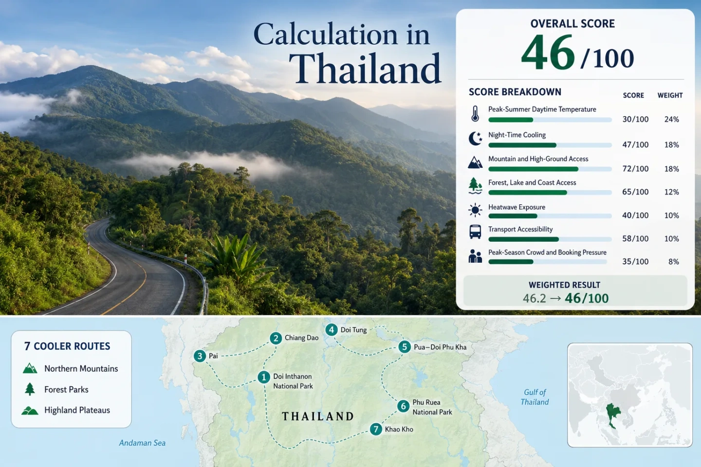
The markers show practical route centers across Thailand’s northern and north-central highlands. They are planning references, not exact viewpoints, trailheads or legal parking positions.
Marker positions use approximate public location centers. Use the Google Maps link and access note in each route card before travelling, especially where park gates, campsites or viewpoints may change with weather.
Thailand Highland Alternatives Suitability Score
This transparent editorial index applies the same seven factors and weights used across Cooler Escapes. It assesses the displayed route set rather than Thailand as a whole and is not an official climate classification or a weather forecast.
Interpretation: High-ground and forest access are strong, but warm wet-season nights, frequent 30°C exposure at lower bases and vehicle-dependent park transfers keep the total moderate.
The seven route scores are equally weighted within each factor. Route count does not add a bonus.
Peaks, Forest Roads and Elevated Overnight Bases
The decisive distinction is whether altitude is reached only for a daytime excursion or retained at the accommodation base. Temperatures shown are disclosed route-base proxies, not guaranteed summit conditions.
Doi Inthanon National Park
Doi Inthanon creates the largest single-day altitude contrast in the set. The summit road reaches Thailand’s highest point, but the conservative Chom Thong base proxy averages about 32.8°C by day and 26.1°C at night in July–August. An upper-slope stay is therefore materially different from sleeping in the low gateway.
Wachirathan and Mae Ya waterfalls can carry strong wet-season flow, while cloud can erase summit views. Early departure, flexible stop order and current road checks are more useful than a panorama-dependent schedule.
Chiang Dao
Chiang Dao combines a practical town with immediate access to a 2,000 m-class limestone massif. The base profile averages about 29.7°C by day and 23.9°C at night, providing less daytime heat than many plains locations but limited overnight cooling by temperate standards.
Doi Luang Chiang Dao trekking is regulated and seasonal. During the monsoon window, caves, foothill forest, village roads and mountain-view stays are more dependable than assuming summit access.
Pai
Pai offers the easiest multi-night town rhythm in the northern group. The July–August profile averages about 28.9°C by day and 22.8°C at night. Morning mist and green valley landscapes reduce visual heat, though humidity remains substantial.
The winding Chiang Mai road is the principal trade-off. Regular services simplify arrival, but motion sensitivity, wet pavement and shower-related delays can shape the travel day.
Doi Tung
Doi Tung works as a ridge-road circuit from Chiang Rai or Mae Chan. The conservative Mae Chan base profile averages about 30.3°C for July–August highs and 23.9°C for lows. Climbing onto the ridge improves shade, cloud and airflow without requiring a long trek.
The Royal Villa, Mae Fah Luang Garden and reforested slopes provide structured stops. Low cloud can hide distant views, so the route retains value through its forest environment and managed facilities.
Pua–Doi Phu Kha
Pua is the practical service base for the Doi Phu Kha road, but its July–August profile remains warm at about 30.8°C by day and 24.4°C at night. The cooling value appears after climbing into the forested national park rather than in the agricultural basin.
Lower visitor pressure is balanced by fewer transport options. Fuel, daylight, rain intensity and road updates deserve more attention than a dense sequence of stops.
Phu Ruea National Park
Phu Ruea is a stronger wet-season alternative because the district profile averages about 27.8°C by day and 21.4°C at night. The plateau’s pine fields, forest edge and road-access campsite keep the overnight base closer to the high ground.
Fog and wet pavement can limit sunrise and viewpoint plans, but the route does not depend on a long summit trek. July–August is greener and generally less pressured than the cold-season period.
Khao Kho
Khao Kho has the lowest route-base proxy in the set: about 26.7°C for July–August highs and 20.6°C for lows. Muggy conditions remain possible, but the district provides the clearest combination of lower daytime heat and cooler mornings without relying on a brief summit visit.
Accommodation is dispersed across ridges, valleys and temple-view corridors. A car simplifies movement, while cloud can remove long views without removing the upland temperature advantage.
Seven Routes Compared by Overnight Base and Access
The temperature column refers to the disclosed July–August route-base profile rather than a summit measurement. High-air access describes how readily the route moves from that base into higher terrain.
| Route | Base High / Low | High-Air Access | Monsoon Trade-Off | Without a Car |
|---|---|---|---|---|
| Doi Inthanon National Park | 32.8°C / 26.1°C | Very strong; paved road to 2,565 m | Fog, runoff and changing waterfall conditions | Arranged tour is practical; independent park movement is difficult |
| Chiang Dao | 29.7°C / 23.9°C | Strong mountain setting; summit access regulated | Wet limestone terrain and trail restrictions | Town reachable; local transfers needed |
| Pai | 28.9°C / 22.8°C | Moderate; mountain roads around a valley base | Winding wet-road approach and heavy showers | Strongest town-based option in the set |
| Doi Tung | 30.3°C / 23.9°C | Strong ridge-road access | Low cloud can remove distant views | Gateway access works; ridge circuit favors a car |
| Pua–Doi Phu Kha | 30.8°C / 24.4°C | Strong after leaving the warm Pua basin | Long wet park road and limited services | Weak for independent car-free travel |
| Phu Ruea National Park | 27.8°C / 21.4°C | Strong; plateau and campsite reached by road | Fog, slick pavement and uncertain sunrise views | Intercity arrival possible; local vehicle useful |
| Khao Kho | 26.7°C / 20.6°C | Strong; accommodation already distributed in uplands | Cloud can hide ridge panoramas | Dispersed layout strongly favors a car |
Why Monsoon Altitude Does Not Behave Like a Dry Mountain Summer
Cloud Can Reduce Solar Load
On Doi Inthanon, Doi Tung and Doi Phu Kha, dense cloud and forest shade can make a midday stop feel markedly less harsh than a lowland city. The trade-off is reduced visibility and a higher chance that a scenic road becomes a slow-weather route.
Humidity Limits Night Relief
Pai, Chiang Dao, Mae Chan and Pua remain tropical valley bases. Even when daytime highs are moderated, mean lows around 23–24°C can leave rooms feeling warm unless ventilation or air-conditioning is adequate.
Rain Intensity Matters More Than Monthly Totals
A monthly rainfall figure does not show whether a travel day contains light showers or a short intense downpour. Mountain roads, waterfall access and slope stability should be checked close to departure rather than inferred from a monthly average.
Summit Excursion or Elevated Overnight Base
Large Daytime Climbs from Warm Gateways
Doi Inthanon, Doi Tung and Doi Phu Kha create substantial altitude gain after leaving Chom Thong, Mae Chan or Pua. They suit travellers who accept a warm overnight base in exchange for a cooler forest-road day.
Operational advantage: More accommodation and services remain available in the gateway town.
Highland Districts That Retain Morning Relief
Khao Kho and Phu Ruea keep accommodation closer to the plateau climate. They are more convincing choices when sleep temperature and early-morning comfort matter more than reaching Thailand’s highest summit.
Operational trade-off: Lodging and viewpoints are dispersed, so local mobility is weaker without a car.
July–August Timing for Northern Parks and Ridge Roads
Early July
Green landscapes and active waterfalls are established, while some routes may receive shorter rain interruptions than later in the monsoon. Road conditions still require daily checks.
Late July
Cloud and soil saturation become more important. Weekend demand can cluster around short clear periods at Doi Inthanon, Pai and Khao Kho.
August
Rainfall and low cloud commonly become a larger operational constraint. Elevated bases remain useful, but long mountain-road transfers need more daylight margin.