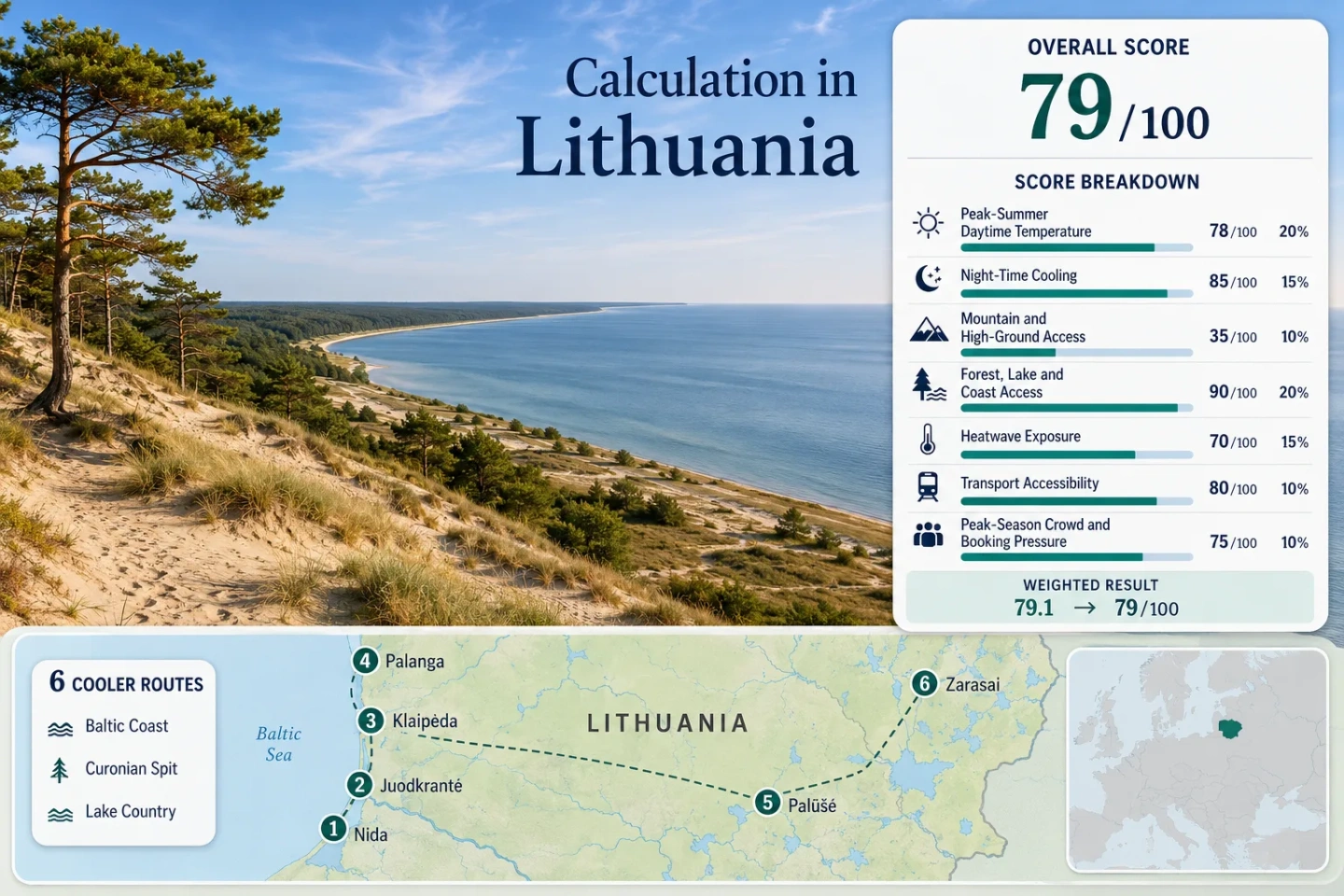
Lithuania in mild summer showcases Curonian Dunes, Baltic air, and scenic lake country for a relaxing outdoor experience.

Lithuania in Mild Summer Mode: Curonian Dunes, Baltic Air and Lake Country

Lithuania’s mild-summer case rests on two different systems: a Baltic coast where maritime air reduces daytime peaks, and an eastern lake belt where pine forest, open water and cooler nights provide relief after warmer afternoons. Nida, Juodkrantė, Klaipėda and Palanga form the coastal side of the route set; Palūšė and Zarasai add a more continental lake-country contrast.

Routes Assessed
6 bases

Four Baltic and Curonian locations are balanced by two eastern lake-country bases.

Coastal Thermal Lag
August matters

Official climate material places the coastal temperature peak later than inland Lithuania.

Lowest-Heat Pair
Nida + Juodkrantė

Baltic exposure, lagoon proximity and forested dunes combine within a very narrow land strip.

Car-Light Anchors
Klaipėda + Ignalina

Rail reaches Klaipėda directly and places Palūšė within a short final connection from Ignalina.

Altitude Ceiling
About 5–155 m

The route set has no true high-altitude refuge; water, forest and latitude do the cooling work.

Main Access Hinge
Smiltynė ferry

Curonian Spit timing changes with passenger-versus-vehicle crossings, queues and the Neringa local fee.

From the Curonian Spit to Aukštaitija’s Lakes

The marker sequence follows the same six places used by the suitability score, route portfolio and comparison matrix.

Markers show selected cooler-route regions and planning centers, not guaranteed legal parking, trailheads or exact viewpoints. Route cards carry location links and access context for final checks.

Lithuania Baltic and Lake-Country Cooler Escape Suitability Score

This transparent editorial suitability index uses disclosed climate, landscape, access and pressure factors. It is not an official climate classification or a weather forecast.

79 out of 100
Calculated from 7 disclosed factors
Target windowJuly–August
Climate baseline1981–2010 route proxies; 1991–2020 national context
Heatwave period1981–2010 official threshold-frequency fallback
Routes assessed6 routes
MethodologyVersion 1.2
Last reviewedJuly 18, 2026
Factor coverage7/7
Comparability qualityC — rounded atlas readings, representative stations and a threshold-frequency proxy
Peak-Summer Daytime Temperature 25%
100/100
Method: Representative Station aggregation using July–August average-maximum values rounded to the nearest 0.5°C from the official atlas chart. Raw: 19.5°C route median. Route values: Nida 19.5°C; Juodkrantė 19.5°C; Klaipėda 19.5°C; Palanga 19.5°C; Palūšė 21.0°C; Zarasai 21.0°C. Median: 19.5°C. Source mapping: Nida — Klaipėda representative station, about 47 km north, comparable near-sea-level maritime setting; Juodkrantė — Klaipėda representative station, about 20 km north, similar low elevation; Klaipėda — direct station; Palanga — Klaipėda representative station, about 25 km south, similar coastal elevation; Palūšė — Utena representative station, about 36 km southwest and roughly 50 m lower; Zarasai — Utena representative station, about 50 km southwest and roughly 25 m lower. Station codes are not published in the cited atlas chart. Period: 1981–2010 station normals shown in the official climate atlas; the current national standard-normal context is 1991–2020. Sources: Lithuanian Hydrometeorological Service climate atlas; Lithuanian standard climate normals
Night-Time Cooling 20%
100/100
Method: Representative Station aggregation using July–August average-minimum values rounded to the nearest 0.5°C from the same official atlas chart. Raw: 13.5°C route median, inside the 10–16°C full-score band. Route values: Nida 13.5°C; Juodkrantė 13.5°C; Klaipėda 13.5°C; Palanga 13.5°C; Palūšė 12.5°C; Zarasai 12.5°C. Median: 13.5°C. Source mapping: Nida — Klaipėda representative station, about 47 km north with a comparable near-sea-level maritime setting; Juodkrantė — Klaipėda representative station, about 20 km north and at similar elevation; Klaipėda — direct station; Palanga — Klaipėda representative station, about 25 km south and at similar elevation; Palūšė — Utena representative station, about 36 km southwest and roughly 50 m lower; Zarasai — Utena representative station, about 50 km southwest and roughly 25 m lower. Station codes are not published in the cited atlas chart. Period: 1981–2010 station normals, July–August route window. Sources: Official monthly maximum and minimum temperature charts
Mountain and High-Ground Access 15%
0/100
Method: Fixed categorical rubric applied to route-base elevation and meaningful high-ground access within 60 minutes. Raw: Route median 0/100. Route scores: Nida 0 — dune relief remains far below the 300 m threshold; Juodkrantė 0 — forested dunes do not meet the rubric; Klaipėda 0 — low coastal city with no qualifying high ground; Palanga 0 — low coastal resort with no qualifying high ground; Palūšė 0 — approximately 155 m base and no 1,000 m terrain; Zarasai 0 — approximately 132 m base and no 1,000 m terrain. Median: 0/100. Route rationale: Curonian dune ridges create wind exposure and local relief, while Aukštaitija has moraine hills, but neither system functions as mountain or high-ground access under the site-wide thresholds. Period: Access and terrain status reviewed July 18, 2026. Sources: Curonian Spit National Park terrain; Aukštaitija National Park terrain
Forest, Lake and Coast Access 15%
100/100
Method: Fixed categorical access rubric measuring strong water and forest elements within 30 minutes. Raw: Route median 100/100. Route scores: Nida 100 — Baltic coast, Curonian Lagoon and pine forest; Juodkrantė 100 — lagoon, forested parabolic dunes and nearby Baltic shore; Klaipėda 100 — Baltic shoreline and Curonian Lagoon gateway; Palanga 75 — immediate Baltic coast as one dominant element; Palūšė 100 — lake network and extensive national-park forest; Zarasai 100 — dense lake access with surrounding woodland. Median: 100/100. Route rationale: The score measures physical access rather than scenic quality. The Curonian Spit places sea, lagoon and forest on one narrow peninsula, while the eastern routes sit inside lake-and-forest systems. Period: Public access context reviewed July 18, 2026. Sources: Curonian Spit protected-area profile; Aukštaitija lake and forest profile; Zarasai tourism information center
Heatwave Exposure 10%
94/100
Method: Official threshold-frequency fallback. No exact latest-ten-summer daily extraction is claimed. The official annual +30°C frequency bands are converted conservatively to a 62-day July–August window. Raw: 1.6% route median, normalized by linear interpolation between the 1% and 2% thresholds. Route values: Nida 1.6% — one climatological +30°C day divided by 62; Juodkrantė 1.6%; Klaipėda 1.6%; Palanga 1.6%; Palūšė 4.8% — three days divided by 62; Zarasai 6.5% — four days divided by 62. Median: 1.6%. Source mapping: Nida, Juodkrantė, Klaipėda and Palanga — official atlas coastal regional band, with the conservative upper value of one +30°C day per year; station code is not applicable to this regional fallback. Palūšė — official eastern-inland frequency context converted to three days per year; Zarasai — the same regional context converted to four days per year because the official national maximum record is located there. These are regional threshold-frequency proxies, not station daily-count coverage claims. Period: 1981–2010 official climatological frequency material; current warming context checked against the service’s climate-index and 2024 summer summaries. Sources: Official +30°C frequency charts and regional text; Official climate indices; Official 2024 summer assessment
Transport Accessibility 10%
70/100
Method: Fixed categorical transport rubric using current rail, coach, ferry and final-connection requirements. Raw: Route median 70/100, calculated from the middle pair of 60 and 80. Route scores: Nida 60 — rail or coach to Klaipėda, ferry and onward bus or car; Juodkrantė 60 — the same ferry hinge with a shorter peninsula transfer; Klaipėda 100 — direct intercity rail and bus access with no private car required; Palanga 80 — frequent coach access from Klaipėda and other hubs, but no direct rail station; Palūšė 80 — daily rail to Ignalina plus a short final local connection; Zarasai 60 — regular intercity bus access but no rail and more car dependence for dispersed lakes. Median: 70/100. Route rationale: Ferry frequency is strong, yet a peninsula transfer remains an extra step. The lake-country split is sharper: Palūšė benefits from the Vilnius–Ignalina rail corridor, while Zarasai relies on buses and local road travel. Period: Timetables and station availability reviewed July 18, 2026. Sources: Smiltynė ferry timetable; LTG Link timetables; LTG Link station list
Peak-Season Crowd and Booking Pressure 5%
50/100
Method: Fixed categorical fallback using official ferry capacity, access fees, protected-area restrictions and municipal accommodation-pressure evidence. Raw: Route median 50/100, calculated from the middle pair of 40 and 60. Route scores: Nida 40 — ferry, local fee, parking limits and concentrated summer lodging demand; Juodkrantė 40 — the same peninsula bottleneck with less accommodation depth than Klaipėda; Klaipėda 60 — major summer gateway pressure but broader urban capacity; Palanga 20 — recurring peak-resort occupancy and dense weekend demand; Palūšė 80 — localized campsite and lakeshore pressure without a broad reservation bottleneck; Zarasai 80 — event-weekend pressure can occur, but capacity restrictions are not widespread across the route base. Median: 50/100. Route rationale: The strongest constraints are concentrated on the Curonian Spit and in Palanga. Eastern lake-country demand is more dispersed, though small campsites and waterfront stays can still fill around warm weekends. Period: Current access systems reviewed July 18, 2026; official municipal occupancy evidence is used as categorical context rather than a uniform six-route percentage. Sources: Neringa local fee; Official ferry capacity schedule; Curonian Spit visitor restrictions; Palanga municipality occupancy context; Official accommodation-data catalog

Weighted total: 100×0.25 + 100×0.20 + 0×0.15 + 100×0.15 + 94×0.10 + 70×0.10 + 50×0.05 = 78.9 → 79/100

Method: Route count adds no bonus. Each factor is calculated from route-level values or fixed rubric scores, the six-route median is normalized, and the site-wide weights are then applied.

Read the Cooler Escape scoring methodology

Curonian Settlements, Baltic Bases and Eastern Lake Towns

Each base solves a different summer problem: Nida and Juodkrantė maximize the narrow-spit effect, Klaipėda simplifies transport, Palanga keeps full resort services close to the sea, and the eastern pair trades maritime moderation for cooler nights and direct lake access.

1

Nida Between the Baltic and Curonian Lagoon

Rounded July–August proxy: About 19.5°C average maximum and 13.5°C average minimum, using Klaipėda as a representative maritime station.

Nida sits at roughly 5 m above sea level, yet its thermal advantage comes from exposure rather than altitude. Baltic air reaches the western beach, lagoon breezes influence the eastern edge, and pine forest covers much of the intervening dune landscape.

Sea + lagoon Ferry-dependent Low night heat
Main caution: Vehicle access adds a ferry crossing, Neringa’s local fee and limited parking; passenger-ferry and bus combinations reduce that friction.

Nida on Google Maps

2

Juodkrantė’s Forested Dunes and Shorter Peninsula Transfer

The practical gain is distance: Juodkrantė lies closer to the Klaipėda ferry than Nida, while still placing the lagoon, ancient parabolic dunes and Baltic shore within one compact landscape.

The climate proxy remains about 19.5°C by day and 13.5°C at night for July–August. Klaipėda station is approximately 20 km north and provides the representative low-elevation maritime record.

Why it stands out: The shorter transfer preserves Curonian Spit air and forest access without committing to the peninsula’s longest road segment.

Juodkrantė on Google Maps

3

Klaipėda as the Rail-and-Ferry Cooling Base

Transport first: Klaipėda is the only route in the set with direct intercity rail, a full urban bus network and immediate access to both Smiltynė ferry terminals. A private car is optional for city-and-coast days.

Direct climate station About 19.5°C max proxy About 13.5°C min proxy

The city is less secluded than the Curonian settlements, but it gives the widest fallback range when wind, rain or ferry timing changes. The current published new-terminal schedule includes frequent daytime vehicle crossings, while the old terminal serves the passenger-focused city-center connection.

Klaipėda on Google Maps

4

Palanga’s Open Baltic Shore With Peak-Resort Pressure

Palanga keeps the coast inside a service-rich town rather than behind a ferry. Klaipėda, about 25 km south, supplies the representative climate evidence: roughly 19.5°C average maximum and 13.5°C average minimum across July–August.

Its base is close to sea level, high ground is absent, and the main temperature control is onshore Baltic air. That makes beach proximity decisive: inland streets can feel warmer during calm sunny periods than the exposed shoreline.

Coach access No direct rail
Watch for: Warm weekends can create the route set’s strongest accommodation and promenade pressure.

Palanga on Google Maps

5

Palūšė for Lake Access and Cooler Inland Nights

Night relief is the stronger argument here. Utena’s representative July–August chart gives about 21.0°C for average maximum and 12.5°C for average minimum, with Palūšė roughly 36 km northeast and about 50 m higher.

The village sits near 155 m and opens directly onto the Aukštaitija lake-and-forest network. Daily trains reach Ignalina from Vilnius; the final connection to Palūšė is short enough for a local bus, taxi or bicycle plan.

Rail via Ignalina Lake + forest Cooler minimum proxy

Palūšė on Google Maps

6

Zarasai’s Lake Network With a Larger Inland Heat Range

Zarasai combines a roughly 132 m town base with immediate access to multiple lakes, but its eastern continental position raises the chance of hotter afternoon spikes. The representative Utena proxy is about 21.0°C by day and 12.5°C at night.

Trade-off: The threshold-frequency proxy reaches 6.5% for +30°C days in the July–August window, while nighttime relief remains stronger than on many warmer European lake routes.

Intercity buses reach the town, yet dispersed beaches, regional parks and smaller lakes are easier with a car. This is the route for broad lake choice rather than the simplest car-free itinerary.

Intercity bus Car useful locally About 50 km from Utena proxy

Zarasai on Google Maps

Why the Baltic Coast Peaks Later Than Inland Lithuania

Klaipėda’s Narrower Summer Temperature Range

The official climate atlas describes the sea’s strongest influence in a narrow coastal belt. Summer maximums rise less sharply than inland, while nighttime minimums remain comparatively steady. That produces milder afternoons without requiring mountain elevation.

The Lagoon Can Warm Nida’s Eastern Edge in August

The same atlas notes that the eastern Curonian Spit can become Lithuania’s warmest August zone when the shallow lagoon stores heat. Beach-side wind exposure and lagoon-side shelter are not thermally identical, even within the same settlement.

Eastern Lakes Cool More Clearly After Sunset

Palūšė and Zarasai lose the Baltic’s daytime moderation but gain a lower representative minimum of about 12.5°C. The practical pattern is warmer lake afternoons followed by a more noticeable evening drop.

How the Klaipėda Ferry Changes Curonian Spit Planning

Passenger Crossings Favor a Car-Light Day

The old ferry terminal links central Klaipėda with Smiltynė for passengers and bicycles. That pattern works well for forest, beach and museum access near the northern spit, while Nida and Juodkrantė still require onward public transport.

Vehicle Crossings Add Capacity and Fee Decisions

The new terminal carries vehicles, and published daytime departures are frequent. The extra variables are queue time, Neringa’s local entry fee, parking restrictions and the long single-road continuation toward Nida. Early crossing time matters more than raw road distance on busy summer weekends.

Operational check: Ferry schedules, temporary traffic changes and local-fee rates can change; verify all three before committing to a vehicle-based peninsula day.

Ignalina Rail, Palūšė Shores and Zarasai’s Road Spread

Vilnius–Ignalina Rail Creates the Eastern Car-Light Option

LTG Link’s Vilnius–Ignalina–Turmantas corridor reaches the lake district directly. Palūšė then needs only a short final connection, making it the stronger inland route for travelers who do not want to rent a car.

Palūšė Concentrates Water and Forest Near the Base

National-park lake systems, pine forest and paddling access begin close to the village. A short local radius is enough for a full day, which reduces heat exposure from long road transfers.

Zarasai Rewards a Wider Driving Radius

The town itself has immediate lake access, but the broader district’s beaches, campgrounds and regional-park landscapes are dispersed. A vehicle increases choice during a hot spell because the day can shift between exposed waterfronts and shaded smaller lakes.

Six Routes Compared by Heat Pattern, Access and Pressure

The matrix keeps the full route set intact and separates daytime moderation from night relief, transport simplicity and peak-season friction.

RouteThermal signatureNight reliefCar-light setupPeak pressureMain trade-off
NidaStrong maritime moderationAbout 13.5°C proxy minimumPossible, but ferry plus onward busHighLongest peninsula transfer and local fee
JuodkrantėMaritime air with dense forest coverAbout 13.5°C proxy minimumPossible with ferry and busHighSmaller lodging base and ferry dependency
KlaipėdaCoastal moderation with urban heat pocketsAbout 13.5°C direct-station proxyStrongest in the setModerateLess immediate nature than the spit
PalangaOpen-coast relief near the beachAbout 13.5°C proxy minimumGood by coachVery highResort crowds and no direct rail
PalūšėWarmer afternoons, cooler inland nightsAbout 12.5°C proxy minimumGood via Ignalina railLowerShort final connection still required
ZarasaiLargest inland heat-spike rangeAbout 12.5°C proxy minimumModerate by intercity busLowerCar useful for the dispersed lake network

Three Summer Windows for Dunes, Swimming and Quieter Lakes

Late June for Long Light and Lower Capacity Pressure

Daylight is near its annual maximum, Baltic and lake water remain cooler, and the main resort surge is not yet fully established. Hiking, cycling and mixed city-nature days generally fit this period better than swimming-led plans.

July to Mid-August for Water Use With Booking Friction

This is the most practical swimming and paddling window, but it also concentrates Palanga demand, Curonian ferry traffic and Nida accommodation pressure. Coastal heat risk remains lower than inland, while Zarasai needs a clear hot-day fallback.

Late August to Early September for Baltic Thermal Lag

The sea and lagoon retain summer warmth after inland nights begin to cool. The trade-off is shorter daylight and gradually reduced seasonal service. Nida and Klaipėda gain relative value when swimming remains possible but peak-family traffic eases.

Final live checks: Use the Lithuanian Hydrometeorological Service forecast, LTG Link traffic notices, Smiltynė ferry schedule and protected-area access rules for the actual travel dates.
📌

Complete guide: Europe