Latvia for Baltic Cooldowns: Pine Coasts, Forest Towns and Long Summer Evenings
Latvia’s summer-cooling strength comes from its exposed Baltic shoreline, dune pinewoods, lake towns and shaded Gauja Valley bases rather than substantial mountain elevation. The open western coast provides the clearest daytime temperature advantage, while Alūksne adds lower night temperatures and Jūrmala, Sigulda and Cēsis provide easier rail-based alternatives. Long daylight supports late walks and beach time, although short warm spells, rain shifts and peak-weekend accommodation pressure still require flexible planning.
Three open-coast bases, one Gulf of Riga pine belt, two Gauja Valley towns and one eastern lake town.
Kolka, Ventspils and Liepāja receive stronger maritime moderation than sheltered inland valleys during many summer afternoons.
These bases sit on scheduled passenger rail lines, reducing dependence on a rental car for the main arrival journey.
Daylight approaches eighteen hours near the June solstice at Latvian latitudes and remains extended through much of July.
The town stands at roughly 217 metres, modest globally but meaningful within Latvia’s predominantly low-relief landscape.
Kolka and the Slītere coast require closer timetable checks than rail-linked Jūrmala, Sigulda or Cēsis.
From Liepāja’s Open Baltic Shore to Alūksne’s Lake Upland
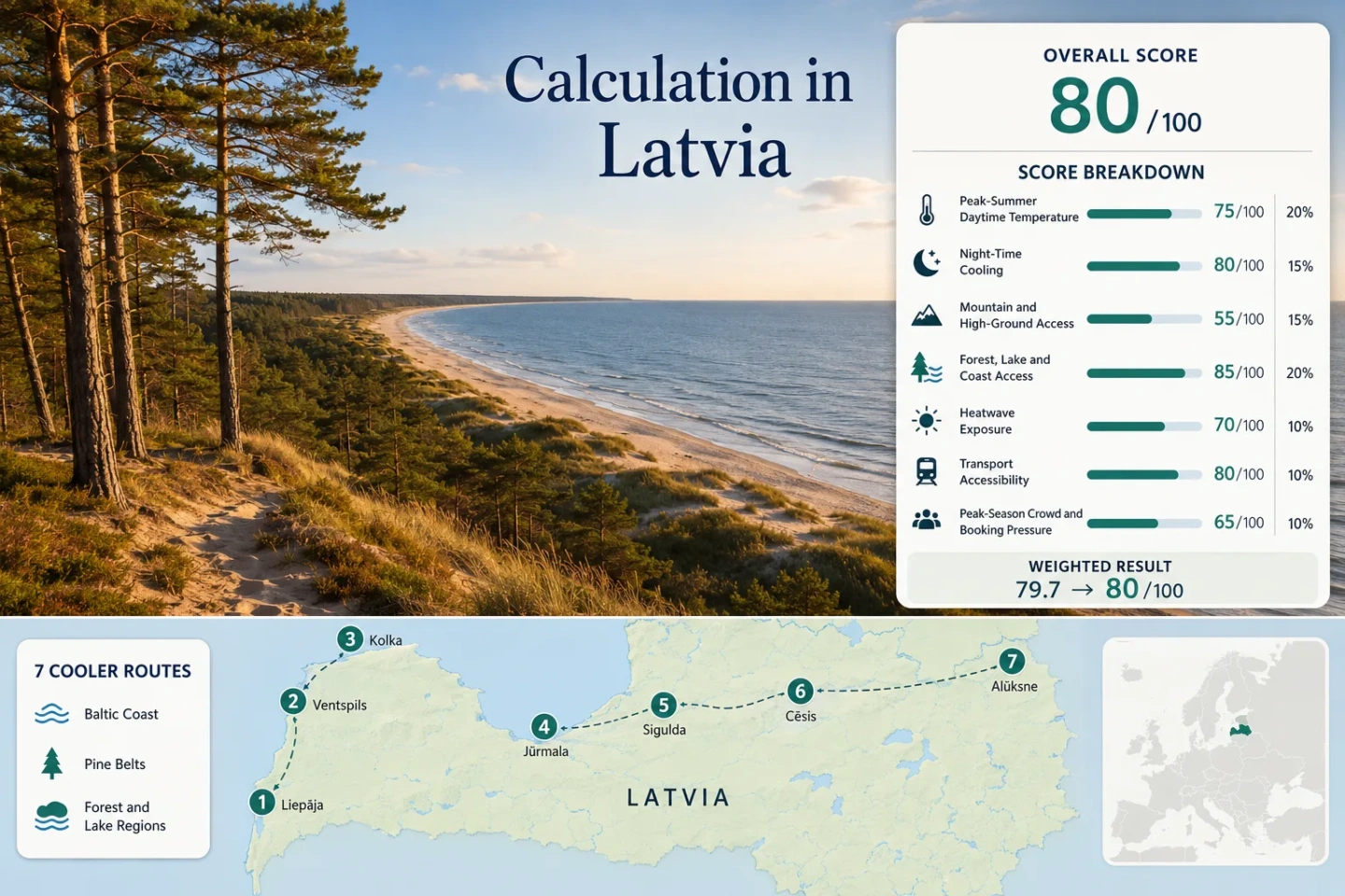
The route set crosses three distinct cooling systems: the exposed western seaboard, the forested Gauja corridor and the higher lake country of north-eastern Latvia.
Markers show selected cooler-route regions and planning centres, not guaranteed legal parking, trailheads or exact viewpoints. Use the named Google Maps links and current local access information before travelling.
Latvia Baltic and Forest Route Suitability Score
This transparent editorial suitability index uses disclosed climate, landscape, access and pressure factors for the seven mapped routes. It is not an official climate classification or a weather forecast.
Weighted total: 98×0.25 + 100×0.20 + 0×0.15 + 100×0.15 + 99×0.10 + 80×0.10 + 60×0.05 = 80.4 → 80/100
Method: Route count does not add bonus points. Every route carries equal weight, route-level values are combined using the median and the seven fixed factor weights are then applied.
Baltic Shores, Gauja Forests and the Alūksne Upland
Each base offers a different trade-off between maritime moderation, night cooling, rail access and service density. The temperature figures are July–August historical climatology values used in the score rather than live forecasts.
Liepāja and the South Kurzeme Pine Coast
Open-sea exposure is Liepāja’s main advantage. Its July–August route-centre climatology is approximately 21.2°C for daytime maxima and 14.4°C for night minima, with a 30°C-or-higher fallback frequency near 0.8% of the target window.
Central beaches, the seaside park and Karosta’s Beberliņi area allow quick movement between urban services, sand, pine shade and an inland water body. The city is nearly flat, so cooling depends on wind direction and sea influence rather than elevation.
Ventspils Dunes and the North Kurzeme Shore
Ventspils records one of the cooler route profiles in the set: about 20.8°C for July–August average maxima, 14.3°C for average minima and roughly 0.6% for the official 30°C threshold-frequency fallback.
The dune promenade, pine-backed beach and compact urban layout support short, low-effort transitions from accommodation to the coast. Regular intercity coaches provide direct access, although there is no current passenger-rail service to the city.
Kolka and the Slītere Coast
At Cape Kolka, the open Baltic Sea meets the Gulf of Riga. The route has the lowest estimated daytime maximum in the portfolio at about 20.4°C, a 14.5°C average minimum and a 30°C threshold-frequency fallback near 0.3%.
Slītere’s cooling environment combines sandy shore, dry dune pinewoods, wet forests and the park’s distinctive dune-ridge and hollow system. The ancient Baltic Ice Lake shore rises roughly 30–50 metres, creating local relief without qualifying as high-ground access under the score rubric.
Jūrmala and the Ķemeri Pine Belt
The strongest advantage is access rather than the lowest temperature. Frequent trains connect Riga with Jūrmala districts and Ķemeri, while the route combines Gulf beaches, dry pinewoods, wetlands, lakes and bog landscapes.
The July–August climate values used here are approximately 22.2°C by day and 14.7°C at night. The 30°C threshold-frequency fallback is about 1.8%, higher than the open Kurzeme coast but still low within the scoring framework.
Ķemeri National Park covers 36,184 hectares, so the route can shift from resort streets to wet forest and bog environments without a long cross-country transfer.
Sigulda and the Shaded Gauja Valley
Direct trains, a compact centre and immediate access to the Gauja Valley make Sigulda the simplest car-light forest base in the route set. July–August values are approximately 22.6°C for average maxima and 13.2°C for minima.
Daytime temperatures can run warmer than the exposed Baltic coast, and the 30°C fallback frequency is approximately 2.7%. Comfort therefore depends on using forested paths, valley shade and early or late walking hours rather than expecting mountain conditions.
Cēsis and the Central Gauja Forests
Cēsis adds a historic, walkable town base to the central Gauja landscape. The route uses approximately 22.2°C for July–August average maxima, 12.8°C for minima and a 30°C threshold-frequency fallback near 2.3%.
The representative Priekuļi climate area lies close to Cēsis and reflects the slightly higher, cooler-night character of central Vidzeme. Direct rail reaches the town, while many river cliffs, forest paths and Amata-area sites require onward local transport, cycling or a car.
Alūksne Lake District and East Vidzeme Upland
Alūksne sits at approximately 217 metres, while Lake Alūksne covers about 15.7 square kilometres and lies at roughly 183.7 metres above sea level. Those figures make it Latvia’s clearest combination of a higher town base and immediate large-lake access.
The route’s July–August values are approximately 21.5°C by day and 12.2°C at night. Its 30°C threshold-frequency fallback is about 1.1%, and the lower average minimum gives Alūksne the strongest night-cooling profile in the set.
Which Latvian Base Fits Each Cooling Priority
The same seven mapped routes are compared using the decisions most likely to change a summer itinerary: daytime heat, night relief, car dependence, dominant cooling mechanism and the main planning constraint.
| Route | July–August Climate | Car-Light Access | Primary Cooling Mechanism | Main Trade-Off |
|---|---|---|---|---|
| Liepāja | 21.2°C max; 14.4°C min | Direct train and coach | Open Baltic air and dune pinewoods | Long journey from Riga; wind-dependent comfort |
| Ventspils | 20.8°C max; 14.3°C min | Direct coach | Open coast, dunes and pine-backed beach | No passenger rail; exposed wind on cooler days |
| Kolka and Slītere Coast | 20.4°C max; 14.5°C min | Limited coach service | Cape exposure, sea air and protected forests | Sparse services, limited rooms and seasonal restrictions |
| Jūrmala and Ķemeri Pine Belt | 22.2°C max; 14.7°C min | Frequent direct rail | Gulf water, pinewoods, wetlands and bogs | Higher beach and accommodation pressure |
| Sigulda and Gauja Valley | 22.6°C max; 13.2°C min | Direct rail | Forest shade, valley air and cooler nights | Warm inland afternoons remain possible |
| Cēsis and Gauja Highlands | 22.2°C max; 12.8°C min | Direct rail to town | Cooler nights, forest and central Vidzeme terrain | Outlying natural sites need onward transport |
| Alūksne Lake District | 21.5°C max; 12.2°C min | Long coach or multi-stage journey | Higher town base, large lake and night cooling | Longer access and fewer rapid backup connections |
Why the Open Baltic Shore Differs from the Gulf of Riga
Latvia’s western coast and its Gulf of Riga resorts should not be treated as one climate zone. Their exposure, transport structure and peak-period pressure create different planning outcomes.
Liepāja, Ventspils and Kolka Receive More Open-Sea Airflow
The three western and north-western routes hold the lowest daytime values in the portfolio, from approximately 20.4°C to 21.2°C. Their advantage is strongest when winds arrive from the Baltic and marine air replaces warmer continental airflow.
Cooling is not guaranteed. Offshore winds can weaken the coastal effect, while exposed beaches can feel chilly when cloud, rain and stronger wind combine.
Jūrmala Trades Stronger Rail Access for Greater Peak Pressure
Jūrmala and Ķemeri are warmer by the route-centre daytime measure than Kolka or Ventspils, but direct rail allows a traveller to change districts or return to Riga without a car.
The same accessibility raises weekend and holiday demand. Early trains, quieter Jūrmala districts and inland Ķemeri forest or bog routes provide more flexibility than concentrating every day around the central resort beach.
Cape Kolka Adds a Two-Water Weather Boundary
Kolka’s position between the open Baltic Sea and the Gulf of Riga creates rapid changes in wind direction, cloud and wave conditions. A calm Gulf-facing period can coincide with stronger conditions on the open-sea side.
This makes Kolka useful for low-heat planning, but less predictable for a fixed beach programme than an urban base with multiple sheltered alternatives.
Gauja Shade and Alūksne Elevation Solve Different Problems
Sigulda, Cēsis and Alūksne are inland choices, yet their cooling logic is not interchangeable. Gauja routes rely on forest structure and night relief, while Alūksne adds Latvia’s more meaningful town elevation and a large lake.
Sigulda Works Around the Daily Heat Cycle
Sigulda has the highest daytime value in the seven-route set but still benefits from a 13.2°C average minimum. Early valley walks, shaded midday routes and late-evening viewpoints use that daily range more effectively than exposed afternoon activity.
Cēsis Adds Lower Nights to a Walkable Town Base
Cēsis reaches an estimated 12.8°C average minimum in the target window. The cooler-night signal is stronger than Jūrmala’s or the western coast’s, while direct rail preserves a relatively simple arrival.
Alūksne Combines Height, Water and Evening Cooling
Alūksne’s 217-metre town level and 12.2°C average minimum make it the clearest inland choice for travellers prioritising sleep comfort and lake access over rapid connections to Riga.
Slītere Services, Protected-Coast Rules and Late Summer Light
The longest evenings can support flexible driving and walking hours, but they do not remove the practical limits of sparse coastal services, protected habitats or final public-transport departures.
Kolka Requires a Food, Fuel and Timetable Plan
Services thin out sharply north of Ventspils and across the Livonian coast. Some coastal walking stages have no shops for long distances, while buses may run only a few useful departures per day.
Carry water and essential food before the remote section. A missed connection can be difficult to replace without a car or pre-arranged transfer.
Nesting Protection Can Change the Shoreline Route
Protected sections near the Irbe and Ķikana estuaries can restrict beach and dune access during the bird-nesting period, including dates extending to August 1 in documented sections.
Marked detours and current Nature Conservation Agency notices take priority over a route drawn from an older map or walking summary.
Long Evenings Affect Sleep as Well as Sightseeing
At roughly 57° north, usable light continues late into the evening near midsummer. This supports later forest walks and coastal meals but can delay sleep in rooms with thin curtains.
Good room-darkening matters for travellers sensitive to early dawn, especially during late June and early July.
Daylight Often Outlasts the Final Useful Connection
A bright evening does not mean trains and buses continue at the same frequency. This is especially important around Kolka, Slītere and Alūksne, where a late walk can leave few onward options.
Confirm the final service before starting a one-way coastal or forest route, and keep enough time for trail delays, rain and slower walking on sand.