Finland Coolcation Routes: Lake Cabins, Forest Towns and Northern Lightness
Finland’s mild-summer appeal comes from large lake systems, continuous forest cover, cool nights and northern latitude. Lake Saimaa and central Lakeland support cabin stays and evening swims, while Ruka, Rovaniemi and Inari reduce average daytime heat and extend usable daylight deep into the night. In midsummer, “northern lightness” means prolonged daylight rather than aurora viewing.
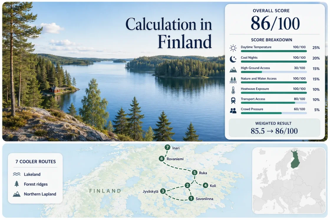
The same seven lake, forest and northern routes appear in the map, score, route cards and comparison matrix.
Three large water systems combine wooded shorelines, cabin inventory and practical town services.
Northern latitude produces the lowest July–August daytime normals in the selected route set.
Direct rail or bus access makes these bases easier to use without a full road-trip itinerary.
Rovaniemi receives midnight sun in early summer, while Inari’s continuous daylight period extends for almost two months.
Finland offers strong water-and-forest cooling but limited mountain altitude; wet spells and mosquitoes can affect northern stays.
From Saimaa Waterways to the Nightless North
The markers connect three Lakeland city-and-cabin bases with Koli’s forest ridge, Ruka’s higher terrain and two Lapland settlements. Marker positions are planning centers rather than guaranteed trailheads, legal parking places or exact cabin locations.
Markers show selected cooler-route regions and public location centers. Use the access notes and Google Maps links in each route card before choosing roads, ferry points, parking areas or trail entrances.
Finland Lake, Forest and Northern-Light Suitability Score
This transparent editorial suitability index measures the seven selected routes with disclosed climate, landscape, access and pressure factors. It is not an official climate classification or a weather forecast, and route count creates no score bonus.
Method: Map-derived official gridded climate-normal comparison using July–August mean daily maximum temperature at each route center; the route median is normalized with the fixed daytime-temperature scale.
Raw: Route median 20.0°C, producing 100/100 because the median is at or below 21°C.
Route values: Savonlinna 21.2°C; Kuopio 21.0°C; Jyväskylä 20.4°C; Koli 20.0°C; Ruka–Kuusamo 18.4°C; Rovaniemi 18.7°C; Inari 17.5°C.
Source mapping: Finnish Meteorological Institute 10 × 10 km climate-normal maps centered on the seven route bases. Grid identifiers are not published in the cited public interface; the displayed values are rounded map-derived route-center estimates rather than exact station or cabin measurements.
Period: July–August, 1991–2020 climate normal.
Sources: Finnish Meteorological Institute 1991–2020 climate maps and FMI temperature normals.
Method: Map-derived official gridded climate-normal comparison using July–August mean daily minimum temperature at each route center; the route median is normalized with the fixed night-cooling scale.
Raw: Route median 10.4°C, inside the 10–16°C full-score band.
Route values: Savonlinna 11.8°C; Kuopio 11.5°C; Jyväskylä 10.7°C; Koli 10.4°C; Ruka–Kuusamo 8.7°C; Rovaniemi 9.1°C; Inari 8.0°C.
Source mapping: The same FMI 10 × 10 km public climate-normal maps used for daytime temperature. Grid identifiers are not published in the cited interface; the displayed values are rounded map-derived estimates, and local shoreline exposure, cloud and wind can shift individual nights.
Period: July–August, 1991–2020 climate normal.
Sources: FMI climate-normal maps, FMI July statistics and FMI August statistics.
Method: Fixed categorical rubric based on accommodation elevation and regular access to meaningful high ground within 60 minutes.
Raw: Median route score 30/100. Finland’s selected routes gain more from water, forest and latitude than from mountain altitude.
Route scores: Savonlinna 30 — low lake basin; Kuopio 30 — Puijo offers local relief but remains below 300 m; Jyväskylä 30 — Laajavuori provides limited elevation; Koli 60 — ridge routes reach roughly 300–354 m; Ruka 60 — Rukatunturi reaches roughly 492 m; Rovaniemi 30 — Ounasvaara is a modest local fell; Inari 30 — higher fell terrain requires a longer transfer.
Period: Access conditions reviewed July 2026; elevation is stable topographic information.
Sources: Metsähallitus Koli National Park, Metsähallitus Oulanka National Park and Finland’s official national parks service.
Method: Fixed access rubric measuring whether large forest, major lake or river systems are physically reachable within 30 minutes.
Raw: Median route score 100/100.
Route scores: Savonlinna 100 — Lake Saimaa plus broad forest cover; Kuopio 100 — Lake Kallavesi plus Puijo forests; Jyväskylä 100 — Päijänne-region water plus surrounding woodland; Koli 100 — Lake Pielinen plus national-park forest; Ruka 100 — Oulanka-area forests plus lakes and rivers; Rovaniemi 100 — Kemijoki and Ounasjoki plus boreal forest; Inari 100 — Lake Inari plus northern pine forest.
Period: Physical access and public-area status reviewed July 2026.
Sources: Metsähallitus Nationalparks.fi, Koli National Park and Oulanka National Park.
Method: Official threshold-frequency fallback. FMI 1991–2020 hot-day frequencies are converted to the share of July–August calendar days because a single common 2016–2025 daily extraction was not applied across all seven route centers.
Raw: Median 30°C+ frequency 0.6%, producing 100/100 under the fixed 0–1% band.
Route values: Savonlinna 1.1%; Kuopio 1.0%; Jyväskylä 0.8%; Koli 0.6%; Ruka–Kuusamo 0.3%; Rovaniemi 0.4%; Inari 0.2%.
Source mapping: Route-center or nearest representative FMI threshold-frequency values, rounded to 0.1 percentage point. Station codes are not published in the cited public tables. These values are climatological fallback frequencies, not claims about a specific future summer.
Period: July–August threshold-frequency normal, 1991–2020.
Sources: FMI hot-weather statistics, FMI long-term weather statistics and FMI heat-warning criteria.
Method: Fixed transport rubric based on regular rail, coach, airport-transfer and local-access patterns.
Raw: Median route score 80/100.
Route scores: Savonlinna 80 — rail connection and usable town base; Kuopio 100 — direct rail and bus access; Jyväskylä 100 — direct rail and bus access; Koli 40 — Joensuu connection plus infrequent or seasonal onward transport; Ruka 80 — Kuusamo Airport and scheduled transfer; Rovaniemi 100 — direct trains, coaches and flights; Inari 80 — Ivalo Airport plus coach connection.
Period: Public transport and airport access reviewed July 2026; timetables remain date-sensitive.
Sources: VR Finnish Railways, Finavia Kuusamo Airport, Finavia Rovaniemi Airport, Finavia Ivalo Airport and official Koli directions.
Method: Fixed categorical pressure rubric using official event calendars, park access guidance, transport capacity and published reservation signals where comparable route-level occupancy data were unavailable.
Raw: Median route score 60/100.
Route scores: Savonlinna 40 — opera-festival dates and lake-cabin demand create strong booking pressure; Kuopio 80 — weekend peaks without widespread capacity controls; Jyväskylä 80 — event pressure is concentrated rather than constant; Koli 40 — trailhead and parking pressure occurs in peak periods; Ruka 60 — popular trailheads and cabins reward early booking; Rovaniemi 60 — summer attractions and limited premium inventory create regular pressure; Inari 80 — lower visitor volume but a relatively small accommodation base.
Period: Current access and event information reviewed July 2026.
Sources: Savonlinna Opera Festival, official Koli access guidance, official Oulanka access guidance, Visit Rovaniemi and Municipality of Inari.
Lake Towns, Forest Ridges and Arctic Bases
The routes separate cabin-oriented lake stays from car-light regional cities, modest high ground and far-northern daylight. Temperature figures are rounded July–August 1991–2020 route-center normals used consistently in the score.
Savonlinna and Lake Saimaa
Savonlinna sits among narrow channels and islands in the Saimaa system, giving cabin stays direct access to water without abandoning town services. The July–August route-center normal is about 21.2°C by day and 11.8°C at night.
Rail access supports a car-light town stay, but shoreline cabins and small islands are often easier with a vehicle, boat transfer or host-arranged pickup. July opera dates tighten accommodation supply.
Kuopio and Lake Kallavesi
Kuopio places a full regional city beside Lake Kallavesi, with passenger-harbor activity, island views and the wooded Puijo ridge close to the center. Rounded July–August normals are 21.0°C by day and 11.5°C at night.
Direct train and coach arrivals make Kuopio one of the easiest bases in the set without a car. Puijo adds shade and local relief, although its elevation is not enough to create a true mountain climate.
Jyväskylä and Lake Päijänne
Jyväskylä works as a transport-efficient entry to Central Finland’s lake network. The city itself lies among Jyväsjärvi and nearby waterways, while the wider Päijänne corridor supports cabin, harbor and island itineraries. The rounded route normal is 20.4°C by day and 10.7°C at night.
Its strongest advantage is logistical: direct rail and coach links reduce arrival friction, then local buses, rental cars or boat services determine how deeply the stay reaches into the cabin landscape.
Koli and Lake Pielinen
Koli adds the clearest ridge-and-lake contrast in the route set. Ukko-Koli rises to roughly 354 m above sea level, enough to create exposure and views over Pielinen but not an alpine temperature regime. The route-center normal is about 20.0°C by day and 10.4°C at night.
Joensuu provides the main rail gateway, while the final connection is less frequent and a car remains useful for dispersed accommodation. Trailhead and parking pressure can be noticeable during fine-weather weekends.
Ruka and Kuusamo
Ruka’s roughly 492 m summit and Kuusamo’s northern inland position produce one of the coolest daytime profiles in the selection: approximately 18.4°C by day and 8.7°C at night across July and August.
Kuusamo Airport and scheduled transfers make the resort base easier to reach than many remote northern trail areas. Oulanka, Karhunkierros access points and lakes extend the route beyond the ski village, but trailhead transport and car use require advance planning.
Rovaniemi and Kemijoki Forests
Rovaniemi is the strongest car-light northern base: overnight trains, daytime rail, coaches and flights all converge near the Kemijoki and Ounasjoki. Rounded July–August normals are 18.7°C by day and 9.1°C at night.
The sun remains above the horizon around June 6–July 7, while usable twilight persists much longer. Bright nights extend walking and riverfront time but can interrupt sleep in rooms without effective blackout curtains.
Inari and Lake Inari
Inari has the lowest rounded daytime normal in the route set at about 17.5°C by day and 8.0°C at night. Lake Inari and surrounding pine forest keep water and shade central to the stay, while the settlement remains small enough for accommodation choice to be limited.
Ivalo Airport and coach connections support a car-light arrival, but trailheads, remote shores and wider Sámi homeland itineraries may still require a vehicle or organized transfer. Continuous daylight lasts for almost two months around the summer solstice.
Which Finnish Base Matches the Cooling Mechanism?
The decision window separates lowest-heat timing, swimming-and-cabin timing, transport convenience and the main route limitation. Every row uses the same seven routes assessed in the score.
| Route | July–August day / night | Car-light access | Cooling mechanism | Decision window | Main trade-off |
|---|---|---|---|---|---|
| Savonlinna and Lake Saimaa | 21.2°C / 11.8°C | Good in town; cabins vary | Large-lake exposure and forest shade | Late June–August for swimming and cabin use | Festival-period booking pressure |
| Kuopio and Lake Kallavesi | 21.0°C / 11.5°C | Strong | Urban lakefront plus Puijo forest | June–August for rail-based lake access | Limited elevation gain |
| Jyväskylä and Lake Päijänne | 20.4°C / 10.7°C | Strong in the city | Lake corridor and woodland | June–August for a city-and-cabin split | Outer cabins often need a car |
| Koli and Lake Pielinen | 20.0°C / 10.4°C | Limited | Forest ridge, exposure and major lake | Late June–early September for ridge walking | Parking and onward transport |
| Ruka and Kuusamo | 18.4°C / 8.7°C | Good to the resort | Northern latitude and higher terrain | July–August for lowest heat with open trails | Rain, insects and trailhead transfers |
| Rovaniemi and Kemijoki Forests | 18.7°C / 9.1°C | Very strong | Northern latitude, rivers and boreal forest | June–early July for midnight sun; August for darker nights | Bright-night sleep disruption |
| Inari and Lake Inari | 17.5°C / 8.0°C | Good to the village | Far-northern latitude, lake and pine forest | Late June–July for continuous daylight; August for twilight | Small accommodation base and remote access |
Saimaa, Kallavesi and Päijänne Do Not Behave Like One Lake District
Saimaa Favors Island Edges and Cabin Transfers
Savonlinna’s waterways fragment the landscape into islands, channels and long shorelines. That structure improves immediate water contact but complicates public transport beyond the town. A rail-based stay works around the center; isolated cabins often require a car, boat or arranged pickup.
Kallavesi Keeps City Services Beside the Water
Kuopio offers the cleanest urban-lake balance in the set. The harbor, islands and Puijo forests sit close to rail-connected services, making it easier to respond to a wet day without abandoning the lake-and-forest character.
Päijänne Requires a City-or-Cabin Decision
Jyväskylä is efficient for arrival and regional services, while the strongest Päijänne cabin experience lies farther south and outside the urban core. The cooling mechanism remains similar, but transport needs change sharply once the itinerary moves from city shoreline to dispersed cottage roads.
Koli and Ruka Trade Alpine Altitude for Accessible Forest Relief
Koli’s roughly 354 m summit and Ruka’s roughly 492 m summit are modest by European mountain standards. Their value comes from exposure, forest cover, lake or river proximity and northern latitude, not a deep alpine temperature gradient.
Koli: Ridge Exposure Above Pielinen
Koli concentrates a large lake, old-growth-influenced forest and open ridge viewpoints in a short walking radius. Fine-weather weekends can create parking pressure, while rain and low cloud may remove the wide views without removing the forest-walking value.
Ruka: Cooler Latitude With a Higher Base
Ruka gains more from its northern position than from summit height alone. The resort base simplifies accommodation and airport transfer, while Oulanka-area routes add rivers, ravines and forest. Trailhead transport should be treated as a separate planning problem from arrival at Ruka village.
Rovaniemi to Inari: Bright Nights Change Sleep More Than Temperature
Rovaniemi’s midnight-sun period runs approximately from June 6 to July 7, while Inari experiences continuous daylight for almost two months around the solstice. The main practical effect is not extra daytime heat; it is the absence of a normal darkness cue for sleep and the ability to move walks, lake trips and road travel into late evening.
Check Blackout Conditions Before Booking
“Darkening curtains” and true blackout curtains are not equivalent. Northern accommodation should be checked for curtain overlap, skylights and glass doors, especially for children or light-sensitive sleepers.
Midsummer Light Is Not Aurora Season
Auroras can occur above Finland in summer, but the sky in Lapland is too bright to see them around midsummer. August restores darker twilight, while the strongest continuous-daylight experience belongs to June and early July.
Insects and Fire Warnings Need Separate Checks
Mosquito pressure often rises near wetlands and sheltered forest after warm, wet periods. During dry spells, Finnish wildfire warnings can restrict open fire even when daytime temperatures remain mild; cabin fireplaces, grills and campfires should follow the current local rule.
When Rain or a Warm Spell Changes the Route
Move Toward Water Exposure on Warm Lakeland Days
In Savonlinna, Kuopio and Jyväskylä, the useful adjustment is usually local rather than cross-country: choose exposed shoreline, an island cruise, a harbor walk or shaded forest instead of a sheltered inland street or south-facing cabin terrace.
Use Rovaniemi or Resort Services During Persistent Rain
Rovaniemi and Ruka provide the strongest indoor-service fallback among the northern routes. Inari is quieter and cooler but has fewer alternatives when wind or prolonged rain limits lake activity, so flexible booking terms carry more value there.