Estonia in Summer: Baltic Islands, Forest Trails and Calm Cooler Towns
Estonia’s cooler summer routes rely on Baltic maritime air, pine-covered islands, shaded bog trails and lake-edge towns rather than high elevation. Hiiumaa and Saaremaa moderate daytime heat most clearly, while Lahemaa and Soomaa add forest cover, wetlands and boardwalk access. Viljandi, Haapsalu, Otepää and the Lake Peipsi shore provide quieter town bases with reliable night-time cooling, although brief inland heatwaves remain possible in July and August.
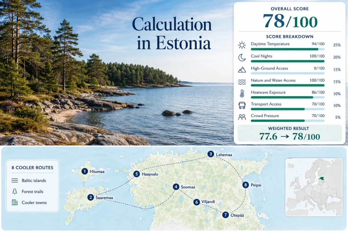
Two Baltic islands, two national parks and four lake or coastal town bases form the shared map, score and comparison set.
The Sõrve station proxy gives Saaremaa the lowest July–August average maximum in the selected route set.
Ristna’s maritime climate, western exposure and extensive coastal forest create the clearest island-based cooling pattern.
Lahemaa combines coast and pine forest; Soomaa adds river wetlands, raised bogs and slower boardwalk routes.
Direct rail and bus connections support a lake-town stay without depending on a ferry or private vehicle.
Estonia’s relief is gentle, so cooler conditions come from latitude, water, forest shade and night-time recovery rather than mountain height.
Vehicle spaces, island accommodation and limited trailhead parking can tighten during peak summer periods.
Baltic Islands, Bog Trails and Lake-Town Bases Across Estonia
The markers connect Estonia’s western islands with northern coastal forest, southwestern wetlands and inland lake towns. Positions represent practical planning centers rather than exact viewpoints, trailheads or legal parking areas.
Markers show selected cooler-route regions and approximate public location centers, not guaranteed trail access, legal parking or precise navigation points. Use the Google Maps link and access notes in each route card before travel.
Estonia Baltic-Island and Forest-Route Suitability Score
This transparent editorial suitability index uses disclosed climate, landscape, transport and peak-pressure factors for the eight routes shown on the map. It is not an official climate classification or a weather forecast. Route count does not create a score bonus; each factor uses the median route value.
Weighted total: 94×0.25 + 100×0.20 + 0×0.15 + 100×0.15 + 86×0.10 + 70×0.10 + 70×0.05 = 77.6 → 78/100
Western Islands, National Parks and Calm Water-Edge Towns
Each route has a different trade-off. The western islands provide stronger maritime moderation, the national parks provide deeper forest and wetland access, and the town bases make public transport and indoor fallback plans easier.
Hiiumaa: Ristna, Tahkuna and Kärdla
Hiiumaa has the strongest combined island-air and forest-road character in the set. The western Ristna coast is more exposed than Kärdla, while Tahkuna adds long pine corridors, beaches and lighthouse country. A bicycle can work for a focused stay, but a car makes the dispersed western and northern sites substantially easier.
Main trade-off: The island feels spacious after arrival, but ferry timing and limited accommodation can shape the entire itinerary.
Open Hiiumaa in Google MapsSaaremaa: Kuressaare, Sõrve and the Western Coast
Sõrve gives Saaremaa the lowest July–August daytime proxy among the eight routes. Kuressaare provides the practical accommodation and bus base, while the Sõrve Peninsula, western coast and forested interior require longer local transfers. The island is easier without a car than Hiiumaa if the stay remains centered on Kuressaare.
Watch for: The southern peninsula is exposed to wind, and a cool coastal morning does not guarantee equally mild conditions in the island interior.
Open Saaremaa in Google MapsLahemaa: Võsu, Käsmu, Oandu and Viru Bog
Lahemaa combines Baltic bays, old-growth forest, former fishing villages and raised-bog terrain within reach of Tallinn. Käsmu’s trail network and the Oandu forest area suit longer walking days, while the Viru bog boardwalk works as a shorter wetland route. Public buses reach selected settlements, but linking several trailheads in one day is far easier by car.
Route scale: The Viru bog route is approximately 3.5 km one way or about 5.5 km as a longer circuit; the Käsmu hiking trail is approximately 15 km.
Open Lahemaa in Google MapsSoomaa: Riisa, Tõramaa and the Bog-River Landscape
Soomaa’s cooling value comes from shade, wetland air and a slow walking pace rather than low measured daytime temperature. Riisa provides a 4.8 km study trail through forest and raised bog, while the visitor-center area supports shorter nature stops. Road distances between trailheads are significant enough that a private vehicle materially improves flexibility.
Capacity note: Riisa’s official parking information lists space for about 10 cars, so an early start matters on clear summer weekends.
Open Soomaa in Google MapsHaapsalu and Matsalu Bay
Haapsalu offers the easiest low-stress western-coast town stay in the set. The compact center, bayfront paths and direct bus connections reduce daily transport effort. Matsalu National Park broadens the landscape toward reed beds, coastal meadows and bird habitats, although reaching dispersed observation points generally requires a car.
Good for: Travelers who want sea air and evening walks without committing to an island ferry.
Open Haapsalu in Google MapsViljandi: Lake Shore, Castle Hills and Rail Access
Viljandi combines a direct rail connection with lake access, steep local paths and a compact historic center. It does not have the maritime moderation of the islands, but its night-time normal remains favorable and a car is unnecessary for the core town-and-lake experience.
Main caution: Late-July festival demand can transform a normally calm base into one of Estonia’s most capacity-constrained small towns.
Open Viljandi in Google MapsOtepää: Pühajärv and South Estonia’s Rolling Uplands
Otepää has the strongest local relief in the route set, but it remains far below true mountain elevations. Pühajärv and the surrounding forest provide swimming, cycling and shaded walking options, while cool nights create stronger recovery than the daytime figure suggests.
Why it stands out: Otepää works as an activity base with water and woodland close together, not as a high-altitude refuge.
Open Otepää in Google MapsAlatskivi, Kallaste and the Lake Peipsi Shore
Lake Peipsi creates a broad waterside route with stronger night cooling than Estonia’s island stations. Alatskivi provides the most practical cultural base, while Kallaste and the lakeshore villages add beaches, sandstone exposures and long views across the water. Bus access exists, but a car simplifies movement between scattered settlements.
Watch for: Easterly airflow can allow the lakeshore to warm sharply despite its water exposure, so the route is not automatically cooler every afternoon.
Open Lake Peipsi in Google MapsTwo Ferry Systems Shape the Western-Island Loop
Mainland to Saaremaa
The Virtsu–Kuivastu crossing reaches Muhu before the road continues to Saaremaa. Through-bus connections make Kuressaare possible without a car, but the Sõrve Peninsula and western coastal stops become considerably harder to combine.
Mainland to Hiiumaa
The Rohuküla–Heltermaa route is the primary year-round sea connection. Kärdla can function as a base, although Ristna, Kõpu and Tahkuna are dispersed enough that bicycle range, bus timing or vehicle access must be decided before arrival.
Sõru–Triigi Between the Islands
The direct Hiiumaa–Saaremaa crossing can turn two separate island stays into a continuous loop. It has fewer departures than the main mainland links, so the sailing should be fixed before accommodation and driving stages are arranged around it.
Practical sequence: Secure the limited inter-island or vehicle-ferry segment first. A missed connection can create a long return through the mainland rather than a short timetable adjustment.
Viru and Riisa Can Feel Different From Their Nearest Town Forecast
Viru Bog: Shade First, Open Exposure Later
The approach begins in forest, but the raised-bog boardwalk becomes open to sun and wind. A mild forecast at the coast can still produce a warm exposed crossing around midday, especially when cloud breaks follow a cool morning.
Riisa: Wetland Air and Limited Parking
Riisa’s wetland setting can feel cooler in shade yet more humid after rain. The small parking area creates a separate capacity issue, so early or later-day arrivals can improve both thermal comfort and trail access.
Hüpassaare Reconstruction in 2026
RMK lists the Hüpassaare study trail as closed for reconstruction until August 1, 2026. Access status should be checked again before using it as a Soomaa alternative.
Bog routes need sun protection, drinking water and insect protection even when the regional temperature appears mild. Wet timber, thunderstorms and temporary reconstruction can matter more than a one- or two-degree temperature difference.
Viljandi by Rail, Haapsalu by Bus and National Parks by Car
A Rail-Based Viljandi Stay
Viljandi station, the historic center and the lake can form a complete two- or three-night stay without a vehicle. Rail engineering notices should still be checked because summer work can alter departure times or replacement-bus arrangements.
A Bus-Based Haapsalu Stay
Regular coach access and a compact center make Haapsalu the simpler coastal choice without a car. Matsalu observation points and more remote beaches should be treated as separate excursions rather than assumed walkable extensions.
Driving Between Park Trailheads
Lahemaa and Soomaa contain individually accessible stops but weak point-to-point public transport. A car changes the route from one settlement or trail into a broader national-park circuit, especially when rain requires a rapid change of plan.
Eight Routes by Cooling Mechanism, Access and Peak Pressure
The temperature columns use the same July–August station mappings as the score. Access and pressure describe the practical route rather than the nearest weather station.
| Route | Day / Night Proxy | Main Cooling Mechanism | Car Need | Peak Pressure | Rainy-Day Fallback |
|---|---|---|---|---|---|
| Hiiumaa | 20.6°C / 14.3°C | Western Baltic exposure and pine forest | Useful for full-island coverage | Ferry vehicles and limited rooms | Kärdla museums, cafés and shorter forest stops |
| Saaremaa | 20.3°C / 14.9°C | Sõrve maritime air and open coastline | Optional in Kuressaare; useful beyond it | Ferry and Kuressaare accommodation demand | Kuressaare indoor sites and town walks |
| Lahemaa | 21.4°C / 12.8°C | Coastal forest, bays and bog terrain | Strongly useful for multiple trailheads | Viru bog and coastal parking | Manor sites and shorter forest routes |
| Soomaa | 22.4°C / 13.2°C | Wetland air, rivers and deep forest | Strongly useful | Small trailhead parking areas | Visitor-center stops and shorter study trails |
| Haapsalu | 22.4°C / 11.8°C | Bay exposure and strong night recovery | Not needed for the town core | Event-weekend rooms | Compact historic center and indoor attractions |
| Viljandi | 22.6°C / 12.4°C | Lake access and cool nights | Not needed for the central route | Late-July festival capacity | Museums, cafés and short castle-hill walks |
| Otepää | 22.9°C / 12.1°C | Forest, lakes and rolling uplands | Helpful but not essential for Pühajärv | Localized activity weekends | Short forest loops and town facilities |
| Lake Peipsi | 22.1°C / 11.8°C | Large-lake air and night cooling | Helpful for scattered shore villages | Localized beach and village demand | Alatskivi indoor sites and food stops |
Before departure: Check the Estonian Environment Agency forecast, island ferry capacity, Elron engineering notices, RMK trail alerts and local event calendars. Estonia can produce short inland hot spells even when the broader Baltic pattern remains mild.