Poland in Cooler Summer Mode: Tatra Towns, Lake Districts and Baltic Air
Poland’s less-hot summer routes divide into three distinct systems: high bases and rapid altitude gain around the Tatras and Karkonosze, water-and-forest exposure across the Great Masurian Lakes, and maritime moderation on the Hel Peninsula and the Słowiński coast. The useful choice is not simply north versus south; it is whether daytime relief, cool nights, car-light access or water-based travel matters most.
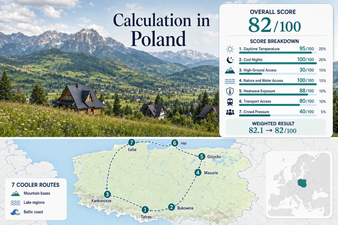
Three mountain bases, two Masurian lake hubs and two Baltic gateways form the common route set used in the map, score and comparison.
A roughly 800–950 m lodging band, cool normal nights and quick access toward the high Tatras create the clearest heat-wave fallback.
The value is the July–August mean of IMGW 1991–2020 average daily maxima at Łeba station, not a forecast.
All seven representative stations sit inside the scoring system’s favorable overnight band for the July–August target window.
POLREGIO announced up to 42 daily Gdynia–Hel connections from 27 June 2026, reducing the need to drive the narrow peninsula.
Morskie Oko parking, Hel trains and Łeba park gateways need earlier decisions during Polish school-holiday weeks.
Tatras, Masuria and Baltic Route Geography
The markers separate Poland’s mountain, lake and coast systems rather than suggesting one continuous loop. Positions use public settlement or planning centers; they are not guaranteed legal parking points, trailheads or exact viewpoints.
This marker map is for planning orientation. Use each route card for a place-specific Google Maps search and verify current park, rail and parking information before departure.
Poland Cooler Escape Suitability Score
This transparent editorial suitability index uses disclosed climate, landscape, access and pressure factors for the seven featured routes. It is not an official climate classification, a safety rating or a weather forecast.
Method: The July–August average daily maximum was calculated for each assigned IMGW station, then the seven route values were combined by median.
Raw: Median 22.1°C; linear interpolation between 21°C = 100 and 23°C = 90 gives 94.5, rounded to 95.
Route values: Zakopane and Kościelisko 21.3°C; Bukowina Tatrzańska and Białka Tatrzańska 21.3°C; Karpacz and Szklarska Poręba 23.8°C; Mikołajki and Lake Śniardwy 23.6°C; Giżycko and the Niegocin–Mamry Lakes 23.8°C; Hel Peninsula 22.1°C; Łeba and Słowiński National Park 21.6°C.
Station mapping: Zakopane 12625 is direct for the Zakopane base and a conservative representative for eastern Podhale; Jelenia Góra 12500 is a lower, warmer representative for the Karkonosze towns; Mikołajki 12280, Hel 12135 and Łeba 12120 are direct; Kętrzyn 12185 represents Giżycko at similar lowland elevation.
Period and source: 1991–2020. IMGW average maximum temperature normals.
Method: July–August average daily minima were assigned with the same station mapping and combined by route median.
Raw: Median 13.2°C, inside the fixed 10–16°C band that scores 100.
Route values: Zakopane and Kościelisko 10.7°C; Bukowina Tatrzańska and Białka Tatrzańska 10.7°C; Karpacz and Szklarska Poręba 11.1°C; Mikołajki and Lake Śniardwy 14.2°C; Giżycko and the Niegocin–Mamry Lakes 13.2°C; Hel Peninsula 15.0°C; Łeba and Słowiński National Park 13.4°C.
Period and source: 1991–2020. IMGW average minimum temperature normals.
Method: Fixed altitude-and-access rubric, scored route by route and combined by median.
Route scores: Zakopane and Kościelisko 100 — high lodging bases and regular access toward terrain above 1,500 m; Bukowina Tatrzańska and Białka Tatrzańska 100 — elevated bases near Tatra approaches; Karpacz and Szklarska Poręba 100 — bases and trails rise rapidly toward 1,362–1,602 m; Mikołajki 30 and Giżycko 30 — low relief; Hel 0 and Łeba 0 — no meaningful high-ground access.
Raw: Median route score 30.
Current-status sources: Tatra National Park access information and Karkonosze National Park trail elevations and seasonal windows. Reviewed July 15, 2026.
Method: Fixed 30-minute physical-access rubric; scenery quality is not scored.
Route scores: Zakopane and Kościelisko 75, Bukowina Tatrzańska and Białka Tatrzańska 75, and Karpacz and Szklarska Poręba 75 for immediate extensive forest access; Mikołajki 100 and Giżycko 100 for large lakes plus forest; Hel 100 for sea plus coastal woodland; Łeba 100 for Baltic coast, forest and the Łebsko lake system.
Raw: Median route score 100.
Current-status sources: Warmia–Masuria official tourism map, Słowiński National Park visitor information, and the two mountain park sources cited above.
Method: Official threshold-frequency fallback. IMGW 1991–2020 monthly normal counts of days at or above 30°C were summed for July and August, divided by 62 calendar days and assigned through the same direct or representative stations.
Route values: Zakopane and Kościelisko 2.4%; Bukowina Tatrzańska and Białka Tatrzańska 2.4%; Karpacz and Szklarska Poręba 7.9%; Mikołajki and Lake Śniardwy 4.8%; Giżycko and the Niegocin–Mamry Lakes 4.0%; Hel Peninsula 0.6%; Łeba and Słowiński National Park 0.8%.
Raw: Median 2.4%; interpolation between 2% = 90 and 5% = 75 gives 88.
Period and source: 1991–2020 climatological frequency fallback, not a ten-summer daily extraction. IMGW days with maximum temperature at or above 30°C.
Method: Fixed public-transport rubric based on the route base, not every trailhead or shoreline.
Route scores: Zakopane and Kościelisko 100 — rail to Zakopane plus local buses; Bukowina Tatrzańska and Białka Tatrzańska 80 — regular bus access from a main hub; Karpacz and Szklarska Poręba 80 — rail and bus combination; Mikołajki 80; Giżycko 100 — direct rail base; Hel 100 — frequent summer peninsula rail; Łeba 80 — seasonal rail and local park transfers.
Raw: Median route score 80.
Current-status sources: PKP national journey planner, POLREGIO 2026 summer Hel service notice, and TPN regular Zakopane–Palenica transport information. Reviewed July 15, 2026.
Method: Categorical fallback because comparable route-level occupancy was unavailable. Scores follow documented parking, transport, park-entry and coastal accommodation pressure in the same direction as the fixed occupancy rubric.
Route scores: Zakopane and Kościelisko 20 — Morskie Oko parking and major trailhead pressure; Bukowina Tatrzańska and Białka Tatrzańska 40; Karpacz and Szklarska Poręba 40; Mikołajki 40; Giżycko 40; Hel 20 — narrow-corridor summer demand; Łeba 20 — coastal lodging and park-gateway pressure.
Raw: Median route score 40.
Period and sources: Latest completed tourism year and current access rules. Statistics Poland coastal tourism, July–August 2024, TPN Morskie Oko parking rules, and Statistics Poland tourism in 2024.
Weighted total: 95×0.25 + 100×0.20 + 30×0.15 + 100×0.15 + 88×0.10 + 80×0.10 + 40×0.05 = 82.1 → 82/100
Method: Every route carries equal weight. Route values are reduced to a factor median before the fixed factor weights are applied.
Tatra Bases, Masurian Water Towns and Baltic Gateways
The seven routes are separate trip models. Combining all three regions in one short stay adds long transfers and weakens the main advantage of choosing a cooler base.
Zakopane and Kościelisko
July–August normals: about 21.3°C average maximum and 10.7°C average minimum at Zakopane station 12625. Lodging commonly sits around 800–950 m, while Kuźnice and valley buses provide access toward much higher terrain.
Bukowina Tatrzańska and Białka Tatrzańska
The two eastern Podhale bases trade Zakopane’s rail convenience for higher village positions and faster road access toward Łysa Polana. The Zakopane station proxy gives 21.3°C/10.7°C July–August max/min normals; actual village conditions vary with slope and elevation.
Access profile: Bus-friendly from Kraków or Zakopane, but a car improves flexibility between villages and trail approaches. The route works for travelers who want a quieter lodging base without giving up Tatra day trips.
Karpacz and Szklarska Poręba
Karkonosze elevation changes quickly: an official Szrenica educational route rises from 718 m to 1,362 m over 12 km, while the Biały Jar–Śnieżka route climbs from 760 m to 1,602 m. Jelenia Góra’s warmer low-base proxy is 23.8°C/11.1°C for July–August.
Mikołajki and Lake Śniardwy
Mikołajki station 12280 records a 23.6°C average July–August maximum and 14.2°C minimum. The cooling value comes from immediate water access rather than altitude: Lake Mikołajskie, Tałty and the route toward Śniardwy connect sailing, cycling and shaded shoreline time.
Car-free stays are possible in town, though a car or boat expands access to forest edges and less concentrated shores.
Giżycko and the Niegocin–Mamry Lakes
Giżycko is the stronger rail-based Masurian hub. Kętrzyn station 12185, used as a similar-elevation representative, gives 23.8°C average maxima and 13.2°C minima in July–August. Niegocin, Kisajno and the canal network place open water within minutes of the center.
The route feels most useful when water transport is part of the day. Staying only on paved urban streets removes much of the lake district’s cooling logic.
Hel Peninsula
Hel station 12135 has a 22.1°C July–August average maximum and 15.0°C minimum. The peninsula adds exposure to both Puck Bay and the open Baltic, but wind direction can turn the same day from calm and warm to sharply cooler.
Łeba and Słowiński National Park
Łeba station 12120 is the coolest daytime station in this set at 21.6°C for the July–August average maximum, with a 13.4°C average minimum. The route combines Baltic exposure, coastal forest, Lake Łebsko and the moving-dune corridor.
Measured route detail: The park’s Stara Łeba–coast–Łącka Dune loop is 15.1 km. Entry fees apply on selected trails from 1 May to 30 September, and the Rąbka gateway concentrates peak-season arrivals.
Podhale Altitude, Masurian Water and Baltic Exposure
Podhale Changes the Night First
Zakopane’s daytime normal is already low for Poland, but the larger comfort advantage arrives after sunset. A 10.7°C normal minimum gives buildings and streets more time to release heat, while the option to climb toward Kasprowy Wierch provides a second temperature band during hot spells.
Masuria Depends on Daily Water Use
Mikołajki and Giżycko are not mountain-cool. Their value comes from lake crossings, shoreline cycling, forest margins and evening air movement. Marina-centered July stays can still feel busy and humid, so water proximity matters more than the regional label alone.
Baltic Wind Can Reverse the Day
Hel and Łeba have the lowest daytime heat exposure in the set, yet beach comfort is less stable. Offshore flow can warm the coast; onshore flow can add cloud, spray and a much cooler feel. A light wind layer belongs in the day bag even when inland Poland is hot.
Morskie Oko Buses, Peninsula Rail and Masurian Transfers
Use the Bus for the Busiest Tatra Trailhead
TPN sells dated Morskie Oko parking and also lists regular Zakopane–Palenica transport. A bus-based day removes the risk of being assigned a more distant parking segment and suits a Zakopane or Kościelisko base.
Treat Hel as a Rail Corridor
The peninsula’s settlement chain aligns with the railway. Jastarnia, Jurata and Hel can be combined without repeatedly moving a car, while summer frequency absorbs day-trip demand that would otherwise sit on one narrow road.
Masuria Keeps a Last-Mile Problem
Giżycko works well as a train base and Mikołajki can be reached by public transport, but remote beaches, forest roads and dispersed accommodation remain easier by bicycle, boat or car. Choose the town before choosing the transport mode.
Seven Routes by Heat, Night Relief and Mobility
The climate values are July–August 1991–2020 station normals used in the score. Access descriptions refer to the route base, not every beach, trail or viewpoint.
| Route | Max / Min Normal | Main Cooling System | Car-Light Strength | Peak Constraint | Map |
|---|---|---|---|---|---|
| Zakopane and Kościelisko | 21.3°C / 10.7°C | Altitude and night cooling | Strong from Zakopane | Trailhead and parking demand | Zakopane map |
| Bukowina Tatrzańska and Białka Tatrzańska | 21.3°C / 10.7°C proxy | High village bases | Moderate | Road dependence between sites | Bukowina map |
| Karpacz and Szklarska Poręba | 23.8°C / 11.1°C warm proxy | Rapid vertical gain | Moderate | Rain and ridge weather | Karkonosze map |
| Mikołajki and Lake Śniardwy | 23.6°C / 14.2°C | Large-lake exposure | Moderate in town | Marina and lodging pressure | Mikołajki map |
| Giżycko and the Niegocin–Mamry Lakes | 23.8°C / 13.2°C proxy | Lake network and evening breeze | Strong base access | Dispersed shoreline last mile | Giżycko map |
| Hel Peninsula | 22.1°C / 15.0°C | Baltic and bay exposure | Very strong in summer | Wind shifts and corridor demand | Hel map |
| Łeba and Słowiński National Park | 21.6°C / 13.4°C | Coast, forest and coastal lakes | Moderate, partly seasonal | Rąbka gateway concentration | Łeba map |
Late June, Holiday Peak and Early September
Late June for Long Days and Lower Pressure
Mountain routes usually have broad hiking access, summer rail additions begin, and the main domestic holiday surge is still building. Baltic water remains cool, so this period favors walking and cycling over swimming.
July–August for Full Access with Capacity Costs
All seven routes operate at full summer rhythm. The score targets these months, but Tatra parking, Karkonosze trails, Masurian marinas and Baltic accommodation face their strongest shared pressure.
Early September for Quieter Bases
Night cooling strengthens and domestic demand usually eases. Some seasonal rail, boat and visitor services reduce frequency, so confirm the return connection before choosing Hel, Łeba or a dispersed Masurian base.