Luxembourg Cooler Routes: Forest Gorges, River Valleys and Compact Rail Escapes
Luxembourg compresses several different summer conditions into short public-transport journeys: the shaded rock corridors of the Müllerthal, the incised Alzette and Pétrusse valleys beneath the capital, the wooded Our and Wiltz valleys in the north, and the warmer Moselle corridor in the southeast. The country is not a guaranteed refuge from heat, but its free transport network makes it unusually practical to switch from an exposed town afternoon to forest shade, flowing water or a higher northern plateau without building an entire trip around a car.
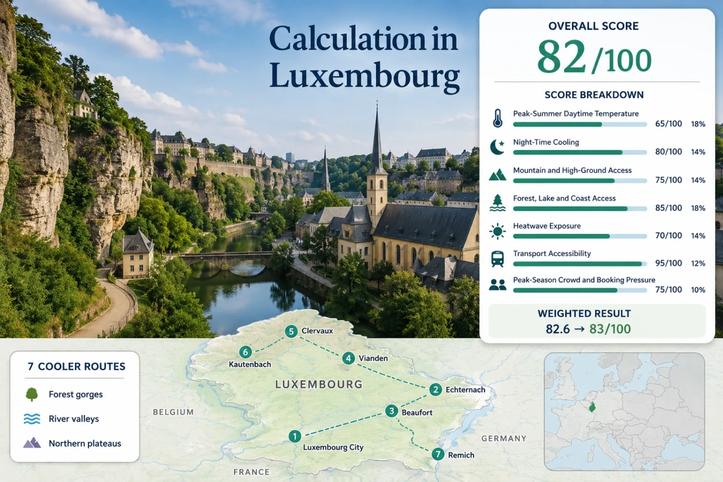
The same seven places appear in the map, score evidence, route portfolio and decision table.
Luxembourg City, Clervaux and Kautenbach allow the clearest station-to-shade transitions.
Narrow sandstone passages, stream valleys and dense woodland reduce direct solar exposure.
Clervaux, Vianden and Kautenbach trade deep gorge shade for wooded slopes and more open high ground.
Remich works through river access and shaded timing rather than a strong altitude advantage.
Domestic trains, trams and buses can be combined without a standard second-class fare.
From Pétrusse Ravines to the Moselle Bend
The markers follow a south-to-north sequence through the capital valleys, Müllerthal gorges, Éislek river towns and the Moselle. They are planning centers rather than exact trailheads, parking areas or viewpoints.
Markers show selected cooler-route regions and approximate public location centers, not guaranteed legal parking, exact viewpoints or trail entrances. Use the route links and current transport information before traveling.
Luxembourg Forest-and-Rail Suitability Score
This transparent editorial suitability index uses disclosed climate, landscape, access and pressure factors. It is not an official climate classification, a personal comfort guarantee or a weather forecast.
The score favors comfortable nights, immediate forest-and-water access and car-light mobility. Luxembourg loses points because meaningful high ground is modest and heat episodes still reach the low valleys.
Method: Representative-station climate normal. The July and August mean daily maxima at Luxembourg/Findel are 23.9°C and 23.5°C; their arithmetic mean is 23.7°C. The fixed scale places 23°C at 90 and 25°C at 75, producing 84.75, displayed as 85.
Raw route values: Luxembourg City Valleys 23.7°C; Echternach–Berdorf Gorges 23.7°C; Beaufort–Larochette Ernz Valleys 23.7°C; Vianden and the Our Valley 23.7°C; Clervaux Rail-and-Forest Loop 23.7°C; Kautenbach and the Wiltz Valley 23.7°C; Remich Moselle Promenade 23.7°C. Median: 23.7°C.
Station relationship: Luxembourg/Findel, WMO 06590, approximately 376 m elevation, is used as a national representative station. Route centers lie roughly 7–50 km away and include lower river valleys as well as northern plateaus, so route-level microclimate differences are not claimed.
Period: 1991–2020 climatological normal. Sources: MeteoLux monthly normal dataset and MeteoLux normal and extreme values.
Method: Representative-station climate normal. The July and August mean daily minima at Luxembourg/Findel are 13.8°C and 13.6°C; their arithmetic mean is 13.7°C. Values from 10°C through 16°C receive 100 under the fixed night-cooling scale.
Raw route values: All seven route centers use the same 13.7°C station proxy. Median: 13.7°C. This measures the normal overnight relief signal, not the coldest possible night in a gorge or northern valley.
Period: 1991–2020 climatological normal. Sources: MeteoLux monthly normal dataset and MeteoLux climate tables.
Method: Fixed categorical high-ground rubric applied route by route. Luxembourg offers meaningful short climbs and plateau access, but none of the assessed bases reaches the 600 m or 900 m bands used for stronger categories.
Route scores: Luxembourg City Valleys 60 — roughly 300 m urban plateau above incised valleys; Echternach–Berdorf Gorges 60 — official route range 162–387 m; Beaufort–Larochette Ernz Valleys 60 — official route range 185–420 m; Vianden and the Our Valley 60 — valley base with chairlift access to about 440 m; Clervaux Rail-and-Forest Loop 60 — Éislek slopes and plateaus; Kautenbach and the Wiltz Valley 60 — steep valley-to-plateau walking; Remich Moselle Promenade 30 — limited elevation advantage. Median: 60.
Current access basis: Reviewed 18 July 2026. Sources: Müllerthal Route 2 data, Müllerthal Route 3 data, Vianden chairlift information and Éislek regional geography.
Method: Fixed physical-access rubric. A route receives 100 when at least two strong elements among extensive forest, a major lake or river system, and a coast are reachable within about 30 minutes.
Route scores: Luxembourg City Valleys 100 — wooded urban slopes plus the Alzette and Pétrusse; Echternach–Berdorf Gorges 100 — dense forest plus stream-cut rock passages and nearby lake access; Beaufort–Larochette Ernz Valleys 100 — forest plus Black and White Ernz systems; Vianden and the Our Valley 100 — Our River plus forested slopes; Clervaux Rail-and-Forest Loop 100 — wooded Éislek valleys plus local waterways; Kautenbach and the Wiltz Valley 100 — river valley plus continuous forest; Remich Moselle Promenade 100 — Moselle frontage plus wooded and vineyard-backed slopes. Median: 100.
Current access basis: Reviewed 18 July 2026. Sources: Capital valley information, Müllerthal gorge route, Vianden and Our Valley, Éislek forests and valleys and Remich riverfront setting.
Method: Official threshold-frequency fallback. MeteoLux publishes a 1991–2020 normal of 7.2 hot days at 30°C or above for the 92-day meteorological summer. That equals 7.8% of summer days. The fixed heat-exposure scale interpolates 7.8% between 5% at 75 and 10% at 55, producing 63.8, displayed as 64.
Route values: The same 7.8% national-station proxy is used for all seven routes; median 7.8%. A route-level July–August split was not published in the cited summary, so no exact target-month event count is claimed. This fallback is the main reason for comparability quality C.
Period: 1991–2020 threshold normal rather than the preferred latest ten completed summers. Sources: MeteoLux climate summary with the 7.2-day normal and MeteoLux daily parameter dataset.
Method: Fixed transport rubric using regular public access and private-car dependence.
Route scores: Luxembourg City Valleys 100 — direct rail, tram and urban bus; Echternach–Berdorf Gorges 100 — regular interurban buses and local connections; Beaufort–Larochette Ernz Valleys 80 — bus access with route coordination; Vianden and the Our Valley 80 — rail gateway plus regular bus; Clervaux Rail-and-Forest Loop 100 — direct train and station-based walking; Kautenbach and the Wiltz Valley 100 — direct train and rail-hike structure; Remich Moselle Promenade 100 — regular direct buses and a bus station at the walking start. Sorted median: 100.
Current network basis: Reviewed 18 July 2026. Domestic second-class public transport has no standard fare. Sources: Mobilitéit fare rules, official bus lines, Clervaux station access, Kautenbach rail access and Remich bus access.
Method: Official-capacity categorical fallback because comparable July–August occupancy is not published for all seven route zones. Scores use concentration points, trail geometry, station dispersal and seasonal attraction capacity rather than invented occupancy percentages.
Route scores: Luxembourg City Valleys 40 — concentrated capital demand; Echternach–Berdorf Gorges 40 — narrow passages and prominent Müllerthal day use; Beaufort–Larochette Ernz Valleys 65 — multiple trailheads and a more dispersed two-day corridor; Vianden and the Our Valley 40 — castle and seasonal chairlift concentration; Clervaux Rail-and-Forest Loop 65 — rail-base demand spread across a loop; Kautenbach and the Wiltz Valley 85 — station-to-station dispersal with fewer single-site bottlenecks; Remich Moselle Promenade 65 — demand spread along a roughly 3 km riverfront. Median: 65.
Evidence window: Latest completed national tourism publication available at review plus current official route and attraction access pages. Sources: STATEC tourism figures, Müllerthal route geometry, Vianden seasonal chairlift and Clervaux rail-hike dispersion.
Seven Routes Across Gorges, Rails and River Bends
Each route uses a distinct cooling mechanism. The Müllerthal relies on shade and stone passages, the Éislek on wooded valley relief and northern plateaus, the capital on deeply cut urban rivers, and Remich on water access paired with careful time-of-day planning.
The Alzette and Pétrusse sit below the upper city rather than beyond it. An official 6.43 km circular walk links the rail-and-tram network with lower paths, stone walls, wooded slopes and repeated exits back to urban services. The route gains comfort from topographic shade and short escape options, not from high elevation.
Müllerthal Trail Route 2 forms the strongest deep-shade corridor in the set. Its official profile covers 39.65 km, ranges from 162 m to 387 m and passes Wollefsschlucht, Kuelscheier and the Schéissendëmpel area. The full circuit is long, so summer use is more practical as selected sections from Echternach, Berdorf or Consdorf rather than a single hot-day push.
Route 3 shifts the Müllerthal experience from tight rock corridors toward the Black Ernz, White Ernz and wooded links between Beaufort and Larochette. The official circuit is 37.69 km with a 185–420 m elevation range. Its cooler logic is distributed: streamside forest, castle-town breaks and repeated shaded sections rather than one concentrated cleft.
Vianden combines a compact river town with steep wooded sides and a seasonal chairlift that reaches roughly 440 m. It does not provide alpine altitude, but the quick vertical change creates a useful choice between the shaded Our promenade, hillside paths and exposed viewpoints. Bus links from northern rail gateways keep the route practical without a car.
Clervaux is one of the cleanest rail-to-trail transitions in northern Luxembourg. The official Éislek Pad loop is 13.68 km, and the station sits close enough to make the town a realistic base rather than only a transfer point. Wooded slopes and plateau edges offer more airflow and elevation variation than the Moselle, while the rail line provides a straightforward retreat if storms or heat build.
Kautenbach is a small rail junction embedded in a narrow wooded valley. The official local loop is 11.13 km, and longer station-to-station options use the same rail corridor. Compared with Vianden, there is less dependence on a single attraction; the experience is shaped by continuous forest, river bends and repeated climbs from the valley floor.
Remich is included as a contrast rather than Luxembourg’s strongest low-heat option. Its roughly 3 km Moselle promenade offers water proximity, tree shade and simple bus access, but the sheltered southeastern valley can feel warmer than the Éislek or Müllerthal. The route works most convincingly in the morning, after a shower, or toward evening.
Where Shade Sits Below Luxembourg’s Plateaus
Luxembourg’s useful summer relief often appears below the surrounding settlement level. The practical question is not simply north versus south; it is whether a route places the traveler inside a shaded incision, beside moving water or on an open slope during the hottest hours.
The upper city can remain bright and paved while lower paths gain wall shade, tree cover and immediate river contact. Multiple lifts, bridges and streets provide short exits.
Rock fissures interrupt direct sun more strongly than open woodland. The trade-off is damp footing and slower movement through narrow sections.
Vianden, Clervaux and Kautenbach mix river shade with climbs to exposed plateaus. Their advantage increases when mornings and late afternoons are used for higher ground.
Rail First, Bus Last Across Seven Compact Travel Chains
The same seven routes can be compared through the transfer that matters most: how quickly public transport reaches shade or water, and whether the last segment remains flexible when the weather changes.
| Route | Public transport chain | Main cooling mechanism | Useful scale | Primary trade-off |
|---|---|---|---|---|
| Luxembourg City Valleys | National rail to the capital, then tram T1 or urban bus | Incised valleys, trees and two waterways | 6.43 km official circuit with many exits | Urban surfaces remain warm above the valleys |
| Echternach–Berdorf Gorges | Interurban bus to Echternach or Berdorf, then local walking sections | Sandstone clefts, forest and stream shade | 39.65 km full Route 2; sectional use is more heat-aware | Narrow wet passages and peak-day concentration |
| Beaufort–Larochette Ernz Valleys | Regional buses linked through Müllerthal towns | Black and White Ernz stream corridors | 37.69 km full Route 3, suited to staged travel | More timetable coordination than a station loop |
| Vianden and the Our Valley | Train to a northern gateway, then bus 181, 182 or 188 | Our River, forested slopes and short vertical gain | River promenade, hillside paths and seasonal chairlift | Castle and chairlift demand concentrates midday |
| Clervaux Rail-and-Forest Loop | Direct northern train to Clervaux | Wooded Éislek slopes and plateau edges | 13.68 km official loop from the rail base | Open ridge portions can be bright in the afternoon |
| Kautenbach and the Wiltz Valley | Direct northern train to Kautenbach | Narrow wooded valley and river bends | 11.13 km local loop plus one-way rail-hike options | Steep climbs demand more effort in humid weather |
| Remich Moselle Promenade | Direct regional bus, including lines serving Remich station | Moselle water access and tree-lined riverfront | Roughly 3 km promenade | Low elevation and warmer southeastern valley air |
Müllerthal Clefts, Éislek Ridges and Moselle Timing
These three landscape systems should not be treated as interchangeable. They solve different summer problems and produce different access decisions.
Berdorf and the Ernz valleys provide the strongest physical shade. Select shorter gorge segments after rain rather than assuming the complete trail is suitable for a hot day.
Clervaux and Kautenbach allow longer forest movement while preserving a direct rail exit. Vianden adds the Our River but requires a bus connection.
Remich offers immediate river contact and a level promenade, but it should be scheduled around morning shade or evening relief because elevation does not offset valley warmth.
A July–August Clock for Rail, Gorges and Riverfronts
The score window covers July and August, yet route comfort changes more by hour, cloud cover and recent rainfall than by the short distance between many towns.
Use morning trains for Clervaux, Kautenbach or Vianden climbs. Higher and open sections are easier before heat accumulates on plateaus and castle slopes.
Shift toward Pétrusse, Berdorf or streamside Müllerthal sections. Shade is most valuable when it interrupts direct sun continuously, not merely at occasional forest edges.
Remich and the capital river paths become more convincing after the strongest solar period. Evening buses and trains preserve flexibility without a parked car.
Rain can improve air feel while making sandstone and roots slippery. Replace a complete Müllerthal stage with a shorter signed segment and retain a bus exit.