Netherlands for Breezy Summer Breaks: Wadden Islands, Dune Coasts and Canal Towns
The Netherlands offers three different forms of summer relief: exposed Wadden islands with ferry-defined travel rhythms, North Sea dune corridors where rail and tram lines reach the beach, and canal or wetland towns where water shapes the day without guaranteeing a sea breeze. The central decision is whether the trip should prioritize the lowest daytime temperatures, the simplest car-free access, or a sheltered waterside base with cooler nights.
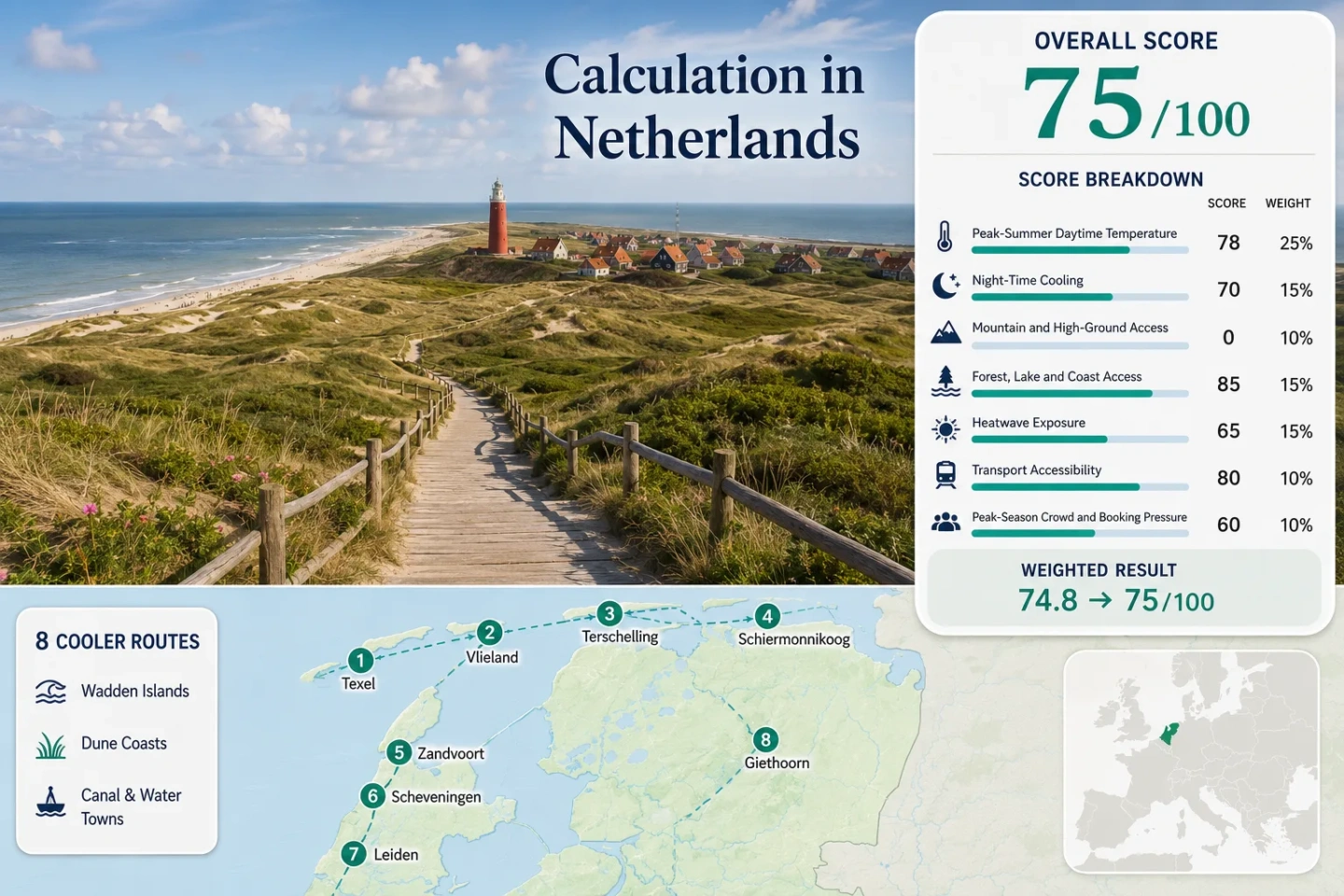
Four Wadden islands, three dune-coast corridors and one inland wetland base are used throughout the map, score and comparison.
Texel, Vlieland, Terschelling and Schiermonnikoog share maritime exposure but use different ferry and vehicle rules.
Vlieland and Terschelling use Hoorn Terschelling’s July–August 1991–2020 mean maximum; it is not a forecast.
Direct trains, trams and short bicycle or bus links make the mainland coast simpler without ferry timing.
Dunes affect wind and shade, but no route reaches the scoring system’s 300 m threshold.
Preferred ferries, sunny-weekend coast transport and Giethoorn boat traffic reward early decisions.
Wadden Ferries, North Sea Dunes and Water-Town Bases
The markers separate island, dune-coast and inland-water trip models rather than forming one efficient loop. They show planning centers, not parking, ferry lanes or trail entrances.
Use the place-specific map searches and current ferry, park or transport information in each route card before travelling.
Netherlands Coastal Cooler Escape Suitability Score
This transparent editorial suitability index uses disclosed climate, landscape, access and pressure factors for the eight featured routes. It is not an official climate classification, a safety rating or a weather forecast.
Method: Representative Station aggregation of July–August KNMI mean daily maxima, reduced to the eight-route median.
Raw: Median 21.675°C; interpolation between 21°C = 100 and 23°C = 90 gives 96.6, rounded to 97.
Route values: Texel: De Koog and National Park Dunes of Texel 21.0°C; Vlieland: Oost-Vlieland and Vliehors Dunes 20.8°C; Terschelling: West-Terschelling and Boschplaat 20.8°C; Schiermonnikoog Village and Dune Coast 21.5°C; Zandvoort and Zuid-Kennemerland Dunes 22.5°C; Scheveningen and Meijendel 21.9°C; Leiden and Katwijk Dunes 22.5°C; Giethoorn and Weerribben-Wieden 22.4°C.
Source mapping: De Kooy 235 represents Texel, Hoorn Terschelling 251 represents Vlieland and Terschelling, Leeuwarden 270 represents Schiermonnikoog, Schiphol 240 represents Zandvoort and Leiden–Katwijk, Hoek van Holland 330 represents Scheveningen, and Marknesse 273 represents Giethoorn. Distances are about 9–40 km; all bases and stations remain near sea level. Inland proxies reduce comparability.
Period and sources: 1991–2020. De Kooy 235, Hoorn Terschelling 251, Leeuwarden 270, Schiphol 240, Hoek van Holland 330, Marknesse 273.
Method: Representative Station aggregation of July–August average daily minima using the same mapping.
Raw: Median 13.425°C, inside the fixed 10–16°C band that scores 100.
Route values: Texel: De Koog and National Park Dunes of Texel 14.3°C; Vlieland: Oost-Vlieland and Vliehors Dunes 13.4°C; Terschelling: West-Terschelling and Boschplaat 13.4°C; Schiermonnikoog Village and Dune Coast 12.9°C; Zandvoort and Zuid-Kennemerland Dunes 13.5°C; Scheveningen and Meijendel 14.6°C; Leiden and Katwijk Dunes 13.5°C; Giethoorn and Weerribben-Wieden 12.7°C.
Source mapping: De Kooy, Hoorn Terschelling, Leeuwarden, Schiphol, Hoek van Holland and Marknesse are direct or representative near-sea-level stations. Leeuwarden and Schiphol are the least maritime proxies.
Period and sources: KNMI 1991–2020 station tables cited above and the KNMI climate-normal explanation.
Method: Fixed altitude-and-access rubric applied to each lodging base and terrain reachable within about 60 minutes.
Raw: Median route score 0.
Route scores: Texel: De Koog and National Park Dunes of Texel 0; Vlieland: Oost-Vlieland and Vliehors Dunes 0; Terschelling: West-Terschelling and Boschplaat 0; Schiermonnikoog Village and Dune Coast 0; Zandvoort and Zuid-Kennemerland Dunes 0; Scheveningen and Meijendel 0; Leiden and Katwijk Dunes 0; Giethoorn and Weerribben-Wieden 0.
Route rationale: The routes are islands, dunes, polders, canals and wetlands. Local dune relief remains far below the 300 m scoring threshold; Texel’s published high point is 24.8 m.
Period and sources: Current terrain status, reviewed July 18, 2026. AHN elevation viewer and Texel elevation note.
Method: Fixed 30-minute physical-access rubric; scenery quality is not scored.
Raw: Median route score 100.
Route scores: Texel: De Koog and National Park Dunes of Texel 100; Vlieland: Oost-Vlieland and Vliehors Dunes 100; Terschelling: West-Terschelling and Boschplaat 100; Schiermonnikoog Village and Dune Coast 100; Zandvoort and Zuid-Kennemerland Dunes 100; Scheveningen and Meijendel 100; Leiden and Katwijk Dunes 75; Giethoorn and Weerribben-Wieden 75.
Route rationale: The islands and direct coast bases combine sea with extensive dunes or woodland. Leiden–Katwijk has one dominant coast system; Giethoorn has one dominant wetland-and-lake system.
Period and sources: Current access, reviewed July 18, 2026. Texel park, Schiermonnikoog park, Zuid-Kennemerland, Dunea dunes, Weerribben-Wieden.
Method: Official threshold-frequency fallback using KNMI 1991–2020 normal July–August counts of days at or above 30°C, divided by 62 days.
Raw: Median 3.71%; interpolation between 2% = 90 and 5% = 75 gives 81.45, rounded to 81.
Route values: Texel: De Koog and National Park Dunes of Texel 1.45%; Vlieland: Oost-Vlieland and Vliehors Dunes 0.97%; Terschelling: West-Terschelling and Boschplaat 0.97%; Schiermonnikoog Village and Dune Coast 3.23%; Zandvoort and Zuid-Kennemerland Dunes 4.35%; Scheveningen and Meijendel 4.19%; Leiden and Katwijk Dunes 4.35%; Giethoorn and Weerribben-Wieden 4.68%.
Source mapping: The same six station assignments are used. This is a climatological frequency fallback, not a ten-summer exact daily extraction, so daily coverage is not applicable.
Period and sources: 1991–2020 station tables cited above and the KNMI calculation methodology.
Method: Fixed public-transport rubric for reaching each route base, not every beach entrance or nature path.
Raw: Sorted middle values are 60 and 60; median route score 60.
Route scores: Texel: De Koog and National Park Dunes of Texel 60; Vlieland: Oost-Vlieland and Vliehors Dunes 40; Terschelling: West-Terschelling and Boschplaat 40; Schiermonnikoog Village and Dune Coast 40; Zandvoort and Zuid-Kennemerland Dunes 100; Scheveningen and Meijendel 100; Leiden and Katwijk Dunes 100; Giethoorn and Weerribben-Wieden 60.
Route rationale: Mainland coast routes use direct rail, tram, bus or bicycle links. Wadden routes add ferry coordination; Giethoorn keeps a final transfer from Steenwijk.
Period and sources: Current schedules, reviewed July 18, 2026. TESO, Doeksen, Wagenborg, NS, 9292, HTM Tram 9.
Method: Categorical fallback because comparable three-year route-level occupancy was unavailable. Ferry capacity, vehicle rules and documented visitor-flow constraints are scored in the fixed pressure direction.
Raw: Median route score 40.
Route scores: Texel: De Koog and National Park Dunes of Texel 40; Vlieland: Oost-Vlieland and Vliehors Dunes 40; Terschelling: West-Terschelling and Boschplaat 40; Schiermonnikoog Village and Dune Coast 40; Zandvoort and Zuid-Kennemerland Dunes 40; Scheveningen and Meijendel 40; Leiden and Katwijk Dunes 60; Giethoorn and Weerribben-Wieden 20.
Route rationale: Islands depend on sailings and beds; mainland beach peaks cluster on warm weekends; Giethoorn concentrates boats, pedestrians and parking in one small core.
Period and sources: Latest official tables and current rules, reviewed July 18, 2026. CBS occupancy, CBS regional stays, Doeksen booking advice, Schiermonnikoog vehicle rule, Scheveningen beach express and Giethoorn boating-pressure policy.
Weighted total: 97×0.25 + 100×0.20 + 0×0.15 + 100×0.15 + 81×0.10 + 60×0.10 + 40×0.05 = 75.4 → 75/100
Method: Every route carries equal weight. Route values are reduced to a factor median before the seven fixed factor weights are applied.
Wadden Islands, Dune-Coast Bases and Canal-Water Routes
The routes are separate ferry, mainland-coast and inland-water trip models. One island plus one mainland base usually preserves more usable time than repeated island transfers.
Texel: De Koog and National Park Dunes of Texel
De Kooy’s proxy is 21.0°C by day and 14.3°C at night. De Koog places beach, dunes and De Dennen woodland in one western-island corridor; Texel’s 24.8 m high point confirms that wind and shade, not altitude, drive relief.
Texel, De Koog and National Park Dunes of Texel on Google Maps
Vlieland: Oost-Vlieland and Vliehors Dunes
Hoorn Terschelling’s representative normal gives 20.8°C/13.4°C. Village, forest, beach and Vliehors fit a bicycle-first stay. Doeksen’s crossing patterns range from roughly 45 minutes by fast service to about 1 hour 35 minutes by regular service.
Terschelling: West-Terschelling and Boschplaat
Terschelling also uses a 20.8°C/13.4°C July–August station pair. West-Terschelling is the service base; Boschplaat lies far enough east that bicycle distance, wind and return timing matter.
The regular crossing is about two hours and the fastest direct service roughly 50 minutes. Events and summer weekends tighten sailings and beds.
Schiermonnikoog Village and Dune Coast
Leeuwarden’s conservative inland proxy is 21.5°C/12.9°C. The regular ferry takes about 45 minutes and the fast passenger service about 20 minutes.
Finite sailings shift the main constraint to Lauwersoog connections, luggage and the return departure.
Zandvoort and Zuid-Kennemerland Dunes
Schiphol’s warmer inland proxy is 22.5°C/13.5°C; the beach can be cooler under onshore flow. Zandvoort station sits near the shore, while Zuid-Kennemerland links dunes, wet valleys and woodland toward Haarlem.
Car-light strength: Direct rail avoids beach parking. Overveen station provides a second park gateway away from the seafront.
Scheveningen and Meijendel
Hoek van Holland’s coastal proxy is 21.9°C/14.6°C. Tram access serves the urban beach, while Meijendel shifts the day into dune valleys, woodland and protected water-catchment landscapes.
HTM scheduled a beach express on expected crowd weekends through July 18, 2026, showing both the corridor’s access strength and its pressure. Meijendel is the practical counterweight to a busy promenade.
Leiden and Katwijk Dunes
Leiden is a rail-rich canal base, not a guaranteed breezy coast base. The Schiphol proxy is 22.5°C/13.5°C, and Katwijk lies roughly 10 km west by road or bicycle route.
Direct trains plus regular bus and cycle links preserve one stable base without moving luggage.
Giethoorn and Weerribben-Wieden
Marknesse’s proxy is 22.4°C/12.7°C. Cool nights help recovery, but sheltered canals can feel still; open water, shaded cycling and Weerribben-Wieden provide the stronger daytime alternative.
Access pattern: Train to Steenwijk, then bus or bicycle. Cars help beyond the core but add parking pressure.
Ferry Rules Decide the Wadden Island Rhythm
Texel Uses an Open Queue Rather Than Reservations
TESO’s no-reservation system allows flexible arrival but transfers risk to the queue. Extra sailings add capacity without guaranteeing a particular departure, especially for vehicles.
Vlieland and Terschelling Reward a Booked Departure
Doeksen advises advance booking for a preferred sailing. Fast service preserves island hours; regular service takes more of the day and may suit different luggage, bicycle or vehicle needs.
Schiermonnikoog Moves the Constraint to the Mainland
The vehicle-exemption rule keeps the island low-traffic. Lauwersoog access, ferry timing and luggage become more important than island parking or road choice.
Rail, Tram and Bicycle Links Along the Dune Coast
Use Zandvoort and Overveen as Different Gateways
Zandvoort station suits direct beach time. Overveen reaches inland park entrances, creating a forest-and-dune day away from the busiest seafront arrival pattern.
Separate the Promenade from Meijendel
Tram 9 serves the urban coast, while Meijendel needs a separate final approach. The contrast is dense seaside services versus quieter dune-water landscapes.
Make Katwijk a Daily Coastal Commute
Leiden offers rail and accommodation depth, but the cooling mechanism lies west of the canals. A morning bus or bicycle trip creates the useful city-and-coast split.
Canal Water and North Sea Air Create Different Relief
Leiden’s Canals Store the City Rhythm
Canals add open views, but masonry and narrow streets retain warmth when wind is weak. The route works more clearly when Katwijk or Berkheide is built into the day.
Giethoorn Needs Open Water, Not Only Narrow Canals
The village core is sheltered and busy. Broader wetland edges, lakes and shaded routes in Weerribben-Wieden offer more air movement and less concentrated visitor flow.
North Sea Relief Can Arrive Late or Reverse
A sea breeze depends on pressure and wind direction. Offshore flow can keep beaches warm; onshore flow can make them distinctly cooler than nearby inland cities.
Eight Routes Compared by Heat, Access and Capacity
Climate values match the score; access and pressure describe the route base, not every path or departure.
| Route | Jul–Aug max/min proxy | Access pattern | Car role | Capacity pressure | Cooling trade-off |
|---|---|---|---|---|---|
| Texel: De Koog and National Park Dunes of Texel | 21.0°C / 14.3°C | Den Helder ferry + island bus or bicycle | Optional; queues affect vehicles most | Open ferry queue and beach weekends | Strong coast, dune and forest mix without mountain relief |
| Vlieland: Oost-Vlieland and Vliehors Dunes | 20.8°C / 13.4°C | Harlingen ferry + walking or bicycle | Usually unnecessary for the trip model | Preferred sailings and limited island beds | Low daytime normal, but exposed wind can limit beach comfort |
| Terschelling: West-Terschelling and Boschplaat | 20.8°C / 13.4°C | Harlingen fast or regular ferry + island bus or bicycle | Useful for some east-island plans, not essential | Ferry slots, events and longer island distances | Excellent maritime profile with more transfer and cycling time |
| Schiermonnikoog Village and Dune Coast | 21.5°C / 12.9°C | Lauwersoog ferry + island bus or bicycle | Exemption required | Finite crossings and luggage logistics | Low-traffic island calm; station proxy is more inland than the route |
| Zandvoort and Zuid-Kennemerland Dunes | 22.5°C / 13.5°C | Direct rail + park entrances near Overveen | Low value on sunny peak days | Beach trains, roads and park approaches | Fastest car-free sea access; inland proxy may overstate beach heat |
| Scheveningen and Meijendel | 21.9°C / 14.6°C | The Hague rail + Tram 9, then separate Meijendel approach | Not needed for the promenade; situational for dunes | Urban beach peaks and special express service | Strong services and sea access, but the mildest nights in the set |
| Leiden and Katwijk Dunes | 22.5°C / 13.5°C | Direct rail to Leiden + about 10 km bus or bicycle to coast | Optional | Broader city capacity; Katwijk weekends tighten | Flexible city base, but canal streets are less breezy than the beach |
| Giethoorn and Weerribben-Wieden | 22.4°C / 12.7°C | Steenwijk rail + bus or bicycle | Useful outside the village core | Boat queues, paths and parking converge | Cool nights and wetland access; sheltered canals can feel humid |