Belgium for Mild Summer Escapes: Ardennes Forests, North Sea Air and Historic Towns
Belgium’s mild-summer options divide into three distinct systems: the wind-exposed North Sea coast, the wooded valleys and higher plateaus of the Ardennes, and compact historic towns that remain easy to reach by rail. The six assessed bases record a July–August daytime maximum median of about 21.9°C, while the Ardennes routes add cooler nights, forest cover and practical alternatives to exposed urban sightseeing.
Three coastal or Flemish bases and three Walloon forest, plateau or river-valley bases.
Calculated from official 1991–2020 municipal climate statistics for the six route bases.
The assessed Ardennes bases fall to approximately 11.5–12.5°C on average overnight.
The Spa accommodation base averages about 21.4°C for July–August daily maxima.
Oostende and Bruges have rail stations, while De Haan connects through the frequent Coastal Tram.
July–August coastal demand and the High Fens traffic-light access system require day-by-day checks.
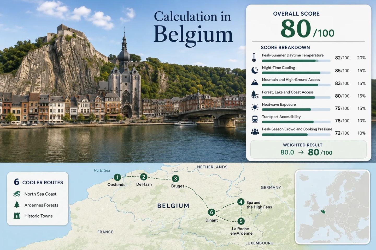
From the North Sea to the Ardennes Plateau
The markers connect Belgium’s maritime corridor with wooded Walloon valleys and rail-served historic towns. The western group benefits from North Sea air and frequent public transport; the southeastern group relies more on forest cover, cooler nights and short transfers into higher terrain.
Markers indicate route bases and planning centres rather than exact viewpoints, trailheads or legal parking positions. Use the destination links and official access information before travelling.
Belgium Mild-Summer Escape Suitability Score
This transparent editorial suitability index uses disclosed climate, landscape, access and visitor-pressure factors. It is not an official climate classification, personal comfort guarantee or weather forecast.
Weighted total: 95×0.25 + 100×0.20 + 15×0.15 + 100×0.15 + 78×0.10 + 90×0.10 + 50×0.05 = 80.3 → 80/100
Method: Route count does not create bonus points. Each route carries equal weight, route-level values are combined with the median, and the seven fixed factors retain their standard weights.
Coastal Air, Forested Valleys and Historic Bases
The route set is intentionally mixed. Oostende and De Haan provide immediate sea exposure, Bruges combines urban heritage with coastal access, Spa reaches the High Fens, and the Ourthe and Meuse valleys provide shaded alternatives for days when open coastal promenades or stone city centres feel too exposed.
Oostende: Direct Rail Access to North Sea Air
Oostende is the most straightforward sea-air base in the set. The railway terminus, harbour, beach and Coastal Tram are concentrated within a compact urban corridor, allowing a visitor to move between exposed waterfront areas and indoor city facilities without a car.
The KMI normal records 9.3 days with at least 1 mm of rain in July and 9.7 in August. Wind and fast-moving cloud can lower perceived warmth, but exposed promenades may feel cool rather than merely mild during strong onshore flow.
De Haan: Dunes, Woodland and a Tram-Based Coast Stay
Sea air is only part of the cooling pattern. De Haan also offers wooded residential streets and dune environments that provide more shade than the open waterfront. Its July–August maximum averages about 22.1°C, with an average minimum near 13.5°C.
There is no mainline railway station in the town. The official access pattern is train to Oostende or Blankenberge, followed by the Coastal Tram, which runs every 10, 15 or 20 minutes during the day depending on the period and every 30 minutes in the evening.
Bruges: Historic Streets With a Short Coastal Exit
Bruges is the warmest of the three West Flemish bases assessed, although its July–August daytime normal remains moderate. The compact stone centre can retain more warmth than Oostende’s waterfront, so the practical advantage is not constant sea breeze but the ability to combine early city walks with an afternoon rail or tram connection toward the coast.
The 1991–2020 normal records 3.2 July–August days reaching at least 30°C. The city’s larger constraint is visitor density: official 2024 figures report eight million day and overnight visitors in the historic centre and acknowledge crowd pressure at particular times and places.
Spa and the High Fens: Rail Base With Plateau Access
The Spa municipal normal produces the lowest July–August daytime value in the route set at approximately 21.4°C. Average minimum temperatures are about 12.5°C, and July and August each record roughly 12 days with at least 1 mm of rain.
The climate figures represent Spa’s accommodation base rather than the higher plateau. Signal de Botrange and the Nature Park Centre require an onward bus or road transfer, while some protected sections have access restrictions and route closures.
La Roche-en-Ardenne: Ourthe Valley Nights and Immediate Forest
La Roche-en-Ardenne combines a compact historic centre with steep wooded slopes rising directly from the Ourthe Valley. The route’s average July–August maximum is about 21.8°C, while the average minimum drops to approximately 11.5°C, the lowest night value in the set.
July averages 11.5 days with at least 1 mm of precipitation and August 11.7, so forest shade comes with a meaningful wet-weather trade-off. The Deister Hill woodland can be reached from town on foot, by car or by the local tourist train.
Regional buses serve the town, but there is no central mainline railway station. Evening returns and outlying trailheads require more timetable discipline than Spa or Dinant.
Dinant: Meuse Breezes, Limestone Slopes and Direct Rail
Dinant has the warmest daytime profile in the assessed group: July and August daily maxima average about 23.3°C. Nights still cool to roughly 12.0°C, creating a larger day-to-night change than at the coast.
The practical summer pattern is to use the shaded river corridor and wooded slopes during the warmest hours, then return to the compact riverside centre later in the day. The station includes connecting buses, while several principal sights sit within walking distance.
Which Belgian Base Matches the Cooling Priority?
The same route can perform differently depending on whether the priority is low daytime heat, cooler sleep, car-light access, forest shade or historic-town convenience. All six mapped and scored routes appear in the comparison.
| Route | July–August Max | Average Minimum | Primary Cooling Mechanism | Car-Light Access | Main Pressure or Weather Trade-Off |
|---|---|---|---|---|---|
| Oostende | 21.7°C | 13.3°C | North Sea wind and exposed waterfront | Strong: direct rail and Coastal Tram | Sunny-weekend crowds and wind exposure |
| De Haan | 22.1°C | 13.5°C | Sea air, dunes and wooded streets | Strong after one train-to-tram transfer | Summer accommodation demand and no mainline station |
| Bruges | 22.6°C | 13.6°C | Moderate maritime climate with coastal exit | Strong: direct rail | Historic-centre crowd density and warm stone streets |
| Spa and the High Fens | 21.4°C | 12.5°C | Forest, plateau exposure and higher terrain | Moderate: rail base plus bus or road transfer | Frequent rain and High Fens capacity controls |
| La Roche-en-Ardenne | 21.8°C | 11.5°C | Forest shade and strong night cooling | Moderate to limited: regional bus connections | Wet-weather frequency and trailhead logistics |
| Dinant | 23.3°C | 12.0°C | Meuse corridor and cooler nights | Strong: direct rail and local buses | Warmer afternoons in the enclosed river valley |
Why the Belgian Coast and Ardennes Cool Differently
North Sea Moderation Limits Daytime Peaks
Oostende and De Haan remain close to 22°C for average July–August maxima. Their nights are not the coolest in the route set, but onshore wind, exposed beaches and frequent cloud changes can reduce daytime heat accumulation.
The trade-off is exposure. A windy 20°C coastal day can require an extra layer, while a sheltered promenade or inland street may feel substantially warmer.
Ardennes Valleys Release Heat More Quickly at Night
La Roche-en-Ardenne averages about 11.5°C overnight in July–August, roughly two degrees below the assessed coastal bases. Spa and Dinant also remain within the full night-cooling score band.
Forested slopes reduce direct solar exposure, but the same geography increases rain frequency and can restrict daylight on narrow valley walks.
The Meuse Valley Has the Largest Afternoon Trade-Off
Dinant’s river and wooded slopes provide cooling options, yet its July–August daytime maximum is 23.3°C and its 30°C threshold frequency is the highest in the route set.
The route works more reliably when riverside walks, citadel visits and exposed viewpoints are separated by shaded or indoor periods rather than treated as one continuous midday itinerary.
The Coastal Tram Turns Sea Air Into a Car-Light Corridor
The Belgian coast has an unusual mobility advantage: the Coastal Tram links the seaside settlements while Oostende, Blankenberge and other coastal gateways connect with the national rail network. De Lijn publishes daytime intervals of 10, 15 or 20 minutes depending on the operating period, followed by 30-minute evening service.
Oostende Requires No Coastal Transfer
The railway, tram and waterfront converge around the same urban zone. This makes Oostende suitable for a flexible weather plan in which a windy beach period can be exchanged for harbour, museum or city time without returning to a parked vehicle.
De Haan Depends on the Final Tram Leg
Official local information directs rail passengers through Oostende or Blankenberge before transferring to the Coastal Tram. Late-evening plans should therefore account for both the train connection and the reduced evening tram interval.
Bruges Works as an Inland Heritage Base
Bruges is not a sea-breeze destination in the same sense as Oostende, but the direct rail network makes a split city-and-coast stay practical. This matters during short warm spells when an afternoon by the North Sea may be more comfortable than additional time in the historic centre.
Service check: Infrastructure work, events and sunny-weather demand can change travel times. Use the live De Lijn and SNCB planners rather than relying on a static departure assumption.
Spa Is the Rail Base, but the High Fens Need an Access Check
Spa offers the route set’s lowest July–August daytime normal and a railway station, yet the plateau experience lies beyond the town. Reaching Signal de Botrange, Baraque Michel or other High Fens starting points normally requires a bus, bicycle or road transfer.
The Traffic-Light System Can Change the Day Plan
The official High Fens access system uses green, orange, red and dark-red statuses. Orange indicates heavy visitor pressure, red means full capacity with no additional admissions, and dark red can involve closure and road diversion.
A red status is not merely a parking inconvenience. It is a signal to use an alternative East Belgium route rather than continuing toward the same entrance.
Protected Zones and Hunting Dates Affect Trail Choice
Some reserve zones have restricted access, and the official route planner displays hunting dates and temporary closures. Dogs are not permitted on paths crossing certain protected sections, while alternative routes may be indicated at the trail entrance.
Wet boardwalks, peatland conditions and rapid cloud changes also make waterproof footwear more useful here than the moderate monthly temperature alone might suggest.
Three Belgian Summer Windows for Different Priorities
June for Longer Days and Lower Peak Pressure
June daytime maxima are lower than July–August across all six municipal climate records. Coastal and historic-town stays gain long daylight, while the High Fens and Ardennes remain green but carry a meaningful rain risk.
Works for: Rail itineraries, long walks and travellers prioritising lower visitor pressure over the warmest sea conditions.
July–August for the Full Route Network
This is the scored window and the period with the most dependable tourism and transport operation. It is also when coastal demand, central Bruges crowds and High Fens capacity pressure become most relevant.
Heat exposure remains moderate by broader European standards, but short 30°C episodes are possible in every assessed municipality.
September for Cooler Towns and Quieter Valleys
September average maxima fall to approximately 17.5°C in Oostende, 17.7°C in Spa, 17.7°C in La Roche-en-Ardenne and 19.4°C in Dinant. The trade-off is shorter daylight and a growing chance of unsettled weather.
This period suits walking and historic-town combinations more than a beach-centred stay.
Forecast rule: Municipal climate normals describe the long-term pattern, not the conditions for a specific trip. Recheck heat alerts, rain, wind, High Fens access status and live transport information shortly before departure.