Germany for Cooler City Breaks: Forest Regions, Lakes and Alpine Edges
Germany’s more convincing less-hot city breaks sit outside the warmest lowland metropolitan corridors. High Black Forest towns, Lake Constance, the Allgäu lake belt and rail-connected Alpine bases combine usable town centres with forest shade, water access, cooler nights and quick routes toward higher ground. Freiburg remains the warmest base in this group, while Titisee-Neustadt, Freudenstadt, Füssen and the Bavarian Alpine towns provide a clearer elevation advantage.
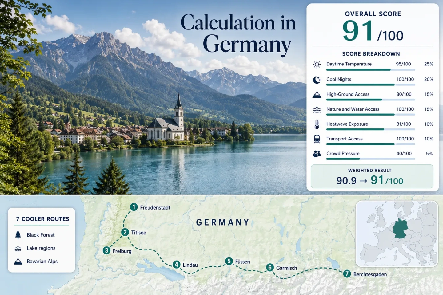
The same seven places are used in the marker map, score calculation, destination portfolio and comparison table.
Freiburg occupies the warm Rhine-rift edge; Titisee-Neustadt begins at a much higher Black Forest elevation.
A high town-and-lake setting produces the lowest July–August daytime proxy value in the assessed route set.
Mainline rail, local buses, a cogwheel railway and summer cable cars connect an urban base directly with high Alpine terrain.
Titisee, Lake Constance, Allgäu lakes, Eibsee and Königssee add swimming, shoreline or boat options without replacing heatwave checks.
Neuschwanstein tickets, popular lakefronts, mountain railways and national-park parking can create pressure during July and August.
Black Forest, Lake Constance and Bavarian Alpine Bases
The route set forms a south-German arc from the northern Black Forest to the Berchtesgaden Alps. It separates high forest towns from warmer valley cities and distinguishes lakeside cooling from direct access to Alpine height.
Markers show selected cooler-route regions and approximate public location centres, not guaranteed legal parking, trailheads or exact viewpoints. Use the Google Maps link and access note in each destination card before travelling.
Germany Forest, Lake and Alpine-Edge Suitability Score
This transparent editorial suitability index applies fixed climate, landscape, access and pressure factors to the seven displayed routes. It is not an official climate classification or a weather forecast.
Weighted total: 95×0.25 + 100×0.20 + 80×0.15 + 100×0.15 + 81×0.10 + 100×0.10 + 40×0.05 = 90.9 → 91/100
Method: Route count does not add bonus points. Each route has equal influence, and route-level values are combined by median before the fixed weights are applied.
High Forest Towns, Lake Bases and Alpine-Edge Cities
The route portfolio deliberately mixes compact urban services with fast access to shade, water or elevation. The warmest base can still work when its transport network reaches higher ground quickly; the coolest base may involve more rain, cloud and evening layers.
Freudenstadt
A high town rather than a low-valley gateway: Freudenstadt sits near 732 m, with extensive forest beginning close to the urban centre. The July–August route-centre proxy is about 21.5°C by day and 11.5°C at night, while the ten-summer proxy records 11 days at or above 30°C from 620 assessed days.
The town works for travellers who want restaurants, rail connections and short forest walks without beginning every outing with a long transfer. Higher sections of the Black Forest High Road require bus timetable checks or a car.
Titisee-Neustadt
The assessed base reaches roughly 846 m and combines Lake Titisee with high forest and rail access from Freiburg. Its proxy values are the lowest in this set: approximately 20.0°C for the July–August daily maximum and 10.5°C for the daily minimum.
Only 5 of 620 target-period proxy days reached 30°C, although the lakeshore promenade can feel much busier than the temperature data suggests. Neustadt provides a more functional town centre, while Titisee places visitors directly beside the water.
Freiburg im Breisgau
Freiburg supplies the strongest conventional city-break infrastructure in the route set, but its low base near 278 m lies beside one of Germany’s warmer corridors. The July–August proxy reaches approximately 25.5°C by day and 14.5°C at night, with 78 of 620 proxy days reaching at least 30°C.
The cooling value comes from mobility rather than the city centre alone. Trams, regional rail and buses make it possible to shift from the old town toward the Black Forest, Schauinsland approaches or higher Breisgau stations without changing accommodation.
Lindau (Bodensee)
Lake access is immediate, but the base is not alpine-cool. Lindau sits near 400 m and records route-centre proxies of about 24.0°C by day and 15.5°C at night. The ten-summer proxy count is 42 days at or above 30°C from 620 target days.
The water provides swimming, shoreline breezes and boat-based day trips, while rail services connect both the island and mainland. Access toward Pfänder and the Alpine foreland adds a vertical alternative when the lakeshore becomes warm.
Füssen
Füssen begins near 808 m, placing the old town above the lower Lake Constance and Rhine-rift bases before any mountain excursion starts. Its July–August proxy is approximately 22.0°C by day and 11.5°C at night, with 22 of 620 target-period days reaching 30°C.
Forggensee, Alpsee and the forested Allgäu foothills create several water-and-shade options. The railway terminus and local buses support a car-light stay, although trail choice expands with private transport.
Garmisch-Partenkirchen
Mainline rail arrives at a town base near 708 m. The route-centre proxy gives approximately 22.0°C for July–August daytime maxima and 11.0°C for minima; 26 of 620 assessed proxy days reached at least 30°C.
The defining advantage is vertical transport. The cogwheel railway, Zugspitze cable car, Gletscherbahn and Garmisch-Classic lifts provide scheduled access well above the town. Eibsee adds a lake option on the same transport axis.
Berchtesgaden
Berchtesgaden combines a compact town base near 572 m with Königssee, national-park forest and access toward Jenner. The assessed proxy values are approximately 22.5°C by day and 12.0°C at night; 24 of 620 target-period days reached 30°C.
Regional rail reaches the town, and buses serve Haus der Berge, Königssee and several walking areas. This makes the route usable without a car, particularly when accommodation includes a local guest transport benefit.
Freiburg’s Rhine-Rift Heat Versus the High Black Forest
Freiburg, Freudenstadt and Titisee-Neustadt should not be treated as interchangeable Black Forest bases. Their elevations, rail patterns and exposure to lowland heat create three different city-break strategies.
Freiburg as a Mobile Urban Base
Freiburg has the warmest daytime proxy and the highest 30°C exposure in the route set. Its value lies in frequent rail, tram and bus services that allow early departures toward Kirchzarten, Hinterzarten, Titisee and higher Black Forest terrain. Remaining exclusively in the old-town basin removes much of the cooler-escape logic.
Titisee-Neustadt Starts Higher
Titisee-Neustadt begins roughly 568 m above Freiburg’s assessed base. That elevation difference aligns with a daytime proxy around 5.5°C lower and substantially fewer 30°C days. The trade-off is a smaller urban offer, cooler wet-weather days and concentrated pressure around the Titisee waterfront.
Freudenstadt Balances Town and Forest
Freudenstadt lacks Titisee’s immediate large lake but provides a larger high-town centre surrounded by northern Black Forest terrain. It suits a rail-based break where forest access matters more than swimming and where the accommodation base itself should remain above 700 m.
Lake Constance Water Access and Allgäu Night Cooling
Lindau Favors the Swimming Window
Lindau’s lower elevation and larger water body support shoreline evenings, boat trips and summer swimming, but the route remains warmer overnight than the Allgäu bases. The lakeside setting is therefore more useful for water access than for consistently low daytime temperatures.
Decision signal: Choose Lindau when direct lake use, island architecture and international rail connections matter more than starting at a high elevation.
Füssen Favors Cooler Nights
Füssen stands roughly 400 m above Lindau and retains access to several lakes. Its proxy minimum is about 4°C lower, providing a stronger night-cooling pattern while keeping swimming, cycling and town services within the same stay.
Decision signal: Choose Füssen when sleep-time cooling and Alpine foothill access outweigh the broader Lake Constance transport-and-boat network.
Zugspitze and Jenner: Vertical Escape Without a Car
Garmisch-Partenkirchen and Berchtesgaden score strongly because their cooler terrain is connected to functional town bases by public transport rather than being accessible only through remote trailheads.
The Zugspitze Transport Axis
Garmisch-Partenkirchen station connects with the cogwheel railway toward Grainau, Eibsee and the Zugspitze plateau. Published summer operations also include the Zugspitze cable car, Gletscherbahn and several Garmisch-Classic lifts. This creates multiple altitude bands within one transport system.
Berchtesgaden’s Bus Gateways
Berchtesgaden uses a different pattern: regional rail reaches town, then RVO buses distribute visitors toward Königssee, Haus der Berge and other park gateways. National-park information warns that parking can be occupied on busy days, strengthening the case for bus-based planning.
Weather and Operating Limits
High transport does not guarantee a usable high-mountain day. Strong wind, thunderstorms, cloud, maintenance or timetable changes can restrict lifts and views. A lower forest or lake alternative should remain available when the summit plan becomes unsuitable.
Seven Bases Compared by Heat, Height and Access
Temperature values are rounded route-centre proxies rather than live forecasts. Public-transport ratings refer to reaching and using the main base; remote trailheads may still require limited services or additional planning.
| Route | Base elevation | July–August proxy | 30°C proxy frequency | Car-light strength | Main pressure point |
|---|---|---|---|---|---|
| Freudenstadt | About 732 m | 21.5°C max / 11.5°C min | 11 of 620 days | Rail base; buses useful for high-road sections | Weekend forest and scenic-road traffic |
| Titisee-Neustadt | About 846 m | 20.0°C max / 10.5°C min | 5 of 620 days | Direct regional rail from Freiburg | Titisee waterfront and parking concentration |
| Freiburg im Breisgau | About 278 m | 25.5°C max / 14.5°C min | 78 of 620 days | Major rail, tram and bus network | Lowland heat during hot spells |
| Lindau (Bodensee) | About 400 m | 24.0°C max / 15.5°C min | 42 of 620 days | Rail stations, buses and seasonal boats | Island accommodation and harbour pressure |
| Füssen | About 808 m | 22.0°C max / 11.5°C min | 22 of 620 days | Rail terminus with lake and castle buses | Timed castle tickets and gateway crowds |
| Garmisch-Partenkirchen | About 708 m | 22.0°C max / 11.0°C min | 26 of 620 days | Mainline rail, buses and mountain railways | Summit transport capacity and weather limits |
| Berchtesgaden | About 572 m | 22.5°C max / 12.0°C min | 24 of 620 days | Regional rail plus national-park buses | Busy parking, boats and park gateways |
Late June, Peak Summer and September Trade-Offs
The lowest-heat period, swimming period and broadest high-mountain access period do not fully overlap. Timing should follow the activity that matters most.
Late June for Forest and Long Days
Long daylight supports extended Black Forest walks and lake evenings before the main German school-holiday overlap reaches full intensity. High trails can still retain wet, damaged or late-snow conditions, so elevation access should be checked individually.
July–August for Broad Access
Mountain railways, boats and visitor services operate on their broadest summer schedules. This is also the period with the greatest heatwave exposure in Freiburg and Lindau and the strongest booking pressure around Titisee, Füssen, Zugspitze and Königssee.
September for Lower Pressure
Early September can retain usable lake and hiking conditions while reducing family-holiday pressure. Night temperatures fall faster at Titisee-Neustadt, Freudenstadt, Füssen and the Alpine bases, and some seasonal transport begins shortening later in the month.
Before departure: Check DWD warnings and short-range forecasts together with Deutsche Bahn disruption notices, mountain-railway operating pages, national-park access information, lake bathing notices and any timed attraction tickets. A cooler historical average does not remove thunderstorm, heatwave, föhn, flooding or high-wind risk.