Denmark for Mild Summer Travel: Islands, Coasts and Easy Breezy Cities
Denmark’s strongest mild-summer pattern comes from low, exposed coasts rather than altitude. Skagen, Fanø, Ærø, Bornholm and Læsø place sea air close to the accommodation base, while Copenhagen and Aarhus add direct rail, dense local transport and waterfront access. July and August can still produce hot spells, but the route set keeps wind, bathing water, shade and car-light alternatives within practical reach.
Two rail-first cities, one northern rail terminus and four island or ferry-linked routes.
Sea proximity, wind and modest night temperatures matter more than elevation.
Intercity rail, urban transit, cycling networks and nearby waterfronts reduce car dependence.
The exposed Skagen and Fanø mappings sit at the mild end of the shared station-normal set.
Vehicle space and the final return sailing can shape the day more than road distance.
Denmark scores through water access and transport, not mountain refuge during a heat burst.
From the North Sea Edge to Bornholm’s Rocky Coast
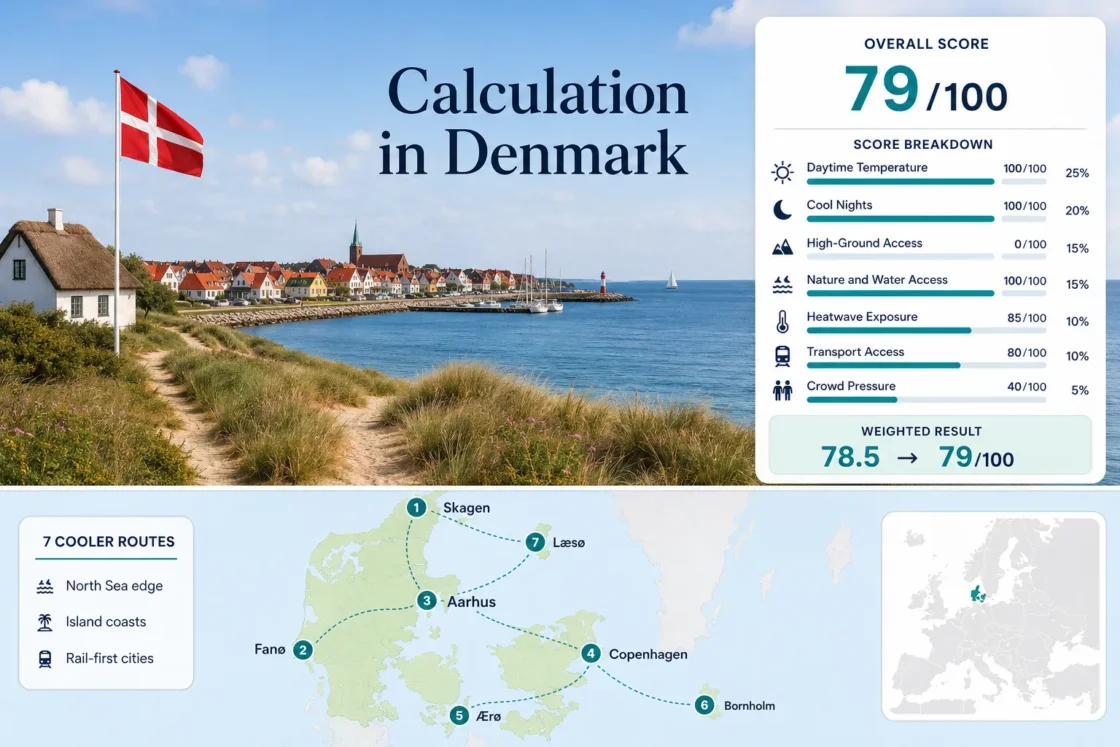
The markers connect breezy city bases, ferry islands and exposed coastal settlements across Denmark. The same seven places are used in the score, route profiles and comparison matrix.
This marker map is built for planning orientation. Marker positions use approximate public location centers where exact viewpoints, trailheads, legal parking areas or pull-offs are not specified. Markers show selected cooler-route regions, not guaranteed legal parking or exact navigation points.
Denmark Island-and-Coast Cooler Escape Suitability Score
This transparent editorial suitability index uses disclosed climate, landscape, access and pressure factors. It is not an official climate classification or a weather forecast. Older all-route station normals are retained for one comparable table, and the resulting data-quality grade is reduced accordingly.
Weighted total: 100×0.25 + 100×0.20 + 0×0.15 + 100×0.15 + 85×0.10 + 80×0.10 + 40×0.05 = 78.5 → 79/100
Method: Route count adds no bonus. Route-level values are combined by median before the seven fixed weights are applied. The C grade reflects representative stations, an older common normal period and the conservative heat-threshold proxy.
Island Harbours, Windward Coasts and Rail-First Cities
Each base offers a different way to manage summer warmth: exposed sea air, compact cycling, direct rail, forest shade or a ferry-defined island rhythm. The climate figures are the route mappings used in the score, not live forecasts.
Skagen and the Two-Sea Headland
Skagen places the accommodation base near the exposed tip of Jutland, with rail reaching the town and Grenen accessible by local road, cycle or visitor transport.
Skagen Fyr is the only direct station mapping in the northern route set. The coast can be windy even when inland North Jutland is warmer, while cloud and shower bands can change quickly around the headland.
Fanø Between the North Sea and Wadden Sea
A short ferry from Esbjerg reaches Nordby, after which buses, bicycles and the island’s compact scale can replace most driving.
The climate mapping uses exposed Thyborøn as a conservative North Sea analogue: 18.6°C for the July–August daytime maximum and 14.2°C at night. The mapping is distant, so the route carries a stronger comparability caution than Skagen or Copenhagen.
Aarhus Bay and Marselisborg Forest
Direct intercity rail and dense city buses make Aarhus the simplest west-of-Storebælt base in the set.
Tirstrup station represents the regional climate about 30 km northeast. Waterfront swimming areas and Marselisborg Forest create practical relief without leaving the city, while Mols Bjerge adds scenery rather than true high-altitude cooling.
The strongest use case is a rail-first trip with flexible city and forest options on the same day.
Copenhagen’s Harbour and Øresund Edge
The capital trades island isolation for the route set’s widest choice of rail, metro, harbour bathing areas and indoor alternatives.
Copenhagen Airport, about 8 km south of the centre, maps to 21.1°C by day and 12.8°C by night in the shared normal. Coastal neighbourhoods may receive more breeze than dense inner streets, so accommodation location matters during a warm spell.
Ærøskøbing and the South Funen Archipelago
Ærøskøbing is a low, ferry-defined island base where cycling, shore access and a compact town plan matter more than temperature differences within the island.
Odense Airport is the representative station and is roughly 70 km north, so the mapping is less direct than the island’s own marine setting. Ærøfærgerne serves Svendborg–Ærøskøbing and routes to Søby; the selected sailing determines onward bus and bicycle timing.
Allinge–Hammer Odde on Bornholm’s Rocky North
Bornholm combines a Baltic coast, granite headlands and access to Almindingen, giving this route more terrain variety than the western islands without meeting mountain thresholds.
The island-airport mapping gives 20.3°C by day and 13.4°C by night. The station lies about 25 km south, while the selected base is farther north near Hammeren and Hammer Odde.
Læsø’s Kattegat Air, Forest and Salt Meadows
Læsø is the slowest island transfer in the set: the Frederikshavn crossing takes about 90 minutes, with four to eight daily departures published for 2026.
Aalborg is the representative climate station about 65 km west and has more mainland influence, so it may overstate daytime warmth relative to an exposed Kattegat site. Forest, salt-meadow and beach access provide several low-intensity alternatives once on the island.
Seven Danish Bases Compared by Air, Water and Access
The temperature columns repeat the score mappings so that the trade-offs remain visible: the mildest mapped coast is not always the easiest arrival, and the strongest city transport does not create island-level exposure.
| Route | Jul–Aug max / min | Car-light arrival | Water or shade access | Main constraint |
|---|---|---|---|---|
| Skagen | 19.4°C / 13.1°C | Direct regional rail | Two coasts, dunes and plantation | Wind and exposed weather changes |
| Fanø | 18.6°C / 14.2°C proxy | Train to Esbjerg plus short ferry | North Sea and Wadden Sea | Vehicle queues and distant climate proxy |
| Aarhus | 21.0°C / 11.0°C | Direct intercity rail | Bay, harbour baths and Marselisborg Forest | Urban warmth away from the waterfront |
| Copenhagen | 21.1°C / 12.8°C | Rail, metro and buses | Harbour and Øresund | High demand and warm inner streets |
| Ærøskøbing | 21.4°C / 11.6°C proxy | Ferry plus island bus or bicycle | Archipelago coast | Sailing choice and limited vehicle space |
| Allinge–Hammer Odde | 20.3°C / 13.4°C | Ferry or flight plus bus | Baltic coast, cliffs and Bornholm forest | Peak accommodation and ferry pressure |
| Læsø | 20.6°C / 11.7°C proxy | Ferry plus limited local service | Coast, forest and salt meadows | 90-minute crossing and sparse connections |
Four Islands, Four Different Ferry Clocks
Fanø, Ærø, Bornholm and Læsø are not interchangeable island add-ons. Crossing length, vehicle handling and onward transport create four distinct planning patterns.
Fanø Works Like a Short Shuttle
Fanølinjen publishes a crossing of about 12 minutes between Esbjerg and Nordby and can add a third ferry when demand is high. Foot passengers can treat the crossing flexibly; drivers still need to allow for queues.
Ærø Has Three Mainland Gateways
Svendborg–Ærøskøbing, Faaborg–Søby and Fynshav–Søby create different onward journeys. Published crossings generally fall around 55–75 minutes, and the 2026 timetable includes date-specific cancellations and access notices.
Bornholm’s Fast Link Starts in Sweden
The Rønne–Ystad route takes about 80 minutes, but reaching Ystad is part of the real journey. Køge and Sassnitz alternatives have much longer sailing times, so route choice changes the practical day.
Læsø Requires a Longer Commitment
The official 2026 service lists a 90-minute crossing and four to eight daily departures. A bicycle can simplify island movement, but the last connection deserves more attention than on Fanø.
Skagen’s Two-Sea Exposure Versus Bornholm’s Baltic Delay
Skagen Responds Quickly to Wind
Skagen sits on a narrow headland between the North Sea and Kattegat. Wind direction can change whether the west or east side feels more sheltered, and the direct lighthouse station mapping places its July–August daytime normal at 19.4°C. The trade-off is exposure: a mild air temperature can still feel cool on an open beach.
Bornholm Holds More Stored Sea Warmth
Bornholm lies farther east in the Baltic, where seasonal sea warming can delay the shift into autumn. Its mapped nights are slightly milder than Aarhus or Ærø, while the island adds cliffs and forest rather than lower temperature alone. This supports walking and shade choices even when the coast is less wind-chilled than Skagen.
Copenhagen and Aarhus as Rail-First Cooling Bases
Copenhagen for Maximum Flexibility
Choose Copenhagen when the priority is car-free range: metro access from the airport, regional rail, harbour swimming areas and numerous indoor alternatives. Coastal districts improve breeze access, while central stone streets can retain more warmth after sunny afternoons.
Aarhus for a More Compact Balance
Choose Aarhus when a smaller urban base with immediate bay and forest access matters more than network scale. DSB publishes frequent intercity service between Copenhagen and Aarhus, and the city’s waterfront-to-forest distances are short enough to change plans without losing a full day.
Check Wind, Ferry Space and Bathing Conditions Before Departure
Use DMI for the current forecast and wind direction, Rejseplanen for same-day public transport, and the relevant ferry operator for vehicle space or service changes. Island crossings can be affected by operational notices, while urban harbour and beach plans should follow current local bathing-water and safety information. A mild historical normal does not remove short heat bursts, strong wind or cool-water risk.