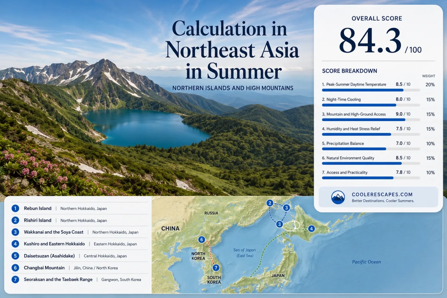
Northeast Asia in Summer: Northern Islands and High Mountains
Summer relief in Northeast Asia follows two different physical systems. Around northern Hokkaido, cold maritime exposure can hold daytime temperatures down even close to sea level. Farther south and inland, elevation becomes the stronger control: Daisetsuzan, Changbai Mountain, Seoraksan and the Daegwallyeong highlands gain cooler air by rising above warm lowlands. The trade-off changes with the mechanism—northern islands bring wind, fog and ferry dependence, while high mountains bring rapid weather changes, rain, cloud and steeper access.
Northern maritime air dominates the island belt; altitude becomes the stronger cooling control across the major mountain systems.
Japan's Ministry of the Environment records alpine vegetation beginning at sea level because of Rebun's cold climate and strong westerlies.
One compact volcanic island rises from a cool coast through forest belts to dwarf pine and alpine vegetation.
Daisetsuzan keeps large summit snowfields into midsummer, creating a much colder vertical environment above Hokkaido's inhabited basins.
JMA 1991–2020 mean temperatures for July and August at the 4 m coastal station show how strongly the Pacific side resists midsummer heating.
JMA recorded July 2026 mean temperature across Hokkaido at 1.7°C above the climatic normal, a reminder that northern latitude does not remove heat-wave risk.
Daily visitors topped 30,000 after the July 2026 summer rush began, according to a State Council Information Office report carried from Xinhua.
Two Cooling Belts Across Northeast Asia
The northern-island cluster runs from Rebun and Rishiri through Wakkanai to eastern Hokkaido. The high-ground cluster shifts inland and upward through Daisetsuzan, Changbai Mountain and Korea's Taebaek system. The markers show planning centers rather than exact viewpoints, trailheads or legal parking locations.
Marker positions use approximate public location centers. Use the named Google Maps link in each destination card together with current ferry, road, park and trail information before travel.
Northern Islands, Cold Coasts and High Mountain Bases
The eight areas are not interchangeable. Some deliver lower temperatures without climbing; others require a large elevation gain. Weather reliability, access and crowd pressure can matter as much as the thermometer.
Rebun Island: Alpine Conditions Without Alpine Elevation
Rebun is the clearest maritime-cooling case in the group. Japan's Ministry of the Environment attributes its windswept grasslands and alpine vegetation from 0 m above sea level to the island's cold climate and strong westerlies. The effect is ecological evidence that latitude, ocean exposure and wind can reproduce high-mountain conditions at very low elevation.
Those JMA normals use the shorter 2003–2020 Rebun record. August is warmer and wetter than July in the same series, so the island's lowest-heat period and its most settled-looking days do not necessarily coincide.
Rishiri Island: Maritime Cooling Plus a 1,721 m Mountain
Rishiri adds a second cooling mechanism to the Soya island climate. Mount Rishiri rises to 1,721 m on an island only about 60 km around, allowing a rapid shift from marine lowland air to alpine terrain.
At Kutsugata, JMA 1991–2020 normals put the average daily maximum at 21.4°C in July and 23.1°C in August, with average minima of 14.9°C and 16.6°C. The ecological transition is equally sharp: birch and alder belts become prominent above about 500 m, while dwarf pine and alpine flower fields appear above roughly 1,100 m.
The Ministry of the Environment lists June through September as the main Mount Rishiri season, with first summit snow around early October.
Wakkanai and the Soya Coast: Northern Latitude at Sea Level
Wakkanai shows how far northern latitude and marine exposure can work without a mountain base. The JMA station sits at about 3 m elevation near 45.4°N. Its 1991–2020 monthly mean is 17.2°C in July and 19.5°C in August.
Sea-level cooling is not a shield against short hot spells. Warm air can still push temperatures well above the monthly baseline, particularly when regional circulation overwhelms the normal maritime advantage.
Kushiro and Eastern Hokkaido: The Strong Coast–Interior Contrast
Kushiro's JMA station is only 4 m above sea level, yet its 1991–2020 mean temperature is 16.1°C in July and 18.2°C in August. Normal precipitation rises from 120.3 mm in July to 142.3 mm in August. The cool baseline comes with a maritime penalty: fog, low cloud and damp air can be more relevant than elevation.
Why it stands out: Eastern Hokkaido demonstrates that moving toward the exposed Pacific coast can reduce summer heat more reliably than simply moving a similar distance north inside the island.
Daisetsuzan and Asahidake: Hokkaido's High-Elevation Cooling
Asahidake reaches 2,291 m, the highest point in Hokkaido. Daisetsuzan's summit zone keeps large snowfields into midsummer, and the Ministry of the Environment describes the normal climbing period as late June through late September because first snow can arrive around mid-September.
The cooling advantage is therefore vertical rather than coastal. Lower valleys and gateway settlements can experience warm summer afternoons while high ground remains much colder, windier and more exposed.
Changbai Mountain: A Forest-to-Tundra Cooling Staircase
Official Jilin tourism material describes summer daytime temperature around the Changbai Mountains at about 22°C; it should be read as a regional tourism figure rather than a single-station climate normal. The stronger physical evidence is the mountain's vertical zoning.
Changbai's official protection authority places conifer forest roughly between 1,100 and 1,700 m, Erman's birch forest from about 1,700 to 2,000 m, and alpine tundra above 2,000 m. That sequence marks a rapid temperature and moisture change over a compact mountain area.
Seoraksan and Daecheongbong: High Relief Inside a Humid Summer
Daecheongbong rises to 1,708 m. Korea Tourism Organization information gives the shortest Osaek ascent at about four hours, while summer entry hours are listed as 03:00–14:00. The height produces real cooling, but it does not remove Korea's midsummer humidity, cloud or heavy-rain exposure.
Korea National Park Service reservation pages classify 1 July–31 August as peak season for Seoraksan shelters. Lower temperature and lower crowd pressure therefore do not peak at the same time.
Daegwallyeong Highlands: Cooling Begins at the Overnight Base
Daegwallyeong is a different Korean mountain model. The pass itself is about 832 m high and extends for roughly 13 km between the Gangneung and Pyeongchang sides. Korea Tourism Organization material describes the area as a high-level plateau with lower temperatures and strong wind compared with lower surrounding districts.
Because the accommodation and road network can already sit high on the Taebaek divide, cooling does not depend on reaching a 1,700 m summit. That makes the area more useful for overnight highland cooling than a summit-only itinerary.
Why Rebun Can Turn Alpine at Sea Level
Cold Air and Westerlies Replace Elevation
Alpine vegetation normally signals height because low temperature, wind exposure and a short growing season become stronger uphill. Rebun compresses those conditions down to the coast. Its cold maritime setting and persistent westerlies form exposed grasslands where alpine plants can occur from sea level.
The practical consequence is unusual: a traveler can obtain a strongly cool, wind-exposed summer environment without a long ascent. Temperature relief is available at walking-route elevation, but the price can be fog, low cloud and wind chill.
Rishiri Adds Altitude to the Same Maritime Air
Rishiri starts in the same northern marine setting, then stacks 1,721 m of relief on top of it. The Ministry of the Environment records a clear vegetation progression from coastal mixed forest to birch and alder above about 500 m, then dwarf pine and alpine flower fields above roughly 1,100 m.
That makes Rishiri one of the few places in the region where maritime cooling and elevation cooling can be compared on a single island. It also explains why summit conditions should never be inferred from the harbor forecast alone.
Eastern Hokkaido's Coast–Interior Split Is the Heat-Wave Test
Kushiro's long-term July and August means remain low, but Hokkaido as a whole is not heat-proof. JMA's regional anomaly table shows July 2026 averaging 1.7°C above normal across Hokkaido. One year earlier, Obihiro in the Tokachi interior reached 38.8°C on 24 July 2025.
A northern latitude is not a heat guarantee. Coastal exposure can keep Kushiro, Nemuro and parts of the Soya coast much milder than inland basins on the same broad island. When unusually warm air masses arrive, inland Hokkaido can heat rapidly while the cold-coast advantage remains stronger near the sea.
The useful comparison is therefore not “Hokkaido versus southern Japan.” It is exposed coast versus inland basin versus high mountain. Kushiro represents marine resistance to daytime heating; Tokachi shows how quickly that protection weakens inland; Daisetsuzan restores cooling by gaining elevation.
Changbai and Seoraksan Trade Heat for Cloud, Rain and Capacity
Mountain cooling in China and Korea sits inside a more humid midsummer circulation than the Soya islands. At Changbai, climbing through forest, birch and tundra zones lowers temperature, but summit visibility can disappear in cloud, wind and rain. A cool Tianchi day is not automatically a clear Tianchi day.
Seoraksan has the same planning tension in a Korean monsoon setting. Daecheongbong is high enough for a strong vertical temperature drop, yet July and August also bring humid air, heavy-rain episodes and peak-season pressure. The national park's early summer entry window reflects the length and exposure of the higher routes rather than a promise of stable afternoon weather.
Island Cooling Versus High-Mountain Cooling
The useful distinction is not simply north versus south. It is the physical source of the cooling and the conditions that can weaken it.
| Area | Main cooling mechanism | Physical marker | July–August character | Main trade-off |
|---|---|---|---|---|
| Rebun Island | Cold maritime air + wind | Alpine vegetation from 0 m | Low daytime maxima even at sea level | Wind, fog and ferry dependence |
| Rishiri Island | Maritime air + elevation | 1,721 m island peak | Cool coast with a much colder upper mountain | Large vertical weather change |
| Wakkanai and the Soya Coast | Latitude + marine exposure | JMA station near sea level at 45.4°N | Monthly means remain in the high teens | Short warm spells still occur |
| Kushiro and Eastern Hokkaido Coast | Pacific maritime cooling | 16.1°C July mean at 4 m station | Very mild baseline compared with inland Hokkaido | Fog, cloud and dampness |
| Daisetsuzan and Asahidake | High elevation | 2,291 m summit; midsummer snowfields | Strong cooling with height | Snow, wind and rapid mountain weather |
| Changbai Mountain | Elevation + forest belts | Alpine tundra above about 2,000 m | Cool high ground inside a wet summer regime | Cloud, rain and heavy visitor pressure |
| Seoraksan and Daecheongbong | Steep elevation gain | 1,708 m summit | Cooler upper mountain within humid monsoon air | Long climbs, rain and peak-season demand |
| Daegwallyeong Highlands | High overnight base + mountain divide | 832 m pass and high-level plateau | Cooling begins before summit hiking | Wind, cloud and summer rain |
July and August Shift the Cooling Trade-Off
Soya Islands: July Is Cooler, August Is Wetter and Warmer
Rebun's normal maximum rises from 20.4°C in July to 22.6°C in August, while normal precipitation rises from 101.0 mm to 138.6 mm. Rishiri's Kutsugata maximum similarly rises from 21.4°C to 23.1°C. July therefore has the stronger low-heat signal, although day-to-day wind and cloud remain decisive.
Daisetsuzan: A Short High-Mountain Summer
Large snowfields can remain through midsummer, yet first summit snow may return around mid-September. The usable high-mountain window is compressed between late snowmelt and early autumn conditions, making elevation a powerful but seasonally narrow cooling tool.
Changbai: Cool Air Meets Peak Summer Demand
July and August deliver the heat-avoidance conditions that draw visitors from warmer lowlands, but they also overlap with cloudier mountain weather and the strongest visitor pressure. The 2026 rush passed 30,000 visitors per day after July began.
Korean Highlands: Elevation Does Not Cancel Monsoon Weather
Seoraksan and Daegwallyeong remain cooler than low elevations because of height, but midsummer planning still has to account for humidity, heavy rain and trail controls. High bases such as Daegwallyeong offer cooling without a summit ascent; Seoraksan gives a larger vertical drop with more weather and access exposure.