South Korea Heat Escape Routes: Mountain Parks, Forest Valleys and Cooler Resorts
South Korea’s most credible summer relief comes from the Baekdudaegan mountain spine rather than from a simple move north. High lodging bases around Daegwallyeong and Taebaek, forested national-park valleys, and lift-served resort ridges can reduce daytime heat or restore cooler nights, although July monsoon rain, humid valley air and weekend access pressure remain central planning constraints.
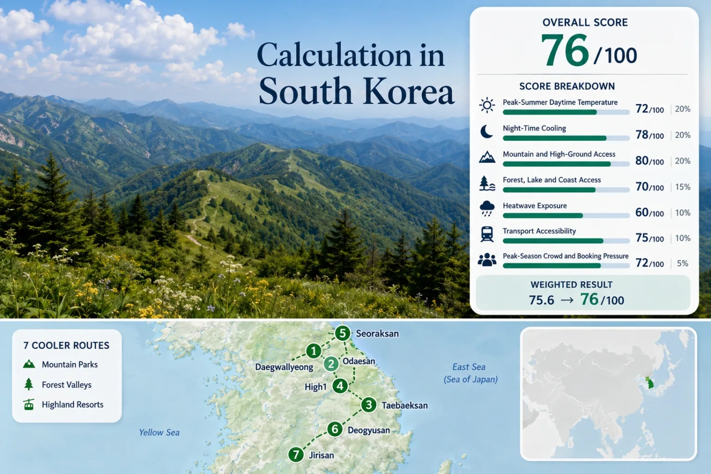
The same seven places appear in the map, score evidence, route portfolio and primary comparison.
Daegwallyeong’s representative July–August average maximum is the coolest value in the assessed set.
The route-set median favors highland sleep, while southern low-elevation gateways remain warmer overnight.
A 700–900 m lodging belt and cable-car access toward 1,458 m create the clearest low-heat resort pattern.
KTX or conventional rail reaches the strongest Gangwon highland bases, but local timetables still shape park access.
High terrain improves temperature but also raises exposure to heavy rain, cloud, trail closures and rapid visibility changes.
Baekdudaegan Parks, Highland Resorts and Eastern Valleys
The route field follows South Korea’s mountain spine from Gangwon resort country to the southern national parks. Markers indicate planning centers rather than exact trailheads, viewpoints, legal parking spaces or lodging entrances.
Markers show selected cooler-route regions and approximate public location centers. Use the place-specific Google Maps links and current park access information before traveling.
South Korea Mountain-Park Cooler Escape Suitability Score
This transparent editorial suitability index uses disclosed climate, landscape, access and pressure factors. It is not an official climate classification or a weather forecast. Every route carries equal weight, and route count creates no score bonus.
Method: July and August average daily maximum temperatures from Korea Meteorological Administration 1991–2020 normals; route median normalized with the fixed daytime-temperature scale.
Raw: Median 26.0°C, producing 65/100 by linear interpolation between 25°C and 27°C.
Route values: Daegwallyeong–Balwangsan 23.5°C; Odaesan–Woljeongsa 23.5°C; Taebaeksan–Taebaek 26.0°C; High1–Baegunsan 26.0°C; Seoraksan–Inje 28.5°C; Deogyusan–Muju 27.4°C; Jirisan–Sancheong 29.2°C. Median: 26.0°C.
Source mapping: Daegwallyeong–Balwangsan and Odaesan–Woljeongsa — Daegwallyeong station 100, representative for the Pyeongchang highland belt; Odaesan’s forest road and peaks extend higher than the station. Taebaeksan–Taebaek — Taebaek station 216, direct urban highland station. High1–Baegunsan — Taebaek station 216, representative for the adjoining highland zone; the 1,340 m resort ridge is higher and no lapse-rate correction was applied. Seoraksan–Inje — Inje station 211, representative for western approach valleys about 25–35 km from principal trail areas and substantially lower than upper slopes. Deogyusan–Muju — Jangsu station 248, representative for the inland highland climate about 25–35 km from the resort zone and lower than lift-served terrain. Jirisan–Sancheong — Sancheong station 289, direct regional base station but much lower than Jirisan ridges.
Period: 1991–2020 climate normals; July–August mean of published monthly values.
Sources: KMA 1991–2020 climate normals tables; KMA Gangwon regional climate statistics; Taebaek municipal climate summary using KMA normals.
Method: July–August mean daily minimum from the same official normal tables and station mapping used for daytime temperature.
Raw: Median 17.8°C. The fixed scale gives 85/100 at 18°C and 100/100 at 16°C; linear interpolation gives 86.5, rounded to 87/100.
Route values: Daegwallyeong–Balwangsan 17.4°C; Odaesan–Woljeongsa 17.4°C; Taebaeksan–Taebaek 17.8°C; High1–Baegunsan 17.8°C; Seoraksan–Inje 20.2°C; Deogyusan–Muju 20.1°C; Jirisan–Sancheong 21.3°C. Median: 17.8°C.
Source mapping: Station IDs, mapping type, distance rationale and altitude limitations are identical to the daytime factor. Resort summits and upper trails were not assigned colder synthetic values.
Period: 1991–2020 climate normals; July–August mean of published monthly minimum temperatures.
Sources: KMA 30-year averages data interface; KMA national normals tables.
Method: Fixed categorical rubric based on lodging-base elevation and regular access to meaningful higher terrain within the route system.
Raw: Route-score median 80/100.
Route scores: Daegwallyeong–Balwangsan 80 — highland lodging belt around 700–900 m and cable-car access toward 1,458 m; Odaesan–Woljeongsa 80 — high base area with direct access to the 1,563 m Birobong trail system; Taebaeksan–Taebaek 80 — city base above 600 m with nearby high slopes; High1–Baegunsan 80 — highland rail towns and resort terrain reaching about 1,340 m; Seoraksan–Inje 60 — low-to-middle valley bases with rapid elevation gain but longer high-trail access; Deogyusan–Muju 100 — resort lift access reaches Seolcheonbong above 1,500 m; Jirisan–Sancheong 60 — low valley bases and high ridges reached mainly by sustained hiking. Median: 80/100.
Route rationale: Scores measure usable access rather than peak height alone. A 1,900 m summit does not receive a high score when the usual sleeping base is low and the upper terrain requires a long ascent.
Period: Access status reviewed July 15, 2026.
Sources: Balwangsan cable car and 1,458 m summit information; Odaesan and Birobong access; High1 resort elevation and station shuttle information; Jirisan Sancheong terrain.
Method: Fixed rubric measuring physical access to extensive forest, a major water system or the coast, not scenery quality.
Raw: Route-score median 75/100.
Route scores: Daegwallyeong–Balwangsan 75 — extensive mountain forest within 30 minutes; Odaesan–Woljeongsa 75 — dense forest and the Odaecheon corridor, counted as one strong combined forest system; Taebaeksan–Taebaek 75 — national-park forest immediately accessible; High1–Baegunsan 75 — broad forested resort slopes; Seoraksan–Inje 100 — extensive mountain forest plus East Sea coast access from the Sokcho side; Deogyusan–Muju 75 — national-park forest and Gucheon-dong valley treated as one strong system; Jirisan–Sancheong 75 — extensive forest and tributary valleys treated as one strong system. Median: 75/100.
Route rationale: Small streams inside a forest were not automatically counted as a second major water element, preventing double credit for one landscape system.
Period: Physical access reviewed July 15, 2026.
Sources: Odaesan Seonjaegil forest and Odaecheon corridor; Seoraksan outer district access; Deogyusan resort and Gucheon-dong valley setting; Jirisan Chilseong Valley access context.
Method: Official threshold-frequency fallback using KMA station climatological frequency of July–August days reaching 30°C or more. Exact ten-summer daily counts were not claimed because a uniform route-level daily extraction was not available for every representative station.
Raw: Median threshold frequency 3.0%. The fixed scale gives 90/100 at 2% and 75/100 at 5%; linear interpolation gives 85/100.
Route values: Daegwallyeong–Balwangsan 1.0%; Odaesan–Woljeongsa 1.0%; Taebaeksan–Taebaek 3.0%; High1–Baegunsan 3.0%; Seoraksan–Inje 10.0%; Deogyusan–Muju 8.0%; Jirisan–Sancheong 18.0%. Median: 3.0%.
Source mapping: Daegwallyeong station 100 for routes 1–2; Taebaek station 216 for routes 3–4; Inje station 211 for route 5; Jangsu station 248 for route 6; Sancheong station 289 for route 7. The same representative-station limitations described in the temperature factors apply.
Period: Station climatological threshold-frequency tables associated with the official normals interface; July–August target months.
Sources: KMA Open MET Data Portal; KMA daily past-observation interface for current verification.
Method: Fixed rubric based on direct rail or bus access, transfer count, journey complexity and need for a private vehicle.
Raw: Route-score median 80/100.
Route scores: Daegwallyeong–Balwangsan 80 — KTX to Jinbu followed by resort shuttle, bus or taxi; Odaesan–Woljeongsa 80 — KTX or intercity access to Jinbu plus local bus 55; Taebaeksan–Taebaek 100 — rail or intercity bus to Taebaek with local transit to park approaches; High1–Baegunsan 80 — rail to Gohan or Sabuk plus resort shuttle; Seoraksan–Inje 100 — intercity bus to Sokcho or Inje with established local park buses; Deogyusan–Muju 60 — intercity transfer and more limited local resort or park connections; Jirisan–Sancheong 60 — regional bus access, with dispersed valleys and trailheads increasing local complexity. Median: 80/100.
Route rationale: A rail station in the wider county did not automatically create a direct-access score; the final local connection remained part of the rating.
Period: Timetable and access structure reviewed July 15, 2026; seasonal services require reconfirmation.
Sources: KORAIL booking and timetable interface; Jinbu–Odaesan local bus access; High1 station shuttle information; Seoraksan visitor access information.
Method: Fixed categorical fallback using official reservation systems, campground peak-season dates, parking surcharges, capacity controls and park-entry notices where comparable accommodation occupancy was unavailable.
Raw: Route-score median 60/100.
Route scores: Daegwallyeong–Balwangsan 60 — weekend resort demand and weather-dependent lift capacity; Odaesan–Woljeongsa 60 — regular summer parking pressure at principal temple and trail access points; Taebaeksan–Taebaek 80 — weekend concentration without broad reservation dependence; High1–Baegunsan 60 — resort inventory helps capacity but peak weekends tighten popular stays; Seoraksan–Inje 40 — established peak parking surcharges, early entry cutoffs and campground reservation pressure; Deogyusan–Muju 60 — resort concentration and lift capacity produce recurring busy periods; Jirisan–Sancheong 40 — shelter, campground and selected facility reservations combine with constrained valley access. Median: 60/100.
Route rationale: The score measures planning friction, not popularity. Early starts and reserved facilities matter more than total annual visitor counts.
Period: Current reservation and access rules reviewed July 15, 2026.
Sources: Korea National Park Service reservation system; Seoraksan campground peak-season service information; Seoraksan summer entry and parking information; Jirisan valley parking context.
Weighted total: 65×0.25 + 87×0.20 + 80×0.15 + 75×0.15 + 85×0.10 + 80×0.10 + 60×0.05 = 76.4 → 76/100
High Passes, Park Valleys and Resort Bases
The portfolio separates places where visitors can sleep high from parks where cool upper terrain is reached only after a warm valley start. Representative station figures describe the route base or regional approach, not a summit microclimate.
Daegwallyeong–Balwangsan, Pyeongchang
Sleeping high is the advantage. The Daegwallyeong plateau supports lodging and resort infrastructure around the 700–900 m band, while Balwangsan cable-car access rises toward 1,458 m in roughly 18 minutes one way.
Cloud, wind and lift suspension can erase the planned summit day, but the high lodging base still preserves a stronger night-cooling pattern than lowland cities. Weekends concentrate demand around resort complexes and ranch attractions.
Odaesan–Woljeongsa, Pyeongchang
A 9 km forest road follows the Odaecheon corridor, and the Woljeongsa needle-fir area creates continuous shade before higher routes turn toward Birobong at 1,563 m. The representative highland normal is 23.5°C by day and 17.4°C at night.
Car-light access is unusually workable for a national-park forest route: KTX reaches Jinbu, and local bus 55 links the station or intercity terminal with the Odaesan entrance. Service frequency matters more than total road distance.
Taebaeksan–Taebaek, Gangwon
Taebaek functions as a genuine highland city base rather than a warm gateway with a distant mountain excursion. Its July–August representative daytime maximum is about 26.0°C, nights average about 17.8°C, and the urban base sits above 600 m.
Local buses and taxis shorten the final approach to Taebaeksan. The mountain is less dependent on resort operating calendars than lift-based routes, but summer cloud and rain can obscure ridgeline plans.
Good for: Travelers who want cooler lodging, ordinary city services and a rail-accessible mountain base without relying on one cable car.
High1–Baegunsan, Jeongseon
Gohan and Sabuk provide rail-linked highland bases, while High1’s resort terrain reaches roughly 1,340 m on Baegunsan. Taebaek station is used as the representative climate station: 26.0°C daytime and 17.8°C night normals, with no artificial cooling adjustment for the higher ridge.
The resort shuttle reduces car dependence from Gohan or Sabuk station. Outside scheduled resort service, dispersed trail and attraction access becomes less convenient, so timetable checking is a core part of the route.
Seoraksan–Inje
Seoraksan offers the widest landscape contrast in the set: steep forest, high granite terrain and East Sea access from the Sokcho side. The trade-off is a warmer representative valley normal—28.5°C daytime and 20.2°C at night—before elevation gain begins.
Official summer entry windows can begin before dawn and close to new hikers in the afternoon. This makes Seoraksan a start-early mountain day, not a guarantee of cool lodging at the valley edge.
Deogyusan–Muju Resort Corridor
Deogyusan combines the Gucheon-dong valley with lift-served access to Seolcheonbong above 1,500 m. That vertical access earns the strongest high-ground rubric result in the portfolio, even though the representative Jangsu-station base normal remains 27.4°C by day and 20.1°C at night.
Intercity access reaches Muju, but the final resort and park movements are less seamless than Gangwon’s rail-linked bases. A private vehicle or confirmed local transfer materially improves flexibility.
Jirisan–Sancheong Forest Valleys
Jirisan reaches 1,915 m at Cheonwangbong, yet the normal visitor experience often begins in warm, humid southern valleys. Sancheong’s representative base values—29.2°C daytime and 21.3°C at night—show why peak height alone does not equal a cool sleeping base.
Works for: Strong hikers who can gain elevation early and treat forest shade, stream valleys and upper ridges as daytime relief rather than expecting resort-style cool air.
Rainfall can quickly alter valley safety, and shelters, campgrounds or selected facilities may require advance booking through the national-park reservation system.
Baekdudaegan Altitude Bands: Sleep High or Climb from a Valley
South Korea’s mountain routes divide into two operationally different groups. The distinction changes comfort more than summit elevation printed on a park map.
Daegwallyeong, Taebaek and Gohan Keep the Night Advantage
These bases start around the highland city or plateau belt. Representative night normals cluster near 17–18°C, and ordinary services remain available without descending to a major lowland city. Daegwallyeong adds the strongest resort inventory; Taebaek adds the most independent city structure; Gohan and Sabuk add rail-linked access to High1.
Seoraksan, Deogyusan and Jirisan Need Earlier Elevation Gain
These systems contain very high terrain, but representative approach temperatures remain warmer. A late start can leave most of the day in humid valleys, while early entry, lift operation or a sustained climb is required to reach the cooler band. Jirisan shows the contrast most clearly: a 1,915 m summit paired with a 21.3°C representative night normal at the Sancheong base.
Odaesan Sits Between Resort Height and Park-Forest Access
Odaesan uses the Daegwallyeong highland climate signal but operates as a forest and temple corridor rather than a resort ridge. Jinbu KTX and bus 55 support a car-light plan, while the shaded Seonjaegil provides a lower-intensity fallback when cloud, rain or trail controls make Birobong impractical.
Jangma Rain, Valley Water and National-Park Entry Windows
July heat relief in the Korean mountains arrives with a serious rainfall trade-off. Daegwallyeong’s official regional climate summary records a large share of annual precipitation in summer, and steep valleys in Seoraksan, Odaesan, Deogyusan and Jirisan can move from shaded refuge to restricted terrain after intense rain.
Seoraksan Rewards a Pre-Dawn or Early-Morning Start
Official summer entry can open around 03:00 on selected routes and stop new entry in the afternoon. Early timing avoids part of the valley heat, protects turnaround time and reduces exposure to later convective weather.
Woljeongsa and Seonjaegil Provide a Lower-Commitment Option
The needle-fir road and 9 km Odaecheon forest corridor allow a shaded day without committing to a high summit. They remain subject to park controls, but the route design is better suited to uncertain cloud ceilings than an exposed ridge objective.
Jirisan and Deogyusan Need Same-Day Water Checks
Forest cover does not remove flash-flood or slippery-trail risk. Check national-park notices, rainfall radar and facility status before entering narrow valleys; a cool stream corridor is not an automatic wet-weather substitute.
KTX Highland Bases Versus Southern Park Transfers
Rail access is concentrated in the Gangwon highland group. The southern parks offer higher summits but require more attention to final-mile buses, resort transfers or private-vehicle logistics.
Jinbu Connects Odaesan and Daegwallyeong
Jinbu KTX can support a two-base itinerary: bus 55 toward Woljeongsa and Odaesan, then resort shuttle, bus or taxi toward Daegwallyeong and Balwangsan. The two systems share a broad highland climate but deliver different days—forest walking versus lift-assisted elevation.
Taebaek, Gohan and Sabuk Support a Slower Rail Pattern
Conventional rail and intercity services place travelers inside the mountain belt rather than at its edge. Taebaek is stronger for independent city-and-park travel; Gohan and Sabuk are stronger when High1’s current shuttle and facility calendar align.
Muju’s Lift Advantage Comes with a Transfer Penalty
Deogyusan’s upper access is unusually efficient once inside the resort, but reaching the resort from a major rail corridor is less direct. The itinerary works more reliably with a confirmed bus connection, resort transfer or car.
Sancheong’s Valleys Are More Dispersed Than One Map Pin Suggests
Jirisan’s eastern approaches include separate valleys, facilities and trailheads. A regional bus arrival does not settle the final movement, and reservation status may determine which valley can serve as the practical base.
Seven Routes by Temperature, Access and Main Constraint
Day and night figures are representative July–August station normals for the route base or regional approach. Higher trails and lift summits can be colder, but no manual altitude correction has been added.
| Route | Day / Night Normal | High-Ground Pattern | Car-Light Potential | Main Constraint |
|---|---|---|---|---|
| Daegwallyeong–Balwangsan | 23.5°C / 17.4°C | High lodging plus cable car toward 1,458 m | Strong via Jinbu with confirmed local link | Lift weather and weekend resort demand |
| Odaesan–Woljeongsa | 23.5°C / 17.4°C | Highland forest base and 1,563 m trail system | Strong via Jinbu and bus 55 | Rain closures and bus frequency |
| Taebaeksan–Taebaek | 26.0°C / 17.8°C | Highland city with nearby park slopes | Strong by rail, bus and local transit | Cloudy ridges and local timetable gaps |
| High1–Baegunsan | 26.0°C / 17.8°C | Rail towns below resort terrain to 1,340 m | Good when station shuttle operates | Seasonal facility and shuttle calendar |
| Seoraksan–Inje | 28.5°C / 20.2°C | Warm valley start with steep elevation gain | Strong from Sokcho or Inje buses | Early cutoffs, parking and reservations |
| Deogyusan–Muju | 27.4°C / 20.1°C | Lift access above 1,500 m from resort base | Moderate; final transfer needs planning | Gondola operation and humid lower terrain |
| Jirisan–Sancheong | 29.2°C / 21.3°C | Low valley base beneath very high ridges | Moderate; dispersed final approaches | Rain, reservations and long ascents |
Choosing the Summer Window by Travel Intent
For the Lowest Heat, Prioritize High Lodging Over a Famous Summit
Daegwallyeong, Taebaek and the Gohan–Sabuk belt retain the clearest night advantage. Their benefit continues after the day trip ends, unlike low valley bases where only the upper trail is cool.
For Rain Flexibility, Pair a Town Base with a Shaded Short Route
Taebaek city services and the Odaesan forest corridor allow easier plan changes than a shelter-dependent Jirisan itinerary. A wet day can be shortened without losing the entire highland stay.
For Car-Light Travel, Build Around Current Rail and Shuttle Times
Jinbu, Taebaek, Gohan and Sabuk are the strongest anchors. Book the long-distance train first, then verify the final local bus or resort shuttle before reserving a remote property.