Taiwan Mountain Cooldowns: Alishan Forests, High Roads and East Coast Air
Taiwan’s summer cooling pattern is vertical rather than regional. Alishan, Tataka, Hehuanshan, Lishan, Dasyueshan and Taipingshan trade lowland heat for elevation, forest cover and cooler nights, while Qixingtan and Sanxiantai add open Pacific air without removing tropical humidity. The most reliable temperature relief comes from sleeping high; the east coast works better for airflow, sea access and a less enclosed evening than for genuinely low daytime temperatures.
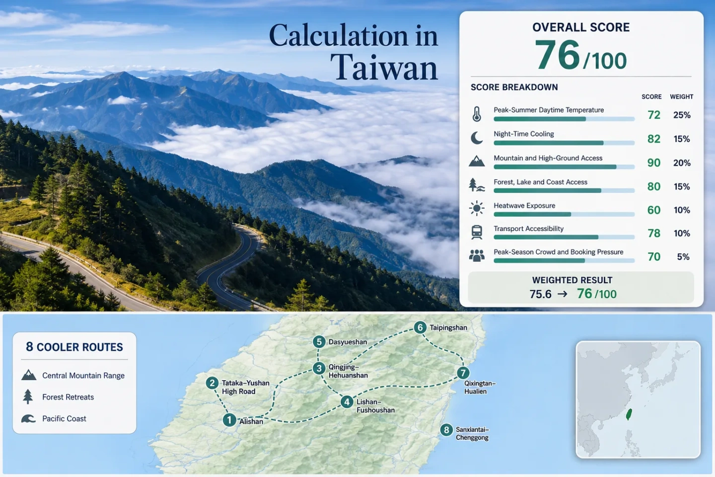
Six mountain or forest corridors and two Pacific coast bases form the same set used in the map, score and comparison matrix.
The period captures Taiwan’s strongest lowland heat while high roads remain broadly usable between weather disruptions.
At 2,413.4 metres, the official station’s 2011–2020 July–August mean maximum is about 19.1°C.
The visitor-centre junction on highways 18 and 21 reaches a much colder altitude band than Taiwan’s coastal cities.
This station-based median is pulled upward by the east coast and conservative lowland proxies used for high forest routes.
Mountain highways, forest roads and rail services can change after heavy rain, landslides or tropical-cyclone warnings.
Alishan, Central Range Roads and Pacific Planning Centers
The markers connect the route set from Alishan and the high Central Range to Yilan’s mountain forests and the east coast. They are orientation points rather than guaranteed viewpoints, legal parking spaces or trailheads.
This marker map is built for planning orientation. Positions use approximate public location centers where exact viewpoints, trailheads, legal parking areas or pull-offs are not specified. Use each route card for Google Maps links and current access checks before traveling.
Taiwan Mountain and East Coast Cooler Escape Suitability Score
This transparent editorial suitability index uses disclosed climate, landscape, access and pressure factors. It is not an official climate classification or a weather forecast. The score describes the eight listed routes, not Taiwan as a whole, and route count provides no score bonus.
Method: Median of each route’s July–August mean daily maximum, normalized with the fixed daytime-temperature scale.
Raw: Route-set median 28.6°C, producing 39/100 by linear interpolation between 27°C = 55 and 29°C = 35.
Route values: Alishan 19.1°C; Tataka–Yushan 14.6°C; Qingjing–Hehuanshan 28.6°C; Lishan–Fushoushan 28.6°C; Dasyueshan 28.6°C; Taipingshan 33.4°C; Qixingtan–Hualien 32.5°C; Sanxiantai–Chenggong 31.7°C. Median: 28.6°C.
Source mapping: Alishan — direct CWA Alishan station 467530 at 2,413.4 m, inside the route zone. Tataka — representative CWA Yushan station 467550, roughly 12 km away and about 1,235 m above the 2,610 m Tataka base, creating a cold-side proxy. Qingjing–Hehuanshan — representative CWA Sun Moon Lake station 467650 at 1,017.5 m, roughly 30 km away and materially below the lodging and high-road zones, creating a warm-side proxy. Lishan–Fushoushan — the same Sun Moon Lake station, roughly 55 km away and about 940 m below the Lishan guesthouse area. Dasyueshan — the same station, roughly 50 km away and about 1,000 m below the main recreation zone. Taipingshan — representative CWA Yilan station 467080, roughly 40 km away and about 1,900 m below the main area, creating a strong warm-side proxy. Qixingtan — direct or near-route CWA Hualien station 466990 within the Hualien coastal base. Sanxiantai — direct or near-route CWA Chenggong station 467610 within several kilometres of the coastal corridor.
Period: July–August station means from the official CWA 2011–2020 climate summary.
Sources: CWA climate summary, 2011–2020; CWA station metadata.
Method: Median of each mapped station’s July–August mean daily minimum, normalized with the fixed night-cooling scale.
Raw: Route-set median 20.1°C, producing about 59/100 by interpolation just above the 20°C = 60 threshold.
Route values: Alishan 11.9°C; Tataka–Yushan 4.9°C; Qingjing–Hehuanshan 20.1°C; Lishan–Fushoushan 20.1°C; Dasyueshan 20.1°C; Taipingshan 25.8°C; Qixingtan–Hualien 25.8°C; Sanxiantai–Chenggong 25.2°C. Median: 20.1°C.
Source mapping: Alishan — direct CWA Alishan station 467530 at 2,413.4 m. Tataka — representative Yushan station 467550, roughly 12 km away and about 1,235 m higher, a cold-side proxy. Qingjing–Hehuanshan — representative Sun Moon Lake station 467650, roughly 30 km away and materially lower. Lishan–Fushoushan — Sun Moon Lake station, roughly 55 km away and about 940 m lower. Dasyueshan — Sun Moon Lake station, roughly 50 km away and about 1,000 m lower. Taipingshan — representative Yilan station 467080, roughly 40 km away and about 1,900 m lower. Qixingtan — direct or near-route Hualien station 466990. Sanxiantai — direct or near-route Chenggong station 467610. The opposite cold- and warm-side biases are retained rather than adjusted with an undocumented lapse rate.
Period: July–August station means from the official CWA 2011–2020 climate summary.
Sources: CWA climate summary, 2011–2020; CWA weather-station locations.
Method: Fixed categorical rubric based on lodging or base elevation and regular access to high ground within 60 minutes.
Raw: Six routes have direct bases above roughly 1,800 m or immediate access above 2,000 m. The two coast routes have limited elevation gain within their immediate planning centers.
Route scores: Alishan 100 — base and station above 2,400 m; Tataka–Yushan 100 — visitor-centre junction at 2,610 m; Qingjing–Hehuanshan 100 — Qingjing approaches a road crossing above 3,000 m; Lishan–Fushoushan 100 — lodging base around 1,956–2,055 m; Dasyueshan 100 — recreation area above 2,000 m with Tianchi at 2,600 m; Taipingshan 100 — main area around 1,950 m; Qixingtan–Hualien 30 — coastal base with high ground requiring a substantial detour; Sanxiantai–Chenggong 30 — coastal base without immediate high-ground access. Median: 100/100.
Route rationale: Scores measure usable elevation access, not summit prestige or scenery.
Period: Access and elevation status reviewed July 21, 2026.
Sources: Yushan National Park Tataka Visitor Center; Dasyueshan National Forest Recreation Area; Taipingshan National Forest Recreation Area; Lishan Culture Museum elevation record.
Method: Fixed categorical rubric measuring physical access within 30 or 60 minutes to broad forest, major inland water or ocean coast.
Raw: Four routes provide one dominant cooling landscape; four provide at least two strong elements. Median categorical result: 87.5, rounded to 88/100.
Route scores: Alishan 75 — extensive high forest; Tataka–Yushan 75 — alpine forest and headwater terrain; Qingjing–Hehuanshan 75 — high grassland and mountain forest access; Lishan–Fushoushan 75 — mountain forest and upper-valley access counted as one dominant system; Dasyueshan 100 — broad forest plus Tianchi alpine lake; Taipingshan 100 — broad forest plus Cueifong Lake; Qixingtan–Hualien 100 — Pacific coast plus river and green-corridor access; Sanxiantai–Chenggong 100 — Pacific coast plus river-mouth and coastal-island landscapes. Median: 87.5/100.
Route rationale: The factor measures usable access rather than visual quality. Small ornamental ponds and distant water views do not qualify.
Period: Landscape-access status reviewed July 21, 2026.
Sources: Alishan National Forest Recreation Area; Dasyueshan forest and Tianchi; Taipingshan forest and Cueifong Lake; Taiwan Tourism Administration Qixingtan; East Coast National Scenic Area Sanxiantai.
Method: Official threshold-frequency fallback using published mean July and August counts of days with maximum temperature at or above 30°C. No exact daily extraction is claimed.
Raw: Route-set median 7.3% of July–August days at or above 30°C, producing about 66/100 by interpolation between 5% = 75 and 10% = 55.
Route values: Alishan 0.0%; Tataka–Yushan 0.0%; Qingjing–Hehuanshan 7.3%; Lishan–Fushoushan 7.3%; Dasyueshan 7.3%; Taipingshan 93.5%; Qixingtan–Hualien 92.1%; Sanxiantai–Chenggong 89.5%. Median: 7.3%.
Source mapping: Alishan — direct station 467530 in the route zone. Tataka — representative Yushan station 467550, roughly 12 km away and about 1,235 m higher. Qingjing–Hehuanshan — representative Sun Moon Lake station 467650, roughly 30 km away and lower than the route. Lishan–Fushoushan — Sun Moon Lake station, roughly 55 km away and about 940 m lower. Dasyueshan — Sun Moon Lake station, roughly 50 km away and about 1,000 m lower. Taipingshan — representative Yilan station 467080, roughly 40 km away and about 1,900 m lower. Qixingtan — direct or near-route Hualien station 466990. Sanxiantai — direct or near-route Chenggong station 467610.
Period: Official CWA 2001–2010 climatological threshold-frequency table. Values are monthly mean counts converted to a July–August share using 62 calendar days.
Sources: CWA climate summary, 2001–2010, days with maximum temperature at or above 30°C.
Method: Fixed route-access rubric based on direct rail or bus, transfer complexity, service frequency and dependence on a private vehicle for local movement.
Raw: The two coast bases are easy to reach by rail-plus-bus, while several high roads remain infrequent, weather-sensitive or car-oriented.
Route scores: Alishan 100 — direct forest railway and bus access without a private car; Tataka–Yushan 40 — long mountain approach and infrequent through-service; Qingjing–Hehuanshan 60 — a two-to-four-hour approach with added high-road movement; Lishan–Fushoushan 40 — long intercity bus corridors and limited local flexibility; Dasyueshan 40 — only a small number of scheduled public departures; Taipingshan 40 — limited tour-bus or public options and a long forest-road approach; Qixingtan–Hualien 100 — mainline rail base with direct local bus access; Sanxiantai–Chenggong 80 — straightforward Highway 11 bus access from the nearest transport bases. Median: 70/100.
Route rationale: A route can be reachable without a car yet still score below 80 when departures are sparse or the cooling zone requires additional road travel.
Period: Published access information reviewed July 21, 2026.
Sources: Alishan Forest Railway timetable; Alishan National Scenic Area transport; Lishan access routes; Taroko National Park road-control notice; Dasyueshan access information; Hualien and Qixingtan bus information; Chenggong transport information.
Method: Fixed categorical rubric using official reservation systems, limited transport capacity, managed recreation areas and known parking constraints where consistent route-level occupancy statistics are not published.
Raw: Reservation or capacity pressure affects several mountain corridors, especially rail seats, forest-area lodging and high-road parking. The two east coast bases spread demand across larger urban or linear coastal areas.
Route scores: Alishan 40 — rail seats, lodging and a concentrated recreation area; Tataka–Yushan 40 — limited mountain facilities and trail-permit pressure for Yushan objectives; Qingjing–Hehuanshan 40 — weekend road and parking pressure; Lishan–Fushoushan 60 — dispersed area but limited lodging and long access; Dasyueshan 40 — managed-area capacity and limited transport; Taipingshan 40 — managed-area lodging and narrow-road pressure; Qixingtan–Hualien 60 — busy waterfront but broad accommodation supply; Sanxiantai–Chenggong 80 — linear coast with less concentrated overnight pressure. Median: 40/100.
Route rationale: The score reflects planning friction, not whether a place feels socially crowded at every hour.
Period: Reservation and access systems reviewed July 21, 2026; no uniform three-year occupancy series was available across all eight routes.
Sources: Alishan Forest Railway online booking update; Taiwan Forest Recreation reservation and area status portal; Yushan National Park access and permit information.
Weighted total: 39×0.25 + 59×0.20 + 100×0.15 + 88×0.15 + 66×0.10 + 70×0.10 + 40×0.05 = 65.4 → 65/100
Forests, High-Road Bases and Pacific Air Stops
The route portfolio separates places that lower actual air temperature from places that mainly improve airflow or evening openness. Sleeping altitude matters more than a scenic high-road day trip when overnight relief is the priority.
Alishan National Forest Recreation Area
Alishan is the clearest all-round cooldown in the set because the accommodation and trail base sits inside the high forest rather than below it. The official Alishan station at 2,413.4 m records a July–August mean maximum near 19.1°C and mean minimum near 11.9°C for 2011–2020.
The forest railway adds a car-light approach, but seat inventory and lodging concentrate demand. Morning cloud, afternoon showers and rapidly changing visibility are normal planning factors rather than exceptions.
Tataka–Yushan High Road
Tataka sits at the junction of two high mountain highways and provides the strongest road-access altitude in the portfolio. The CWA Yushan station is used only as a cold-side climatic proxy: at 3,844.8 m, it is roughly 1,235 m above Tataka and should not be read as the visitor-centre temperature.
Road access can be interrupted by heavy rain, rockfall or typhoon recovery, while the main Yushan hiking objectives require separate permit planning. The route still works as a high-elevation road and short-walk day even without a summit itinerary.
Qingjing–Hehuanshan
Qingjing provides lodging and bus access on the approach, while Provincial Highway 14A climbs into the Hehuanshan road zone above 3,000 m. This creates a large daytime temperature range within a relatively short mountain corridor, but the overnight outcome depends on whether the room is in Qingjing or farther upslope.
The published score uses Sun Moon Lake as a conservative lower-elevation station proxy because a common long-period route-base series is not available in the cited table. Actual high-road afternoons can be markedly colder, with fog, wind and sudden rain adding exposure.
Lishan–Fushoushan
Lishan turns elevation into an overnight advantage: the guesthouse area is around 1,956 m and the cultural museum is listed at 2,055 m. Fushoushan extends the highland setting through orchards, forest edges and ridge views rather than a single summit stop.
Public buses reach Lishan from several directions, but departures are limited and the road geometry makes missed connections costly. Highway 8 conditions can change after earthquakes, typhoons or slope repairs, so live transport notices matter more here than a static driving-time estimate.
Dasyueshan National Forest Recreation Area
Dasyueshan combines a high forest-road base with a natural alpine lake. The official recreation-area description places the main zone above 2,000 m and Tianchi at 2,600 m, making it one of the portfolio’s strongest forest-plus-altitude combinations.
The access road is long and curved, and public departures are limited. The climate score uses Sun Moon Lake as a disclosed warm-side proxy; that choice avoids inventing precise route temperatures but lowers comparability because the proxy is lower and geographically separated.
Taipingshan and Cueifong Lake
Taipingshan rises sharply from Yilan’s humid lowlands into a high forest base around 1,950 m, with Cueifong Lake at about 1,840 m. The contrast can be substantial even when the coast and Yilan Plain remain hot.
The score deliberately maps Taipingshan to lowland Yilan station data because no common high-route normal was used. That proxy makes the numerical result conservative and explains why the route’s card-level cooling logic is stronger than its station-based factor values.
Qixingtan–Hualien
Qixingtan gives Hualien a broad, exposed shoreline where sea breeze and evening openness can feel less enclosed than inland city streets. It does not create a low-temperature summer climate: the mapped Hualien station averages about 32.5°C by day and 25.8°C at night in July–August.
The advantage is logistical. Hualien has rail connectivity, accommodation depth and local bus access, allowing the coast to work as a flexible weather-day base when mountain roads are uncertain.
Sanxiantai–Chenggong
Sanxiantai and Chenggong provide a lower-density east coast rhythm with unobstructed Pacific air, rocky shoreline and a practical town base. The Chenggong station’s July–August means—about 31.7°C maximum and 25.2°C minimum—show why the route should be treated as an airflow escape rather than a cold-weather refuge.
Highway 11 buses make the corridor possible without a car, but frequency shapes the day. A car adds flexibility for spaced coastal stops, while exposed midday walks still require shade and hydration.
Eight Routes by Cooling Mechanism, Access and Overnight Result
All eight mapped routes appear in the matrix. The temperature column uses the disclosed CWA station or representative-station value, while the overnight column interprets whether the visitor base itself is likely to retain the cooling benefit.
| Route | Main cooling mechanism | July–August mapped max/min | Car-light strength | Overnight result | Primary disruption |
|---|---|---|---|---|---|
| Alishan National Forest Recreation Area | High forest and 2,400 m station altitude | 19.1°C / 11.9°C | Strong with rail or bus reservations | Clear night cooling at the base | Seat, lodging and weather pressure |
| Tataka–Yushan High Road | 2,610 m road base and alpine exposure | 14.6°C / 4.9°C cold-side proxy | Limited | Cold air, but proxy is higher than the visitor base | Road damage, permits and sparse services |
| Qingjing–Hehuanshan | Rapid ascent from lodging to a 3,000 m road zone | 28.6°C / 20.1°C warm-side proxy | Moderate | Depends strongly on lodging elevation | Fog, traffic and parking |
| Lishan–Fushoushan | High lodging base around 2,000 m | 28.6°C / 20.1°C warm-side proxy | Limited to moderate | Strong multi-night elevation advantage | Long transfers and Highway 8 controls |
| Dasyueshan National Forest Recreation Area | High forest plus Tianchi at 2,600 m | 28.6°C / 20.1°C warm-side proxy | Moderate but infrequent | Likely cooler than the proxy indicates | Long forest road and limited departures |
| Taipingshan National Forest Recreation Area | Sharp climb from Yilan to a 1,950 m forest base | 33.4°C / 25.8°C lowland warm-side proxy | Limited | Substantially cooler than the mapped lowland series | Heavy rain, fog and road controls |
| Qixingtan–Hualien | Pacific breeze and open shoreline | 32.5°C / 25.8°C | Strong | Warm nights; airflow rather than cooling | Typhoon swell and exposed midday sun |
| Sanxiantai–Chenggong | Pacific air and a lower-density coastal corridor | 31.7°C / 25.2°C | Good with timetable planning | Warm maritime nights | Long bus intervals and exposed coast |
Why Taiwan’s Cooling Gain Arrives in Vertical Bands
Taiwan’s east–west distance is small compared with its elevation range. A route can move from humid coastal heat to a forest base above 2,000 m in the same travel day, but the value depends on where the night is spent and whether the high road remains open.
Alishan Keeps the Hotel Inside the Cool Band
The forest recreation area, railway terminal and lodging cluster occupy the same high plateau. That removes the common problem of descending to a hot valley after a cool afternoon walk. The overnight geography is the product, not only the viewpoint.
Hehuanshan Can Be Colder Than the Bed Base
Highway 14A reaches a much colder altitude band than many Qingjing rooms. A day at Wuling or nearby trails may feel sharply cooler, yet a lower lodging location can return the night to a warmer range. Room elevation should be checked separately from the highest road point.
Yilan Data Understates Taipingshan’s Forest Relief
The Yilan station is a lowland climate reference, while Taipingshan’s main area is around 1,950 m. Using the lowland series prevents invented precision but creates a clear warm-side bias. That mismatch is the main reason the page carries comparability class C.
What East Coast Air Changes—and What It Does Not
Qixingtan Reduces Enclosure, Not Tropical Heat
Open Pacific exposure can improve perceived comfort when a breeze is present, especially compared with dense inland streets. The official Hualien values remain hot, with July–August mean minima close to 26°C. Air-conditioning quality and room ventilation still matter for sleep.
Chenggong Trades Temperature for Space and Flexibility
Sanxiantai and Chenggong have a more dispersed coastal pattern than Hualien. The payoff is lower concentration and easy access to exposed shoreline, not a large temperature drop. Midday plans should use short coastal stops, shaded breaks and early or late walking windows.
Rail Seats, Highway Controls and Forest-Road Timing
Alishan’s Coolest Access Is Capacity-Limited
The forest railway provides a rare direct climb into a cool lodging base, but seats are finite and online booking rules matter. Confirm the operating line, departure station and payment deadline rather than assuming a walk-up place during summer weekends.
Central Cross-Island Notices Can Redraw the Route
Lishan, Hehuanshan and adjacent high-road itineraries depend on corridors that can receive timed release windows, overnight closures or repair controls. A loop that looks efficient on a map may fail when one segment operates under restricted hours.
Dasyueshan and Taipingshan Need Time Buffers
Both routes place the cooling zone at the end of long mountain or forest roads. Late starts reduce trail time and increase exposure to afternoon fog or rain. An overnight stay or an early departure produces a more resilient plan than a tightly packed lowland day trip.
A Two-Window Plan for Unstable Summer Weather
Use one confirmed highland booking and one flexible east coast or lowland rail base rather than tying every day to the same mountain road. Alishan works well as the fixed cool-night anchor because rail and lodging can be reserved together. Hualien or Chenggong can absorb a day when cloud, rain or road controls make a high pass unattractive, but they should be treated as airflow alternatives, not equal-temperature substitutes.
Check the Central Weather Administration forecast and warnings, the relevant road or park notice, and the operating status of the railway or forest recreation area on the same day. Exact mountain access can change faster than a static itinerary.