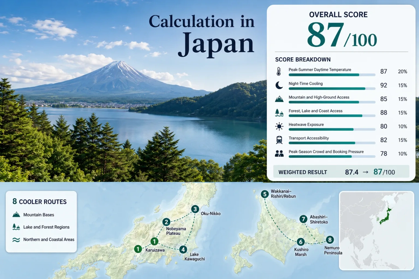
Japan away from summer heat shows mountain towns, northern islands, and forest retreats perfect for cooler escapes.

Japan Away from Summer Heat: Mountain Towns, Northern Islands and Forest Retreats

Japan’s most convincing July–August heat alternatives are not spread evenly across the country. They concentrate in high Honshu basins, elevated lake districts, forested volcanic plateaus and the maritime edges of eastern and northern Hokkaido. The route set below separates genuinely cooler bases from places that merely offer shade, water views or short high-altitude excursions while the accommodation zone remains warm.

Routes Assessed
8

Four highland or lake bases in Honshu and four maritime routes across northern and eastern Hokkaido.

Route Median Daytime Maximum
22.4°C

Calculated from July–August JMA 1991–2020 normals for the eight route stations.

Route Median Night Minimum
15.4°C

The strongest common advantage is overnight relief, especially on the Nobeyama Plateau and the Pacific side of Hokkaido.

Lowest-Heat Route
Nemuro Peninsula

Its July–August normal daytime maximum averages about 19.8°C, though fog, wind and long rail connections shape the experience.

Most Direct Highland Base
Karuizawa

A roughly 940-metre base with direct Hokuriku Shinkansen access, forest roads and cooler nights without a ferry or seasonal mountain road.

Main Planning Pressure
Obon and Capacity Windows

Mid-August demand, island ferry capacity, Fuji shuttle rules and infrequent rural services matter as much as temperature.

From Honshu Highlands to Japan’s Northern Edge

The markers connect elevated resort towns, volcanic lake country, wetland gateways and far-northern coastal bases. They represent planning centers rather than exact trailheads, viewpoints, legal parking areas or ferry berths.

Markers show selected cooler-route regions and planning centers, not guaranteed legal parking, trailheads or exact viewpoints. Use each route card for Google Maps links and access notes before traveling.

Japan Mountain, Forest and Northern-Island Suitability Score

This is a transparent editorial suitability index based on disclosed climate, landscape, access and pressure factors. It is not an official climate classification or a weather forecast. The result describes the eight routes shown on the map rather than Japan as a whole.

87out of 100
Calculated from 7 disclosed factors
Target summer windowJuly–August
Climate baselineJMA 1991–2020 normals
Heatwave periodJMA 1991–2020 threshold-frequency normals
Routes assessed8 routes; no route-count bonus
MethodologyVersion 1.2
Last reviewedJuly 15, 2026
Factor coverage7/7
Comparability qualityB — Official data with a gateway-station mapping and threshold-frequency fallback
Peak-Summer Daytime Temperature25%
93/100
Method: Equal-weight route aggregation using the median of each station’s July–August average daily maximum; linear interpolation on the fixed temperature scale. Raw: 22.425°C unrounded route median, displayed as 22.4°C. Route values: Karuizawa 25.8°C; Nobeyama Plateau 24.2°C; Oku-Nikko 22.5°C; Lake Kawaguchi 27.7°C; Wakkanai–Rishiri/Rebun Gateway 21.2°C; Kushiro Marsh 20.6°C; Abashiri–Shiretoko Gateway 22.4°C; Nemuro Peninsula 19.8°C. Median: 22.425°C. Source mapping: Karuizawa — direct JMA station 47622, route base and station both near 1,000 m; Nobeyama Plateau — direct AMeDAS 0415 in the plateau settlement; Oku-Nikko — direct JMA station 47690 in the high Oku-Nikko zone; Lake Kawaguchi — direct JMA station 47640 at the lake-town base; Wakkanai–Rishiri/Rebun Gateway — JMA 47401, direct for Wakkanai and representative maritime gateway for the islands across the Soya waters; Kushiro Marsh — JMA 47418, representative coastal gateway roughly 10–20 km from central wetland sectors with little elevation difference; Abashiri–Shiretoko Gateway — JMA 47409, direct for Abashiri and representative for the onward Okhotsk coastal corridor, with Utoro about 70 km away; Nemuro Peninsula — direct JMA station 47420. Period: 1991–2020 climate normals; July and August values averaged equally for every route. Sources: JMA Karuizawa; JMA Nobeyama; JMA Oku-Nikko; JMA Lake Kawaguchi; JMA Wakkanai; JMA Kushiro; JMA Abashiri; JMA Nemuro.
Night-Time Cooling20%
100/100
Method: Equal-weight median of July–August average daily minimum temperatures. The fixed scoring band awards full points to a route median from 10°C through 16°C. Raw: 15.425°C unrounded route median, displayed as 15.4°C. Route values: Karuizawa 16.8°C; Nobeyama Plateau 15.3°C; Oku-Nikko 15.3°C; Lake Kawaguchi 18.3°C; Wakkanai–Rishiri/Rebun Gateway 16.1°C; Kushiro Marsh 14.7°C; Abashiri–Shiretoko Gateway 15.6°C; Nemuro Peninsula 13.5°C. Median: 15.425°C. Source mapping: The same direct and representative JMA station mapping used for daytime temperature applies. Lake Kawaguchi is the only route whose two-month average minimum sits above the full-score 10–16°C band; the route median remains inside it. Period: JMA 1991–2020 normals for July and August. Sources: Japan Meteorological Agency historical climate database, using station pages linked in the daytime factor.
Mountain and High-Ground Access15%
55/100
Method: Fixed categorical altitude-access rubric applied to each accommodation base, followed by an equal-weight median. Raw: Route-score median 55/100. Route scores: Karuizawa 100 — accommodation base near 940–1,000 m; Nobeyama Plateau 100 — settlement and station near 1,345 m; Oku-Nikko 100 — lake, wetland and lodging zones broadly around 1,200–1,500 m; Lake Kawaguchi 80 — base near 833 m with regular access toward Mount Fuji’s higher road corridor; Wakkanai–Rishiri/Rebun Gateway 30 — dramatic island relief exists but requires ferry and onward local transport rather than a reliable 60-minute high-ground transfer from Wakkanai; Kushiro Marsh 0 — low wetland and coastal base; Abashiri–Shiretoko Gateway 30 — higher Shiretoko terrain needs a substantial onward transfer; Nemuro Peninsula 0 — low maritime peninsula. Median: 55/100. Route rationale: The Honshu group earns its cooling advantage from accommodation elevation or immediate high-road access. The Hokkaido coastal group relies on latitude and maritime air instead, so northern coolness does not automatically create mountain-access points. Period: Access and transport conditions reviewed July 15, 2026. Sources: Koumi Line elevation information; Official Nikko access information; Fuji Subaru Line bus access; Heart Land Ferry island routes; Ministry of the Environment Shiretoko National Park.
Forest, Lake and Coast Access15%
100/100
Method: Fixed physical-access rubric measuring whether a large forest, major lake or river system, or sea coast can be reached within 30 minutes from the route base. Raw: Route-score median 100/100. Route scores: Karuizawa 75 — broad forest access; Nobeyama Plateau 75 — forest and highland access, with major water less immediate; Oku-Nikko 100 — Lake Chuzenji plus extensive forest and wetland; Lake Kawaguchi 100 — major lake plus forested foothills; Wakkanai–Rishiri/Rebun Gateway 75 — immediate coast; Kushiro Marsh 100 — wetland river system plus Pacific coast; Abashiri–Shiretoko Gateway 100 — Sea of Okhotsk coast plus Shiretoko forest access; Nemuro Peninsula 100 — Pacific and Nemuro Strait coasts plus wetland systems. Median: 100/100. Route rationale: The factor measures practical physical access rather than scenic reputation. Most routes combine at least two strong cooling environments, while Karuizawa, Nobeyama and Wakkanai rely more heavily on one dominant element. Period: Current public access pattern reviewed July 15, 2026. Sources: Nikko National Park; Fuji-Hakone-Izu National Park; Kushiro-Shitsugen National Park; Shiretoko National Park; Rishiri and Rebun ferry network.
Heatwave Exposure10%
100/100
Method: Official threshold-frequency fallback. JMA’s 1991–2020 monthly normal counts for days with daily maximum at or above 30°C were summed for July and August, then divided by 62 calendar days. No incomplete daily series or reanalysis estimate was used. Raw: 0.9% route median exposure to 30°C-or-higher days in the target window. Route values: Karuizawa 9.0%; Nobeyama Plateau 1.5%; Oku-Nikko 0.0%; Lake Kawaguchi 28.9%; Wakkanai–Rishiri/Rebun Gateway 0.0%; Kushiro Marsh 0.3%; Abashiri–Shiretoko Gateway 2.1%; Nemuro Peninsula 0.0%. Median: 0.9%. Source mapping: Direct JMA threshold normals were used for Karuizawa 47622, Nobeyama 0415, Oku-Nikko 47690, Lake Kawaguchi 47640, Wakkanai 47401 and Nemuro 47420. Kushiro 47418 represents the marsh gateway; Abashiri 47409 represents the Abashiri end of the Shiretoko corridor. The gateway mappings make the factor suitable for route comparison but not for predicting conditions at every trail or island settlement. Period: JMA 1991–2020 official threshold-frequency normals for July and August. Sources: JMA station-normal and temperature-threshold tables. The linked database is the official interface used for the eight station records.
Transport Accessibility10%
80/100
Method: Fixed public-transport rubric applied to the route base and its defining landscape, followed by an equal-weight median. Raw: Route-score median 80/100. Route scores: Karuizawa 100 — direct Shinkansen and local mobility; Nobeyama Plateau 100 — direct Koumi Line station, although rural frequency requires schedule discipline; Oku-Nikko 80 — rail to Nikko followed by a sub-two-hour bus transfer; Lake Kawaguchi 100 — direct rail and coach access without a private car; Wakkanai–Rishiri/Rebun Gateway 20 — long-distance arrival plus ferry and limited island mobility; Kushiro Marsh 80 — major gateway with bus, rail and seasonal sightseeing services to selected wetland points; Abashiri–Shiretoko Gateway 60 — rail or airport access followed by a two-to-four-hour onward corridor; Nemuro Peninsula 60 — JR Hanasaki Line access but long journey times and limited frequency. Median: 80/100. Route rationale: Japan’s rail network makes the Honshu highland routes unusually car-light, but the far-north and eastern edges require timetable-led planning. A route can be climatically strong and still lose points when ferries or sparse onward buses define the day. Period: Timetables and operator access pages reviewed July 15, 2026. Sources: JR East Karuizawa timetable; Koumi Line; Tobu Nikko buses; Fujikyu Railway; Heart Land Ferry 2026 timetable; JR Hokkaido timetable search; Shiretoko Airport Liner.
Peak-Season Crowd and Booking Pressure5%
40/100
Method: Fixed categorical capacity-pressure rubric using official ferry schedules, shuttle restrictions, park access controls, rail reservation systems and operator peak-service information where comparable lodging occupancy was unavailable. Raw: Route-score median 40/100. Route scores: Karuizawa 40 — strong weekend and Obon-era room and road pressure; Nobeyama Plateau 80 — weekend demand without broad capacity controls; Oku-Nikko 40 — bus, road and major-site pressure across the lake corridor; Lake Kawaguchi 20 — widespread summer demand plus Mount Fuji shuttle and private-vehicle restrictions; Wakkanai–Rishiri/Rebun Gateway 40 — finite ferry departures and island room capacity; Kushiro Marsh 60 — regular seasonal demand at principal viewpoints but multiple gateway options; Abashiri–Shiretoko Gateway 40 — long-distance buses, park access limits and concentrated Utoro demand; Nemuro Peninsula 80 — lower visitor pressure with no broad reservation regime. Median: 40/100. Route rationale: Pressure is concentrated rather than national. Lake Kawaguchi, Karuizawa, Oku-Nikko and the island corridor require early decisions, while Nemuro and Nobeyama generally retain more flexibility outside holiday weekends. Period: 2026 operating rules and current official booking systems reviewed July 15, 2026. Sources: Fuji Subaru Line 2026 shuttle information; Official Mount Fuji private-vehicle restriction information; Heart Land Ferry 2026 sailing schedule; JR Hokkaido reservation information; Tobu Nikko bus access. Publicly comparable route-level occupancy was not available for all eight routes, so the published categorical fallback was applied consistently.

Weighted total: 93×0.25 + 100×0.20 + 55×0.15 + 100×0.15 + 100×0.10 + 80×0.10 + 40×0.05 = 86.5 → 87/100

Method: Every route carries equal weight within each factor. Route count adds no bonus; the route median is normalized first, then the seven fixed weights are applied.

Read the Cooler Escape scoring methodology

Highland Bases, Misty Wetlands and Far-North Coasts

The strongest choices divide into two systems: elevated Honshu bases that remain connected to major cities, and low-elevation Hokkaido coasts that use latitude, fog and cold-water influence rather than altitude. The trade-offs are different enough that temperature alone should not decide the route.

1

Karuizawa

Base elevation near 940–1,000 m gives Karuizawa a real accommodation-level advantage rather than a short excursion benefit. JMA normals average 25.8°C for daytime maxima and 16.8°C for night minima across July and August.

Direct ShinkansenForest roadsCooler nights

The station is reached directly from Tokyo on the Hokuriku Shinkansen, making it the clearest car-light mountain-town option in the set. Old Karuizawa, Naka-Karuizawa and the forested western side create several lodging patterns without moving the base down into a hot lowland city.

Watch for: Mid-August room demand and road congestion can erase the convenience advantage unless rail, accommodation and local movement are booked as one plan.

Karuizawa, Nagano on Google Maps

2

Nobeyama Plateau

Nobeyama Station sits at roughly 1,345 m, and the Koumi Line reaches Japan’s highest conventional-rail point near 1,375 m. July–August normals average 24.2°C by day and 15.3°C at night, with the plateau base doing the cooling work before any hike begins.

The route suits travelers who value open agricultural highland, forest edges and night relief more than a dense resort center. Direct rail access exists, but the rural timetable is less forgiving than Karuizawa’s.

1,345 m stationKoumi LineLow urban heat
Main caution: A missed local train can reshape half a day, so accommodation, meal times and station transfers need to follow the published Koumi Line schedule.

Nobeyama Plateau, Nagano on Google Maps

3

Oku-Nikko

Lake Chuzenji, Senjogahara and the Yumoto Onsen corridor occupy a high volcanic basin broadly around 1,200–1,500 m. The JMA Oku-Nikko station records a July–August average maximum of 22.5°C and minimum of 15.3°C.

Why it stands out: The accommodation zone, lake, wetland and forest are all high. There is no need to sleep in lowland Nikko and commute upward every day.

Tobu rail and bus links make the route workable without a car, but Irohazaka road traffic can slow buses. Rain is a substantial trade-off: JMA normals total more than 600 mm across July and August, so cooler air can arrive with prolonged wet periods.

Lake ChuzenjiSenjogaharaHigh rainfall

Oku-Nikko, Tochigi on Google Maps

4

Lake Kawaguchi

The lake-town base is roughly 833 m above sea level, served by Fujikyu Railway and direct highway buses. Its two-month normal maximum of 27.7°C and minimum of 18.3°C make it the warmest route in the set, despite the lake and nearby high-road access.

Lake breezes, forest edges and Mount Fuji transport add flexibility, but they do not turn every afternoon into cool weather. The official 1991–2020 threshold-frequency normal indicates that 30°C-or-higher days remain materially more common here than at the northern or higher routes.

Access rule: Fuji Subaru Line buses and shuttle arrangements change with road status and the private-vehicle restriction period. The 2026 operator timetable lists ticket availability from July 1 through October 30.

Lake Kawaguchi, Yamanashi on Google Maps

5

Wakkanai–Rishiri/Rebun Gateway

Wakkanai’s July–August normals average 21.2°C by day and 16.1°C at night. The route then extends across the Soya waters to Rishiri and Rebun, where maritime exposure, wind and island topography matter more than accommodation elevation.

Far-north latitudeFerry-dependentIsland wind

Heart Land Ferry’s 2026 summer schedule provides three daily Wakkanai–Oshidomari sailings from June 1 through September 30, each taking about 100 minutes. Wakkanai–Kafuka crossings take roughly 115 minutes and also operate three times daily in that window.

Planning pressure: Cool air does not remove capacity risk. Ferry departures, island buses and the limited accommodation inventory should be reserved around the same itinerary rather than handled separately.

Wakkanai, Rishiri and Rebun on Google Maps

6

Kushiro Marsh

20.6°C average daytime maximum and 14.7°C average night minimum place Kushiro among the coolest low-elevation routes. The effect comes from the cold Pacific margin, sea fog and the wetland system rather than mountain height.

Kushiro city provides rail and air access, while buses, local trains and selected seasonal sightseeing services reach different parts of the marsh. No single stop covers the entire wetland, so the route works better when one or two observation zones are chosen in advance.

The air can be cool yet humid. Fog, damp boardwalks and low cloud require light waterproof layers even when mainland Japan is under a heat alert.

Kushiro-Shitsugen National Park on Google Maps

7

Abashiri–Shiretoko Gateway

Abashiri’s July–August station normals average 22.4°C for daytime maxima and 15.6°C for minima. The city is a practical rail and airport-linked gateway, but the defining forest-and-coast environment lies farther east toward Shari and Utoro.

Rail reaches Shiretoko-Shari; onward buses to Utoro typically occupy about two hours of the day’s timetable. The long corridor means that a base in Abashiri and a base in Utoro are not interchangeable: Abashiri improves transport choice, while Utoro reduces daily transfer time into Shiretoko.

Okhotsk coastForest corridorLong onward transfer
Watch for: Park-road access, bus frequency and wildlife-management controls can change the usable day more than a small temperature difference.

Abashiri and Shiretoko, Hokkaido on Google Maps

8

Nemuro Peninsula

Nemuro is the lowest-heat route by the selected station metric: July–August normals average 19.8°C by day and 13.5°C at night. The peninsula remains low, exposed and maritime, with Pacific fog and wind replacing the altitude advantage of Honshu.

Hanasaki LineLow crowd pressureCoastal wind

JR’s Hanasaki Line links Kushiro and Nemuro in roughly two and a half hours on typical through services, but frequency is limited. A car expands access to Cape Nosappu, coastal wetlands and scattered viewpoints; without one, the trip should be built around current bus and rail departures.

Good for: Travelers prioritizing the lowest daytime heat and quiet coastal landscapes over fast connections, resort services or guaranteed clear skies.

Nemuro Peninsula, Hokkaido on Google Maps

Eight Routes, Four Different Ways to Reduce Heat

The route names stay identical to the map and score set. Temperature shows the broad climate advantage; elevation, transport and the main trade-off determine whether that advantage works for a specific trip.

RouteJuly–August Normal Max / MinCooling MechanismCar-Light AccessMain Trade-Off
Karuizawa25.8°C / 16.8°CHigh accommodation base and forest coverStrong: direct ShinkansenObon-era rooms and road congestion
Nobeyama Plateau24.2°C / 15.3°C1,345 m plateau baseGood: direct rural railInfrequent Koumi Line services
Oku-Nikko22.5°C / 15.3°CHigh volcanic basin, lake and forestGood: rail plus busHeavy summer rain and Irohazaka delays
Lake Kawaguchi27.7°C / 18.3°C833 m lake base plus high-road accessStrong: rail and direct coachesWarm afternoons and Fuji capacity controls
Wakkanai–Rishiri/Rebun Gateway21.2°C / 16.1°CFar-north latitude and maritime windLimited: long rail or air plus ferryFinite sailings and island room supply
Kushiro Marsh20.6°C / 14.7°CCold Pacific margin, fog and wetlandModerate: gateway rail, bus and seasonal servicesDamp air and dispersed observation points
Abashiri–Shiretoko Gateway22.4°C / 15.6°COkhotsk coast plus forested peninsulaModerate: rail or air plus long bus corridorAbashiri–Utoro transfer time
Nemuro Peninsula19.8°C / 13.5°CExposed maritime peninsulaLimited: long Hanasaki Line journeyFog, wind and sparse onward services

Obon, Island Ferries and Fuji Shuttle Windows

Japan’s cooler routes often fail at the logistics stage rather than the climate stage. Three different capacity systems shape July and August, and each requires a different response.

Mid-August Rail and Room Pressure

Karuizawa, Lake Kawaguchi and Oku-Nikko remain easy to reach on paper, but the Obon travel period concentrates intercity rail demand, accommodation bookings and road traffic. Car-light access does not mean last-minute access. Reserve the long-distance leg and the sleeping base before building day trips.

Rishiri and Rebun Sailing Geometry

The 2026 Heart Land Ferry schedule lists three daily Wakkanai departures to both Oshidomari and Kafuka from June 1 through September 30. That creates flexibility, but a missed sailing is measured in hours, not minutes. Weather disruption also affects the entire island sequence.

Fuji Road Controls

The Fuji Subaru Line’s high-altitude access depends on road status, shuttle operation and the private-vehicle restriction rules. The 2026 bus page lists sales from July 1 through October 30 and warns that services may stop or turn back when the road closes below the fifth station.

Pacific Fog, Mountain Rain and Why Cooler Is Not Always Drier

Kushiro and Nemuro

Cold Pacific influence suppresses daytime heat, but it also supports fog, low cloud and high relative humidity. Light rain shells, quick-drying layers and a plan that tolerates reduced visibility are more useful than treating these routes as crisp alpine climates.

Oku-Nikko Summer Rain

JMA normals total about 613 mm of precipitation across July and August. The route’s strong temperature score therefore comes with a real wet-weather trade-off. Lake and wetland walks need flexible timing, footwear with grip and indoor alternatives around prolonged rain.

Karuizawa and Nobeyama

High elevation improves nights but does not remove afternoon convection. Forest roads, exposed plateau sections and rail walks can shift quickly from sun to downpour. Morning outdoor blocks and a dry layer stored separately create a more reliable daily rhythm.

Shinkansen Bases or Remote Maritime Edges

The central decision is not simply mountains versus islands. It is whether the itinerary should preserve Japan’s high-frequency transport advantage or trade it for lower temperatures and thinner visitor pressure.

For a Car-Light Highland Trip

Karuizawa offers the cleanest Tokyo-to-cooler-base transition. Nobeyama Plateau provides greater elevation with a thinner timetable. Oku-Nikko adds lake and wetland access through rail-plus-bus connections. Lake Kawaguchi is the easiest Fuji-area base but also the warmest and most capacity-sensitive of the four.

For the Lowest Daytime Heat

Nemuro Peninsula and Kushiro Marsh have the lowest route-level daytime normals. Wakkanai–Rishiri/Rebun Gateway adds island wind and far-north light, while Abashiri–Shiretoko Gateway offers the strongest forest-and-coast combination. Each gives up frequency, simplicity or weather certainty in exchange.

Before departure: Check the current JMA forecast and heat information, then confirm JR, bus, ferry and park-road operation for the exact travel day. A cool long-term normal does not prevent a short hot spell, typhoon disruption, dense fog or a cancelled maritime connection.
📌

Complete guide: Asia