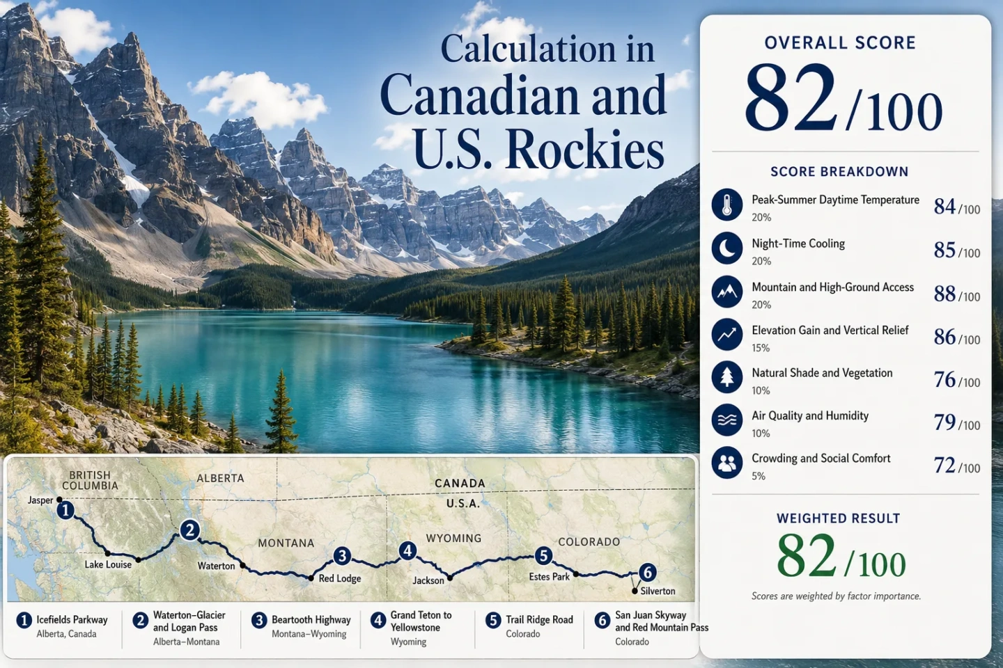
Cooler Summer Routes Through the Canadian and U.S. Rockies
Peak-summer relief in the Rockies does not come from latitude alone. It comes from how long a route stays high, whether the overnight base cools after sunset, and how quickly a road can climb from a warm valley to alpine terrain. Six corridors from Jasper to Colorado show three different patterns: sustained high-elevation travel, sharp vertical cooling on mountain passes, and cold-night basins that recover even after warm afternoons.
Two Canadian or cross-border corridors and four U.S. high-road systems, ordered from Alberta to the San Juan Mountains.
Trail Ridge Road reaches 12,183 ft, with 11 miles of roadway above treeline.
The Icefields Parkway links Lake Louise and Jasper without dropping back to a hot lowland city between the two park bases.
Red Lodge to the high Beartooth Highway rises from about 1,721 m to nearly 3,337 m.
At roughly 2,830 m, July and August normal minimum temperatures sit around 3–5°C, so warm afternoons lose heat quickly after sunset.
Logan Pass parking limits, Rocky Mountain timed entry, Grand Teton construction and Red Mountain Pass work can shape the day as much as temperature.
From Jasper to the San Juans: Six Summer Cooling Corridors
The route set follows the mountain chain rather than one continuous road trip. Some corridors are cool at the lodging base; others deliver most of their temperature relief only after a major climb.
Markers show selected cooling-route regions and planning centers, not guaranteed legal parking, trailheads or exact viewpoints. Route cards contain the location links and access details needed before traveling.
Where the Rockies Actually Stay Cooler
A cool summit road and a cool overnight base are different travel products. Icefields and Silverton begin high enough to retain a stronger night-cooling advantage; Beartooth and Trail Ridge create their largest temperature change during the climb itself.
Jasper → Icefields Parkway → Lake Louise
Jasper already functions as a cool overnight base. Its 1991–2020 climate normal puts the average daily maximum at 23.4°C in July and 23.0°C in August, while average minima fall to 7.4°C and 6.1°C. The road then stays within a high mountain system instead of descending to prairie or interior-basin heat.
Bow Summit is the highest point on the parkway at 2,070 m. That roughly 1,000 m rise from Jasper is enough for a clear temperature step on many days, especially with cloud or wind over exposed terrain. The route therefore combines a relatively cool sleeping base with sustained daytime high-ground access.
Waterton → Chief Mountain → Glacier → Logan Pass
The Waterton side begins near 1,280 m, while Logan Pass reaches 2,025 m on Going-to-the-Sun Road. An older Waterton-area normal at 1,281 m shows July–August daily maxima near 22°C and minima near 7°C, which is useful as a local cooling signal even though it should not be treated as a cross-border climate baseline.
Cooling strengthens with the climb toward the Continental Divide. The lower west side around the Flathead Valley can be much warmer, so a Whitefish or low-valley lodging temperature should not be substituted for the conditions at Logan Pass.
Red Lodge → Beartooth Highway → Cooke City
Beartooth is a vertical heat-escape route rather than a cool-town route. Red Lodge normals put July and August afternoon highs around 27–28°C, with nights near 10°C. U.S. 212 then climbs to 10,947 ft, crossing treeless plateau terrain where air temperature, wind and exposure can feel completely different from the start of the drive.
The elevation change alone corresponds to roughly 10–11°C of cooling under a standard lapse-rate estimate. Actual conditions can depart sharply from that estimate because fronts, cloud, wind and sun exposure change quickly on the plateau.
Jackson–Moose → Grand Teton → Yellowstone
The strongest thermal advantage here is not a dramatic summit climb. It is the daily temperature range of the high basin. The Moose climate station sits near 1,964 m; July–August normal afternoons are around 27°C, while average minimum temperatures fall to roughly 5–7°C. A warm hiking afternoon can therefore be followed by a very cool sleeping window.
Jenny Lake, Jackson Lake and forested stops provide lower-exertion alternatives during the warmest part of the day. Continuing north toward Yellowstone keeps the route on a high plateau rather than dropping into a hot lowland transfer.
Estes Park → Trail Ridge Road → Grand Lake
Trail Ridge Road creates one of the clearest vertical temperature transitions available by paved road in the Rockies. Estes Park sits around 2,381 m at the representative station, with July–August normal afternoon highs roughly 26°C and average minima around 8–9°C. U.S. 34 then rises another 1,300 m to its 12,183 ft high point.
The treeline crossing matters as much as the number on a thermometer. Shade decreases, wind strengthens and UV exposure rises while air temperature falls. Cooler air can coexist with stronger solar exposure.
Ouray → Red Mountain Pass → Silverton and the San Juan Skyway
Silverton changes the equation because the lodging base is already near 2,830 m. July and August normal afternoon highs are roughly 24°C and 23°C, while average minima are around 5°C and 3°C. The overnight base therefore carries more of the cooling load than it does on routes that start hundreds of metres lower.
Red Mountain Pass adds another 528 m, but the larger planning issue is weather reliability. Summer afternoon thundershowers are part of the San Juan pattern, and steep canyon roads can be affected by rock, mud or water well away from the cloudburst that triggers them.
A High Pass and a Cool Overnight Base Are Not the Same Thing
A rough environmental lapse-rate reference is about 6–7°C of cooling per 1,000 m of elevation gain. It is useful for comparing route geometry, but it is not a forecast. Cloud, wind, humidity, slope exposure, inversions and air masses can erase or enlarge the theoretical difference.
| Corridor | Representative Base | High-Road Point | Vertical Change | Elevation-Only Cooling Reference | What Actually Provides Relief |
|---|---|---|---|---|---|
| Icefields Parkway | Jasper ~1,062 m | Bow Summit 2,070 m | ~+1,008 m | ~6–7°C | Cool base plus a road that remains high for long stretches |
| Waterton–Glacier and Logan Pass | Waterton zone ~1,280 m | Logan Pass 2,025 m | ~+745 m | ~4–5°C | Wind and elevation at the pass; lower west-side lodging can be warmer |
| Beartooth Highway | Red Lodge 1,721 m | High point 3,337 m | ~+1,616 m | ~10–11°C | The climb itself; Red Lodge can still have warm afternoons |
| Grand Teton to Yellowstone | Moose ~1,964 m | Yellowstone plateau sectors ~2,300–2,500 m | ~+350–550 m | ~2–4°C | Strong night cooling and a consistently high basin/plateau |
| Trail Ridge Road | Estes Park ~2,381 m | High point 3,713 m | ~+1,332 m | ~8–9°C | A rapid climb from montane forest to exposed alpine tundra |
| San Juan Skyway and Red Mountain Pass | Silverton 2,830 m | Red Mountain Pass 3,358 m | ~+528 m | ~3–4°C | An already-high sleeping base plus several high passes |
Logan Pass, Trail Ridge and Red Mountain Can Be Limited by Access Before Heat
Logan Pass: Three Hours by Car, Longer by Shuttle
Private-vehicle parking is limited to three hours from July 1 through September 7, 2026, and a space is not guaranteed. Glacier removed the park-wide vehicle-reservation requirement for 2026, but long Logan Pass days now favor the ticketed shuttle rather than leaving a private car at the pass.
Trail Ridge: Time the Gate as Well as the Temperature
General timed entry runs from 9 a.m. to 2 p.m. through October 12, 2026. An early start serves two purposes: it avoids the timed-entry window for Trail Ridge Road and puts the exposed alpine section earlier in the day, before the strongest afternoon heating and thunderstorm cycle.
Grand Teton: Construction Changes Transfer Time
North Park Road work can add about 15 minutes by day and up to an hour at night. Moose–Wilson Road can add 45 minutes or more. Those delays matter on a cooling-focused itinerary because they can move a lake walk or high-ground drive into the warmer part of the afternoon.
Red Mountain: Road Reliability Is Part of the Climate Decision
Alternating traffic and up to 20-minute delays continue during the 2026 US 550 repair project. July flooding also forced a two-day closure after mud and debris crossed the highway. A cool high pass has little value to a route plan when a storm closes the only direct mountain connection.
Waterton–Glacier Has a Border Clock the Other Corridors Do Not
The Chief Mountain port of entry is the direct seasonal mountain crossing between Waterton Lakes and Glacier. For 2026 it operates from May 15 through September 30. Hours are 7 a.m.–10 p.m. from June 1 through September 7, then 9 a.m.–6 p.m. from September 8 through September 30. Outside that season, the direct Waterton-to-Glacier line disappears and a longer year-round crossing must replace it.
The border schedule can determine whether Logan Pass belongs on the same day as Waterton. Rental-car agreements also need to permit cross-border travel; one-way international vehicle drop-off is a separate issue and should not be assumed. The temperature map does not show either constraint.
| Summer Window | Route Logic | Main Constraint |
|---|---|---|
| Late June | Icefields, Grand Teton and Trail Ridge can deliver very cool high-ground days while snow may still linger on alpine trails. | High-road openings and trail conditions remain more fragile than in mid-summer. |
| July to mid-August | All six corridors are normally in their broad road-access window, making vertical cooling easiest to use. | Parking, timed entry, shuttle capacity, construction and smoke become the larger planning variables. |
| Late August to early September | Night cooling strengthens while high roads usually remain usable. | Shorter daylight, wildfire smoke and the first early-season snow events gain importance. |
| September 8–30 | Waterton–Glacier remains cross-border capable through Chief Mountain. | The crossing shortens to 9 a.m.–6 p.m.; Beartooth and Trail Ridge also become more sensitive to early winter weather. |
Northern Smoke and San Juan Storms Can Reverse a Cooler-Day Plan
Elevation reduces air temperature, not every form of summer exposure. Smoke can fill a high basin or cross a pass, and a Colorado thunderstorm can make the highest road the least useful place to be even when the air is cool.
Jasper, Glacier and Yellowstone Can Share Smoke Without Sharing the Same Fire
Regional smoke can travel far from an active fire. Valley inversions may trap it low in the morning, but a high pass is not a guaranteed escape when the entire air mass is affected. On smoky days, low-exertion lake and forest stops are often more sensible than a strenuous exposed hike.
The San Juans Shift the Main Risk Toward Afternoon Thunderstorms
Red Mountain Pass and the San Juan Skyway sit in terrain where summer thundershowers, lightning and intense localized rain can disrupt a high-road day. The July 2026 Red Mountain closure showed how quickly rain can turn into a road-access problem through mud and debris.
Beartooth and Trail Ridge Trade Heat for Wind, UV and Thin Air
Road temperatures can fall sharply above treeline while solar exposure increases and oxygen pressure decreases. Layering, sun protection, hydration and a slower walking pace remain relevant even when the dashboard temperature looks mild.