Mexico Beyond the Beach Heat: Highland Cities, Pine Forests and Mountain Villages
Mexico’s coastal heat is only one part of the country’s summer climate. This route set follows elevated city bases, conifer forests and mountain communities from Ajusco to Mexiquillo. July–August route-base averages range from 14.8°C to 30.5°C by day, while the route median falls to 12.1°C at night. Altitude matters, but the strongest relief often appears only after leaving a warmer plateau city for a higher forest road, cabin zone or community-managed mountain village.
The score, marker map, destination portfolio and comparison matrix use the same eight route systems.
July–August station averages show why “highland Mexico” cannot be treated as one temperature band.
Cool nights are the most consistent advantage across the selected routes, even where afternoons remain warm.
Every climate station sits in a highland base; several forest endpoints rise well above the station level.
Cloud and rain suppress heat, but they also add fog, slippery trails and slower mountain-road travel.
The direct high-mountain station produces the lowest daytime value in the portfolio, paired with cold nights and community forest access.
From Ajusco to Mexiquillo: Mexico’s Highland Cooling Corridors
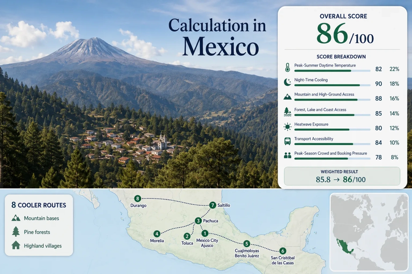
The markers connect city bases with the mountain or forest destination that gives each route its cooling logic. Several climate stations sit at the urban base rather than the highest endpoint, so route cards identify where the measured city climate ends and the cooler forest zone begins.
Markers show planning centers for the selected highland corridors. They do not identify exact trailheads, legal parking areas, cabin entrances or road conditions. Use the named Google Maps links and current local access information before traveling.
Mexico Highland Cooler Escape Suitability Score
This transparent editorial suitability index uses disclosed climate, landscape, access and pressure factors. It is not an official climate classification or a weather forecast. Route count adds no bonus; each factor is calculated from the median of the same eight routes.
Weighted total: 78×0.25 + 100×0.20 + 100×0.15 + 75×0.15 + 100×0.10 + 70×0.10 + 60×0.05 = 85.8 → 86/100
Method: Route count does not add bonus points. Route-level values are combined by median before the fixed weights are applied. City-base station proxies make the warmest northern corridors look less favorable than their higher forest endpoints, which is preferable to overstating coolness.
Highland Cities, Pine Forests and Mountain Villages Across Mexico
Each corridor pairs an overnight base with the higher landscape that changes the summer experience. The measured station climate belongs to the named base or direct mountain station; forest roads and villages can be cooler than the listed value where the elevation rises.
Mexico City and Ajusco
Mexico City provides the strongest urban-services base in the set, while Ajusco and the southern protected forests supply the altitude step. The city station sits at 2,303 m and records July–August averages of 24.7°C by day and 13.0°C at night. The climate is comfortable after sunset, but paved districts can still hold afternoon heat.
Rain is frequent: the station record converts to about 31.7 wet days per 61-day window. Forest outings therefore work better with an early start and a flexible return before afternoon storms build.
Toluca and Nevado de Toluca
2,726 m station elevation, 21.5°C average daytime maximum and 7.8°C average minimum: Toluca already behaves like a cool high plateau before the road climbs toward the volcano. CONANP lists Nevado de Toluca at 4,680 m, creating the largest vertical range in the route set.
The same July–August record produces roughly 34.2 wet days, the highest rain-day estimate in the portfolio. Cloud can lower the temperature quickly, but it can also erase crater views and make exposed high ground unsuitable.
Pachuca and Mineral del Chico
Pachuca’s representative station is only about 16 km from Mineral del Chico and occupies a similar highland band. Its July–August values are 22.7°C by day, 11.0°C at night and 2,435 m elevation, making this the cleanest city-to-forest comparison in the central route group.
About 14.0 wet days per 61-day window is much lower than Toluca, Mexico City or Morelia. That does not remove storm risk, but it improves the chance of combining a town stay with forest walking without losing most afternoons to rain.
Morelia and Angangueo
Morelia is the warmest central-city base in the selection, averaging 27.1°C by day and 13.4°C at night at a 1,913 m station. The cooling gain appears later, on the eastbound road into Angangueo and the oyamel forest belt.
The representative station produces about 29.9 wet days. Morelia works as a service-rich first night, but sleeping in Angangueo better matches the title’s mountain-village intent. The station is roughly 95 km away and 600–700 m lower, so its daytime figure is conservative for the endpoint.
Cuajimoloyas and Benito Juárez
The direct Cuajimoloyas station sits at 2,853 m. Its July–August averages are 14.8°C by day and 6.1°C at night, the lowest daytime and near-lowest night values in the portfolio. A light jacket is not merely an evening precaution here; poorly heated cabins can feel cold after rain.
About 29.8 wet days places the route firmly inside the Sierra Norte wet-season rhythm. Cloud and forest shade suppress heat, while fog, muddy paths and slower transfers limit rigid day-by-day scheduling.
San Cristóbal de las Casas
San Cristóbal is the most practical southern highland city in the set. The direct station, about 2 km from the center, stands at 2,116 m and averages 24.5°C by day and 11.2°C at night in July–August.
Its rain-day estimate is 22.4 days per 61-day window. The official tourism platform notes regular bus access from Tuxtla Gutiérrez, making it the clearest option for travelers who want cool nights without arranging a private mountain transfer.
Saltillo and Arteaga
Saltillo’s 1,790 m station still averages 29.4°C by day, and 43.2% of valid days in its selected heat-threshold window reached 30°C or more. The night average drops to 16.2°C, so the route’s value comes from evening recovery and the short move into Arteaga’s pine country rather than a cool city afternoon.
Visit Mexico places Arteaga about 14 km from Saltillo. The station record is relatively dry for the portfolio, at about 14.6 wet days, which supports road access but increases the need to check fire and smoke conditions during dry or windy spells.
Durango and Mexiquillo
Warm base, cool endpoint: Durango’s station averages 30.5°C by day and 14.0°C at night at 1,872 m. Its selected heat-threshold window records 30°C or more on 70.6% of valid July–August days. The city is therefore a staging point, not the final heat refuge.
Mexiquillo lies deep in the Sierra Madre Occidental, with extensive forest and waterfall features. The Durango station is roughly 150 km away and substantially lower, while the route records about 23.9 wet days at the city base.
Why Cuajimoloyas Changes the Temperature Scale
Cuajimoloyas is not merely the highest station in the route set. Its 14.8°C July–August daytime average sits 6.7°C below Toluca, the next-coolest measured base, and 15.6°C below Durango. The 6.1°C night average also changes packing and accommodation decisions: an unheated cabin can be uncomfortable even when the trip was planned as a summer escape.
The lower temperature comes with a clear cost. Roughly 30 wet days fall inside the 61-day target window, road transfers are less frequent, and community-managed access rewards advance coordination. Cuajimoloyas suits a traveler willing to trade urban convenience for the strongest measured cool-air result.
Saltillo and Durango Need the Forest Endpoint
Northern elevation alone does not neutralize peak-summer sun. Saltillo and Durango stand well above sea level, yet their route-base station averages remain 29.4°C and 30.5°C by day.
Saltillo to Arteaga
The transfer is short, about 14 km, but it changes land cover from a built plateau city to pine-forested mountain surroundings. The city retains a useful 16.2°C night average; the forest adds shade and less urban heat storage.
Durango to Mexiquillo
The climate gain requires a much longer road stage. Durango is a practical transport and supply base, while Mexiquillo supplies the forest, water features and higher Sierra Madre setting. Stopping in the city leaves the hottest daytime value in the portfolio unchanged.
July–August Rain Reorders the Central Highlands
Rain helps suppress heat, but the same mechanism limits views, trails and road speed. The station records produce three distinct planning groups.
Toluca, Mexico City, Morelia and Cuajimoloyas
Each route approaches 30 or more wet days during the 61-day window. Morning activity, a covered afternoon option and a buffer day are more useful than a tightly fixed scenic schedule.
San Cristóbal and Durango
About 22–24 wet days create a mixed pattern. Several usable mornings can be followed by heavy cloud or storms, especially where the route climbs into forest.
Pachuca and Saltillo
Roughly 14–15 wet days improve road reliability. The trade-off is stronger sun exposure and, around Arteaga, a greater need to check dry-season fire or smoke conditions.
Protected Areas, Community Forests and Seasonal Rules
Nevado de Toluca and El Chico
Protected-area schedules, fees, weather closures and vehicle controls can change the usable route. A city hotel reservation does not guarantee access to the high road or trail zone.
Sierra Norte Communities
Cuajimoloyas and Benito Juárez operate within community tourism systems. Local lodging, community accompaniment and trail arrangements should be confirmed directly, and community land should not be treated as unrestricted public terrain.
Angangueo Outside Butterfly Season
July–August offers a mountain-town and forest stay, not the winter monarch spectacle. The distinction reduces summer crowd pressure but also changes which sanctuary services may be operating.
Eight Routes Compared by Night Cooling, Rain and Access
Climate figures use the disclosed representative or direct station. “Car-light” describes whether the full city-to-forest route can be completed without relying heavily on a private vehicle.
| Route | July–August Day / Night | Station Elevation | Wet Days per 61 | Car-Light Practicality | Main Trade-Off |
|---|---|---|---|---|---|
| Mexico City and Ajusco | 24.7°C / 13.0°C | 2,303 m | 31.7 | Moderate | Easy urban base; frequent rain and a separate forest transfer |
| Toluca and Nevado de Toluca | 21.5°C / 7.8°C | 2,726 m | 34.2 | Limited | Very cool base; managed high-mountain access and cloud |
| Pachuca and Mineral del Chico | 22.7°C / 11.0°C | 2,435 m | 14.0 | Moderate–strong | Short forest transfer; weekend pressure |
| Morelia and Angangueo | 27.1°C / 13.4°C | 1,913 m | 29.9 | Moderate | Warm city base; cooling arrives near the mountain endpoint |
| Cuajimoloyas and Benito Juárez | 14.8°C / 6.1°C | 2,853 m | 29.8 | Low | Lowest heat; cold cabins, rain and coordinated transfers |
| San Cristóbal de las Casas | 24.5°C / 11.2°C | 2,116 m | 22.4 | Strong | Easy city stay; damp rooms and summer booking pressure |
| Saltillo and Arteaga | 29.4°C / 16.2°C | 1,790 m | 14.6 | Moderate–strong | Warm afternoons; short move into pine country |
| Durango and Mexiquillo | 30.5°C / 14.0°C | 1,872 m | 23.9 | Low | Long road transfer; city climate does not represent the forest endpoint |