Sri Lanka Highland Escapes: Tea Country, Misty Towns and Mountain Rail
Sri Lanka’s Main Line climbs from tropical lowlands into a compact belt of tea estates, cloud forest and high railway towns. The clearest cooler-weather corridor runs from Nanu Oya through Ambewela, Pattipola and Ohiya before descending toward Haputale and Ella, where elevation still softens the heat but afternoon temperatures and visitor pressure rise.
Six sit directly on the Main Line; Nuwara Eliya uses Nanu Oya as its rail gateway.
Railway settlements around 1,800–1,900 metres carry the strongest daytime and night-cooling advantage.
The upper corridor stays cool, though southwest-monsoon mist and frequent rain affect views and walking plans.
The railway handles long transfers; road connections remain necessary for Nuwara Eliya and Horton Plains.
The route set’s median July–August daytime proxy is about 19.4°C across the upper highlands.
Badulla–Nanu Oya services resumed on June 18, 2026 after repair of the Ambewela–Nanu Oya section.
The Nanu Oya–Ella Rail Spine Across Sri Lanka’s Tea Highlands
The markers follow a west-to-east highland sequence rather than a general island map. They show practical town or station centres for planning, with the highest and coolest rail band concentrated between Nanu Oya and Ohiya.
This marker map is built for planning orientation. Marker positions use approximate public location centres where exact viewpoints, trailheads, legal parking areas or pull-offs are not specified. Use each route card for Google Maps links and access notes before traveling.
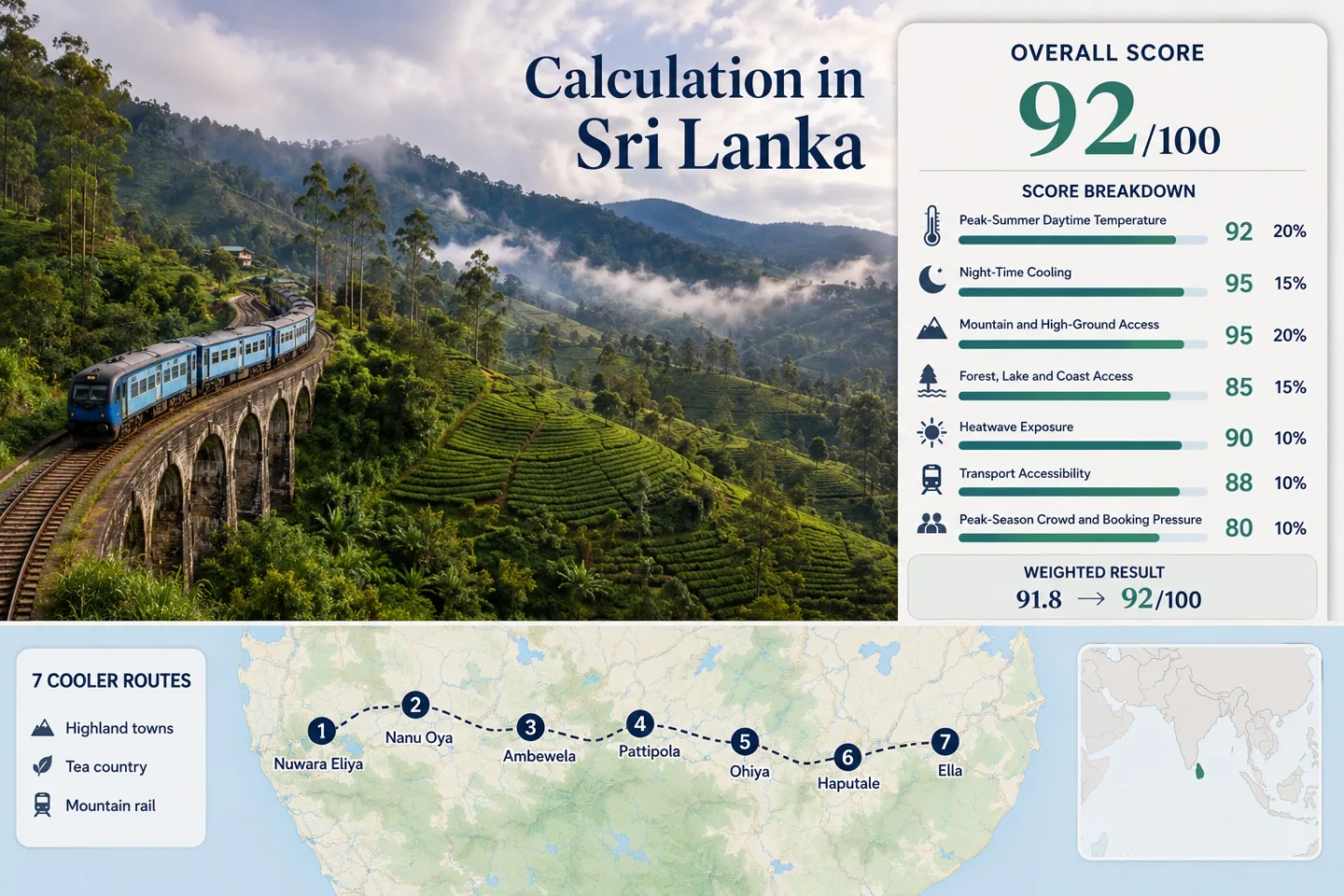
Sri Lanka Tea-Highland Cooler Escape Suitability Score
This transparent editorial suitability index uses the seven mapped bases, not a national temperature average. It combines disclosed climate, landscape, access and pressure factors. It is not an official climate classification or a weather forecast.
Very strong highland suitability, driven by low upper-corridor daytime temperatures, cool nights, direct access to high ground and a rare chain of rail-served mountain bases.
Method: Route-median July–August mean daily maximum, normalized with 21°C or lower equal to 100. Nuwara Eliya uses the WMO station normal directly. Nanu Oya, Ambewela, Pattipola and Ohiya use altitude-adjusted representative values from the same upper-highland anchor. Haputale and Ella use an elevation-adjusted Badulla climate proxy.
Raw: 19.4°C route median.
Route values: Nuwara Eliya 18.6°C; Nanu Oya 20.5°C; Ambewela 19.0°C; Pattipola 18.6°C; Ohiya 19.4°C; Haputale 23.7°C; Ella 26.3°C.
Source mapping: Nuwara Eliya is the direct official climate anchor. Upper-corridor adjustments reflect approximate public elevations, proximity within the same massif and the official national climate description of roughly 6.5°C cooling per 1,000 metres of elevation. Haputale and Ella are not represented by the Nuwara Eliya station; their figures use a disclosed Badulla-based gridded and elevation proxy and therefore carry lower comparability.
Period: WMO Nuwara Eliya climatology 1961–1990; southern route proxy reviewed July 2026.
Sources: WMO World Weather Information Service — Nuwara Eliya; Badulla MERRA-2-based climate summary; NASA POWER temporal-data documentation.
Method: Route-median July–August mean daily minimum. The 10–16°C comfort band scores 100. The same direct-anchor and representative-proxy structure used for daytime temperature is applied consistently.
Raw: 13.5°C route median.
Route values: Nuwara Eliya 12.8°C; Nanu Oya 14.6°C; Ambewela 13.2°C; Pattipola 12.7°C; Ohiya 13.5°C; Haputale 14.5°C; Ella 17.1°C.
Route interpretation: The upper five bases sit inside or close to the ideal night-cooling band. Ella is the warmest overnight base in the portfolio and falls outside the full-score band at route level, but it does not move the seven-route median.
Period: Night-time values use the WMO Nuwara Eliya 1961–1990 climatology; the Haputale–Ella proxy was reviewed in July 2026.
Sources: WMO Nuwara Eliya climate normals; WeatherSpark — Badulla climate history; NASA POWER temporal API documentation.
Method: Fixed elevation rubric. A lodging or town base at 900 metres or higher scores 100. All seven route centres exceed that threshold.
Raw: 100-point route median.
Route scores: Nuwara Eliya 100 — about 1,868 m; Nanu Oya 100 — about 1,610 m; Ambewela 100 — about 1,828 m; Pattipola 100 — about 1,898 m; Ohiya 100 — about 1,774 m; Haputale 100 — about 1,431 m; Ella 100 — about 1,041 m.
Rationale: The route does not depend on a distant day trip to reach elevation; the accommodation and station bases themselves are already high.
Period: Current geographic and access conditions reviewed July 2026.
Sources: Sri Lanka Railways station sequence and Main Line distances; Sri Lanka Department of Census and Statistics — area and climate.
Method: Fixed physical-access rubric. A route scores 100 with two strong forest, large-water or coast elements within 30 minutes; 75 with one strong element within 30 minutes.
Raw: 75-point route median.
Route scores: Nuwara Eliya 100 — Gregory Lake and montane-forest access; Nanu Oya 75 — forested tea slopes; Ambewela 75 — upper grassland and forest edge; Pattipola 75 — montane forest and Horton Plains approach; Ohiya 75 — cloud-forest access; Haputale 75 — forested escarpment and tea country; Ella 75 — forested valleys and major waterfall corridors.
Rationale: This factor measures actual physical access, not scenic reputation. The route is strong for forest and upland water, but it has no coast access and only Nuwara Eliya clearly combines two qualifying elements close to the base.
Period: Current access pattern reviewed July 2026.
Sources: Sri Lanka Department of Wildlife Conservation; Sri Lanka Department of Census and Statistics — geography and climate.
Method: Proxy-dataset screening estimate for the share of July–August days reaching 30°C or more. This is not presented as an exact daily station count because a uniform, route-level ten-summer series could not be verified for all seven bases.
Raw: 0% route median; the 0–1% normalization band scores 100.
Route values: Nuwara Eliya 0%; Nanu Oya 0%; Ambewela 0%; Pattipola 0%; Ohiya 0%; Haputale 1%; Ella 2%.
Coverage and caution: The upper five values are constrained by the high-elevation Nuwara Eliya station record and representative altitude adjustments. Haputale and Ella use a Badulla and MERRA-2 elevation screening proxy. No “0/N days” claim is made, and this factor is the main reason comparability is classified C rather than A or B.
Period: Published Nuwara Eliya station context; proxy screening reviewed July 2026.
Sources: WMO World Weather Information Service — Nuwara Eliya; NASA POWER point and daily temporal-data documentation; Badulla MERRA-2-based climate summary.
Method: Fixed transport rubric based on direct rail or regular bus access, transfer complexity and local mobility after arrival.
Raw: 80-point route median.
Route scores: Nuwara Eliya 80 — rail to Nanu Oya plus road transfer; Nanu Oya 100 — direct Main Line station and road hub; Ambewela 80 — direct rail but limited local onward transport; Pattipola 80 — direct rail with road transfer needed for Horton Plains; Ohiya 80 — direct rail with limited local vehicles; Haputale 100 — direct rail and town services; Ella 100 — direct rail, buses and abundant local transfers.
Current status: Sri Lanka Railways reported that Badulla–Nanu Oya services resumed on June 18, 2026 after restoration of the Ambewela–Nanu Oya section. Live schedules still need checking because mountain-line operations can change after severe weather.
Period: Network status and station access reviewed July 21, 2026.
Sources: Sri Lanka Railways service notices; Sri Lanka Railways station details; Sri Lanka Railways seat reservation portal.
Method: Fixed crowd-pressure rubric using rail reservation friction, concentration of registered accommodation and attraction demand. Route-level lodging occupancy is not published consistently enough for a uniform numerical occupancy series.
Raw: 60-point route median.
Route scores: Nuwara Eliya 40 — concentrated accommodation and holiday demand; Nanu Oya 60 — transfer and reserved-seat pressure; Ambewela 80 — lower overnight concentration; Pattipola 80 — limited base capacity but lower town demand; Ohiya 80 — small-scale stays and weekend pressure; Haputale 60 — regular peak demand without Ella-level concentration; Ella 40 — strong accommodation, rail-seat and attraction pressure.
Rationale: July–August is not Sri Lanka’s single national tourism peak, yet Ella and Nuwara Eliya can still create local bottlenecks. Smaller rail stops reduce crowd volume but also have less room inventory and fewer fallback vehicles.
Period: Latest available tourism reporting and current reservation system reviewed July 2026.
Sources: Sri Lanka Tourism Development Authority — Year in Review 2024; Sri Lanka Railways seat reservation portal; Official ticket-printing locations.
Each route carries equal weight. The route count itself adds no points, and the rounded total is written to the page ranking attribute.
Tea Towns, High Stations and Escarpment Bases
The sequence matters. Nuwara Eliya and the upper railway villages deliver the clearest cooling, while Haputale and Ella trade a few degrees of relief for easier services, broader lodging choice and quicker access to lower valleys.
Nuwara Eliya: Lake Air and the Most Complete Highland Base
Cool-air character: The town sits close to the WMO climate station used as the upper-route anchor. July and August average maximums are around 19°C, with nights near 13°C and roughly 16–17 rain days per month in the older official normal.
Gregory Lake, Victoria Park and nearby montane forest make this the only base in the set with both substantial water and forest access close to town. The trade-off is frequent cloud, wet pavements and stronger holiday-period accommodation pressure.
Nanu Oya: The Rail Gateway With Cooler Nights
Nanu Oya works less as a resort town and more as the corridor’s transfer hinge. Sri Lanka Railways lists it before Ambewela on the Main Line, and road vehicles connect the station to Nuwara Eliya.
The lower elevation relative to Nuwara Eliya slightly raises the daytime proxy, but nights remain firmly within the score’s ideal cooling band. Staying near the station can simplify an early departure east, while town services and evening dining are more limited than in Nuwara Eliya.
Ambewela: Open Grassland, Dairy Country and Fast Weather Changes
Ambewela replaces dense town fabric with exposed upland grassland, dairy farms and tea-country edges. That openness increases wind exposure and can make a damp day feel colder than the temperature suggests.
The station is only about 14.4 rail kilometres beyond Nanu Oya, yet local transport is thinner. Accommodation choice is modest, and a vehicle arranged in advance is more useful for farm visits, trail approaches or a same-day connection to Pattipola.
Pattipola: The Highest Rail Stop and a Horton Plains Approach
Pattipola is the route’s strongest pure elevation choice. The railway reaches the high plateau directly, while nearby road connections lead toward Horton Plains National Park rather than into a large service town.
July–August mist can be persistent, and the small settlement offers fewer fallback restaurants, vehicles and rooms. The reward is a lodging and station band close to 1,900 metres, where both daytime heat and warm nights are uncommon relative to Sri Lanka’s lowlands.
Ohiya: Cloud Forest, Rail Isolation and an Eastern Park Approach
Ohiya sits on the forested side of the ridge and feels more isolated than its rail connection suggests. Cloud can close around the station quickly, and the road toward Horton Plains depends on pre-arranged local transport rather than a dense public network.
The station lies about 6.7 rail kilometres beyond Pattipola. That short distance crosses a meaningful landscape transition: forest cover thickens, visibility becomes less predictable and the village offers fewer services.
Haputale: Escarpment Air With a More Functional Town Base
Haputale is warmer than Pattipola or Ohiya but more practical for a multi-night stay. The town has direct rail access, local buses, food services and a dramatic position on the Uva escarpment, where cloud and wind can arrive from one side while lower valleys remain visible on the other.
Its daytime proxy sits about 4°C above the upper-route median, yet the nights still provide meaningful relief. Haputale suits travelers who want tea-estate access and town convenience without accepting Ella’s higher heat and visitor concentration.
Ella: Easier Services at the Warmer End of the Highland Line
Ella remains cooler than Sri Lanka’s hotter lowlands, but it is not climatically equivalent to Nuwara Eliya, Pattipola or Ohiya. The lower elevation raises afternoon and overnight temperatures, especially when cloud breaks east of the ridge.
Its advantage is logistical depth: direct rail, buses, numerous rooms, restaurants and abundant local vehicles. Those same strengths create the route portfolio’s highest booking and attraction pressure alongside Nuwara Eliya.
Seven Bases Compared by Heat, Rail Access and Local Friction
All seven mapped bases appear in the same decision matrix. Temperature figures are disclosed route proxies rather than a claim that every hotel or hillside shares one exact microclimate.
| Base | Approximate elevation | July–August day / night proxy | Rail relationship | Main local friction |
|---|---|---|---|---|
| Nuwara Eliya | 1,868 m | 18.6°C / 12.8°C | Road transfer from Nanu Oya | Wet weather, holiday lodging pressure and station transfer |
| Nanu Oya | 1,610 m | 20.5°C / 14.6°C | Direct Main Line station | Train-time taxi concentration and limited evening services |
| Ambewela | 1,828 m | 19.0°C / 13.2°C | Direct Main Line station | Thin local transport and exposed wet wind |
| Pattipola | 1,898 m | 18.6°C / 12.7°C | Direct Main Line station | Small room inventory and road transfer to Horton Plains |
| Ohiya | 1,774 m | 19.4°C / 13.5°C | Direct Main Line station | Few fallback vehicles after late arrivals |
| Haputale | 1,431 m | 23.7°C / 14.5°C | Direct Main Line station and buses | Warmer afternoons than the upper plateau |
| Ella | 1,041 m | 26.3°C / 17.1°C | Direct Main Line station, buses and local vehicles | Higher heat, rail-seat demand and attraction congestion |
Why Ohiya and Ella Can Sit Under Different Skies
The short rail distance east of the highest plateau crosses a real weather divide. Southwest-monsoon cloud reaches Nuwara Eliya, Ambewela, Pattipola and Ohiya readily, while the descent toward Haputale and Ella can become brighter and warmer.
Nuwara Eliya to Ohiya
The upper western band has the lowest daytime proxy values, but it also carries the strongest mist and rain trade-off. Nuwara Eliya’s official July–August normal records about 161–165 mm of monthly rain and 16–17 rain days.
Haputale’s Escarpment
Haputale remains elevated enough for cooler nights, yet exposed ridges can alternate between cloud, crosswinds and broad views into warmer country. A waterproof layer matters even when the valley forecast looks dry.
Ella’s Eastern Descent
Ella’s lower base and more leeward position improve the odds of brighter walking periods but weaken the heat buffer. Its daytime proxy is roughly 8°C above Pattipola’s, a larger difference than the rail map alone suggests.
The Restored Ambewela–Nanu Oya Section Changes the Car-Light Plan
Sri Lanka Railways reported on June 18, 2026 that services from Badulla to Nanu Oya had resumed after restoration of the Ambewela–Nanu Oya section damaged by Cyclone Ditwa. That reopening reconnects the entire assessed corridor and restores the logic of moving between several highland bases without a private car.
Reserve the Long Segment
Reserved seats matter most for Colombo–Nanu Oya, Haputale or Ella journeys. A reservation does not solve the Nanu Oya–Nuwara Eliya road transfer or Horton Plains access.
Pre-Arrange Small-Station Transfers
Ambewela, Pattipola and Ohiya have direct rail access but limited local vehicle supply. Arrival time is more important there than in Haputale or Ella.
Check Operations After Heavy Rain
Mountain infrastructure remains weather-sensitive. Confirm the live timetable and service notices close to departure, especially after landslide warnings or prolonged rain.
Pattipola and Ohiya Create Two Different Horton Plains Approaches
Neither station places travelers at the park entrance. The railway reaches high villages; a separate road journey completes the approach. The useful choice depends on where the night is spent and which direction the rail itinerary continues.
Pattipola for the Western Side
Pattipola provides the highest station base and a logical connection from Nanu Oya or Ambewela. It suits an itinerary returning toward Nuwara Eliya, but local vehicles and room choice should be arranged before arrival.
Ohiya for the Eastern Side
Ohiya works naturally when continuing toward Haputale or Ella. The forested road approach is atmospheric but transport supply is thinner, making an unplanned late arrival risky.
Three Highland Windows With Different Trade-Offs
Sri Lanka’s uplands do not have one universally superior season. The useful period changes with the priority: low heat, clearer viewpoints, rail reliability or fewer visitors.
July–August: Lowest-Heat Emphasis
Works for: Cool afternoons, cold-feeling evenings and rail-based town hopping. The western upper band is frequently misty and wet, so viewpoint-dependent days need flexibility.
January–February: Clearer Walking Conditions
Drier spells can improve long views and Horton Plains planning. Nights remain cool at elevation, while daytime temperatures usually rise from the July–August minimum.
October–December: Rain and Disruption Risk
Heavy rain can reduce visibility, complicate road transfers and affect mountain rail operations. This period needs stronger schedule buffers and fewer fixed same-day connections.
A balanced rail-led sequence uses Nanu Oya or Nuwara Eliya for services, one upper stop such as Pattipola or Ohiya for stronger cooling, and Haputale before reaching warmer Ella. Building the itinerary in that order makes the climatic descent visible rather than treating every tea-country town as interchangeable.
Carry a waterproof layer, keep one flexible weather day, reserve important train legs, and arrange small-station road transfers before boarding. In the highlands, the most common planning failure is not extreme heat; it is assuming that direct rail access also guarantees easy local transport.