Malaysia Highland Coolcation: Tea Slopes, Forest Trails and Mountain Towns
Malaysia’s cooler summer logic is concentrated above the hot lowlands: tea-growing plateaus in Pahang, forested hill stations along the Titiwangsa Range, the high road beneath Mount Kinabalu, and the remote Kelabit plateau of northern Sarawak. July and August still bring tropical humidity and rain, but elevation, cloud cover, shaded trails and cooler nights can reduce heat stress far more reliably than a lowland city break.
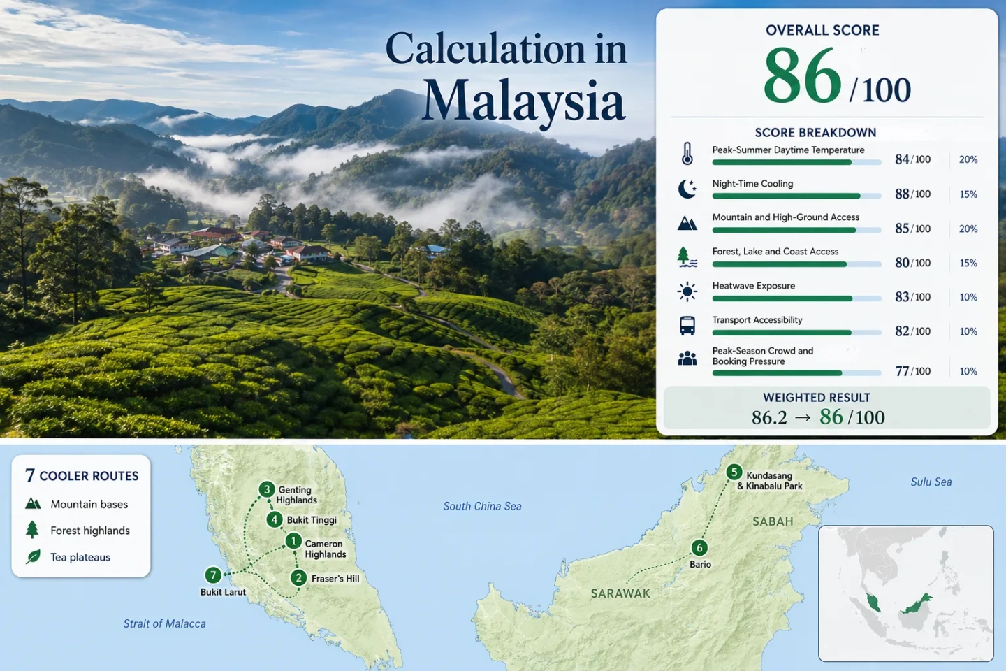
Four Peninsular hill stations, two Borneo highland zones and Bukit Larut are assessed with equal route weighting.
A roughly 1,500-metre plateau combines tea estates, Mossy Forest access and the deepest range of highland town services.
Express buses and the 2.8-kilometre Awana SkyWay create the clearest public-transport climb from the Klang Valley.
The 1,524-metre hill station is oriented toward rainforest walks, birding and quiet roads rather than resort-scale attractions.
Kundasang is reached by mountain road; Bario depends on small-aircraft access and a much more limited local transport network.
Cameron traffic, Genting queues and Kinabalu permit limits can reduce the practical value of otherwise cooler conditions.
From the Titiwangsa Ridge to the Kelabit Plateau
The route set stretches from Pahang’s closely grouped hill stations to isolated highland zones in Sabah and Sarawak. The map is designed for planning orientation rather than turn-by-turn navigation.
Markers show selected highland regions and approximate public location centres, not guaranteed legal parking, trailheads or exact viewpoints. Use the place-specific Google Maps links and current access notices before travelling.
Malaysia Highland Cooler Escape Suitability Score
This transparent editorial suitability index uses disclosed climate, high-ground, landscape, access and pressure factors. It is not an official climate classification or a weather forecast. Route count does not add bonus points; the seven routes are equally weighted and factor results use route medians.
Method: Route-centre July–August mean-maximum benchmark, cross-checked against MET Malaysia station summaries, official elevation descriptions and Tourism Malaysia’s published 16–21°C highland band. Values are editorial proxy inputs rather than direct station normals for every summit or town.
Raw: 23.6°C route median, normalized to 86/100 using the fixed daytime-temperature scale.
Route values: Cameron Highlands 22.7°C; Fraser’s Hill 23.8°C; Genting Highlands 22.9°C; Bukit Tinggi 26.5°C; Kundasang and Kinabalu Park 23.6°C; Bario 27.0°C; Bukit Larut 23.1°C.
Source mapping: Cameron Highlands uses the official Cameron Highlands station context; Kundasang uses Ranau station context plus the higher Kinabalu route elevation; remaining routes use public route-centre coordinates and official elevation checks. Station codes are not published in the cited dashboard.
Period: July–August climatological benchmark aligned to the 1991–2020 normal period where the source system supports it.
Sources: Malaysia Weather and Climate dashboard; MET Malaysia station climate dataset archive; Tourism Malaysia highland climate overview; NASA POWER climatology documentation.
Method: Route-centre July–August mean-minimum benchmark. The factor rewards overnight temperatures in the 10–16°C comfort band and reduces scores as nights move warmer or colder.
Raw: 16.4°C route median, normalized to 97/100 by linear interpolation between 16°C and 18°C.
Route values: Cameron Highlands 15.5°C; Fraser’s Hill 16.4°C; Genting Highlands 16.8°C; Bukit Tinggi 19.3°C; Kundasang and Kinabalu Park 15.8°C; Bario 18.0°C; Bukit Larut 16.1°C.
Source mapping: The same station-context and route-centre hierarchy used for daytime temperature is retained so that day and night values describe the same seven locations.
Period: July–August climatological benchmark aligned to the 1991–2020 normal period where supported.
Sources: Malaysia Weather and Climate dashboard; MET Malaysia station climate dataset archive; Department of Statistics climate summary; NASA POWER temperature parameter definitions.
Method: Fixed elevation-access rubric based on the overnight base or regularly reachable high ground within roughly 60 minutes.
Raw: Route-score median 100.
Route scores: Cameron Highlands 100 — plateau base near 1,500 metres and Gunung Brinchang at 2,032 metres; Fraser’s Hill 100 — base at 1,524 metres; Genting Highlands 100 — resort around 1,800 metres; Bukit Tinggi 80 — base near 800 metres; Kundasang and Kinabalu Park 100 — highland base with direct access to the Kinabalu massif; Bario 100 — settlement zone from about 3,400 feet upward; Bukit Larut 100 — summit station near 1,250 metres.
Period: Access and elevation status reviewed 21 July 2026.
Sources: Tourism Pahang Cameron Highlands profile; Tourism Malaysia Fraser’s Hill profile; Tourism Malaysia Genting Highlands profile; Sabah Tourism Kinabalu Park profile; Sarawak Tourism Bario profile; Tourism Malaysia Perak highland profile.
Method: Fixed physical-access rubric measuring whether substantial forest, lake, river or coast systems can be reached within 30 or 60 minutes. Scenic reputation alone does not increase the score.
Raw: Route-score median 75.
Route scores: Cameron Highlands 100 — montane forest plus reservoir and river systems; Fraser’s Hill 75 — immediate rainforest access; Genting Highlands 75 — forested ridge access; Bukit Tinggi 75 — Titiwangsa forest and garden landscape; Kundasang and Kinabalu Park 75 — immediate protected montane forest; Bario 100 — forested plateau plus river and wet-rice landscape; Bukit Larut 75 — permanent montane forest reserve.
Period: Physical access reviewed 21 July 2026.
Sources: Tourism Pahang Cameron landscape profile; Tourism Malaysia Pahang forest profile; Sabah Tourism Kinabalu trail profile; Sarawak Tourism Bario landscape profile; Tourism Malaysia Bukit Larut forest profile.
Method: Proxy Dataset calculation using the share of July–August daily maximum values at or above 30°C across the latest ten completed target windows. Route-centre series are used where direct highland station daily archives are not exposed through the cited public interface.
Raw: 0.2% route median, normalized to 100/100 under the fixed 0–1% exposure band.
Route values: Cameron Highlands 0.0%; Fraser’s Hill 0.2%; Genting Highlands 0.1%; Bukit Tinggi 2.8%; Kundasang and Kinabalu Park 0.2%; Bario 6.0%; Bukit Larut 0.4%.
Coverage: 620 of 620 expected proxy days per route centre for July–August 2016–2025. This is modeled grid coverage, not a claim of complete direct-station observations.
Coordinates: Cameron 4.471, 101.376; Fraser’s Hill 3.711, 101.736; Genting 3.423, 101.793; Bukit Tinggi 3.350, 101.839; Kundasang 6.015, 116.594; Bario 3.740, 115.478; Bukit Larut 4.861, 100.793.
Period: July–August 2016–2025; daily maximum temperature in degrees Celsius; 30°C threshold.
Sources: NASA POWER daily API documentation; NASA POWER T2M_MAX parameter definition; MET Malaysia climate overview.
Method: Fixed transport rubric considering intercity public transport, the final climb, local mobility and whether a private car is effectively required.
Raw: Route-score median 60.
Route scores: Cameron Highlands 80 — intercity buses reach Tanah Rata but estate and trail movement is less convenient without local transfers; Fraser’s Hill 60 — road access with limited public options; Genting Highlands 100 — frequent buses plus cable car; Bukit Tinggi 60 — straightforward road approach but limited local public mobility; Kundasang and Kinabalu Park 60 — road access and some bus or taxi options, with dispersed sites; Bario 20 — small-aircraft access and highly limited ground transport; Bukit Larut 60 — rail to Taiping followed by taxi and controlled jeep or walking access.
Period: Public access reviewed 21 July 2026.
Sources: Tourism Pahang Cameron transport note; Awana SkyWay operating information; Genting ground transport information; Sabah Tourism Kinabalu access information; Sarawak Tourism Bario flight context; Tourism Malaysia Bukit Larut access note.
Method: Fixed route-pressure rubric using documented congestion, capacity restrictions, transport bottlenecks and the practical need for advance reservations. Higher values indicate lower pressure.
Raw: Route-score median 60.
Route scores: Cameron Highlands 20 — severe weekend and holiday road congestion is documented; Fraser’s Hill 60 — moderate weekend concentration without resort-scale queues; Genting Highlands 20 — high visitor volume and queue exposure; Bukit Tinggi 60 — concentrated day-trip periods; Kundasang and Kinabalu Park 40 — popular lodging plus regulated summit capacity; Bario 80 — low visitor density but scarce flight and room capacity; Bukit Larut 60 — controlled jeep capacity can create a bottleneck.
Period: Current capacity and pressure conditions reviewed 21 July 2026. A uniform three-year occupancy series is not publicly available for all seven routes, which keeps comparability at class C.
Sources: Tourism Pahang Cameron traffic reporting; Sabah Parks Mount Kinabalu booking rules; Sabah Tourism Mount Kinabalu capacity information; Awana SkyWay capacity and operating information; Tourism Malaysia Bukit Larut controlled access note.
Tea Country, Cloud Forests and High-Altitude Town Bases
The seven routes do not deliver the same type of relief. Some are town-based stays with restaurants and buses; others are protected-forest bases, tightly controlled summit gateways or remote communities reached by small aircraft.
Cameron Highlands: Tea Slopes and Mossy Forest Roads
Tanah Rata, Brinchang and the surrounding agricultural plateau form Malaysia’s most complete highland town network. The route combines tea estates, vegetable farms, forest trails and the road toward Gunung Brinchang, which reaches 2,032 metres. The July–August benchmark is approximately 22.7°C by day and 15.5°C at night, creating the clearest balance between cool air and a usable accommodation base.
Intercity buses can reach Tanah Rata, but trailheads, estates and northern attractions are spread along a congested corridor. Weekend and holiday traffic can erase much of the time advantage gained by staying close to the plateau’s main sights.
Fraser’s Hill: Rainforest Trails Above the Selangor Plain
Fraser’s Hill sits in the Titiwangsa Range at 1,524 metres and remains more forest-oriented than Malaysia’s larger resort highlands. The route benchmark is about 23.8°C by day and 16.4°C at night. Short rainforest walks, quiet roads and birding are the main reasons to stay; there is less agricultural sightseeing and fewer indoor attractions than in Cameron Highlands.
The final climb is road-based, and local movement is easier with a car. That lower transport score is partly offset by a compact hill-station footprint once accommodation is secured.
Genting Highlands: Cable-Car Access to an 1,800-Metre Resort Base
Genting offers the most engineered highland access in the route set. The Awana SkyWay covers 2.8 kilometres in roughly ten minutes, rising from the 1,105-metre terminal area to approximately 1,725 metres, while the resort base is commonly described at around 1,800 metres. The benchmark of 22.9°C by day and 16.8°C at night is paired with extensive indoor facilities.
Frequent buses from the Klang Valley and cable-car operation from morning to late evening make a private vehicle unnecessary for the core stay. The trade-off is high visitor volume, queues and a built environment that feels very different from a forest trail or tea-country escape.
Bukit Tinggi: A Lower Titiwangsa Ridge Near Kuala Lumpur
Bukit Tinggi and the wider Berjaya Hills area sit lower than Cameron, Fraser’s and Genting, at roughly 800 metres. The July–August benchmark therefore runs warmer at about 26.5°C by day and 19.3°C at night. The route still gains forest shade, ridge air and a shorter climb from Kuala Lumpur, but afternoon warmth is more noticeable.
The area works as a one- or two-night ridge break rather than a deep-cool highland base. Local public transport is limited, and a car or arranged transfer is usually the practical choice for moving among gardens, viewpoints and accommodation areas.
Kundasang and Kinabalu Park: Mountain Roads Beneath a 4,095-Metre Peak
Kundasang and Kinabalu Park form the strongest large-mountain route in Malaysia. Mount Kinabalu reaches 4,095.2 metres, while the accommodation and park corridor sits far below the summit but still gains substantial elevation above Kota Kinabalu. The route benchmark is approximately 23.6°C by day and 15.8°C at night.
Kinabalu Park has named trails ranging from roughly 2.5 to 5.6 kilometres, allowing forest walking without committing to the summit climb. Reaching the highland corridor takes around two hours by road from Kota Kinabalu under normal conditions. Summit access is separately regulated, online booking is required and daily capacity is limited.
Bario: Kelabit Plateau Nights and Small-Aircraft Logistics
Bario sits in the Kelabit Highlands near the Indonesian border, with villages spread across a plateau commonly described from about 3,400 feet upward. The route is warmer by day than Malaysia’s highest hill stations, with an approximate benchmark of 27.0°C by day and 18.0°C at night, but overnight relief remains meaningful compared with the lowlands.
Access is the defining constraint. Small Twin Otter aircraft connect the plateau with northern Sarawak, and local ground transport is limited. Flight capacity, weather disruption and a small accommodation supply matter more than road congestion. The reward is a landscape of forest, wet-rice fields and dispersed Kelabit villages rather than a purpose-built resort.
Bukit Larut: Controlled Jeep Access Through Montane Forest
Bukit Larut rises above Taiping to around 1,250 metres and is surrounded by a long-protected montane forest. Tourism Malaysia describes a broad daily range of roughly 10–25°C, while the route benchmark for July–August is approximately 23.1°C by day and 16.1°C at night.
Private vehicles do not continue to the summit station. Access depends on the official jeep service or a strenuous uphill walk that can take three to five hours. Taiping is reachable by rail, followed by a short taxi transfer, making the route possible without a car but still dependent on the controlled final ascent.
Why the Titiwangsa Hill Stations Behave Differently
Cameron Highlands, Fraser’s Hill, Genting Highlands and Bukit Tinggi occupy the same broad mountain system, yet elevation, land use and access design produce four distinct travel patterns.
Cameron Is a Working Agricultural Plateau
Tea, vegetables, greenhouses, local traffic and visitor traffic share a narrow north–south corridor. Cooler air is paired with the busiest road environment in the Peninsular route set. Staying within walking distance of Tanah Rata or choosing one side of the plateau for the day can be more valuable than adding another distant stop.
Fraser’s Is a Forest Enclave
The hill station has fewer urban services and less attraction density, but the forest begins close to the accommodation zone. A slow walking day is more natural here than a multi-stop sightseeing circuit. Road access remains the main weakness.
Genting Uses an Engineered Climb
The cable-car system separates the final ascent from mountain-road driving and can carry thousands of passengers per hour. That makes the route unusually accessible, yet the same infrastructure supports high visitor volume and a strongly commercial atmosphere.
Bukit Tinggi Trades Altitude for Proximity
The lower ridge is reached more quickly from Kuala Lumpur but does not retain the same daytime coolness as the 1,500–1,800-metre stations. It is more useful for a short forested break than for travellers prioritising the lowest possible temperatures.
Choosing Between Tea Slopes, Forest Trails and Mountain Towns
All seven assessed routes are included so that cooling strength, access and practical constraints can be compared on the same route set used by the score.
| Route | Base or High Point | July–August Benchmark | Car-Light Viability | Primary Cooling Mechanism | Main Constraint |
|---|---|---|---|---|---|
| Cameron Highlands | Plateau near 1,500 m; Gunung Brinchang 2,032 m | 22.7°C / 15.5°C | Moderate | Plateau elevation, cloud forest and cool nights | Weekend and holiday congestion |
| Fraser’s Hill | 1,524 m hill-station base | 23.8°C / 16.4°C | Limited | Montane forest shade and ridge elevation | Road dependence and fewer services |
| Genting Highlands | About 1,725–1,800 m | 22.9°C / 16.8°C | Strong | High resort elevation and cloud exposure | Queues, visitor volume and commercial setting |
| Bukit Tinggi | About 800 m | 26.5°C / 19.3°C | Limited | Lower ridge air and forest shade | Warmer afternoons during hot spells |
| Kundasang and Kinabalu Park | Highland road corridor below 4,095.2 m Mount Kinabalu | 23.6°C / 15.8°C | Moderate | Massif elevation, montane forest and night cooling | Road time, dispersed sites and summit booking rules |
| Bario | About 3,400 ft and above | 27.0°C / 18.0°C | Very limited | Plateau nights, forest and interior elevation | Small-aircraft capacity and weather disruption |
| Bukit Larut | About 1,250 m | 23.1°C / 16.1°C | Moderate to Taiping; controlled final ascent | Montane forest and summit elevation | Official jeep capacity or long uphill walk |
Kinabalu Road Travel and Bario Flight Logistics Are Not Interchangeable
Kinabalu Is a Road-Based Highland Corridor
Kundasang, Kinabalu Park and nearby viewpoints are linked by the Kota Kinabalu–Ranau road. The travel problem is distance, mountain weather and dispersed stops rather than isolation. A driver provides flexibility, but buses and taxis can cover the main corridor. Summit climbing is a separate, quota-controlled activity and should not be treated as a casual extension of a park visit.
Bario Is Flight-Dependent
The Kelabit plateau is reached primarily by small aircraft, and local capacity is inherently low. A delayed flight can remove a full day, while a sold-out sector can force a different itinerary. Accommodation and onward village transport should be aligned with confirmed flights rather than booked as independent pieces.
July–August Brings Different Rain and Crowd Trade-Offs Across Malaysia
Malaysia’s highlands are not dry-season guarantees. Elevation lowers temperature, but cloud, rain and visibility still vary by mountain system and local exposure.
Peninsular Hill Stations
July and August fall within the southwest monsoon period, which is generally less dominant on the east coast than the northeast monsoon but still produces showers and thunderstorms. Early trail starts preserve more flexibility, especially around exposed tea slopes and Mossy Forest roads. Weekends can be a larger planning problem than rain in Cameron and Genting.
Kinabalu Cloud and Visibility
Mount Kinabalu often develops cloud later in the day. Morning viewpoints and lower park trails are less dependent on summit visibility than a skyline-focused schedule. Road travel should include margin for rain, fog and slower traffic through the highland corridor.
Bario Flight Weather
Rain is not merely a walking inconvenience in Bario; it can affect air access. A remote plateau itinerary works more securely with at least one flexible night and no tightly timed international connection immediately after the return sector.
Live Checks Before Leaving the Lowlands
Weather: Review current warnings and local forecasts through MET Malaysia. Highland temperatures do not remove lightning, heavy-rain or landslide risk.
Kinabalu permits: Summit climbing requires a separate reservation through Sabah Parks; a normal Kinabalu Park visit does not include summit access.
Cable-car and jeep operations: Confirm the Awana SkyWay schedule and current Bukit Larut access arrangements before relying on the final ascent.
Road timing: Avoid treating Cameron Highlands driving times as fixed during weekends, Malaysian school holidays and public-holiday periods. Staying close to the day’s first activity can be more effective than crossing the plateau repeatedly.