Indonesia Beyond Tropical Heat: Volcanic Highlands, Crater Lakes and Cloud Forests
Indonesia’s lowland heat does not describe the whole archipelago. Kerinci’s volcanic valleys, the high lakes of Central Papua and the upper Baliem landscape place overnight bases between roughly 780 and more than 1,700 meters, while selected day routes climb above 3,000 meters. The practical cooling advantage comes from elevation, lake exposure, forest cover and cooler nights, but long road transfers, limited flights and persistent mountain cloud remain central planning constraints.
Two Kerinci routes, two Baliem-area routes and two Central Papua lake routes form the mapped and scored portfolio.
A practical dry-season window for much of the route set, although western Sumatra and Papua can still receive cloud, rain and rapid weather changes.
Median July–August average daily maximum derived from the disclosed NOAA station assignments.
Cooler nights create the clearest separation from Indonesia’s coastal and lowland city climate.
The lake sits above 3,000 meters, far above the Wamena station used as a deliberately conservative warm-side proxy.
Three official stations support six routes, and the two Kerinci assignments have substantial distance and elevation limitations.
Kerinci Caldera Country and Papua’s Lake Highlands
The route set concentrates on places where elevation changes the daily temperature cycle rather than merely adding a short mountain excursion to a hot lowland itinerary.
Markers show selected cooler-route regions and planning centers, not guaranteed legal parking, trailheads or exact viewpoints. Positions are approximate where access roads, permitted stopping points or trail entrances are not specified. Use each route card for Google Maps orientation and confirm local access conditions before traveling.
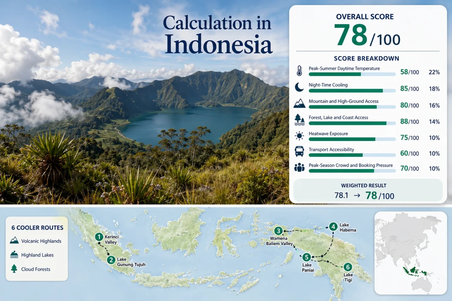
Indonesia Highland Cooler Escape Suitability Score
The score is a transparent editorial suitability index based on disclosed temperature, landscape access, transport and peak-pressure factors. It is not an official climate classification, a weather forecast or a guarantee of comfortable conditions.
The route count does not add points. Each route carries equal weight, and the median route value determines each factor result.
Method: Daily-station calculation. Valid July and August TMAX observations were averaged for each assigned station over 1995–2020. Route values were then ordered and the six-route median was normalized using the fixed daytime-temperature scale.
Raw: Six route values produce a median of 25.6°C. Linear interpolation between 25°C = 75 points and 27°C = 55 points produces 68.7, rounded to 69.
Route values: Sungai Penuh and Kerinci Valley 28.7°C; Kersik Tuo and Lake Gunung Tujuh 28.7°C; Wamena and the Baliem Valley 25.6°C; Lake Habema Highlands 25.6°C; Enarotali and Lake Paniai 23.6°C; Waghete and Lake Tigi 23.6°C.
Source mapping: Kerinci routes use Kerinci/Depati Parbo station IDM00096207 as a regional representative. Wamena is approximately 3 km from station ID000097686; Lake Habema uses the same lower station as a conservative warm-side proxy. Enarotali uses station IDM00097780 directly; Waghete uses it as a nearby highland representative.
Period: July–August station-day observations, 1995–2020. Missing observations were excluded rather than filled. Coverage differs by station, so the results are not presented as complete 1991–2020 climate normals.
Sources: NOAA Global Historical Climatology Network Daily; Kerinci station file; Wamena station file; Enarotali station file.
Method: Daily-station calculation using average valid July–August TMIN observations for the same station assignments and 1995–2020 period. The six-route median was evaluated against the fixed night-cooling scale.
Raw: The median is 14.6°C, within the 10–16°C range that receives 100 points. The factor measures typical overnight relief rather than record-low temperatures.
Route values: Sungai Penuh and Kerinci Valley 17.5°C; Kersik Tuo and Lake Gunung Tujuh 17.5°C; Wamena and the Baliem Valley 14.6°C; Lake Habema Highlands 14.6°C; Enarotali and Lake Paniai 14.3°C; Waghete and Lake Tigi 14.3°C.
Source mapping: Lake Habema’s Wamena value is intentionally conservative because the lake is substantially higher than the station. Kersik Tuo is also higher than its assigned Kerinci station, while the station is geographically distant from the northern Kerinci route center.
Period: July–August station-day observations, 1995–2020, with missing values omitted.
Sources: NOAA GHCN-Daily format and quality documentation; NOAA station metadata; Kerinci observations; Wamena observations; Enarotali observations.
Method: Fixed route rubric based on accommodation-base elevation or regular access to higher ground within approximately 60 minutes. Scores were assigned route by route and the median was used.
Route values and rationale: Sungai Penuh and Kerinci Valley 80 — regional highland base with higher volcanic ground accessible by road; Kersik Tuo and Lake Gunung Tujuh 100 — high accommodation base and direct access to terrain above 1,500 meters; Wamena and the Baliem Valley 100 — base near 1,660 meters; Lake Habema Highlands 100 — destination above 3,000 meters; Enarotali and Lake Paniai 100 — base near 1,770 meters; Waghete and Lake Tigi 100 — highland settlement and lake basin near the Central Range.
Raw: Ordered scores are 80, 100, 100, 100, 100 and 100. The median is 100.
Period: Access and elevation status reviewed July 21, 2026. Elevations from station metadata apply to stations, not every hotel, shoreline or trail point.
Sources: NOAA station elevations; Indonesia Travel Mount Kerinci access information; Indonesia Travel Highland Papua and Lake Habema information; BPK Papua profile of Paniai’s mountain setting.
Method: Fixed physical-access rubric. A route receives 100 when at least two strong elements among extensive forest, a major lake or river system, and a sea coast are reachable within roughly 30 minutes. Scenic reputation alone does not qualify.
Route values and rationale: Sungai Penuh and Kerinci Valley 100 — Lake Kerinci and montane forest access; Kersik Tuo and Lake Gunung Tujuh 100 — rainforest and high caldera lake access; Wamena and the Baliem Valley 75 — strong river-valley access but less immediate large-lake access; Lake Habema Highlands 100 — high lake and montane vegetation; Enarotali and Lake Paniai 100 — major lake system and forested highland margins; Waghete and Lake Tigi 100 — large highland lake and surrounding upland vegetation.
Raw: Ordered route scores are 75, 100, 100, 100, 100 and 100. The median is 100.
Period: Physical landscape access reviewed July 21, 2026. Road, park and local-entry restrictions can change independently of geographic proximity.
Sources: UNESCO Tropical Rainforest Heritage of Sumatra; Indonesia Travel references for Lake Kerinci and Lake Gunung Tujuh; Indonesia Travel Highland Papua landscape information; Official Paniai regional profile.
Method: Daily maximum-temperature threshold calculation. Kerinci and Enarotali use July–August observations from the latest ten completed travel windows, 2015–2024. Wamena uses 2017–2024 because the full ten-window series did not meet the required valid-day coverage threshold.
Coverage: Kerinci 503 valid TMAX days out of 620 expected, 81.1%; Enarotali 543/620, 87.6%; Wamena 446/496 for the disclosed eight-window period, 89.9%. The incomplete Wamena ten-window series was not presented as 0/620.
Route values: Sungai Penuh and Kerinci Valley 23.1%; Kersik Tuo and Lake Gunung Tujuh 23.1% using the same regional station; Wamena and the Baliem Valley 0%; Lake Habema Highlands 0% using Wamena as a conservative lower-elevation proxy; Enarotali and Lake Paniai 0%; Waghete and Lake Tigi 0% using the Enarotali station.
Raw: Ordered route rates are 0%, 0%, 0%, 0%, 23.1% and 23.1%. The median is 0%, corresponding to 100 points under the fixed threshold scale.
Comparability limitation: Wamena’s shorter qualifying period and repeated station assignments reduce comparability. A 100 factor result means the portfolio median has very low observed threshold exposure; it does not mean every route is immune to unusually warm afternoons.
Sources: Kerinci daily observations; Wamena daily observations; Enarotali daily observations; NOAA element and quality-flag documentation.
Method: Fixed accessibility rubric based on the complete journey from a major gateway to the route base, not merely the presence of an airport or road.
Route values and rationale: Sungai Penuh and Kerinci Valley 40 — long overland transfer or limited regional-air connection followed by local road transport; Kersik Tuo and Lake Gunung Tujuh 40 — approximately five to six hours by road from Padang under favorable conditions; Wamena and the Baliem Valley 40 — air-dependent gateway with usable local roads; Lake Habema Highlands 20 — air access to Wamena followed by a condition-sensitive high road and local access arrangements; Enarotali and Lake Paniai 20 — air transport is structurally important and onward options are limited; Waghete and Lake Tigi 20 — remote air and road logistics with limited redundancy.
Raw: Ordered route scores are 20, 20, 20, 40, 40 and 40. The median is 30.
Period: Gateway structure reviewed July 21, 2026. Individual airline schedules, road permissions and local transport departures were not treated as permanent.
Sources: Indonesia Travel road-time information for Mount Kerinci and Kersik Tuo; Indonesia Travel Highland Papua destination information; BPK Papua statement on the importance of air transport in Paniai.
Method: Categorical fallback. A comparable official three-year occupancy or route-capacity series was not available across all six destinations. Scores therefore reflect documented gateway structure, destination prominence and practical accommodation or transport constraints.
Route values and rationale: Sungai Penuh and Kerinci Valley 60 — established domestic destination with finite highland accommodation; Kersik Tuo and Lake Gunung Tujuh 60 — climbing and lake access can concentrate demand around suitable weather; Wamena and the Baliem Valley 60 — regional gateway pressure and event-period demand; Lake Habema Highlands 80 — lower visitor volume but limited vehicles and local arrangements; Enarotali and Lake Paniai 100 — low conventional leisure-tourism pressure; Waghete and Lake Tigi 100 — low visitor volume with logistical scarcity rather than mass-tourism crowding.
Raw: Ordered route scores are 60, 60, 60, 80, 100 and 100. The median is 70.
Interpretation: A high score for the Central Papua routes does not imply easy booking. Limited supply can create difficulty even where visitor numbers remain low.
Period: Destination and gateway conditions reviewed July 21, 2026.
Sources: Indonesia Travel destination prominence references; Indonesia Travel Highland Papua information; Official Paniai transport and regional profile.
Rounded weighted result: 84
The result is driven upward by strong overnight cooling, immediate high-ground access and extensive lake or forest contact. Transport dependence and mixed station comparability prevent the score from functioning as a simple claim that every Indonesian highland route is equally easy or equally cool.
Volcanic Valleys, Caldera Lakes and Central Range Bases
The six destinations separate into three distinct trip structures: long overland travel into Kerinci, air access followed by valley roads around Wamena, and remote lake districts where flight capacity can matter more than visitor volume.
Sungai Penuh and Kerinci Valley
Sungai Penuh works as a service base for Lake Kerinci, tea-country roads and the southern side of the Kerinci volcanic system. It is the warmest member of the scored portfolio, yet nights remain materially cooler than in many Sumatran lowland cities.
The climatic values come from Kerinci/Depati Parbo station IDM00096207. NOAA’s published coordinates place the station roughly 78 km from the mapped Sungai Penuh center, so the numbers should be treated as a regional highland reference rather than a street-level town forecast.
Road access is the main trade-off. A journey from Padang or Jambi can occupy much of a day, and winding mountain roads make arrival time sensitive to weather, traffic and daylight.
Kersik Tuo and Lake Gunung Tujuh
Kersik Tuo places accommodation much closer to Mount Kerinci, tea plantations and the approach to Lake Gunung Tujuh. The lake occupies a high volcanic basin surrounded by forested ridges, producing the clearest combination of the title’s three themes: volcanic high ground, crater-lake water and montane forest.
The Kerinci station used for scoring is approximately 112 km from the mapped Kersik Tuo center and substantially lower than the lake. Its 28.7°C daytime value is therefore a conservative regional proxy that is likely to understate the cooling effect at higher trail and lakeshore elevations.
Cloud and rain remain possible during Indonesia’s broadly drier months. A cool-looking forecast at the accommodation base does not describe wind, exposure or visibility on the lake approach.
Wamena and the Baliem Valley
Wamena offers the strongest balance between direct climate representation and usable highland services in the portfolio. The NOAA station is close to the town, and the July–August daily cycle shows warm but moderated afternoons followed by nights around the mid-teens Celsius.
The valley floor can still feel sunny and warm in the middle of the day. Cooling becomes more apparent after sunset, on higher side roads and during trips toward the Jayawijaya Mountains.
Wamena is reached primarily by air. That removes the multi-hour mountain drive required for Kerinci but introduces fare, baggage and schedule sensitivity. Event periods can also tighten accommodation and seat availability.
Lake Habema Highlands
Lake Habema is not merely a cooler version of Wamena. The road climbs roughly another vertical kilometer and a half beyond the valley station, entering exposed highland terrain where wind, cloud and cold rain can matter more than afternoon heat.
The Wamena climate values are retained in the score to avoid inventing an unsupported lake-level temperature series. Because the station is far lower, they form a deliberately warm-side proxy, not an estimate of actual lakeshore conditions.
Vehicle condition, current road status, local arrangements and permission requirements should be resolved before departure. A blue-sky morning in Wamena does not guarantee stable visibility or a straightforward return from higher ground.
Enarotali and Lake Paniai
Enarotali has the coolest directly assigned daytime station result in the portfolio. The settlement sits beside the Paniai lake system at high elevation, allowing water, forested margins and cool nights to form part of the base rather than requiring a long climb every morning.
The station coordinates match the route center closely, which gives Enarotali a stronger climate-location relationship than the two Kerinci routes. Its limitation is not thermal suitability but travel logistics: regional air service is structurally important, and backup options can be limited.
Lake weather can include cloud, mist and rain even when lowland Indonesia is associated with a broadly dry-season pattern. Warm clothing and rain protection remain useful despite the tropical latitude.
Waghete and Lake Tigi
Waghete extends the Central Papua lake pattern beyond Enarotali. The route uses the nearby Enarotali station because it lies in a comparable highland setting and is approximately 16 km from the mapped center.
The climate proxy is relatively strong by regional standards, but transportation remains fragile. Low visitor density should not be confused with abundant rooms, frequent departures or easy last-minute changes.
Lake Tigi suits a slower itinerary built around one highland district rather than a rapid sequence of Indonesian attractions. Extra schedule margin is more valuable here than adding another distant destination.
Why Equatorial Latitude Does Not Prevent Cool Nights
Indonesia’s highlands do not rely on long summer daylight or northern latitude. Their cooling pattern comes from altitude, exposed lake basins and the loss of daytime heat after sunset.
Kerinci’s Volcanic Gradient
Sungai Penuh and the lower valley remain warm enough for daytime temperatures near the upper twenties Celsius, while Kersik Tuo, Mount Kerinci’s foothills and Lake Gunung Tujuh occupy progressively higher bands. One regional station cannot capture that full vertical range.
The practical result is a route where accommodation choice matters. A room in the lower valley and a room near Kersik Tuo can produce different sleeping conditions even when both are sold as Kerinci stays.
From Baliem Floor to Habema
Wamena already sits near 1,660 meters, yet Lake Habema rises above 3,000 meters. The short map distance conceals a major vertical change, turning a mild highland-town day into a potentially cold and exposed mountain outing.
Temperature, cloud base, wind and road conditions can all change during the ascent. The higher route should be planned as mountain travel rather than an ordinary lake excursion.
Paniai’s High Lake Basins
Enarotali and Waghete begin high rather than requiring a daily climb from the coast. Lake Paniai and Lake Tigi place substantial water bodies inside the inhabited highland system, supporting cool nights and locally persistent cloud.
The trade-off is remoteness. The thermal advantage is present at the base, but reaching that base can require more schedule resilience than a mountain town connected to a national road or rail network.
Six Highland Routes Compared by Climate Evidence and Access
The same six mapped routes are retained so temperature, station quality and transport difficulty can be compared without silently dropping remote destinations.
| Route | Station relationship | July–August max / min | High-ground character | Gateway pattern | Primary trade-off |
|---|---|---|---|---|---|
| Sungai Penuh and Kerinci Valley | Regional Kerinci station; about 78 km from mapped center | 28.7°C / 17.5°C | Highland town with higher volcanic roads | Long road journey or limited regional-air connection | Warmest afternoons in the selected portfolio |
| Kersik Tuo and Lake Gunung Tujuh | Lower regional proxy; about 112 km from mapped center | 28.7°C / 17.5°C proxy | High village, volcano foothills and lake near 1,950 m | Approximately 5–6 road hours from Padang | Weak station comparability but strong physical cooling logic |
| Wamena and the Baliem Valley | Near-direct station; about 3 km | 25.6°C / 14.6°C | Town and valley floor near 1,660 m | Air gateway with local roads | Flight dependence and event-period demand |
| Lake Habema Highlands | Wamena warm-side proxy; about 31 km and far lower | 25.6°C / 14.6°C conservative proxy | High road and lake above 3,000 m | Flight to Wamena followed by arranged road access | Altitude, road condition and weather exposure |
| Enarotali and Lake Paniai | Direct station assignment | 23.6°C / 14.3°C | High settlement beside a major lake system | Air transport with limited alternatives | Low heat but low transport redundancy |
| Waghete and Lake Tigi | Nearby Enarotali proxy; about 16 km | 23.6°C / 14.3°C proxy | High lake basin near 1,700 m | Remote air and road combination | Limited supply despite low visitor pressure |
July–August Does Not Create One Indonesian Mountain Season
The target window improves planning consistency but does not remove Indonesia’s strong regional differences. Mountain cloud, local rainfall and transport reliability remain route-specific.
Kerinci: Drier Roads, Persistent Forest Moisture
July and August can reduce the broad wet-season burden, but Kerinci’s western Sumatran position and forested slopes still support cloud and showers. The lower valley can feel warm in direct sun while higher trails remain wet and misty.
Planning use: Favor early departures and retain a non-summit alternative for days when upper slopes disappear into cloud.
Baliem: Cool Nights and Bright-Afternoon Exposure
Wamena’s station record supports dependable night cooling, but valley-floor sunshine can still produce warm afternoons. Conditions become colder and more exposed toward Lake Habema.
Planning use: Pack for a wide daily range rather than treating the whole route as continuously cold.
Paniai: Lake Cloud and Flight Sensitivity
Enarotali’s temperatures are favorable for avoiding tropical heat, yet lake cloud and rain can limit visibility. Weather also matters before arrival because regional aviation has fewer backup options than Indonesia’s major domestic corridors.
Planning use: Avoid placing an inflexible international departure immediately after the highland segment.
Matching the Highland Base to the Trip’s Main Constraint
Strongest Direct Climate Evidence
Enarotali and Lake Paniai combine a directly assigned high-elevation station, a 23.6°C July–August average maximum, 14.3°C nights and immediate access to a major lake system.
The limitation is transport redundancy rather than summer heat.
Broadest Highland Service Base
Wamena and the Baliem Valley provide the clearest compromise between cool nights, local services, road-based day trips and a station located close to the town.
Air access remains essential, but the base supports more itinerary flexibility than the higher Lake Habema outing.
Strongest Volcanic and Cloud-Forest Combination
Kersik Tuo and Lake Gunung Tujuh align most closely with a volcanic-highland journey, pairing Mount Kerinci’s foothills with a high caldera lake and rainforest trekking.
Its station proxy is the least geographically comparable, so physical elevation and access evidence carry more decision value than the displayed town-level temperature.
Sleeping High Matters More Than Taking One Cool Day Trip
Indonesia’s cooler-route advantage is strongest when the overnight base remains at elevation. A traveler who sleeps in Wamena, Enarotali or Kersik Tuo receives repeated night-time cooling; a traveler who returns to a hot coastal city after one crater-lake excursion receives only a temporary daytime break.
Highland Overnight Bases
Wamena and Enarotali show average July–August minimum temperatures near 14–15°C in the disclosed station data. Rooms may have different insulation, ventilation and hot-water standards than travelers expect from lowland tropical accommodation.
Pack for: Cool indoor mornings, damp clothing and a larger temperature range between midday and dawn.
The Lowland Day-Trip Trap
A crater lake can feel cool for several hours without changing the thermal character of the wider trip. Long descents, traffic and a return to a low-elevation hotel can erase much of the comfort advantage.
Use elevation deliberately: Choose the sleeping base first, then add lakes, forest walks and higher roads around it.
Planning note: The temperature values are portfolio baselines, not substitutes for a current mountain forecast. Recheck aviation, road, park and local-entry conditions shortly before travel, particularly for Lake Habema, Enarotali and Waghete. Remote routes should include schedule margin, warm layers, rain protection and enough flexibility to remain in the gateway town when higher access is unavailable.