The Andes for Cooler Summer Travel: Ecuador to Chile
June through August does not describe one climate from Ecuador to northern Chile. Ecuador enters its drier mountain season, Peru and Bolivia move through the dry Andean winter, and northern Chile is already in austral winter. The practical result is a southbound shift from relatively gentle equatorial highland cooling to frost-prone Altiplano nights and high-desert dawns that can feel fully wintry even when afternoons are sunny.
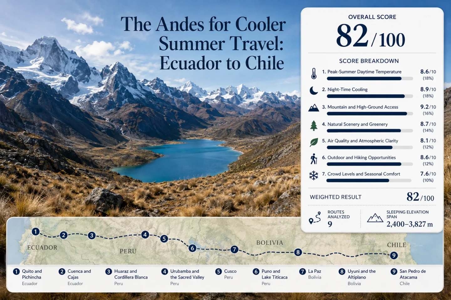
The corridor runs from Quito and Cuenca through Peru and Bolivia to San Pedro de Atacama, using overnight bases rather than isolated summits.
San Pedro de Atacama sits near the lower end; Puno is near the upper end before higher day excursions are considered.
June–August is promoted as mountain season in Ecuador, while the same dates are winter farther south in Bolivia and Chile.
El Tatio exceeds 4,300 m, while Cajas, the Cordillera Blanca and several Altiplano routes also take travelers far above their sleeping base.
A 4,000 m day trip and a 4,000 m overnight stay are not equivalent. The altitude of the bed often matters more than the altitude of the viewpoint.
Around 3,600–3,800 m, heat avoidance becomes a cold-management problem, especially before sunrise and after sunset.
From Equatorial Highlands to the Atacama Altiplano
The route is better understood as a chain of overnight climate bases than as a single north-to-south temperature gradient. Each marker represents a practical planning center with access to higher terrain.
Markers show planning centers rather than exact viewpoints, trailheads or legal parking points. High-altitude excursions can begin far from the marker and finish thousands of vertical metres above the overnight base.
Nine Overnight Bases That Change the Meaning of Summer
The same June–August trip can begin with cool, springlike city afternoons and end with pre-dawn sub-zero exposure. The useful comparison is not simply north versus south; it is sleeping elevation + local season + day-trip elevation + night-time cooling.
Quito and Pichincha: Equatorial Cooling Without Altiplano Winter
Quito is almost on the equator, yet its elevation keeps July and August afternoons far below tropical lowland heat. Existing Cooler Escapes climate work for the city uses roughly 19°C daytime and 9°C night-time conditions for July–August, a combination that remains cool without making freezing nights the defining feature.
Pichincha changes the exposure quickly. Cable-car and mountain routes reach much higher terrain, so a comfortable city morning can turn into wind, strong ultraviolet exposure and much colder air within the same day. Returning to a 2,850 m sleeping base is a very different altitude load from continuing upward to sleep on the high plateau.
Cuenca and Cajas: Páramo Cold Feels Different From Dry Highland Cold
Cuenca sits lower than Quito but still retains cool highland temperatures. The nearby Cajas landscape adds a different mechanism: exposed páramo, lakes, cloud, wet ground and wind. A temperature that looks moderate on paper can feel substantially colder when mist and moving air replace the dry, sunny conditions common farther south.
This is one of the clearest points on the corridor where “dry” and “cool” should not be treated as synonyms. Cajas can deliver wet cold while Peru and Bolivia later deliver dry cold. The gear problem changes even when the thermometer does not change dramatically.
Huaraz and Cordillera Blanca: The First 3,000-Metre Mountain Base
Huaraz changes the route scale. The city itself is already around 3,091 m, while access roads and trailheads climb rapidly into the Cordillera Blanca. Peru’s official visitor climate material lists Huaraz with an approximate 18°C maximum and 0°C minimum as a broad destination reference; it should not be read as a June–August station normal, but it captures the size of the day-night contrast.
Long-distance road travel from Lima is the common approach, followed by local transfers toward mountain valleys and trailheads. That makes Huaraz a strong example of a place where the overnight base is high, but the mountain day can be much higher still.
Urubamba and the Sacred Valley: A Lower Bed Before Cusco
Urubamba is not merely a sightseeing stop between Cusco and Machu Picchu. Its elevation makes it a practical sleeping-altitude step. The valley floor is roughly half a vertical kilometre below central Cusco, while June–July daytime conditions can still rise above 20°C and nights can drop close to freezing.
Road transport links Pisac, Urubamba and Ollantaytambo, while the rail corridor becomes important farther west. The useful distinction is that a lower valley bed can reduce overnight altitude exposure without removing access to high passes, archaeological sites and mountain day trips.
Cusco: Mild Midday Temperatures Can End in a Frosty Dawn
Cusco is where the weakness of a single “average temperature” becomes obvious. A representative June–July pattern around 20.6°C by day and -1.3°C at night describes two different travel experiences: sunlit plazas can feel mild, while pre-dawn streets and unheated rooms can feel wintry.
The city is also a transport hub, which makes it easy to arrive before the body has adjusted to sleeping above 3,000 m. Moving first through a lower Sacred Valley base can change that sequence without removing Cusco from the route.
Puno and Lake Titicaca: The Point Where Cool Becomes Cold
At Lake Titicaca, the route stops behaving like a mild highland escape. June–July daytime temperatures around 14°C and nights below freezing make cold a central part of the trip rather than a side effect. The lake’s intense high-altitude sunlight can still create bright, comfortable-looking afternoons, but shade, open-water wind and sunset change perceived temperature quickly.
Puno also marks a logistics transition. Arrivals may involve long-distance coaches, rail services or a transfer from Juliaca. Because the sleeping elevation is already around 3,800 m, the accommodation itself—not only a mountain excursion—becomes an altitude decision.
La Paz and Cordillera Real: One City, Several Elevation Bands
La Paz turns altitude into an urban-scale climate gradient. Central areas sit deep in a steep basin, while El Alto occupies the exposed plateau roughly 400 m higher. The difference can be felt in wind, night-time cold and the physical effort of moving around, even before a Cordillera Real excursion is added.
Mi Teleférico makes this vertical geography unusually visible: a single urban journey can move between valley-facing neighborhoods and the high plateau without a long road detour. For cooler-summer planning, that means hotel location can affect comfort in a way that a single “La Paz elevation” cannot describe.
Uyuni and Southwest Altiplano: Heat Escape Becomes Thermal Extremes
Uyuni’s official tourism material places the salar around 3,663 m and gives a broad climate range extending from below freezing to mild daytime values. That range matters more than a single mean because the dry air and open sky allow rapid radiative cooling after sunset.
The town or salar overnight should be separated from a multi-day Southwest Altiplano circuit. High lagoons, geyser fields and border routes can spend long periods above 4,000 m, with very early starts and much colder exposure than the base town suggests.
San Pedro de Atacama and El Tatio: A Lower Desert Base With a Winter Dawn Above 4,300 Metres
San Pedro reverses a common assumption about the southbound route: the sleeping base drops by more than a kilometre compared with Puno, yet the cold problem does not disappear. The Atacama’s very dry air creates a large day-night swing, and the classic El Tatio departure begins before sunrise at more than 4,300 m.
Current Chilean tourism guidance highlights April through June as a particularly useful San Pedro window because summer-rain disruption has usually eased while visitor pressure is lower than in major holiday periods. By July and August, the desert base can still produce sunny afternoons, but high-Altiplano dawns sit deeper in austral winter. El Tatio guidance warns that extreme early-morning cold can approach -20°C.
One Mountain Chain, Four June–August Climate Regimes
The Andes do not simply become colder with latitude. The type of cooling changes as latitude, elevation, humidity and seasonal circulation change together.
Ecuadorian Andes: Elevation and Páramo
Ecuador’s current tourism calendar identifies June–August as Mountain Season. Quito and Cuenca remain equatorial, so the cooling comes mainly from elevation rather than a conventional winter. Higher páramo adds cloud, wind and wet exposure, especially around Cajas.
Peruvian Andes: Dry-Season Sun, Frost-Prone Nights
Huaraz, Cusco and Puno sit in the dry Andean winter. Clear skies improve mountain visibility but also allow strong night-time heat loss. The corridor can therefore pair 20°C-class afternoons in Cusco or the Sacred Valley with temperatures near or below freezing before dawn.
Bolivian Altiplano: High Plateau Before Any Excursion Begins
La Paz and Uyuni move the sleeping base itself into roughly the 3,600 m band. Low humidity, open terrain and a high plateau make the day-night swing a defining travel condition rather than an occasional mountain effect.
Northern Chile: Austral Winter in a Hyper-Arid Desert
San Pedro is lower than the Bolivian plateau, but June–August is winter. Strong solar heating can make afternoons look benign while 4,000 m+ excursions face frost, wind and severe pre-dawn cold.
Nine Bases by Sleeping Elevation, Cold Pattern and High-Ground Reach
Temperature values are shown only where a useful route-level reference is available. Periods are stated because Ecuador’s July–August figures, Peru’s June–July figures and broad visitor climate ranges are not one uniform climatology.
| Overnight base | Sleeping elevation | Cold-season signal | Higher terrain | Transport pattern | Main trade-off |
|---|---|---|---|---|---|
| Quito and Pichincha | ~2,850 m | ~19°C / 9°C, July–August | 4,000 m+ nearby | Metro, bus, road excursion | UV, wind and rapid altitude gain |
| Cuenca and Cajas | ~2,540 m | ~18.5°C / 7.5°C, July–August | Cajas passes above 4,000 m | Air/coach base, road to Cajas | Fog, wet cold and exposed wind |
| Huaraz and Cordillera Blanca | ~3,091 m | 18°C / 0°C broad visitor reference | Frequent 4,000 m+ terrain | Long-distance coach + local transfers | High sleeping base before trek elevation |
| Urubamba and the Sacred Valley | ~2,850 m | ~22.3°C / 2.4°C, June–July | High passes and mountain sites | Road corridor + nearby rail | Cold nights despite mild afternoons |
| Cusco | ~3,399 m center | ~20.6°C / -1.3°C, June–July representative station | Multiple 4,000 m+ routes | Airport, bus and regional road hub | Frosty dawns at a high overnight base |
| Puno and Lake Titicaca | ~3,810 m | ~14.1°C / -1.1°C, June–July | Altiplano already surrounds the base | Coach, rail, Juliaca transfer | Cold becomes a full-day planning factor |
| La Paz and Cordillera Real | ~3,600–3,650 m | Strong urban elevation gradient | El Alto ~4,050 m; higher Cordillera beyond | Airport, bus, Mi Teleférico | Hotel neighborhood changes altitude exposure |
| Uyuni and Southwest Altiplano | ~3,663 m | About -4°C to 21°C broad tourism range | 4,000–5,000 m on southwest circuits | Flight, bus, Oruro rail | Very large day-night and base-excursion gap |
| San Pedro de Atacama and El Tatio | ~2,400–2,450 m | High-desert winter with large diurnal swing | El Tatio above 4,300 m | Calama road transfer + excursion vehicle | Pre-dawn high-altitude cold far below town expectations |
The Sacred Valley Changes the Sleeping-Altitude Equation
Urubamba Keeps the Bed Near 2,850 Metres
Urubamba sits roughly 550 m below central Cusco. That difference is large enough to matter operationally: a traveler can reach the Cusco region, spend the first nights in the valley, and still access Pisac, Ollantaytambo and high mountain routes without making 3,399 m the first sleeping altitude.
The trade-off is temperature, not warmth. June–July nights around 2–5°C remain cold, so the valley is a lower highland base, not a low-elevation refuge.
Cusco Adds Altitude Before It Adds Heat Relief
Moving from Urubamba to central Cusco raises the sleeping altitude by roughly half a vertical kilometre while daytime temperatures remain in a similar mild range. The major change is the night: representative June–July minima can fall below freezing.
That makes the valley-to-Cusco sequence more useful than ranking the two places only by afternoon temperature. The cooler base is not automatically the easier base.
Lake Titicaca and La Paz Mark the Altiplano Threshold
Titicaca: Bright Sun, Cold Air
Lake Titicaca sits around 3,810 m. Dry-season skies can be intensely bright while the air remains cool, and open-water wind removes the sheltered feeling that may exist in a valley. The lake therefore separates solar warmth from air temperature more clearly than lower Andean cities.
La Paz: A Vertical City Rather Than One Elevation
The urban basin around 3,600–3,650 m rises toward El Alto near 4,050 m. Mi Teleférico crosses that vertical difference directly, so exposure can change during an ordinary urban trip. A hotel in a lower neighborhood and an arrival through El Alto airport do not represent the same thermal or altitude experience.
Cordillera Real: High Ground on Top of a High Base
By La Paz, the route no longer needs a mountain excursion to reach high altitude; the city has already done that. Cordillera Real days add another layer above an overnight base that is itself high enough to require deliberate pacing.
Uyuni and San Pedro Need Two Separate Temperature Expectations
Uyuni Town Is Not the Southwest Altiplano Circuit
The salar averages about 3,663 m, already high enough for freezing nights. Multi-day routes toward high lagoons and geothermal areas climb into the 4,000–5,000 m band, often with long exposed drives and sunrise departures. A packing plan based on an afternoon in Uyuni town will understate the cold encountered on the circuit.
San Pedro Is Not El Tatio Before Sunrise
San Pedro’s base near 2,400–2,450 m is substantially lower than Uyuni, Puno or La Paz. El Tatio is more than 4,300 m and roughly 80 km away, with departures timed for the coldest part of the day. The excursion can approach extreme sub-zero temperatures even when the previous afternoon in town felt mild.
Sleeping Elevation Matters More Than the Highest Viewpoint
The corridor can be divided into practical overnight bands. These are not medical thresholds or guarantees; they show how quickly a cool-weather trip becomes a high-altitude trip.
About 2,400–2,900 m: Softer Highland Bases
San Pedro, Cuenca, Quito and Urubamba sit in this band. Nights can be cold, but the overnight altitude is materially lower than Cusco, Puno, La Paz or Uyuni.
About 3,000–3,500 m: Strong Cooling, Higher Overnight Load
Huaraz and Cusco combine cool or mild afternoons with much colder nights. The sleeping altitude is high enough that pacing becomes part of route design rather than an optional consideration.
About 3,600–3,830 m: Cold Is Part of the Stay
La Paz, Uyuni and Puno occupy the high plateau range. Frost, dry air and strong ultraviolet exposure can all occur without leaving the overnight destination.
Above 4,000 m: Day-Trip Terrain Requires Its Own Plan
Cajas high passes, Cordillera Blanca routes, Altiplano circuits and El Tatio all push beyond the base climate. A short visit at this elevation is not equivalent to sleeping there.
June, July and August Do Not Trade the Same Way
A single “Andes summer” label hides opposite seasons. June is often the cleanest compromise for the entire Ecuador-to-Chile corridor, while July and August move the southern half deeper into austral winter.
| Planning factor | June | July | August |
|---|---|---|---|
| Ecuadorian Andes | Mountain Season begins; generally drier highland conditions become more useful for volcano and páramo days. | Strong mountain-season fit with cool city bases and high-excursion options. | Mountain-season pattern continues; wind and exposed páramo conditions still matter. |
| Peruvian Andes | Dry-season visibility strengthens; nights are already cold. | Very dry highland travel window, with severe dawn cooling at Cusco and Puno elevations. | Dry-season advantages continue, but high-altitude night cold remains central. |
| Bolivian Altiplano | Dry winter conditions; freezing nights become routine at high bases. | Deep winter exposure on the plateau and early-morning excursions. | Still cold and dry; wind and large diurnal swings remain important. |
| San Pedro and northern Chile | Falls inside the April–June window currently highlighted by Chilean tourism for clearer routes after summer rains and lower visitor pressure. | Sunny desert days remain possible, but 4,000 m+ excursions sit deeper in winter. | High-desert sun still masks cold mornings; excursion temperature gaps remain large. |
| Whole-corridor logic | Most balanced compromise: Ecuador’s mountain season is active while northern Chile has not moved as far into winter as July–August. | Stronger dry-season consistency, but a colder southern half. | Still workable for dry highland travel, with no reduction in the need for cold-night planning. |
Afternoon Comfort and Night-Time Cold Need Separate Decisions
A trip built only from daytime maxima can look deceptively mild. Quito’s July–August pattern of roughly 19°C by day and 9°C at night is a relatively balanced cool-city climate. Urubamba can be warmer in the afternoon at roughly 22.3°C yet fall near 2.4°C at night. Cusco can reach about 20.6°C by day while a representative station drops below freezing, and Puno can remain around 14.1°C even before the night falls to roughly -1.1°C.
The southbound change is therefore not “warm to cold” in a simple line. It is a widening separation between solar afternoon comfort and radiative night cooling, amplified by higher sleeping elevations and increasingly dry winter air.
Ecuadorian Páramo Cold
Moisture, cloud, wind and exposed grassland can make Cajas or high volcano routes feel colder than a dry thermometer reading suggests.
Peruvian and Bolivian Dry Cold
Clear skies favor warm sunlit surfaces by day and rapid heat loss at night. Shade and pre-dawn conditions can feel dramatically colder than midday.
Atacama High-Desert Cold
Very low humidity and clear skies magnify the day-night swing, while excursions above 4,000 m add altitude and wind to the winter cold.
Where the Andes Stop Being a Mild Escape and Become a Cold-Weather Trip
Ecuador provides the gentlest entry into the corridor: Quito and Cuenca use elevation to suppress heat while keeping overnight conditions comparatively moderate. Peru introduces a larger day-night gap. Huaraz and Cusco can still deliver mild sunny afternoons, but freezing or near-freezing dawns become realistic, and the Sacred Valley becomes valuable because it lowers the sleeping altitude without abandoning the highlands.
Lake Titicaca is the clearest threshold. From Puno through La Paz and Uyuni, the overnight base itself sits high enough that frost, dry air and altitude are inseparable from the trip. San Pedro then lowers the bed to roughly 2,400–2,450 m, but northern Chile does not return to a simple mild climate: austral winter and 4,300 m+ excursions recreate severe cold on a daily outing.
The useful Andes strategy is not to chase the lowest temperature. Match the route to the cold actually wanted, keep the sleeping-elevation progression deliberate, and separate town conditions from high-altitude excursion conditions. That produces a cooler summer journey without turning every stop into a test of how much cold or altitude can be tolerated.