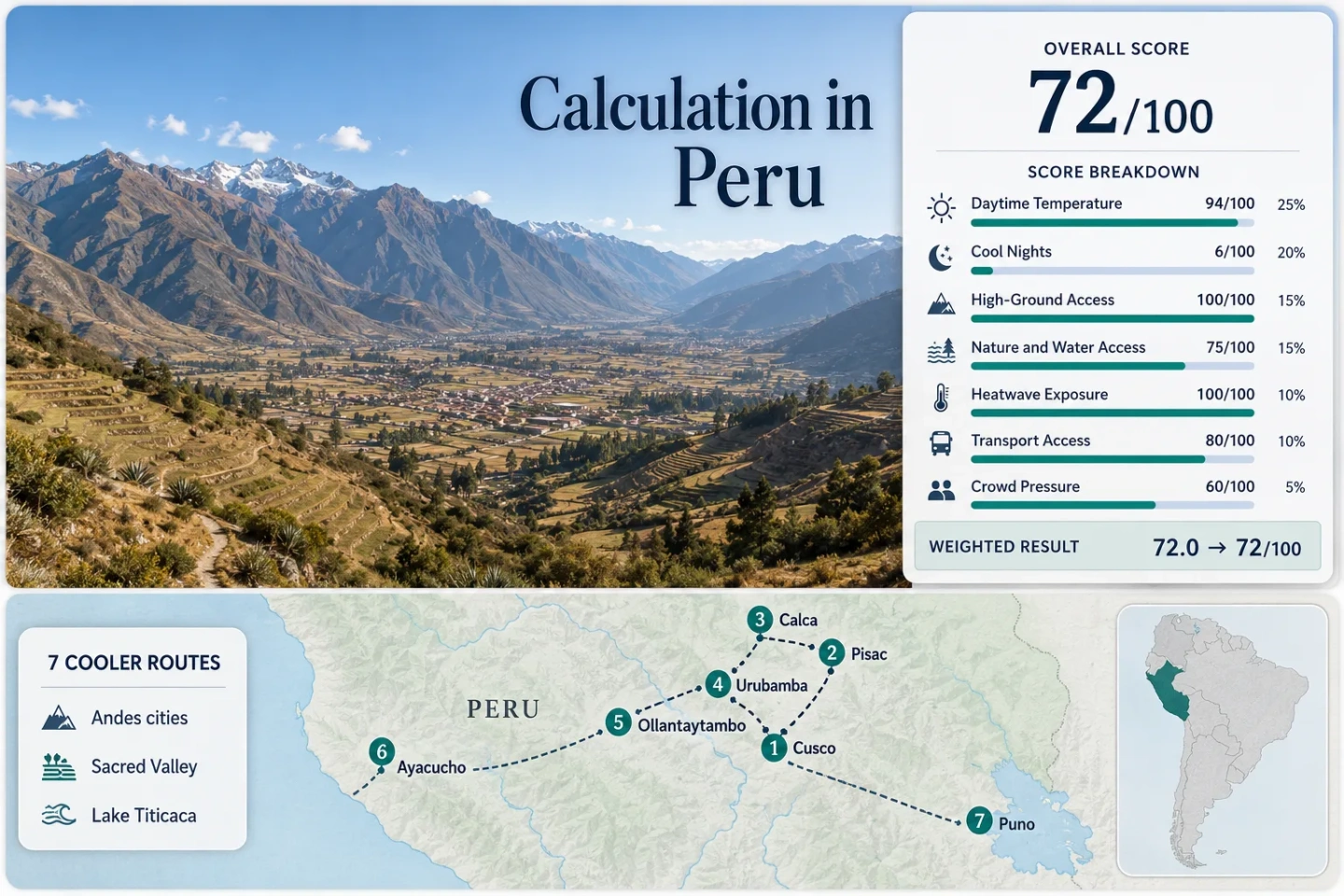
Peru for Mild Highland Travel: Andes Cities, Sacred Valley and Cool Nights
High elevation does most of the cooling work across this route set. Cusco and the Sacred Valley pair mild, sunny dry-season afternoons with sharply colder nights, while Puno lowers daytime heat further beside Lake Titicaca. The central trade-off is not oppressive heat but altitude, frost-prone mornings and limited rail capacity around the Ollantaytambo corridor.
Cusco, four Sacred Valley towns, Ayacucho and Puno form the shared map, score and comparison set.
Derived from official 1981–2010 station normals for the seven selected bases.
Dry-season nights frequently require insulation rather than simple light layers.
Lake Titicaca’s 3,812-metre station averages about 14.1°C by day in June–July.
Airport access, shared road transport and rail from Ollantaytambo support a multi-base trip without a rental car.
Cold dawns, rapid elevation gain and June–August train demand matter more than midday heat.
Andean City Bases from Ayacucho to Lake Titicaca
The markers separate the Cusco–Sacred Valley cluster from stand-alone Ayacucho and Puno stays.
This marker map is built for planning orientation. Marker positions use approximate public location centers where exact viewpoints, trailheads, legal parking areas or pull-offs are not specified. Markers show selected highland bases, not guaranteed legal parking or exact entrances. Use each route card for Google Maps links and access notes before traveling.
Peru Highland Escape Suitability Score
This transparent editorial index uses disclosed climate, landscape, access and pressure factors. It is not an official climate classification or forecast. Every selected base carries equal weight before the route median is calculated.
Method: Median of each route’s June–July mean daily maximum, normalized with the fixed daytime-temperature scale.
Raw: 22.25°C median; interpolation between 21°C and 23°C gives 93.75, rounded to 94/100.
Route values: Cusco 20.6°C; Pisac 22.8°C; Calca 22.8°C; Urubamba 22.25°C; Ollantaytambo 22.25°C; Ayacucho 23.15°C; Puno 14.05°C. Median: 22.25°C.
Source mapping: Cusco uses representative Granja Kcayra 100044; Pisac uses direct Pisac 100101; Calca uses Pisac, about 18 km away with little elevation difference; Urubamba uses direct Urubamba 113034; Ollantaytambo uses Urubamba, about 17 km away and roughly 58 m higher; Ayacucho uses near-city Huamanga 113019; Puno uses direct Puno 100110.
Period: Official 1981–2010 air-temperature normals; June and July values averaged per route.
Sources: SENAMHI station tables and monthly normals; SENAMHI atlas publication record.
Method: Median of June–July mean daily minimum temperatures. The rubric rewards sleep-friendly 10–16°C nights and penalizes nights that are too cold as well as too warm.
Raw: 2.4°C median; interpolation between 2°C and 4°C gives 6/100.
Route values: Cusco −1.3°C; Pisac 4.55°C; Calca 4.55°C; Urubamba 2.4°C; Ollantaytambo 2.4°C; Ayacucho 5.45°C; Puno −1.1°C. Median: 2.4°C.
Source mapping: The daytime-temperature station mapping is retained for internal consistency.
Period: Official 1981–2010 air-temperature normals; June and July values averaged per route.
Sources: SENAMHI station tables and monthly normals; SENAMHI atlas publication record.
Method: Fixed categorical rubric. A lodging base at 900 m or higher scores 100.
Raw: Every route clears the highest threshold; route-score median 100/100.
Route scores: Cusco 100 — highland city base; Pisac 100 — 2,950 m station; Calca 100 — high Sacred Valley floor; Urubamba 100 — 2,850 m station; Ollantaytambo 100 — high valley base; Ayacucho 100 — 2,761 m station; Puno 100 — 3,812 m station. Median: 100/100.
Period: Access and base-elevation status reviewed 15 July 2026.
Sources: SENAMHI station inventory with elevations; Peru’s official tourism portal for destination context.
Method: Fixed physical-access rubric based on reaching a large river system, lake, broad forest or coast within 30 or 60 minutes.
Raw: Route-score median 75/100.
Route scores: Cusco 45 — river and green-valley access within about 60 minutes; Pisac 75 — Urubamba River within 30 minutes; Calca 75 — river corridor within 30 minutes; Urubamba 75 — river corridor within 30 minutes; Ollantaytambo 75 — river and valley access within 30 minutes; Ayacucho 45 — limited highland river access; Puno 75 — Lake Titicaca within 30 minutes. Median: 75/100.
Period: Physical-access status reviewed 15 July 2026.
Sources: Peru National Water Authority; Peru’s official tourism portal. These broad official references are used because no single national page publishes one comparable travel-time table for all seven bases.
Method: Proxy Dataset calculation from NOAA Global Summary of the Day maximum temperature. A hot day is MAX ≥30°C during June–July 2016–2025; each route must retain at least 80% of 610 expected days.
Raw: Zero qualifying days in every retained series; route median 0%, normalized to 100/100.
Route values: Cusco 0/610; Pisac 0/610; Calca 0/610; Urubamba 0/610; Ollantaytambo 0/610; Ayacucho 0/610; Puno 0/560 valid days. Median: 0%.
Source mapping: Cusco Airport station 84686099999 is direct for Cusco and representative for Pisac, Calca, Urubamba and Ollantaytambo; it is roughly 32–62 km away and about 360–518 m higher than those valley bases. Ayacucho Airport 84673099999 is near-city. Juliaca Airport 84735099999 represents Puno from about 44 km away at similar elevation. Coverage: 100% for Cusco/Ayacucho mappings and 91.8% for Puno.
Period: 1 June–31 July in the ten completed years 2016–2025; 610 expected days per station mapping.
Sources: NOAA NCEI surface-data product description; NOAA daily-data archive.
Method: Fixed categorical rubric based on direct public transport, transfer complexity and whether a private car is required.
Raw: Route-score median 80/100.
Route scores: Cusco 100 — direct airport and urban transport; Pisac 80 — regular road transport from Cusco in under two hours; Calca 80 — regular valley road transport; Urubamba 80 — regular road connections; Ollantaytambo 80 — road plus rail station; Ayacucho 100 — direct airport and coach access; Puno 80 — Juliaca transfer plus coach and rail options. Median: 80/100.
Period: Published access pattern reviewed 15 July 2026; schedules remain date-sensitive.
Sources: CORPAC airport information; PeruRail Sacred Valley access information; PeruRail station and travel recommendations.
Method: Official-capacity fallback using ticket limits, rail demand and recurring reservation signals because comparable lodging occupancy is unavailable.
Raw: Route-score median 60/100.
Route scores: Cusco 40 — gateway pressure and June events; Pisac 60 — regular day-trip concentration; Calca 80 — lower capacity pressure; Urubamba 60 — recurring high-season lodging demand; Ollantaytambo 20 — rail-gateway and ticket-capacity pressure; Ayacucho 80 — lower June–July reservation pressure; Puno 80 — lower pressure than the Cusco corridor. Median: 60/100.
Period: Capacity and reservation evidence reviewed 15 July 2026.
Sources: Ministry of Culture Machu Picchu ticket-capacity notice; PeruRail travel recommendations. The fallback measures access pressure, not a claimed occupancy percentage.
Cusco Basin, Sacred Valley Towns and Southern Plateau Bases
Five bases form a compact Cusco–Sacred Valley corridor; Ayacucho and Puno work as separate city stays.
Cusco as a High-Altitude Urban Base
Cusco combines direct air access with a June–July station average near 20.6°C by day. The same normal drops below freezing at night, so the city earns strong daytime marks but poor sleep-temperature marks. Use the first day for acclimatization rather than immediately stacking steep walks or high passes.
Pisac for a Warmer Sacred Valley Night
Pisac’s official station averages about 22.8°C by day and 4.6°C at night in June–July. That remains cold, but it is materially softer than Cusco’s sub-zero normal. The town suits travelers who want valley-floor acclimatization with easy road access back to Cusco.
Calca for a Functional Valley Stay
Calca sits on the same Urubamba corridor as Pisac but functions more as a local service town than a rail gateway. Pisac station is the representative climate source: about 22.8°C by day and 4.6°C at night. It works well when lower booking pressure matters more than rail convenience.
Urubamba for a Central Valley Position
Urubamba places Pisac and Ollantaytambo on opposite sides of the same valley trip. Its official June–July averages are about 22.3°C by day and 2.4°C at night. The central position helps multi-town planning, but cold dawns remain a defining feature despite the lower base than Cusco.
Ollantaytambo for Rail-Linked Valley Nights
Ollantaytambo is the strongest rail-linked base in the portfolio. Urubamba station represents its climate at about 22.3°C by day and 2.4°C at night. The advantage is logistical; the penalty is June–August booking pressure tied to Machu Picchu trains and timed-entry demand.
Ayacucho for Milder Highland Nights
Ayacucho is the warmest daytime base in the set but also has the gentlest June–July night normal, about 5.5°C. It suits a city-focused highland stay where frost risk is lower than Cusco or Puno. The trade-off is geography: it is not a quick overland add-on to the Sacred Valley.
Puno for the Lowest Daytime Heat
Puno produces the clearest low-heat signal: roughly 14.1°C by day in June–July. Nights average below freezing, and the city’s elevation raises acclimatization demands. Lake access is immediate, while arrival usually requires a Juliaca airport transfer, a long-distance coach or a scheduled rail journey.
The Cusco Basin Versus the Urubamba Valley Floor
A short road transfer can lower sleeping elevation by several hundred metres without turning the trip hot.
Cusco Front-Loads Altitude
The historic center is around 3,399 m, while the representative climate station is lower at 3,219 m. Starting here maximizes urban convenience but also places the steepest acclimatization demand at the beginning of the trip.
The Valley Softens, Not Removes, Cold
Pisac, Calca, Urubamba and Ollantaytambo sit roughly 450–600 m below central Cusco. Their June–July night normals still range near 2–5°C, so lower elevation should not be mistaken for warm evenings.
Road Flexibility Ends at the Rail Decision
Shared road transport links the valley towns, but the Machu Picchu rail segment creates a fixed-capacity decision around Ollantaytambo. Staying elsewhere may lower pressure, yet it adds an early road transfer before the train.
Seven Bases, One Dry-Season Decision Matrix
Values are station normals, not forecasts; Calca and Ollantaytambo use disclosed representative stations.
| Base | June–July max | June–July min | Elevation signal | Access pattern | Main trade-off |
|---|---|---|---|---|---|
| Cusco | 20.6°C | −1.3°C | 3,219 m station; higher center | Direct airport and urban transport | Freezing dawns and rapid altitude gain |
| Pisac | 22.8°C | 4.6°C | 2,950 m station | Regular road transport from Cusco | Day-trip concentration |
| Calca | 22.8°C | 4.6°C | About 2,930 m base | Valley road corridor | No main tourist rail station |
| Urubamba | 22.3°C | 2.4°C | 2,850 m station | Central road hub | Very cold dry-season nights |
| Ollantaytambo | 22.3°C | 2.4°C | About 2,790 m base | Road and rail gateway | Rail and timed-entry capacity |
| Ayacucho | 23.2°C | 5.5°C | 2,761 m station | Direct airport and coach access | Long overland connection to Cusco |
| Puno | 14.1°C | −1.1°C | 3,812 m station | Juliaca transfer, coach or rail | Severe altitude and frost |
Rail Capacity, Frost Mornings and Acclimatization
Lock the Rail Segment Before the Valley Sequence
Ollantaytambo’s value depends on a dated train and a compatible Machu Picchu entrance. Build the Sacred Valley order around confirmed capacity, then choose Pisac, Calca or Urubamba as the flexible road-linked nights.
Pack for a Two-Season Day
Sunny afternoons can sit in the low 20s°C while dawn temperatures approach or cross freezing. A warm sleep layer, insulated outer layer, sun protection and water matter more than a single “mild weather” outfit.
Use Lower Valley Nights Strategically
Travelers arriving from low elevation can sleep first in the Sacred Valley, move to Cusco after acclimatization, and reserve Puno for later. This ordering reduces the chance of stacking the highest bases at the start.