Ecuador Summer Escapes: Volcano Towns, Highland Cities and Springlike Weather
Ecuador’s Andean spine replaces lowland heat with high-elevation city bases, cool nights and fast access to páramo landscapes. From Quito and Otavalo to Cuenca and Loja, the practical advantage comes from sleeping between roughly 2,060 and 2,850 metres, then climbing higher toward crater lakes, volcanic reserves and cloud forest without committing every day to a remote mountain lodge.
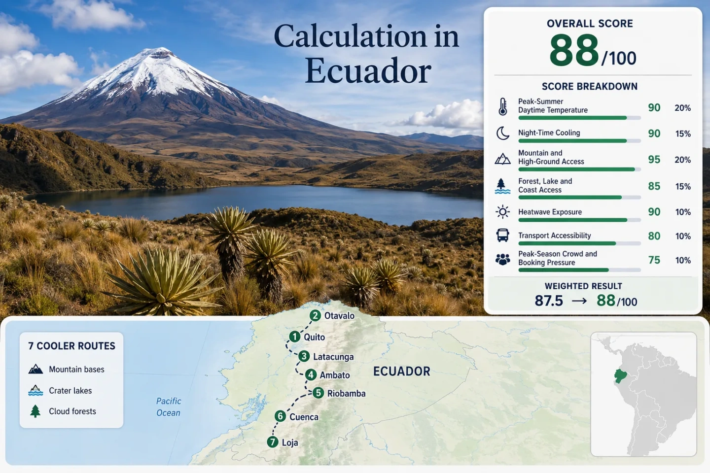
The same seven places appear in the map, score evidence, destination portfolio and comparison matrix.
Every route begins above 2,000 metres, so altitude shapes the whole trip rather than a single day excursion.
The route-set median uses official or representative highland station records with mixed published periods.
Cool nights are reliable, but rooms without heating can feel colder than the daytime figures suggest.
Metro, bus corridors and direct intercity links make the capital the strongest low-car starting point.
A highland city base connects quickly with Cajas lakes, cloud forest and a road crest above 4,000 metres.
Check official volcanic bulletins, protected-area notices and road conditions before high-altitude departures.
The Andes Corridor from Otavalo to Loja
The route set follows Ecuador’s inter-Andean basin and southern highlands, linking city services with nearby volcanic slopes, crater lakes, páramo and cloud forest.
This marker map is built for planning orientation. Markers use approximate public location centres, not guaranteed legal parking, trailheads or exact viewpoints. Use the named Google Maps links and current access notices before travelling.
Ecuador Highland Cooler Escape Suitability Score
This transparent editorial suitability index uses disclosed climate, landscape, access and pressure factors for the seven mapped routes. It is not an official climate classification or a weather forecast.
Weighted total: 100×0.25 + 85×0.20 + 100×0.15 + 75×0.15 + 90×0.10 + 80×0.10 + 60×0.05 = 88.3 → 88/100
Method: Route count adds no bonus points. Each factor first combines the seven route values with an equal-weight median, then applies the fixed factor weight.
Volcano Cities, Crater Lakes and Southern Highland Bases
The seven bases separate urban convenience from high-altitude exposure. Each card keeps the overnight climate, onward-access logic and principal trade-off visible.
Quito and Pichincha
Quito’s 2,850-metre urban base keeps July–August afternoons near 19°C and average nights near 9°C, while the western edge of the city rises sharply toward Pichincha. The advantage is not only temperature: the capital supports a full city stay without a private car.
The Metro’s regular 2026 schedule runs from early morning to late evening, but mountain lifts, access roads and cloud conditions operate independently from the urban network. Strong equatorial sun can coincide with cool air, so UV protection remains necessary even under broken cloud.
Otavalo and Cuicocha
Otavalo sits near 2,530 metres, with a July–August highland band around 18.5°C by day and 8°C at night. Cuicocha adds a crater-lake rim above 3,000 metres, while San Pablo places another large water body on the same regional circuit.
Access: Direct intercity buses make Otavalo straightforward from Quito; Cuicocha normally requires a second local vehicle or arranged transfer. Saturday changes the rhythm because market traffic concentrates arrivals and city-centre movement.
Latacunga and Cotopaxi
Latacunga’s city base is around 2,750 metres, with representative July–August values near 18°C by day and 7°C at night. Cotopaxi National Park then moves the route rapidly into open páramo and much higher road elevations.
The city is directly connected by intercity bus, but the park portion is usually handled by tour, taxi or private transfer. Official visitor material requires entry and exit registration and makes clear that operations may be suspended when conditions demand it.
Ambato and Tungurahua
Around 2,580 metres at the city base, Ambato is slightly milder than Latacunga or Riobamba: approximately 20°C by day and 8°C at night in the target window. Its role is a practical transport and services hub for the Tungurahua highlands rather than a lake-or-forest-first retreat.
Direct intercity buses support a low-friction arrival, while high-slope viewpoints, Quisapincha and eastern mountain connections require local transfers. The city’s drier, brighter spells can feel warmer at noon than the same thermometer reading under Quito cloud.
Riobamba and Chimborazo
Riobamba combines a roughly 2,750-metre city base with one of the clearest high-altitude extensions in the route set. July–August normals sit near 18.5°C by day and 7°C at night, and the season is notably windy across exposed central-Andean terrain.
Intercity access is direct; the Chimborazo reserve requires a separate road transfer and careful altitude pacing. The overnight base is much lower than the reserve’s upper visitor areas, so a comfortable first evening in Riobamba does not predict how the body will respond higher up.
Cuenca and Cajas
Cuenca sleeps at roughly 2,540 metres, with July–August temperatures around 18.5°C by day and 7.5°C at night. West of the city, the Cajas corridor reaches a road crest above 4,000 metres and adds lakes, saturated grassland and montane forest in a compact distance.
Transport balance: Air and long-distance coach links make Cuenca an efficient southern base, and public road services can support selected Cajas stops. Trailheads, weather and return timing still need to be checked before relying on a passing bus.
Loja and Podocarpus
Loja is the lowest overnight base in the set at roughly 2,060 metres, so its July–August band is gentler: about 20.1°C by day and 10.6°C at night. The cooling character shifts from stark volcano exposure toward cloud forest, ridges and greener southern-Andean slopes.
Podocarpus access begins close enough for a city-based forest day, but individual entrances and trails have distinct transport and weather constraints. Loja is a long overland continuation from Quito, while flights use Catamayo and require a transfer back into the highland city.
This is the least cold overnight option for travellers who want springlike air without repeated exposure above 3,500 metres.
Seven Bases by Elevation, Access and Weather Trade-Off
The comparison keeps the full mapped route set intact. Temperature bands describe the July–August overnight base, while the high-ground column shows how the route changes after leaving the city.
| Route | Base elevation | July–August base band | Car-light strength | High-ground extension | Main planning constraint |
|---|---|---|---|---|---|
| Quito and Pichincha | Approx. 2,850 m | 19°C day / 9°C night | Strong inside the city | Pichincha slopes above 4,000 m | Lift, cloud and mountain-access status |
| Otavalo and Cuicocha | Approx. 2,530 m | 18.5°C / 8°C | Direct bus to town; local transfer onward | Cuicocha rim above 3,000 m | Saturday congestion and crater-rim exposure |
| Latacunga and Cotopaxi | Approx. 2,750 m | 18°C / 7°C | Direct bus to city; arranged park transfer | Cotopaxi páramo and high road | Volcanic bulletin and protected-area status |
| Ambato and Tungurahua | Approx. 2,580 m | 20°C / 8°C | Good city access; transfers for high slopes | Tungurahua and eastern highlands | Less immediate lake or forest access |
| Riobamba and Chimborazo | Approx. 2,750 m | 18.5°C / 7°C | Direct bus to city; reserve transfer required | Rapid climb into Chimborazo reserve | Wind and abrupt altitude gain |
| Cuenca and Cajas | Approx. 2,540 m | 18.5°C / 7.5°C | Strong city access; selective public road links | Cajas lakes and pass above 4,000 m | Fog, rain and return-timing uncertainty |
| Loja and Podocarpus | Approx. 2,060 m | 20.1°C / 10.6°C | Moderate; long overland or airport transfer | Cloud-forest ridges and park entrances | Distance from the northern volcano corridor |
Why July and August Feel Like Highland Spring
Ecuador does not gain a temperate-zone summer through longer days. The springlike effect comes from elevation, a comparatively drier central-Andean window and strong day-to-night temperature separation.
Nearly Twelve-Hour Days
Day length changes little near the equator, so July does not bring the late sunsets familiar in northern Europe or Canada. Departures still need an early start because usable mountain light is not extended deep into the evening.
Altitude Does the Cooling
The seven sleeping bases already sit above 2,000 metres. Moving from Quito, Latacunga or Riobamba toward volcanic slopes reduces temperature further, but also increases wind, UV exposure and altitude strain.
Drier Air Does Not Mean Calm Air
July–August often provides a clearer, drier planning window in the inter-Andean corridor, yet exposed páramo can be windier. Riobamba–Chimborazo and Cajas therefore need insulating and waterproof layers despite low rainfall totals at the city base.
Volcano Status Can Redraw a Day Route
Cotopaxi, Tungurahua, Pichincha and the broader Ecuadorian volcanic arc are monitored systems, not static scenic backdrops. Access decisions should separate city weather from volcano and protected-area operations.
Cotopaxi Requires Two Checks
Review the Instituto Geofísico bulletin for volcanic conditions and the protected-area channel for visitor access. Either source can matter even when Latacunga is sunny and buses are running normally.
Wind Changes Ash Relevance
Highland wind direction can shift where fine ash or haze matters. A route should be changed when official monitoring or local authorities advise it; a mask is not a substitute for an access restriction.
Keep a Lower-Elevation Backup
Quito museums and Metro-linked districts, Latacunga’s historic centre, Riobamba’s urban base or Cuenca’s city routes can preserve the trip when a high road closes. The backup should remain within the same transport corridor rather than depend on a long same-day detour.
Packing for City Streets, Páramo and Cloud Forest
One suitcase has to cover warm equatorial sun at noon, single-digit city nights and exposed terrain above 3,500 metres. The useful distinction is elevation and moisture, not a single national season label.
2,000–2,900 m City Bases
Use light daytime clothing, a warm evening layer and rain protection. Quito, Ambato, Cuenca and Loja can move from bright sun to cool shade quickly, while unheated rooms make an 8–11°C night feel sharper.
3,000–4,200 m Páramo
Add windproof insulation, gloves and a hat for Cuicocha, Cotopaxi, Chimborazo and Cajas. Wind chill and altitude are the decision variables, even when the city forecast lists no severe weather.
Cloud-Forest Edges
Podocarpus and wetter Cajas sectors call for waterproof footwear, a pack cover and moisture management. The air may be milder than the upper páramo, but wet clothing can erase that advantage.
Three Practical Two-Base Combinations
Pairing nearby bases reduces repeated long transfers and creates a lower-altitude fallback when the high ground is windy, closed or clouded in.
Quito + Otavalo
Strong for car-light travel: Quito supplies Metro-linked city days and major transport connections; Otavalo adds crater lakes and a smaller-town overnight base. Avoid placing the main transfer into Otavalo’s Saturday market peak unless that is the purpose of the day.
Latacunga + Riobamba
This is the clearest volcano-and-páramo combination. Cotopaxi and Chimborazo have separate access systems, so one closed or unsuitable reserve day does not automatically remove the other highland base.
Cuenca + Loja
Cuenca adds cold lakes and a road crest above 4,000 metres; Loja shifts toward milder nights and cloud forest. The trade-off is distance: this pairing works as a southern segment, not as a casual day trip from Quito.