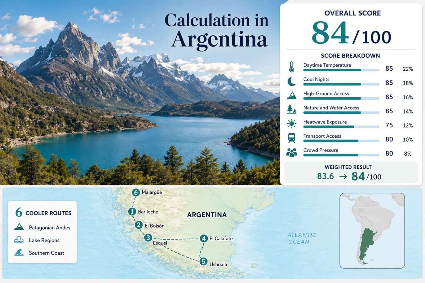
Argentina Coolcation Routes: Patagonia, High Andes and Lakeside Summer Air
Argentina’s January–February cool-air range stretches from the forested shores of Nahuel Huapi and Lago Puelo to the glacier-fed water of Lago Argentino, the Beagle Channel and the 1,429-metre base of Malargüe. The strongest heat relief lies in southern Patagonia, while the High Andes provide altitude and dry nights with a greater chance of hot afternoons.
The same six bases appear in the map, score, route cards and comparison table.
Argentina’s core Southern Hemisphere holiday period and the scoring window used for temperature comparisons.
Median of the six representative station averages for January and February daily maximum temperature.
Cool nights are widespread, although Ushuaia requires a transparent minimum-temperature proxy because its cited normal table is incomplete.
Its January and February average daily maximum is 13.6°C at the official airport station.
High-Andes access is immediate, but afternoon heat exposure is materially higher than in far-southern Patagonia.
From Nahuel Huapi to the Beagle Channel
The six planning bases span more than 19 degrees of latitude and three distinct cooling systems: Andean altitude, Patagonian forest-and-lake air, and the cold maritime influence of the far south.
This marker map is built for planning orientation. Marker positions use approximate public location centres where exact viewpoints, trailheads, legal parking areas or pull-offs are not specified. Use each route card for Google Maps links and access notes before travelling.
Argentina Patagonia and Andes Cooler Escape Suitability Score
A transparent editorial suitability index based on disclosed climate, landscape, access and pressure factors. It is not an official climate classification or a weather forecast.
Method: Median January–February average daily maximum across the six representative stations, normalized with the fixed daytime-temperature scale.
Raw: Route median 22.65°C; linear interpolation between 21°C = 100 and 23°C = 90 gives 91.75, rounded to 92.
Route values: Bariloche 23.15°C; El Bolsón 25.70°C; Esquel 22.15°C; El Calafate 19.15°C; Ushuaia 13.60°C; Malargüe 28.15°C. Median: 22.65°C.
Source mapping: Bariloche Aero WIGOS 0-20000-0-87765, direct city-airport station at 835 m; El Bolsón Aero 0-20000-0-87800, direct local station at 337 m; Esquel Aero 0-20000-0-87803, representative city-airport station at 799 m; El Calafate Aero 0-20000-0-87904, representative city-airport station at 199 m; Ushuaia Aero 0-20000-0-87938, direct city-airport station at 57 m; Malargüe Aero 0-20000-0-87506, direct local station at 1,429 m.
Period: 1991–2020 for Bariloche, Esquel and Malargüe; 1995–2020 for El Bolsón; 2001–2020 for El Calafate; 1997–2020 for Ushuaia.
Sources: Servicio Meteorológico Nacional, Estadísticas climatológicas normales 1991–2020.
Method: Median January–February average daily minimum across the route stations. Ushuaia’s cited table does not publish complete January–February minimum normals, so a transparent temperature-balance proxy was used only for that route: two times mean temperature minus average maximum temperature.
Raw: Route median 7.40°C; interpolation between 6°C = 60 and 8°C = 85 gives 77.5, rounded to 78.
Route values: Bariloche 6.80°C; El Bolsón 7.80°C; Esquel 8.35°C; El Calafate 7.00°C; Ushuaia 5.30°C proxy; Malargüe 11.15°C. Median: 7.40°C.
Source mapping: The same stations and WIGOS identifiers used for daytime temperature. Ushuaia proxy inputs are January–February mean temperatures of 9.5°C and 9.4°C and average maxima of 13.6°C in both months.
Period: Same station periods as the daytime factor; Ushuaia proxy uses its published 1997–2020 mean and maximum tables.
Sources: Servicio Meteorológico Nacional station normal tables.
Method: Fixed access rubric based on accommodation-base elevation or regular access to higher terrain within approximately 60 minutes.
Raw: Median route score 80/100.
Route scores: Bariloche 80 — 835 m station base and nearby Andean roads; El Bolsón 60 — 337 m base with meaningful nearby mountain access; Esquel 80 — 799 m base and immediate foothill access; El Calafate 60 — low 199 m base but regular access to elevated glacial terrain; Ushuaia 100 — low city base but rapid access to the Martial range and a 900 m ascent in Tierra del Fuego National Park; Malargüe 100 — 1,429 m base with direct High-Andes access. Median: 80/100.
Period: Access conditions reviewed 15 July 2026; station elevations use the published climate-normal metadata.
Sources: SMN station elevations; Tierra del Fuego trail elevations; Paso Pehuenche official status page.
Method: Fixed physical-access rubric measuring whether broad forest, a major lake or river system, or sea coast is reachable within 30 minutes of the route base.
Raw: Median route score 100/100.
Route scores: Bariloche 100 — Nahuel Huapi plus Andean forest; El Bolsón 100 — Patagonian forest plus Lago Puelo and connected river systems; Esquel 100 — Los Alerces forest and linked lakes; El Calafate 75 — direct Lago Argentino access; Ushuaia 100 — Beagle Channel coast plus subantarctic forest; Malargüe 45 — water and mountain landscapes require a longer drive and forest access is weak. Median: 100/100.
Period: Public-access conditions reviewed 15 July 2026.
Sources: Nahuel Huapi access; Lago Puelo landscape; Los Alerces access; Los Glaciares landscape; Tierra del Fuego forest-and-coast setting.
Method: Official threshold-risk proxy using SMN January–February normal maxima, published daily extreme maxima and the national daily-extremes data catalogue. A uniform 10-summer daily extraction was not reconstructed, so no exact 30°C-day percentages are claimed.
Raw: Median route proxy score 90/100 on the fixed heatwave scale; the factor is retained with comparability class C rather than presenting unsupported daily counts.
Route scores: Bariloche 90 — cool normal maxima but recorded daily maxima above 30°C; El Bolsón 75 — warmer valley exposure; Esquel 90 — cool normal maxima with occasional threshold exceedance; El Calafate 100 — January–February normal maxima near 19°C; Ushuaia 100 — published 1997–2020 daily extreme maximum remains below 30°C; Malargüe 55 — January average maximum 29.1°C and substantially greater threshold risk. Median: 90/100.
Period: Station climate periods as published in the SMN normal tables; official daily-extremes catalogue reviewed 15 July 2026.
Sources: SMN climate normals and daily extreme records; SMN daily extreme-temperature data catalogue.
Method: Fixed transport rubric covering direct air or intercity-bus arrival, local public or scheduled visitor transport, connection complexity and practical car dependence.
Raw: Median route score 90/100.
Route scores: Bariloche 100 — major airport, intercity coaches and extensive visitor transport; El Bolsón 80 — regular coach access but greater local car dependence; Esquel 80 — airport and coaches, with a daily park bus but reduced frequency outside high season; El Calafate 100 — airport and regular scheduled excursion transport; Ushuaia 100 — airport, urban base and scheduled park or channel services; Malargüe 60 — road access is straightforward but High-Andes sites remain car-dependent and the border road is weather-sensitive. Median: 90/100.
Period: Current access framework reviewed 15 July 2026.
Sources: Nahuel Huapi transport access; Esquel–Los Alerces access; Tierra del Fuego access; Malargüe airport listing; Vialidad Nacional route-status service.
Method: Official occupancy evidence mapped to the fixed crowd rubric. Destination years differ, so the result measures demonstrated peak pressure rather than a single-year national comparison.
Raw: Median route score 0/100. Bariloche and El Bolsón were reported near 80% occupancy in summer 2025; official peak reports for the other routes show 90% or higher occupancy during major January periods.
Route scores: Bariloche 20 — 80–83% in early summer 2025; El Bolsón 20 — about 80% in the same 2025 report; Esquel 0 — 95% in the second half of January 2022; El Calafate 0 — 91% in that period; Ushuaia 0 — 90% in that period; Malargüe 0 — full occupancy reported around the Fiesta Nacional del Chivo in January 2020. Median: 0/100.
Period: January 2020, January 2022 and summer 2025 official reports; latest route-specific comparable evidence was not uniform across all six bases.
Sources: Argentina tourism, summer 2025 occupancy; Argentina tourism, January 2022 Patagonia occupancy; Argentina tourism, January 2020 Malargüe pressure; INDEC hotel occupancy survey, January 2025.
Lakes, Glaciers, Forest Towns and High-Andes Bases
Each card uses the station and access evidence applied in the score. The temperatures are climate normals, not a forecast for a particular trip.
Bariloche and Nahuel Huapi
January–February climate: Average daily maxima of 23.2°C and 23.1°C; average minima of 7.0°C and 6.6°C at Bariloche Aero. The lake moderates the setting, but short hot spells can still lift afternoons above the normal range.
Nahuel Huapi works for travellers who want a full-service city without giving up rapid access to water, forest and high roads. The trade-off is logistics: Cerro Tronador, Cascada Los Alerces and Lago Steffen use controlled or one-way road windows, so a late start can block the intended circuit.
Open Bariloche and Nahuel Huapi in Google Maps · Official park access
El Bolsón and Lago Puelo
El Bolsón is warmer by day than Bariloche or Esquel: both January and February average daily maxima are 25.7°C, while average minima are 7.9°C and 7.7°C. That wide day–night range rewards early walks, shaded midday plans and evenings outdoors.
Lago Puelo adds a large water body and dense Patagonian forest to the valley itinerary. The national park is reached by paved RP 16 and lists daily opening from 09:00 to 19:00. January demand can be intense; an official 2025 summer report placed El Bolsón near 80% occupancy.
Open El Bolsón and Lago Puelo in Google Maps · Official park access
Esquel and Los Alerces
Esquel combines a high town base with cooler afternoons: January and February average daily maxima are 22.0°C and 22.3°C, and minima are 8.6°C and 8.1°C. Los Alerces then adds linked lakes, old-growth forest and long daylight for a full-day circuit.
The park’s central gateway is 38 km from Esquel, while Villa Futalaufquen is 52 km away. Summer access at Portada Sur runs from 09:00 to 20:00, and the visitor centre operates 08:00 to 19:00 from November to Easter. A daily bus links Esquel with park points, although frequency is lower outside high season.
Open Esquel and Los Alerces in Google Maps · Official park access
El Calafate and Lago Argentino
El Calafate’s January and February average daily maxima are 19.1°C and 19.2°C, with minima of 7.2°C and 6.8°C. Lago Argentino and the Southern Patagonian Ice Field keep the broader route cool, but exposed viewpoints can feel much colder in wind than the station temperature implies.
The Mitre–Perito Moreno Glacier corridor operates in summer from 08:00 to 18:00, with permitted stay until 20:00, from 1 September through 30 April. The airport and organised transfers make the route relatively car-light, while independent side trips become more vehicle-dependent.
Open El Calafate and Lago Argentino in Google Maps · Official Los Glaciares access
Ushuaia and Beagle Channel
Ushuaia is the lowest-heat base in the route set. January and February average daily maxima are both 13.6°C; mean temperatures are 9.5°C and 9.4°C. The cited 1997–2020 table records a daily maximum of 28.5°C, below the 30°C heatwave threshold used in the score.
Tierra del Fuego National Park opens daily from 08:00 to 20:00. RN 3 continues through the park to Bahía Lapataia, where forest, peatland, lake and coast sit within one compact road system. The official speed limit is 40 km/h because wildlife frequently crosses the road.
Open Ushuaia and Beagle Channel in Google Maps · Official park access
Malargüe and the High Andes
Malargüe supplies altitude rather than low-latitude maritime cooling. January and February average daily maxima are 29.1°C and 27.2°C, while minima are 11.6°C and 10.7°C. Nights sit in the scoring system’s ideal band, but midday plans need more heat discipline than in Patagonia.
The base opens access to RN 145 and Paso Pehuenche, volcanic country and La Payunia. The reserve lies about 120 km southeast of town, is normally approached between October and May, and requires entry with a guide. High-road status can change rapidly with snow, whiteout conditions or strong wind.
Open Malargüe and the High Andes in Google Maps · Official Paso Pehuenche status · Official La Payunia planning note
Route 40 Connects the Bases, Not Their Summer Climate
A north–south itinerary can move from dry High-Andes heat to temperate lake valleys and then into cold maritime Patagonia without leaving Argentina’s western corridor.
Malargüe: Altitude With Hotter Afternoons
The 1,429-metre station base delivers average January–February minima near 11°C, yet the daytime average reaches 28.2°C. Elevation helps after sunset; it does not erase strong continental solar heating.
Bariloche to Esquel: Forest, Lakes and Larger Day–Night Swings
Bariloche, El Bolsón and Esquel combine 337–835 m bases with large lakes and Andean forest. Daytime normals range from about 22°C to 26°C, while route nights cluster around 7–8°C.
El Calafate and Ushuaia: Wind, Ice and Maritime Cooling
El Calafate remains near 19°C by day; Ushuaia falls to 13.6°C. The far south offers the strongest heat buffer, but wind and rapidly shifting cloud can make outdoor comfort less predictable.
North Patagonian Fire Rules Can Override a Lakeside Plan
Dry spells can change what is legal at campsites and picnic areas even when lake temperatures remain mild. The National Parks Administration prohibited fire in Nahuel Huapi, Los Arrayanes, Lago Puelo, Los Alerces and Lanín through 30 April 2026, allowing only secure fire installations operated by authorised tourism providers.
Check the Current Park Notice
The 2025–26 restriction has ended, but it demonstrates that a full summer can fall under a regional ban. Verify the active notice for the travel year rather than assuming a designated campsite permits a stove or open flame.
Carry a No-Flame Meal Plan
A lakeside day remains viable when fire use is suspended if food, water and shelter do not depend on cooking. This matters most on long RP 71 and Nahuel Huapi circuits with limited late-day services.
Treat Wind as a Fire Variable
Patagonian wind can transport sparks into dry forest and grass. The official system uses a fire-weather index, so restrictions may tighten even when the air temperature itself feels cool.
Nahuel Huapi’s One-Way Roads Set the Daily Clock
Several classic lake-and-mountain branches west and south of Bariloche are not flexible out-and-back drives. Their directional windows determine when a route can enter, turn around and return.
Cerro Tronador and Pampa Linda
About 50 km of gravel road runs from Los Rápidos toward Pampa Linda. Official windows list entry from 10:30 to 14:00, exit from 16:00 to 18:00 and two-way movement from 19:30 to 09:00.
Cascada Los Alerces
Inbound one-way traffic runs from 14:00 to 17:00; outbound one-way traffic runs from 11:00 to 13:00; two-way movement is listed from 18:00 to 10:00.
Lago Steffen and El Manso
Entry is listed from 10:00 to 14:00 and exit from 15:00 to 20:00. Missing the outbound period can turn a short lake plan into an unintended long wait.
Planning rule: Treat the official road notice as a timetable, not a suggestion. Conditions can change, particularly after rain, wind or maintenance work. Review current Nahuel Huapi access windows.
Six Bases Compared by Heat, Elevation and Access
The table keeps the route set identical to the map and score. Temperature values are the January–February means used in the score, rounded to one decimal.
| Route base | Average daily maximum | Average daily minimum | Station elevation | Primary cooling system | Planning trade-off |
|---|---|---|---|---|---|
| Bariloche and Nahuel Huapi | 23.2°C | 6.8°C | 835 m | Large lake, forest and Andean access | One-way park roads and high January demand |
| El Bolsón and Lago Puelo | 25.7°C | 7.8°C | 337 m | Forested valley, lake and cool nights | Warmest lake-belt afternoons and booking pressure |
| Esquel and Los Alerces | 22.2°C | 8.4°C | 799 m | High town plus linked forest lakes | Long park corridor and gate-time discipline |
| El Calafate and Lago Argentino | 19.2°C | 7.0°C | 199 m | Glacier-fed lake and ice-field air | Wind exposure and premium peak-season capacity |
| Ushuaia and Beagle Channel | 13.6°C | 5.3°C proxy | 57 m | Cold coast, subantarctic forest and nearby peaks | Rain, wind and rapid cloud changes |
| Malargüe and the High Andes | 28.2°C | 11.2°C | 1,429 m | Altitude, dry air and high-road access | Hotter afternoons and strong car dependence |
December, Peak Summer and March Serve Different Plans
December: Long Light Before Peak Capacity
Roads and park services are generally in summer mode, daylight is long and the most intense January booking pressure has not fully arrived. Water remains cool, especially in the far south.
January–February: Full Access, Full Pressure
This is the score window and the broadest period for park transport, lake circuits and high-road travel. It is also the period most likely to combine sold-out accommodation, parking pressure and fire restrictions in northern Patagonia.
March: Lower Demand With Shorter Days
March often improves booking flexibility while retaining access to many Patagonian routes. Nights cool further, daylight contracts and some seasonal transport begins reducing frequency.
Route choice by heat: Ushuaia and El Calafate provide the lowest daytime exposure; Esquel offers a balanced high-town and lake-park combination; Bariloche provides the strongest car-light service base; Malargüe is the altitude choice when dry nights matter more than cool afternoons.