Chile for Southern Cooldowns: Patagonia, Lake Districts and Andes Towns
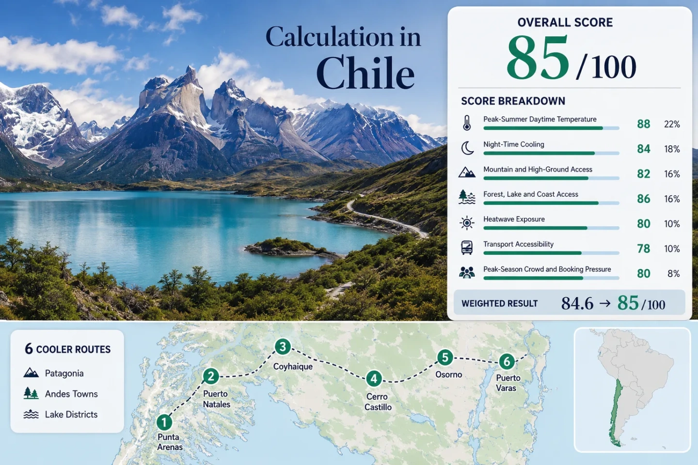
Chile’s southern summer routes are not one climate zone. The Strait of Magellan delivers low daytime temperatures and persistent wind, Aysén adds cold nights and high-road access, while the Lake District pairs milder shorelines with warmer inland afternoons. The strongest January–February plan uses that north–south contrast deliberately: maritime Patagonia for the lowest heat, Coyhaique and Cerro Castillo for night cooling, and Llanquihue or Puyehue for easier lake-and-forest access.
The set runs from Punta Arenas and Puerto Natales north through Aysén to Osorno and Lago Llanquihue.
Its 1991–2020 January–February normal daytime maximum is about 15.1°C, with wind as the main comfort trade-off.
The Balmaceda representative station averages roughly 6.5°C for January–February minimum temperature.
Puerto Varas, Osorno–Puyehue, Coyhaique and Cerro Castillo place substantial water or forest systems close to the overnight base.
Recent official February surveys placed Torres del Paine, Coyhaique–Aysén and Lago Llanquihue among Chile’s high-occupancy destinations.
Patagonian air links shorten the first leg, but Ruta 9 and Carretera Austral segments still require weather-aware transfer planning.
From the Strait of Magellan to the Lake District
The six markers follow a practical southern-cooling sequence rather than a single continuous drive. Magallanes, Aysén and Los Lagos are separated by long distances, fjords and air-transfer decisions, so each marker works as a regional planning center.
Markers show selected cooler-route regions and approximate public location centers, not guaranteed legal parking, trailheads or exact viewpoints. Use the route cards for Google Maps searches and verify park access before traveling.
Chile Southern Cooler Escape Suitability Score
This transparent editorial suitability index uses disclosed climate, landscape, access and pressure factors. It is not an official climate classification or a weather forecast. Every route carries equal weight, and route count creates no score bonus.
Method: Mean of the January and February 1991–2020 normal daily maxima for each direct or representative DMC station, followed by the six-route median.
Route values: Punta Arenas 15.1°C; Puerto Natales and Torres del Paine 15.1°C using Punta Arenas as a conservative Magallanes representative; Coyhaique 19.8°C; Villa Cerro Castillo 18.7°C using Balmaceda; Osorno and Puyehue 23.0°C; Puerto Varas and Lago Llanquihue 20.0°C using Puerto Montt–El Tepual.
Raw: Route median 19.25°C. The fixed scale assigns 100 at 21°C or lower.
Period: January–February climate normals, 1991–2020.
Sources: Dirección Meteorológica de Chile January normal table, February normal table, and station metadata for Punta Arenas, Coyhaique, Balmaceda and Puerto Montt–El Tepual.
Method: Mean January–February normal daily minimum at the same station set, then the route median. The measure rewards useful overnight relief rather than the coldest possible night.
Route values: Punta Arenas 6.8°C; Puerto Natales and Torres del Paine 6.8°C representative value; Coyhaique 8.7°C; Villa Cerro Castillo 6.5°C using Balmaceda; Osorno and Puyehue 8.6°C; Puerto Varas and Lago Llanquihue 9.1°C using Puerto Montt–El Tepual.
Raw: Route median 7.7°C. Linear interpolation between 6°C = 60 and 8°C = 85 produces 81.25, shown as 81/100.
Period: January–February climate normals, 1991–2020.
Sources: The same DMC January and February normal tables and the linked station metadata above.
Method: Fixed categorical rubric based on overnight-base elevation or regular access to meaningful high ground within roughly 60 minutes.
Route scores: Punta Arenas 30 — nearby reserve hills but limited elevation gain; Puerto Natales and Torres del Paine 80 — regular access to major mountain terrain; Coyhaique 80 — mountain and reserve access around the city; Villa Cerro Castillo 100 — Andes base with immediate high terrain; Osorno and Puyehue 80 — established access toward Puyehue’s mountain zone; Puerto Varas and Lago Llanquihue 80 — regular access toward Osorno volcano and Vicente Pérez Rosales.
Raw: Median 80/100.
Period: Access conditions reviewed July 15, 2026.
Sources: CONAF information for Torres del Paine and Vicente Pérez Rosales, plus the official Pases Parques portal for current protected-area entry systems.
Method: Fixed physical-access rubric. A score of 100 requires at least two strong elements—large forest, major lake or river system, or sea coast—within about 30 minutes.
Route scores: Punta Arenas 100 — Strait coast plus Magallanes forest; Puerto Natales and Torres del Paine 100 — fjord shore plus mountain-forest systems; Coyhaique 75 — strong forest and river access; Villa Cerro Castillo 75 — forested valley and river access; Osorno and Puyehue 100 — lakes plus temperate forest; Puerto Varas and Lago Llanquihue 100 — major lake plus forest-and-river access toward the Andes.
Raw: Median 100/100.
Period: Physical access reviewed July 15, 2026.
Sources: CONAF protected-area pages, the official park entry portal, and DMC station metadata documenting the regional terrain context.
Method: Official threshold-frequency fallback. DMC’s annual count of days above 30°C was averaged over 2015–2024 and divided by the 61 days in January–February. Counting the full annual total inside the target window creates a conservative upper-bound proxy because a common daily January–February extraction was not available in the cited product.
Route values: Punta Arenas 0.0%; Puerto Natales and Torres del Paine 0.0% using Punta Arenas; Coyhaique 5.1%; Villa Cerro Castillo 5.1% using Coyhaique; Osorno and Puyehue 6.9%; Puerto Varas and Lago Llanquihue 6.9% using Osorno as the warmer regional threshold proxy.
Raw: Median 5.1%. Linear interpolation between 5% = 75 and 10% = 55 produces 74.6, shown as 75/100.
Period: Ten completed calendar years, 2015–2024; annual 30°C threshold counts used as a conservative January–February proxy.
Sources: DMC climate-index tables for Punta Arenas, Coyhaique and Osorno; DMC heat-event methodology.
Method: Fixed transport rubric measuring whether a visitor can reach the overnight base and primary cooling landscape without a complex private-vehicle chain.
Route scores: Punta Arenas 100 — airport and urban base; Puerto Natales and Torres del Paine 80 — air or intercity-bus access to town, then scheduled park transfer; Coyhaique 80 — Balmaceda air gateway and ground transfer; Villa Cerro Castillo 40 — limited services and strong car advantage; Osorno and Puyehue 80 — accessible city base with onward road transfer; Puerto Varas and Lago Llanquihue 100 — frequent access through the Puerto Montt transport system and a workable car-light town stay.
Raw: Median 80/100.
Period: Network structure reviewed July 15, 2026; timetables remain date-sensitive.
Sources: Dirección General de Aeronáutica Civil airport information, official CONAF park pages and SERNATUR’s tourism data portal.
Method: Official February lodging occupancy where a matching destination zone was published; categorical capacity evidence where a route lacked a directly comparable percentage.
Route scores: Punta Arenas 20 — 82.2% for Punta Arenas–Estrecho in February 2024; Puerto Natales and Torres del Paine 20 — 85.2% for Torres del Paine–Puerto Natales in February 2024; Coyhaique 20 — 80.6% in 2024 and 84.8% in 2025 destination reporting; Villa Cerro Castillo 40 — smaller base within a high-demand Aysén corridor; Osorno and Puyehue 60 — regular summer demand without the same published destination-zone peak; Puerto Varas and Lago Llanquihue 20 — 83.5% for Lago Llanquihue–Todos los Santos in February 2024.
Raw: Median 20/100.
Period: Latest directly comparable official destination surveys used: February 2024 and February 2025.
Sources: SERNATUR February 2024 occupancy release and February 2025 occupancy release.
Weighted formula: 100×0.25 + 81×0.20 + 80×0.15 + 100×0.15 + 75×0.10 + 80×0.10 + 20×0.05
Weighted result: 84.7 → 85/100
Patagonia, Lake Shores and Andes Bases
The route set separates cold maritime bases from easier northern lake towns. Figures are historical normals or disclosed representative-station values.
Punta Arenas and Reserva Nacional Magallanes
The city faces the Strait of Magellan, while forested reserve roads rise west of the urban area. Its low summer maximum is the clearest daytime-cooling signal. Main caution: Wind can restrict exposed walking, driving and boat schedules.
Airport access and city services support a car-light base; a vehicle or organized transfer improves reserve and outer-coast reach.
Punta Arenas and Reserva Nacional Magallanes on Google MapsPuerto Natales and Torres del Paine
Puerto Natales supplies lodging and transport on the Última Esperanza fjord; Torres del Paine supplies the high-ground range. Punta Arenas normals act as a conservative Magallanes representative, not an identical local climate.
Watch for: Park entry requirements, scheduled transfers and accommodation pressure during the January–February peak.
Puerto Natales and Torres del Paine on Google MapsCoyhaique and Reserva Nacional Coyhaique
Coyhaique is the most service-complete Aysén base. Its direct DMC station strengthens the comparison, while nearby reserve, river and mountain access preserves the cooling logic.
The airport is at Balmaceda rather than in the city; transfer time should be included before linking onward Carretera Austral segments.
Coyhaique and Reserva Nacional Coyhaique on Google MapsVilla Cerro Castillo and the Ibáñez Valley
The village sits beneath the Cerro Castillo massif on Ruta 7. Balmaceda, roughly 55 kilometers northeast, supplies the representative normal. Cold nights come with thinner public transport than Coyhaique.
Works for: Travelers prioritizing cold nights and mountain access over urban services.
Villa Cerro Castillo and the Ibáñez Valley on Google MapsOsorno and Puyehue
Osorno is warmer by day than Patagonia, but it is a practical hub for Puyehue’s lakes, forest and Andes road. It suits travelers valuing services and water access over the lowest afternoon temperature.
A car or organized transfer substantially improves access beyond the city, especially for dispersed lakeside and park locations.
Osorno and Puyehue on Google MapsPuerto Varas and Lago Llanquihue
Puerto Varas combines a walkable lakeside center with access toward Ensenada, Petrohué and Vicente Pérez Rosales. Puerto Montt–El Tepual is the representative station. Shore breezes help, while cloud, rain and visibility shift quickly.
Good for: A softer logistics profile with lake access, restaurants and frequent regional connections.
Puerto Varas and Lago Llanquihue on Google MapsMagallanes Trades Heat for Wind and Transfer Dependence
Punta Arenas Works as the Low-Heat City Base
January–February normal maxima near 15°C place Punta Arenas below the Lake District routes. The Strait-facing position keeps maritime air in the daily pattern. The trade-off is operational rather than thermal: wind can limit coastal walks, reserve roads and marine excursions.
Puerto Natales Adds a Capacity Layer
Puerto Natales is the service gateway for timed transfers, park entry systems and peak lodging demand. February 2024 occupancy for Torres del Paine–Puerto Natales reached 85.2%, making early accommodation and transport decisions important.
Balmaceda Nights Separate Cerro Castillo from the Lake District
Aysén and Los Lagos separate most clearly after sunset: about 6.5°C for the Cerro Castillo proxy versus 9.1°C for Puerto Varas.
Coyhaique Balances Services and Cold Air
Coyhaique retains an 8.7°C normal minimum while supplying supermarkets, medical services, ground transfers and a direct climate station. It is the more resilient base when weather disrupts an Aysén day plan.
Cerro Castillo Pushes Closer to the Andes
Villa Cerro Castillo gives up service depth for immediate mountain geography. Nights are colder, trail access is more direct and public transport is thinner. A vehicle changes the route from a fixed village stay into a flexible valley plan.
Llanquihue Offers a Milder Landing
Puerto Varas has warmer nights, easier dining and a more forgiving transport network. That makes it a stronger arrival or departure base, but not the route for travelers seeking Patagonia’s deepest overnight cooling.
Six Routes by Temperature, Access and Pressure
The same six routes used by the map and score appear here. Climate figures are January–February 1991–2020 means from direct or disclosed representative stations.
| Route | Max / min | High-ground access | Car-light strength | Peak pressure | Main weather trade-off |
|---|---|---|---|---|---|
| Punta Arenas and Reserva Nacional Magallanes | 15.1°C / 6.8°C | Limited-to-moderate hills | Strong in the city | High destination occupancy | Persistent wind and exposed coast |
| Puerto Natales and Torres del Paine | 15.1°C / 6.8°C representative | Major mountain terrain by transfer | Moderate with scheduled services | Very high lodging and park demand | Wind, transfer timing and capacity |
| Coyhaique and Reserva Nacional Coyhaique | 19.8°C / 8.7°C | Strong nearby mountain access | Moderate after airport transfer | High regional occupancy | Fast weather changes between valleys |
| Villa Cerro Castillo and the Ibáñez Valley | 18.7°C / 6.5°C representative | Immediate Andes access | Weak | Moderate, with small-base capacity | Cold nights and limited backup services |
| Osorno and Puyehue | 23.0°C / 8.6°C | Strong by road transfer | Moderate | Moderate | Warmer inland afternoons |
| Puerto Varas and Lago Llanquihue | 20.0°C / 9.1°C representative | Strong toward the Andes | Strong in town | High lake-zone occupancy | Rain, cloud and variable visibility |
Three Live Checks Before a Southern Chile Transfer
Weather: Review the latest DMC forecast for wind as well as temperature; a mild Patagonian day can still be unsuitable for exposed road, trail or marine plans. Protected areas: Confirm opening status, entry requirements and capacity through CONAF and Pases Parques. Road sequence: Recheck Ruta 9 and Carretera Austral timing before connecting Magallanes, Aysén and Los Lagos, because these regions should not be treated as short neighboring stops.