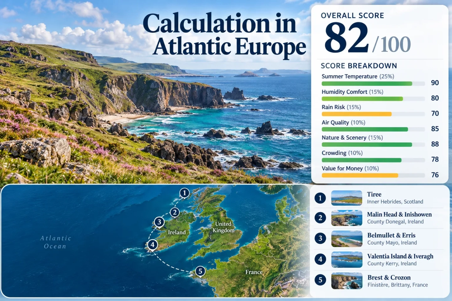
From Tiree in the Inner Hebrides to the Crozon Peninsula in Brittany, Europe’s Atlantic edge offers summer bases shaped more by maritime air than continental heat. The five-route set here keeps July–August station normals low, but the trade is real: wind, frequent rain, ferry dependence and uneven public transport can matter as much as the temperature.
Routes Assessed
5 Atlantic route groups
One Scottish island, three Irish Atlantic bases and one western Brittany route group form the same set used in the map, score and comparison.
Target Window
July–August
The score uses the Northern Hemisphere peak-summer window rather than shoulder-season temperatures.
Daytime Normal Range
16.4–20.9°C
Range of the five representative July–August mean daily maxima from official 1991–2020 station normals.
Rain Trade-Off
Atlantic exposure
Tiree and Malin Head average roughly 14–16 days per month with at least 1 mm of rain in July or August; western Ireland also carries high monthly rainfall totals.
Car-Light Anchor
Brest & Crozon
Brest has direct long-distance rail, while summer and regional coach links reach the Crozon Peninsula; the outer peninsula still needs timetable-aware planning.
Tiree to Finistère Planning Markers
The route set follows exposed Atlantic islands, headlands and peninsulas rather than inland cities. Marker positions are practical public centers for orientation.
This marker map is for planning orientation. Marker positions use approximate public location centers where exact viewpoints, trailheads, legal parking areas or pull-offs are not specified. Use each route card for Google Maps links and current access checks before traveling.
Atlantic Edge Cooler Escape Suitability Score
This is a transparent editorial suitability index based on disclosed climate, landscape, access and pressure factors. It is not an official climate classification or a weather forecast.
82out of 100
Calculated from 7 disclosed factors
Target windowJuly–August
Climate baseline1991–2020 for temperature normals
Heatwave periodMixed official threshold periods
Routes assessed5 routes
MethodologyVersion 1.2
Last reviewedOctober 8, 2026
Factor coverage7/7
Comparability qualityB — official data with mixed threshold periods and categorical access evidence
Peak-Summer Daytime Temperature25%
100/100
Method: Official station-normal aggregation using the July–August mean of mean daily maximum temperature for each route.Raw: Route median 17.7°C.Route values: Tiree 16.4°C; Malin Head & Inishowen 17.1°C; Belmullet & Erris 17.7°C; Valentia Island & Iveragh 17.9°C; Brest & Crozon 20.9°C. Median: 17.7°C.Source mapping: Tiree — direct Met Office station, station code not published on the cited page; Malin Head — direct Met Éireann station, code not published on the cited table; Belmullet — direct Met Éireann station, code not published on the cited table; Valentia route — nearby Valentia Observatory, representative of the Iveragh coast, code not published on the cited table; Brest & Crozon — Brest-Guipavas, code 29075001, 92 m, representative of western Finistère.Period: 1991–2020.Sources:Met Office Tiree normals; Met Éireann Malin Head normals; Met Éireann Belmullet normals; Met Éireann Valentia normals; Météo-France Brest-Guipavas sheet.
Method: Official station-normal aggregation using the July–August mean of mean daily minimum temperature for each route.Raw: Route median 12.4°C.Route values: Tiree 11.4°C; Malin Head & Inishowen 12.3°C; Belmullet & Erris 12.4°C; Valentia Island & Iveragh 12.9°C; Brest & Crozon 13.2°C. Median: 12.4°C.Source mapping: The same official station mappings used for daytime temperature are retained so daytime and night-time medians describe the same five-route set.Period: 1991–2020.Sources:Met Office Tiree normals; Met Éireann Malin Head normals; Met Éireann Belmullet normals; Met Éireann Valentia normals; Météo-France Brest-Guipavas sheet.
Method: Fixed categorical rubric based on the accommodation base and whether meaningful higher ground is integrated into a practical route day.Raw: Median categorical route score 30/100.Route scores: Tiree 0 — low, flat island base; Malin Head & Inishowen 30 — higher Inishowen terrain requires a deliberate detour from the headland base; Belmullet & Erris 30 — low Mullet Peninsula base with higher terrain farther inland; Valentia Island & Iveragh 60 — meaningful Iveragh uplands can be reached on a route day; Brest & Crozon 60 — Menez-Hom reaches 330 m at the Crozon gateway. Median: 30/100.Route rationale: The Atlantic-edge set is primarily a maritime-cooling portfolio, not a high-altitude portfolio.Period: Access and topographic review current to October 8, 2026.Sources:Ordnance Survey maps; Tailte Éireann GeoHive; Parc naturel régional d’Armorique: Menez-Hom.
Forest, Lake and Coast Access15%
75/100
Method: Fixed physical-access rubric for sea coast, large water systems and substantial forest within practical reach.Raw: Median categorical route score 75/100.Route scores: Tiree 75 — immediate Atlantic coast; Malin Head & Inishowen 75 — immediate Atlantic coast; Belmullet & Erris 100 — Atlantic coast plus nearby Carrowmore Lake system; Valentia Island & Iveragh 75 — immediate marine access; Brest & Crozon 100 — Iroise/Brest maritime access plus wooded Armorique sectors. Median: 75/100.Route rationale: Coast access is the common cooling asset; the factor measures physical access rather than scenic quality.Period: Access review current to October 8, 2026.Sources:Ordnance Survey maps; Tailte Éireann GeoHive; Parc d’Armorique ecological network.
Heatwave Exposure10%
100/100
Method: Official threshold-frequency fallback. Where official July–August absolute maxima remain below 30°C, the published record implies no 30°C threshold day in that stated record period; Brest-Guipavas publishes mean monthly counts for Tx ≥ 30°C directly.Raw: Median route exposure 0.0% of July–August days at or above 30°C under the cited official fallback periods.Route values: Tiree 0.0% — July/August recorded extremes 26.3/25.0°C for 1927–2014; Malin Head & Inishowen 0.0% — 1991–2020 absolute maxima 25.9/25.9°C; Belmullet & Erris 0.0% — 29.9/27.7°C; Valentia Island & Iveragh 0.0% — 27.6/28.0°C; Brest & Crozon 1.0% — 0.4 July plus 0.2 August days on average with Tx ≥ 30°C, equal to about 0.6/62 days. Median: 0.0%.Source mapping: Tiree uses the Met Office Western Scotland station-extremes publication; Irish routes use Met Éireann 1991–2020 absolute maxima; Brest-Guipavas uses the Météo-France published threshold-frequency table.Period: Tiree extremes 1927–2014; Irish station normals 1991–2020; Brest-Guipavas 1991–2020 threshold frequency.Sources:Met Office Western Scotland climate; Met Éireann Malin Head; Met Éireann Belmullet; Met Éireann Valentia; Météo-France Brest-Guipavas.
Transport Accessibility10%
80/100
Method: Fixed categorical rubric using current scheduled rail, coach, local bus and ferry access.Raw: Median categorical route score 80/100.Route scores: Tiree 20 — ferry-dependent island access and limited local network; Malin Head & Inishowen 80 — route 954 links Malin Head and Carndonagh with onward connections; Belmullet & Erris 80 — route 460b runs Béal an Mhuirthead–Castlebar seven days with a listed 1 h 35 min journey; Valentia Island & Iveragh 40 — route 287a serves the island only Tuesday, Thursday and Friday, while 287c links Portmagee and Cahersiveen Monday–Saturday; Brest & Crozon 100 — direct Paris–Brest rail plus line 934 into Crozon/Camaret. Median: 80/100.Route rationale: The score reflects reaching and using the route without assuming a rental car is always available.Period: Timetables checked October 8, 2026; seasonal services can change.Sources:CalMac Oban–Coll–Tiree; TFI Local Link route 954; TFI Local Link Mayo timetable; Local Link Kerry Valentia; SNCF Paris–Brest; Finistère line 934.
Peak-Season Crowd and Booking Pressure5%
60/100
Method: Fixed categorical capacity rubric using ferry dependence, official visitor-management work, reservation signals and summer parking or shuttle constraints where comparable occupancy data are not available across all five routes.Raw: Median categorical route score 60/100.Route scores: Tiree 60 — summer ferry booking makes transport capacity part of trip planning; Malin Head & Inishowen 60 — official visitor-management work includes added parking and traffic arrangements; Belmullet & Erris 80 — the official Wild Mayo plan spreads activity across a broad North Mayo area without a route-wide reservation system; Valentia Island & Iveragh 40 — optional Sceilg Mhichíl visits require advance booking and remain weather/sea dependent; Brest & Crozon 60 — Crozon authorities document summer parking pressure and operate limited-capacity summer shuttles. Median: 60/100.Route rationale: These are capacity and planning signals, not a claim that every settlement reaches the same occupancy level.Period: Latest official planning and access material reviewed through October 8, 2026.Sources:CalMac Tiree route information; Donegal County Council Inishowen meeting report; Fáilte Ireland Wild Mayo plan; OPW Sceilg Mhichíl 2026 access notice; Crozon summer shuttle information.
The five bases are not interchangeable. Tiree puts the strongest maritime cooling first; Malin Head and Erris pair mild afternoons with wet-weather exposure; Valentia adds access to the Iveragh uplands; Brest trades a slightly warmer normal for easier rail access.
1
Tiree
July–August normals: about 16.4°C by day and 11.4°C by night. Tiree also averages 14.3 July and 15.4 August days with at least 1 mm of rain, with mean wind near 11 knots.
Lowest daytime normalFerry accessWind exposed
The island is low and flat, so cooling comes from marine exposure rather than altitude. CalMac’s 2026 summer timetable covers July and August.
Watch for: Check ferry status and wind close to travel.
Malin Head’s July–August normals are about 17.1°C by day and 12.3°C by night. Both months average 15.7 days with at least 1 mm of rain, a frequent wet-day trade-off.
TFI Local Link route 954 connects Malin Head and Carndonagh. Donegal County Council also has visitor-management work covering parking and traffic arrangements around Malin Head.
Works for: A northern Atlantic base with usable local bus access.
Climate signal: Belmullet averages about 17.7°C by day and 12.4°C by night in July–August. Rainfall rises from 85.9 mm in July to 100.5 mm in August.
Mullet PeninsulaSeven-day bus
TFI Local Link route 460b runs Béal an Mhuirthead–Castlebar seven days a week in about 1 hour 35 minutes. A car remains useful for dispersed Erris headlands; higher ground is a separate inland excursion.
Valentia’s July–August normals are about 17.9°C by day and 12.9°C by night; rainfall is 117.2 mm in July and 114.2 mm in August.
Access pattern: The island is road-linked at Portmagee. Bus 287a runs Tuesday, Thursday and Friday, while 287c links Portmagee and Cahersiveen Monday–Saturday.
Main caution: Sceilg Mhichíl is a weather- and sea-dependent optional boat day with advance booking advised.
Brest-Guipavas averages about 20.9°C by day and 13.2°C by night in July–August, with 10.6 and 9.8 days respectively receiving at least 1 mm of rain.
Direct railCrozon coastMenez-Hom access
SNCF provides direct Paris–Brest journeys, and line 934 serves Crozon, Morgat, Roscanvel and Camaret. Menez-Hom reaches 330 m at the peninsula gateway.
Lower temperature does not automatically mean easier travel. The comparison keeps the same five routes and separates climate from access and capacity.
Route
Jul–Aug mean max
Jul–Aug mean min
Car-light pattern
Capacity signal
Main weather trade-off
Tiree
16.4°C
11.4°C
Ferry arrival; limited island network
Ferry booking matters
Wind and frequent rain
Malin Head & Inishowen
17.1°C
12.3°C
Route 954 to Carndonagh
Visitor-management and parking pressure
About 15.7 wet days/month
Belmullet & Erris
17.7°C
12.4°C
Seven-day link to Castlebar
Broad, dispersed destination
August rainfall around 100.5 mm
Valentia Island & Iveragh
17.9°C
12.9°C
Limited island bus; better Portmagee link
Boat excursions need booking and weather
More than 110 mm rain in both target months
Brest & Crozon
20.9°C
13.2°C
Direct rail to Brest; regional coach onward
Summer shuttle and parking constraints
Milder than inland heat, but still showery
CalMac Sailings and Kerry Boat Days Change the Itinerary
Tiree Runs on the Ferry Clock
CalMac’s 2026 Oban–Coll–Tiree summer timetable covers July and August, but the island remains ferry-dependent. Check service status near departure and avoid a tight mainland connection after the final planned sailing.
Valentia Is Not the Same as a Sceilg Day
Valentia is road-linked through Portmagee, so the core route is not boat-dependent. Sceilg Mhichíl is different: OPW says access depends on weather, sea and island conditions and advises advance booking. Treat it as a conditional day.
Malin Head and Erris Exchange Heat for Wet Days
Malin Head stays near 17°C for the July–August mean daily maximum, yet both months average 15.7 days with at least 1 mm of rain. Belmullet’s rainfall rises from 85.9 mm in July to 100.5 mm in August. Cooler does not mean dry.
Malin Favors Flexible Days
Short coastal walks and headland stops are easier to rearrange around showers than long exposed commitments. Wind and rain layers matter even when afternoon temperature is low.
Erris Gets Wetter into August
August has the higher rainfall normal at Belmullet. July lowers the rainfall total without much temperature change; mean daily maxima differ by only 0.1°C.
Use Access as the Backup Tool
The Irish coastal bases lack an immediate high-altitude escape. Shift between exposed coast, sheltered town, lake edge and inland stop according to wind and rain.
Brest Changes the Car-Light Equation
Brest is the warmest station in the set but the strongest long-distance transit base. SNCF lists direct Paris–Brest trains, and line 934 links the station with Crozon, Morgat, Roscanvel and Camaret in summer.
Crozon still needs timetable discipline. The 2026 summer shuttle runs three weekday circuits from July 6 to August 30 with 22 seats, while local authorities document parking pressure around Roscanvel. Brest works well as the transport anchor; the outer peninsula takes more planning.
Before departure: Recheck ferry status for Tiree, current TFI Local Link times in Ireland, OPW conditions for any Sceilg visit, SNCF/line 934 schedules and Crozon summer mobility notices. Historical climate normals describe the route character; they do not replace a current forecast.