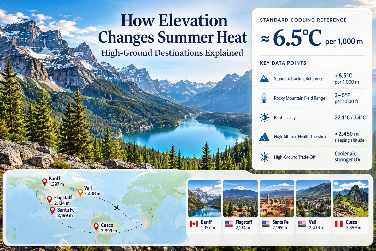
How Elevation Changes Summer Heat: High-Ground Destinations Explained
Higher ground can turn a hot summer trip into a much milder one, but elevation is not a simple thermostat. Air temperature generally falls with height, while sunshine, humidity, wind, cloud, terrain and nighttime drainage can change how that cooling actually feels. A mountain town 1,500 metres above sea level may offer a clear heat advantage over nearby lowlands, while a sunny plateau at the same elevation can still become hot during the afternoon.
The standard average lapse rate describes how air temperature commonly decreases with altitude in the lower atmosphere. It is a planning reference rather than a destination forecast.
Rocky Mountain National Park uses this approximate range to explain how conditions change while climbing through its elevation zones.
Parks Canada lists these average daily high and low temperatures for the Town of Banff at 1,397 m, showing how high ground can combine mild afternoons with cool nights.
CDC guidance notes that unacclimatized travelers sleeping at or above roughly 2,450 m can be at risk for altitude illness.
A lower air temperature does not mean weak sunshine. CDC travel guidance identifies higher elevation as a factor that increases ultraviolet exposure.
The 6.5°C-per-Kilometre Rule Is a Starting Point
Near the surface, the atmosphere usually becomes cooler with height. The standard average lapse rate is about 6.5°C for each 1,000 metres of elevation gain, according to the UCAR Center for Science Education. In U.S. units, that is about 3.6°F per 1,000 feet. Rocky Mountain National Park gives visitors a broader practical mountain range of roughly 3–5°F of cooling per 1,000 feet gained.
The distinction matters because the atmosphere does not follow one fixed lapse rate every afternoon. Moisture, cloud cover, incoming weather systems, slope orientation and whether air is rising or descending can all change the actual temperature difference between two elevations. The standard rate is most useful as a way to understand why elevation can reduce summer heat, not as a formula for predicting the exact temperature outside a hotel.
| Elevation Above Reference | Standard-Rate Cooling | Illustrative Temperature | How to Read It |
|---|---|---|---|
| 0 m | 0°C | 30.0°C | Example low-elevation starting temperature. |
| 500 m | ≈ 3.3°C cooler | ≈ 26.8°C | A modest elevation difference can become noticeable during hot weather. |
| 1,000 m | ≈ 6.5°C cooler | ≈ 23.5°C | A large enough vertical change to materially alter summer comfort in many regions. |
| 1,500 m | ≈ 9.8°C cooler | ≈ 20.3°C | Typical mountain-town territory in many ranges, although local climate remains important. |
| 2,000 m | ≈ 13.0°C cooler | ≈ 17.0°C | Strong theoretical cooling, with greater day-night range possible in dry climates. |
| 2,500 m | ≈ 16.3°C cooler | ≈ 13.8°C | Temperature relief can be substantial, but altitude acclimatization becomes a travel consideration. |
| 3,000 m | ≈ 19.5°C cooler | ≈ 10.5°C | High-altitude conditions introduce cold exposure, lower oxygen pressure and rapid weather changes. |
Real High-Ground Destinations Show More Than One Cooling Pattern
Elevation becomes more useful for summer planning when it is combined with the destination’s actual climate. Mountain valleys, high-desert cities and alpine resort towns can sit at similar elevations while producing very different afternoon temperatures, nighttime lows and weather risks.
Banff, Alberta — 1,397 m
Parks Canada lists an average July high of 22.1°C and an average low of 7.4°C for the Town of Banff. Nearby Lake Louise sits higher at 1,524 m and has a listed July average high of 20.4°C and low of 3.6°C.
The comparison is useful because the two locations are close enough to share a broad mountain climate while still showing how elevation, terrain and local setting can contribute to different temperature profiles. Parks Canada also notes that temperatures in Banff National Park fall approximately 1°C for every 200 m of elevation gain as a general planning rule.
Flagstaff, Arizona — Nearly 2,100 m
Flagstaff sits at nearly 7,000 feet above sea level at the base of the San Francisco Peaks. City planning material describes its summers as mild, with low humidity and substantial day-to-night temperature variation.
This is an important high-ground pattern in the U.S. Southwest: the city remains geographically close to much hotter desert environments, yet its elevation and forested setting create a very different summer climate. The trade-off comes later in summer when the North American monsoon can bring recurring rain and thunderstorms.
Santa Fe, New Mexico — About 2,130 m
Santa Fe stands at roughly 7,000 feet above sea level, with the Sangre de Cristo Mountains rising immediately to the east. Unlike a forested alpine destination, it combines considerable elevation with a high-desert setting and abundant sunshine.
That makes Santa Fe a useful reminder that high elevation does not automatically mean a cool afternoon. Strong sunshine and dry ground can still produce heat during the day, while the elevation and dry atmosphere can favor more noticeable cooling after sunset.
Vail, Colorado — About 2,480 m
CDC high-altitude travel guidance uses Vail as a familiar example of a destination with lodging at approximately 2,480 m. At this height, elevation is no longer only a climate characteristic; it also becomes part of health and itinerary planning for travelers arriving directly from low elevations.
The same height that helps suppress summer temperatures also means lower air pressure, stronger ultraviolet exposure and the possibility that an unacclimatized visitor will notice exertion more than expected.
Breckenridge, Colorado — About 2,927 m
The Town of Breckenridge places the community at approximately 9,604 feet, or about 2,927 m. That is high enough for summer heat reduction to be substantial compared with many surrounding lowland cities, but it also lies well above the level where altitude illness becomes relevant to unacclimatized travelers.
At this point, the practical question changes from simply “How much cooler is it?” to how much elevation is useful without creating a new travel constraint? Travelers arriving quickly from near sea level may need to balance thermal comfort against sleeping altitude and physical exertion.
Cusco, Peru — About 3,339 m
Cusco demonstrates the point where elevation becomes a dominant travel condition rather than merely a way to reduce heat. CDC information places the city at approximately 3,339 m and specifically identifies visitors to this elevation as being at risk for altitude illness.
A very high destination may offer cool conditions even at low latitude, but the thermal advantage cannot be considered independently from oxygen availability, acclimatization time, intense sunlight and potentially cold nights.
Why Two Places at the Same Elevation Can Feel Completely Different
Elevation explains only part of summer comfort. Two towns at 1,800 m can have noticeably different heat profiles because the surrounding surface and atmosphere control how quickly heat builds during the day and how efficiently it escapes at night.
Dry Mountain Air and Humid High Ground
Dry air can make shade and nighttime cooling feel more effective, but it can also allow a large difference between afternoon and overnight temperatures. More humid mountain regions may have smaller day-night swings and can feel warmer than the thermometer suggests when moisture is high.
Strong Sun Can Offset Cooler Air
High elevations receive stronger ultraviolet exposure. A destination can therefore have a mild air temperature while direct midday sun still feels intense. Air temperature and solar exposure are separate comfort variables.
Slope Direction Changes Afternoon Heating
Sun-facing slopes can heat substantially during clear weather, while shaded forests, narrow valleys and slopes facing away from the strongest afternoon sun can remain cooler. A destination’s listed elevation does not describe where a hotel, trail or town sits relative to that terrain.
Cloud, Wind and Mountain Exposure Matter
Cloud can suppress daytime heating, while exposed ridges can feel cooler because of wind. Sheltered plateaus may become much warmer during calm, sunny weather. Regional weather patterns therefore remain important even when elevation appears favorable.
Elevation Often Changes the Night More Than Travelers Expect
High-ground destinations are frequently chosen because afternoons are cooler, but nighttime recovery can be just as important during a summer trip. Dry mountain air and longwave heat loss after sunset can produce large day-night temperature ranges, making sleeping conditions far more comfortable than in hot lowlands where heat remains trapped overnight.
Afternoon Cooling Is Not Guaranteed
Strong sun can still heat exposed high plateaus and mountain towns. During regional heatwaves, even elevated destinations can reach temperatures that are unusually high for their climate. Elevation usually reduces the starting temperature relative to lower terrain, but it does not block the heatwave itself.
Cool Nights Can Be the Larger Advantage
Banff’s published July averages illustrate this clearly: an average high around 22°C is paired with a low near 7°C. A traveler focused on sleep comfort may therefore gain more from a high-ground destination than someone judging the trip only by its warmest afternoon hour.
Mountain terrain can also reverse the simple “higher is colder” pattern during calm nights. Rocky Mountain National Park describes how cooled air can descend slopes and collect in valleys. This cold-air drainage can make a valley floor temporarily colder than a slope above it, especially overnight.
National Park Service explanation of mountain cooling and drainage flows
Elevation Bands Change the Balance Between Heat Relief and Altitude
There is no universal elevation where summer becomes comfortable. Latitude and regional climate remain decisive. These bands are more useful as a planning framework for understanding what tends to change as sleeping elevation rises.
| Approximate Elevation | Likely Heat Effect | Night Pattern | Main Trade-Off | Planning Use |
|---|---|---|---|---|
| 500–1,000 m | Modest to meaningful cooling | Often somewhat cooler | Local climate can outweigh altitude | Useful where nearby lowlands are only moderately hot |
| 1,000–1,800 m | Clearer temperature advantage in many regions | Cool nights increasingly common in dry climates | Weather can become more variable | Strong range for mountain towns without extreme altitude |
| 1,800–2,400 m | Substantial potential reduction in summer heat | Large day-night range can occur | Stronger sun, dry air and rapid weather shifts | Useful for travelers prioritizing lower daytime heat and cooler sleep |
| 2,400–3,000 m | Strong elevation influence | Cool or cold nights possible | Altitude illness becomes relevant | Check sleeping altitude and ascent pattern, not only temperature |
| Above 3,000 m | Very strong high-altitude climate influence | Cold nights possible even in summer | Acclimatization becomes a primary concern | Choose for its full high-altitude environment rather than heat relief alone |
High Ground Replaces Some Heat Problems With Mountain Problems
Choosing elevation can reduce exposure to persistent lowland heat, but the change in environment introduces risks that are easy to overlook when attention is focused only on temperature.
Ultraviolet Exposure Increases
CDC travel guidance identifies high elevation as a setting where ultraviolet exposure can be stronger. Cooler air should not be interpreted as weaker sun, especially around midday.
Weather Can Change Quickly
Rocky Mountain National Park warns that summer mountain conditions can change rapidly and that temperature drops of 10–20°F can occur. Afternoon thunderstorms and strong winds are also normal high-country hazards in parts of the Rockies.
Sleeping Altitude Matters
CDC guidance states that any unacclimatized traveler proceeding to a sleeping altitude of about 2,450 m or higher can be at risk for altitude illness. Rapid arrival from low elevation increases the importance of itinerary design.
Evenings Can Become Genuinely Cold
A temperature pattern that feels pleasant at 3 p.m. can require warm clothing after sunset. This is particularly important for camping, outdoor dining, early-morning transport and long hikes returning late in the day.
Morning Activity Can Matter More
Some mountain climates develop recurring afternoon convection during summer. Flagstaff’s monsoon pattern and the Rocky Mountains’ afternoon thunderstorm tendency are examples where daily timing can matter as much as average temperature.
Elevation Does Not Escape Regional Smoke
Mountain and forest regions can still experience wildfire smoke during dry summers. A cooler destination should therefore be checked for current air quality, fire restrictions and access conditions close to departure.
What to Check Before Choosing a High-Ground Summer Base
A destination’s elevation is most useful when combined with a small set of climate and access measurements. The elevation number alone cannot show whether a trip will actually provide relief from summer heat.
Check the Actual Summer Daytime Normal
Compare average maximum temperatures for the specific month of travel. A 1,500 m town in a hot continental interior can still be warmer than a lower coastal destination exposed to cool maritime air.
Check the Average Nighttime Minimum
For travelers trying to avoid warm hotel rooms or persistent overnight heat, the minimum temperature may be more decision-relevant than the daytime maximum.
Separate Day-Trip Height From Sleeping Height
A cable car, scenic road or trail may reach 3,000 m while the accommodation remains at 1,500 m. That itinerary has a different altitude-health profile from sleeping at 3,000 m for several nights.
Look at Shade and Exposure
Forested high ground, exposed plateaus and dense mountain towns can produce different thermal experiences despite similar elevations. Tree cover, building materials and afternoon sun orientation all matter.
Verify Seasonal Access
Higher roads, alpine facilities and mountain transport can have shorter operating seasons than the towns below. Early-summer snow or storm closures may limit access to the elevation that provides the strongest cooling.
Recheck the Forecast Near Departure
Climate averages describe what is typical, not what will happen during a specific heatwave. A high-ground destination can still experience unusually warm weather, thunderstorms, smoke or cold snaps.
Elevation Is a Heat Lever, Not a Heat Guarantee
The strongest use of elevation is comparative: when two destinations sit within the same broad region, moving several hundred or several thousand metres upward usually changes the summer temperature environment in a meaningful direction. The standard 6.5°C-per-1,000-m lapse rate explains why, but actual comfort still depends on regional climate, humidity, cloud, wind, shade and nighttime behavior.
Moderately elevated destinations around 1,000–2,000 m can provide a useful balance between reduced summer heat and straightforward travel for many visitors. Higher bases around 2,400–3,000 m can push temperatures lower but add stronger UV exposure, colder nights and altitude considerations. Above 3,000 m, the destination should be treated as a high-altitude environment first and a summer heat alternative second.
For heat-focused trip planning, the most informative combination is therefore not elevation alone. Compare elevation, average summer maximum, average nighttime minimum, local humidity or cloud pattern, sleeping altitude and current weather risk. Together, those factors reveal whether higher ground is likely to provide meaningful summer relief without creating a larger planning problem.