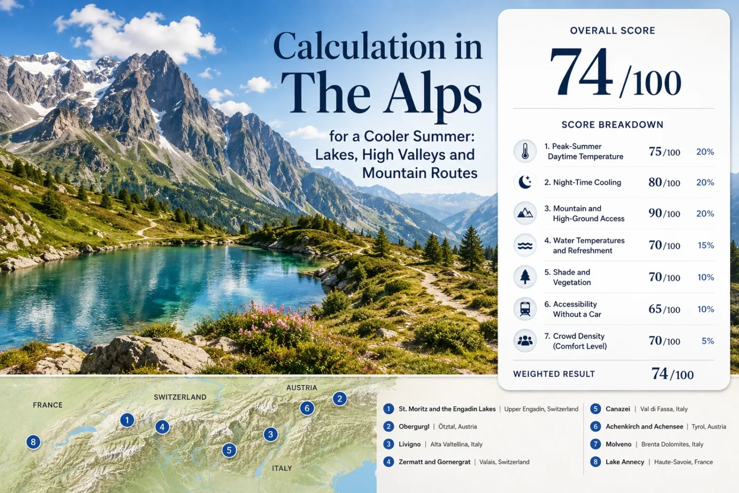
The Alps for a Cooler Summer: Lakes, High Valleys and Mountain Routes
Summer temperature in the Alps changes more with overnight elevation and vertical access than with national borders. A lake town at 450–900 metres can have warm afternoons even when high peaks fill the horizon, while villages around 1,500–1,900 metres can keep both days and nights much cooler. Eight Alpine bases show three distinct ways to reduce peak-summer heat: sleep high, stay beside elevated water, or use railways and lifts to move above a warmer valley during the hottest part of the day.
Austria, Switzerland, Italy and France are represented by the same bases used in the map, score and comparison.
Annecy forms the low-lake end of the range; Obergurgl represents the high-valley extreme.
The median combines the representative climate values of all eight lodging bases rather than summit temperatures.
Its July–August planning normal is about 16.7°C for the average daily maximum and 6.7°C for the minimum.
The rack railway rises from roughly 1,605 m in Zermatt to 3,089 m at Gornergrat without requiring a car.
Eight Alpine Bases from Lake Annecy to the Ötztal
The markers separate high-lake systems, high overnight valleys and lower lake bases with rapid access toward higher terrain. Positions are planning centres, not guaranteed trailheads, legal parking areas or exact viewpoints.
Use the named Google Maps link in each destination card for navigation. Mountain-lift terminals, pass roads, swimming areas and parking arrangements can sit away from the settlement-centre marker.
Alpine Lake and High-Valley Cooler Escape Suitability Score
The score measures the eight selected Alpine bases rather than the whole mountain range. It combines disclosed climate, elevation, water-and-forest access, transport and peak-pressure factors. It is an editorial suitability index, not an official climate classification or weather forecast.
Weighted total: 100×0.25 + 86×0.20 + 100×0.15 + 100×0.15 + 100×0.10 + 80×0.10 + 40×0.05 = 92.2 → 92/100
Method: Route count adds no bonus. Each destination carries equal weight, route values are reduced to the median within each factor, and the seven fixed weights are then applied.
High Lakes, Elevated Villages and Split-Level Alpine Bases
The eight bases are deliberately different. Some place the hotel room inside the cool-air zone; others trade warmer afternoons for swimming, direct rail or easier town services.
St. Moritz and the Engadin Lakes
St. Moritz sits at roughly 1,822 metres, so the overnight base already captures much of the cooling effect that lower Alpine lake towns seek through day trips. The representative July–August values are about 19.5°C by day and 7.0°C at night. Lake St. Moritz, Silvaplana, Champfèr and Sils keep water close without dropping back to a low valley floor.
Summer 2026 has an unusual transport detail: the St. Moritz Dorf–Chantarella–Corviglia funicular route is closed for major maintenance. Corviglia remains accessible through St. Moritz Bad–Signal and Celerina–Marguns alternatives. Corvatsch operates through the main summer period, so the high-ground network remains broad despite the closure.
Obergurgl
Altitude is the main cooling mechanism. Obergurgl’s station base is about 1,941 m, with a July–August mean daily maximum near 16.7°C and mean minimum near 6.7°C. Its 1991–2020 hot-day normal records no 30°C days in the two target months.
The trade-off is water access. Obergurgl scores much lower for major lake and broad forest access than Achensee, Molveno or Annecy, making it a stronger choice for low air temperatures than for a swim-centred stay.
Livigno
Livigno combines a roughly 1,816 m lodging base with Lake Livigno and a long enclosed high valley. Representative July–August values around 20.0°C for daytime maxima and 7.0°C for minima place it much closer to high Swiss valley conditions than to the warmer Italian lowlands.
The lake contributes open water and valley airflow, but it should not be treated as a warm-water beach substitute. The stronger thermal advantage is sleeping at altitude. Summer interurban buses connect Livigno with Bormio, Tirano, Pontresina, Poschiavo and Zernez, although the arrival chain remains longer than at St. Moritz, Zermatt or Annecy.
Zermatt and Gornergrat
Zermatt starts high at about 1,608 m, with representative July–August values near 19.8°C by day and 8.3°C at night. The village is car-free and reached by rail, so the low-heat lodging base does not depend on a mountain-road arrival.
The Gornergrat Railway creates one of the largest easy vertical shifts in the set, rising from Zermatt to 3,089 m. For the 2026 main summer timetable, trains run every 24 minutes from 08:00 between April 20 and November 1, with the first departure from Zermatt at 07:00.
Canazei Beneath the Sella and Marmolada Corridors
Canazei’s accommodation base is close to 1,465 m. Representative July–August values near 21.0°C by day and 8.0°C at night give the village a strong heat buffer before any lift is used.
The 2026 Panorama Pass network covers more than 30 summer lifts across Val di Fassa. Local buses and the seasonal Fassa Express reduce short car trips inside the valley, but reaching Canazei from a major railway corridor still takes more coordination than reaching the Swiss direct-rail bases.
Achenkirch and Achensee
Achensee is the strongest example of an Alpine lake where water and elevation work together. Achenkirch’s station sits near 931 m, with July–August normals around 21.5°C for the mean daily maximum and 10.5°C for the minimum.
The normal hot-day share is about 3.9%, far below Annecy’s lower basin. Rail passengers use Jenbach as the gateway and continue by regional bus, with the transfer to the lake taking roughly 25 minutes under the normal service pattern.
Molveno Beneath the Brenta Dolomites
Molveno sits at about 864 m, low enough for a more usable swimming season but also low enough for warmer afternoons. The representative July–August profile is approximately 25.2°C by day and 13.0°C at night, with a 30°C threshold share near 5%.
Its cooling value comes from the combination rather than the thermometer alone: a large lake, wooded shoreline and rapid movement toward Pradel and the Brenta Dolomites. That makes Molveno more suitable for a water-first day than for someone seeking the lowest possible lodging temperature.
Annecy and Lake Annecy
Annecy is the useful counterexample to the idea that an Alpine setting automatically means a cool summer base. The lake sits around 448 m, and Annecy-Meythet’s 1991–2020 July–August averages are about 26.3°C for the daily maximum and 14.3°C for the minimum.
The published normal also indicates a much larger 30°C exposure than at the high-valley bases: roughly 24.2% of July–August days in the threshold-frequency calculation. Direct rail, lake swimming and access toward the Bauges and Bornes still create a flexible summer structure.
How the Eight Bases Change the Daily Cooling Strategy
A high village and a low lake can both work in summer, but they solve different problems. The most useful comparison is where the cool air is available: in the hotel base, beside the water or only after gaining elevation.
| Base | Approx. Elevation | July–August Day / Night | Cooling Pattern | Car-Light Pattern | Main Trade-Off |
|---|---|---|---|---|---|
| St. Moritz and the Engadin Lakes | 1,822 m | 19.5°C / 7.0°C | High lake + high valley | Direct rail, buses and mountain transport | Cold water; 2026 Corviglia access changes |
| Obergurgl | 1,941 m | 16.7°C / 6.7°C | High overnight valley | Rail gateway + valley bus | Limited large-lake access; shorter lift season |
| Livigno | 1,816 m | 20.0°C / 7.0°C | High valley + reservoir | Summer interurban buses | Longer arrival chain |
| Zermatt and Gornergrat | 1,608 m | 19.8°C / 8.3°C | High village + vertical rail | Car-free rail base | High booking and excursion pressure |
| Canazei | 1,465 m | 21.0°C / 8.0°C | Dolomite high valley + lifts | Valley buses; rail transfer required | Sella road and lift congestion |
| Achenkirch and Achensee | 931 m | 21.5°C / 10.5°C | Elevated swimming lake | Jenbach rail + regional bus | Exposed shoreline can warm in afternoon sun |
| Molveno | 864 m | 25.2°C / 13.0°C | Swimming lake + rapid mountain access | Regional bus access | Warmer afternoons and lakeshore pressure |
| Annecy and Lake Annecy | 448 m | 26.3°C / 14.3°C | Low Alpine lake + nearby high ground | Direct rail and local buses | Basin heat can persist at lake level |
Obergurgl, Livigno and the Engadin Put the Hotel Inside the Cool-Air Zone
Obergurgl Minimizes the Need for a Midday Escape
At 1,941 m, Obergurgl begins higher than many Alpine day excursions end. A 16.7°C July–August daytime normal means the lodging base itself performs most of the temperature work. The main planning questions shift toward cold evenings, wind, thunderstorms and lift operating dates.
The Engadin Adds Lakes Without Dropping Back to Low Elevation
St. Moritz, Silvaplana and Sils remain around the 1,800 m band. Water access therefore does not require returning to a 400–900 m basin. That combination separates the Upper Engadin from lower lake systems where swimming access and low air temperature pull in opposite directions.
Livigno Trades Easy Arrival for a High Overnight Base
Livigno keeps nights near the colder end of the eight-route range, but Tirano and other rail gateways sit well outside the valley. Once the longer approach is complete, daily travel can remain local instead of repeating a large vertical commute.
Summit height is not the same as lodging climate. Valley orientation, cloud, wind, inversions and local exposure prevent a simple universal temperature-per-1,000-metres rule from describing every Alpine day. Base elevation still provides a more useful first filter than the height of the peaks visible from the window.
Achensee, Molveno and Annecy Show Why Lake Elevation Changes the Summer Experience
All three offer major water access. Their overnight elevations differ by nearly 500 metres, producing three distinct combinations of swimming conditions and atmospheric cooling.
Achensee Keeps Water Near 1,000 Metres
Achenkirch’s 931 m station base keeps the July–August daytime normal near 21.5°C while maintaining a mean minimum around 10.5°C. Karwendel forest and mountain access add alternatives when open shoreline becomes sunny and exposed.
Water and overnight cooling reinforce each other rather than competing.
Molveno Gives More Temperature Away for Swimming
Molveno’s 864 m base is only modestly lower than Achensee, yet its representative daytime value is about 25.2°C. Regional climate, basin exposure and local geography matter alongside elevation. The lake remains useful because cooling can come from water contact, forest shade and rapid access toward Pradel.
Annecy Is Alpine Without Being a High-Altitude Base
At roughly 448 m, Annecy is lower than every other base in the set. A 26.3°C July–August mean maximum and much higher 30°C frequency make it unsuitable as evidence that any Alpine lake is automatically cool. Its advantage is flexibility: direct rail, swimming and mountain terrain remain close together.
Gornergrat, Corviglia and the Dolomite Lifts Turn Altitude into a Daytime Tool
Vertical transport changes what a warm Alpine base can do, but it does not change where the visitor sleeps. A railway or cable car reaching 2,500–3,000 metres can create a very cool midday excursion while the hotel at 450–900 metres remains warm after sunset.
Zermatt Reaches 3,089 Metres Without a Road
The Gornergrat Railway begins directly opposite Zermatt’s main rail station and reaches 3,089 m. Its 2026 main summer timetable gives a regular 24-minute service pattern. Zermatt therefore combines a high overnight base with an even larger daytime elevation range.
The Engadin Has a 2026 Access Detour
St. Moritz Dorf–Chantarella–Corviglia is closed for major maintenance in summer 2026. Signal and Celerina alternatives keep Corviglia and Piz Nair accessible, but the normal village-centre route should not be assumed. Corvatsch and Furtschellas continue with their own published summer operating windows.
Canazei Uses a Network Rather Than One Summit Ride
Val di Fassa’s 2026 Panorama Pass covers more than 30 lifts. That allows the daily route to shift between different Dolomite sectors instead of committing to one high road. The return time of the final lift still sets a harder limit than the temperature itself.
Obergurgl Needs Less Vertical Rescue but Has a Shorter Window
Obergurgl is already near 2,000 m, so a closed lift does not return the overnight climate to a hot low valley. Hohe Mut access nevertheless changes what can be reached easily: its planned 2026 operation runs from July 15 through September 13, with construction-related changes to Section I.
Peak Access and Peak Pressure Arrive Together in the Alpine Summer
The lowest-heat period, the widest mountain-transport window and the easiest swimming period do not begin on the same date. July and August require a trade between temperature, lift coverage, water use and visitor pressure.
Early July: High Valleys Are Ready Before Every Lift Is
Upper Engadin mountain railways already have broad summer service by late June, but individual lines differ. Obergurgl’s Hohe Mut operation does not begin until July 15 in 2026. Residual snow can also remain on shaded high trails even while village paths are fully summer-like.
Works for: Travellers who value cooler lodging and lower pressure more than having every high lift available.
Mid-July to Mid-August: The Vertical Network Is Widest
Gornergrat, Engadin mountain transport, Val di Fassa lifts and the main Austrian high-valley services overlap strongly in this period. The same weeks also concentrate accommodation demand, Sella traffic, lakeshore parking pressure and busy mountain-rail departures.
Warm lower basins such as Annecy and Molveno benefit most from planning high-ground movement before midday rather than waiting for the shore to become uncomfortable.
Late August: Cooler Nights Arrive Before Most Summer Transport Ends
Night cooling normally becomes more pronounced while much of the lift and rail infrastructure remains active. Gornergrat continues through autumn, Engadin systems retain broad late-summer operation, and Hohe Mut remains scheduled through September 13.
Lake swimming becomes less predictable at the highest bases, while Achensee, Molveno and Annecy can retain a more water-oriented day structure depending on the weather.
Cool air at altitude does not remove sun exposure or mountain-weather risk. Open terrain above the tree line can combine low air temperature with strong solar radiation, and summer convection can produce thunderstorms that interrupt lifts or make exposed ridges unsuitable. The valley temperature should never be used as a substitute for the mountain forecast.
For the strongest overnight heat relief, the route logic points toward Obergurgl, the Upper Engadin, Livigno and Zermatt. Achensee keeps a stronger balance between swimming and cool nights. Molveno accepts warmer air for a more lake-centred summer, while Annecy works as a low Alpine water base with higher terrain available when the basin heats up. Lift status, thunderstorm timing, pass-road conditions and the final descent should be checked on the day of any high route.