Bosnia and Herzegovina Coolcation: Rivers, Mountain Towns and Forested Valleys
Bosnia and Herzegovina’s summer comfort is shaped by rapid changes in elevation. River towns can still become hot in July and August, but forested Dinaric valleys, lake basins and mountain accommodation zones provide cooler nights and high-ground alternatives within the same route.
The route set covers the Una, Pliva, Vrbas, Neretva and Sutjeska systems alongside three high Dinaric bases.
Masna Luka and the lake plateau sit close to 1,180 metres, between Čvrsnica and Vran.
An urban base, tram connections and the cable car create the simplest transition from valley streets to forested high ground.
The Pliva waterfall, two lakes and the Vrbas valley are concentrated within a short local road corridor.
The route rises from the Drina basin toward Tjentište, Perućica and mountains exceeding 2,000 metres.
Several river bases exceed 28°C on typical peak-summer afternoons, while most selected routes retain meaningful overnight cooling.
River Corridors, Mountain Bases and Forest Valleys
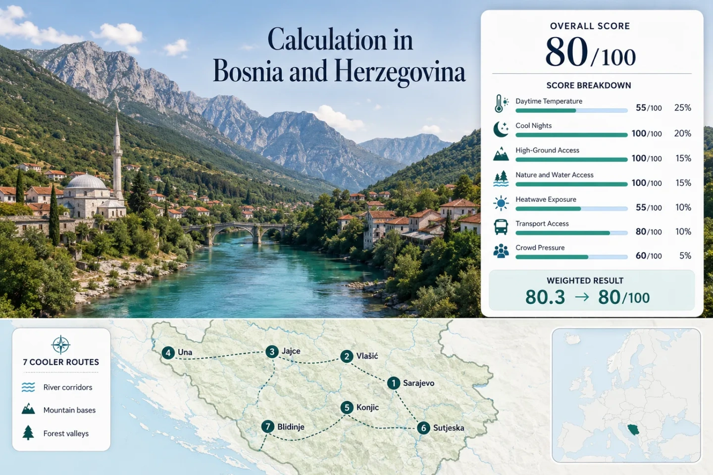
The markers connect seven bases that combine water access with nearby forest, plateau or mountain terrain. Their summer character differs sharply according to elevation and valley exposure.
This marker map is built for planning orientation. Marker positions use approximate public location centres where exact viewpoints, trailheads, legal parking areas or pull-offs are not specified. Markers do not guarantee legal parking or navigable mountain-road access.
Bosnia and Herzegovina Cooler Escape Suitability Score
This transparent editorial suitability index uses disclosed climate, landscape, access and pressure factors. It is not an official climate classification or a weather forecast. Every route carries equal weight, and the number of routes does not create a score bonus.
Weighted total: 55×0.25 + 100×0.20 + 100×0.15 + 100×0.15 + 55×0.10 + 80×0.10 + 60×0.05 = 80.3 → 80/100
Una Waterfalls, Pliva Lakes and High Dinaric Valleys
The seven routes are not uniformly cool. The strongest plans use a river or historic-town base while keeping a forested mountain, lake plateau or high trail within practical reach.
Sarajevo and Trebević
Car-light access is the defining advantage. Sarajevo sits near 518 metres in the Miljacka basin, while the cable car reaches the forested Trebević slope in roughly eight to nine minutes. The mountain summit rises above 1,600 metres.
The valley can become hot during clear afternoon weather, so the cooling benefit comes from changing elevation rather than remaining in the city centre all day.
Travnik and Vlašić
Babanovac accommodation sits near 1,260 metres, roughly 700 metres above Travnik. That vertical separation produces one of the clearest town-to-mountain cooling shifts in central Bosnia.
Target-period proxy: Approximately 24°C by day and 11°C at night for the high accommodation zone. Paljenik rises to about 1,933 metres, extending hiking terrain well above the lodging base.
Jajce and the Pliva Lakes
Jajce’s official climate station is near 428 metres. The town stands where the Pliva enters the Vrbas, while the Great and Small Pliva Lakes lie about five kilometres from the centre.
The water system improves route flexibility but does not eliminate hot afternoons. Early waterfall visits, shaded lake edges and cooler evenings create a more balanced schedule than uninterrupted midday sightseeing.
Swimming comfort and low walking temperatures are not the same window: lake use is strongest during warmer weather, while town walking is easier in June or September.
Bihać and Una National Park
The river is the main cooling landscape, not a guarantee of low daytime heat. Bihać’s official station is near 246 metres, and the July–August proxy reaches about 29°C by day and 16°C at night.
Una National Park covers approximately 19,800 hectares around the Una gorge, waterfalls and forested border terrain. Štrbački Buk and Martin Brod require separate road planning from a Bihać accommodation base.
Konjic and Boračko Lake
Konjic is a rail-accessible Neretva town, but its valley position allows pronounced heat during settled weather. Boračko Lake lies about 20 kilometres away at roughly 397 metres, beneath the wooded slopes of Prenj and Visočica.
The route works through activity separation: early Neretva walks, lake time during the warmest hours and higher trail access when conditions are stable.
Foča and Sutjeska National Park
Foča occupies the Drina basin at roughly 400 metres. Tjentište lies about 25 kilometres south, where the route enters the Sutjeska valley between Zelengora, Volujak and Maglić.
Altitude range: Approximately 560 metres at Tjentište to 2,386 metres on Maglić. The route-centre proxy is about 26°C by day and 13°C at night during July and August.
Perućica adds dense primeval forest, while Zelengora’s glacial lakes provide high-country alternatives to the lower valley. Access beyond Tjentište becomes increasingly road- and trail-dependent.
Blidinje and Masna Luka
Blidinje provides the clearest low-heat accommodation logic in the route set. The lake and Masna Luka area sit close to 1,180 metres between Čvrsnica and Vran.
The plateau’s weakness is transport. Reaching the park and moving between Masna Luka, Risovac and the lake normally requires a car, while fuel, food and weather contingencies should be handled before entering the higher road network.
Dinaric Altitude Changes the Same-Day Temperature Plan
The most useful cooling mechanism is the ability to change elevation without abandoning the route. Several selected bases connect a warm historic centre to substantially higher terrain in less than an hour.
Miljacka Basin to Trebević Forest
Sarajevo’s afternoon heat can be replaced by a rapid cable-car ascent. The upper station is not the summit, but it removes much of the slow road transfer associated with other Bosnian mountain routes.
Travnik Days and Vlašić Nights
Travnik and Babanovac should be treated as different thermal bases. Sleeping on Vlašić creates a larger night-cooling advantage than returning to the Lašva valley after every mountain day.
Tjentište, Perućica and Maglić
Sutjeska contains the largest usable elevation range, but the transition is slower and more dependent on local roads, trail conditions and mountain-weather judgement.
Starting High at Blidinje
Blidinje removes the daily ascent problem by placing accommodation directly on a high plateau. The trade-off is limited scheduled transport and fewer fallback services during sudden weather changes.
Which River-and-Mountain Pairing Matches the Trip?
The comparison uses the same seven routes shown on the map, in the score calculation and in the destination portfolio.
| Route | Lowest-Heat Strategy | Water Access | Without a Car | Night-Cooling Strength | Main Pressure Point |
|---|---|---|---|---|---|
| Sarajevo–Trebević | Use the cable car during hot afternoons | Miljacka corridor | Strong | Strong | August event demand |
| Travnik–Vlašić | Sleep at Babanovac rather than in the valley | Lašva system | Moderate | Very strong | Weekend road traffic |
| Jajce–Pliva Lakes | Separate early town walking from lake time | Pliva Lakes and Vrbas | Moderate | Strong | Waterfall and lakeside concentration |
| Bihać–Una | Use shaded river sectors and forest roads | Una River and waterfalls | Moderate to base; weak inside park | Moderate | Štrbački Buk and rafting demand |
| Konjic–Boračko Lake | Combine rail access with a lake transfer | Neretva and Boračko Lake | Strong to Konjic; limited to lake | Strong | Lake and rafting weekends |
| Foča–Sutjeska | Move from Tjentište toward higher park zones | Drina, Sutjeska and glacial lakes | Limited | Very strong | Scarce specialist lodging |
| Blidinje–Masna Luka | Stay on the plateau throughout the trip | Blidinje Lake and springs | Weak | Very strong | Limited services and weekend arrivals |
Neretva Rail, Trebević Cable Car and Car-Dependent Parks
Bosnia and Herzegovina’s cooler routes divide into three distinct access systems. Choosing between them changes how easily a hot afternoon can be replaced by higher terrain.
Sarajevo–Konjic Rail Corridor
ŽFBH services place Konjic on the Sarajevo–Čapljina line. Rail removes the need for a car between the two towns, but Boračko Lake, Prenj trailheads and rafting camps still require local transport.
Direct Lift to Trebević
The Trebević cable car is the only selected route where urban public transport connects directly with a high forest zone. Published hours should be checked on the operating day.
Una, Sutjeska and Blidinje by Road
These landscapes cover dispersed entrances, valleys and trailheads. A single park name is not a sufficient navigation destination, and public transport rarely solves the final kilometre.
River Swimming and Low-Heat Hiking Use Different Windows
One date range cannot describe every activity. Warmer water, lower daytime heat, trail access and booking pressure peak at different points between late spring and early autumn.
Late May to June
Lower-heat walking window: Strong for Jajce, Sarajevo, Travnik and Konjic before the most persistent valley heat. High trails can remain wet, storm-prone or affected by late snow patches.
July to August
Water-use window: Stronger for the Una, Pliva Lakes and Boračko Lake. Blidinje, Vlašić and high Sutjeska terrain provide more reliable daytime relief than the river towns themselves.
Event and Weekend Peaks
Sarajevo demand rises around major August events. Waterfall viewing areas, rafting bases and lakeside parking can fill earlier on clear weekends even when national accommodation occupancy remains moderate.
Early to Mid-September
Balanced shoulder window: Cooler town walking and lower booking pressure often improve, while lake swimming becomes less dependable and daylight shortens.
Sarajevo Events, Waterfall Weekends and Limited Mountain Lodging
National occupancy figures do not describe the local bottlenecks that matter most on these routes.
Sarajevo’s August Accommodation Cycle
The city has the broadest room supply in the route set, but large cultural events create concentrated demand. Trebević visits are easier when accommodation is secured before event-week pricing and availability tighten.
Una and Jajce Parking Concentration
Štrbački Buk, central Jajce and popular Pliva Lakes areas receive more concentrated day-trip traffic than the wider destination. Early arrival matters more than regional hotel occupancy.
Sutjeska and Blidinje Room Supply
Lower visitor numbers do not guarantee last-minute rooms. Specialist camps, mountain lodges and plateau accommodation have smaller inventories than Sarajevo, Bihać or Konjic.
Weather Backup Without Leaving the Region
Sarajevo, Travnik, Jajce, Bihać and Konjic retain indoor services and historic centres during storms. Blidinje and high Sutjeska plans need a more deliberate low-elevation backup.