Montenegro in Summer: Mountain Lakes, High Roads and Adriatic Heat Escapes
Montenegro’s Adriatic coast can remain hot through July and August, but the country rises quickly into limestone plateaus, glacial-lake basins and mountain settlements. Žabljak, Bjelasica and Lovćen create three distinct cooling strategies: sleeping above 900 metres, spending the day beside forested lakes, or climbing from the coast to high roads where temperature, wind and cloud patterns change within a short distance.
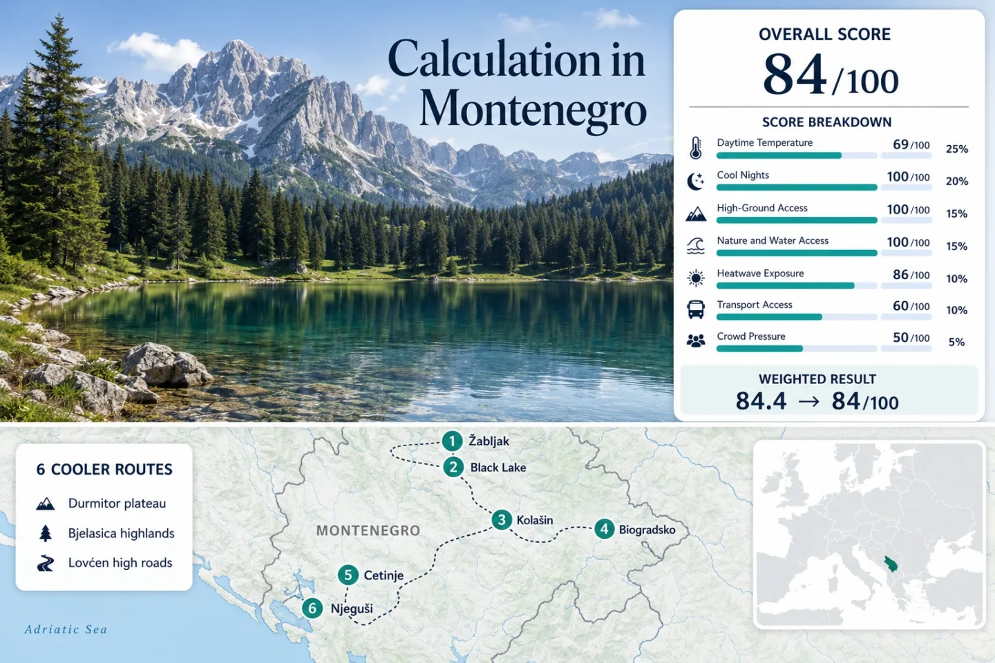
Two Durmitor bases, two Bjelasica areas and two Lovćen approaches form the shared map, score and comparison set.
The 1,456-metre town has a July–August normal maximum close to 22°C and nights averaging near 9°C.
The official 76-kilometre Durmitor Ring reaches its highest paved point below Štuoc.
The town sits on Montenegro’s Bar–Podgorica–Bijelo Polje railway, unlike the road-dependent Durmitor and Lovćen circuits.
The national park spans 939–1,749 metres while the official Sea and Heights road reaches 1,550 metres above the coast.
From Durmitor’s Lake Basin to the Lovćen Serpentines
The markers connect Montenegro’s northern mountain towns and forest lakes with the high ground immediately above Cetinje and the Bay of Kotor. The numbered sequence matches the route portfolio.
This marker map is built for planning orientation. Marker positions use approximate public location centres where exact viewpoints, trailheads, legal parking areas or pull-offs are not specified. Markers show selected cooler-route regions, not guaranteed legal parking or exact navigation points.
Montenegro Mountain and High-Road Suitability Score
This is a transparent editorial suitability index based on disclosed climate, landscape, access and pressure factors. It is not an official climate classification or a weather forecast.
Weighted total: 69×0.25 + 100×0.20 + 100×0.15 + 100×0.15 + 86×0.10 + 60×0.10 + 50×0.05 = 84.4 → 84/100
Method: Route count does not add bonus points. Each route carries equal weight, route-level values are combined using the median, and the seven fixed factor weights are then applied.
Glacial Lakes, Railway Highlands and Roads Above the Adriatic
The six routes separate overnight cooling from daytime excursions. Žabljak and Kolašin work as multi-night mountain bases, while the Lovćen routes are particularly useful when a coastal itinerary needs a high-ground interruption.
Žabljak and Durmitor Ring
Žabljak is the clearest low-temperature base in the set. The town stands near 1,456 metres, while the official Durmitor Ring covers 76 kilometres and reaches a paved high point of 1,959 metres below Štuoc. The Žabljak station’s July–August normals are approximately 21.8°C for daytime maxima and 9.2°C for minima.
The complete circuit normally requires several hours because long sections are narrow and stopping space is limited. Starting early reduces opposing traffic and leaves time for short walks without turning the road into a rushed day trip.
Black Lake and Savin Kuk
Black Lake lies in a forested basin roughly three kilometres from central Žabljak and close to 1,416 metres above sea level. The route inherits the Žabljak station values of about 21.8°C by day and 9.2°C at night, while shade around the lake changes midday exposure more than an open high-road stop.
The lake is the easier low-effort option; Savin Kuk adds the stronger altitude change. Access begins from the same accommodation base, but walking conditions, lift operation and exposed upper terrain require separate checks.
Kolašin and Bjelasica
Kolašin’s 954-metre base is warmer than Žabljak, with July–August station normals near 25.6°C for maximum temperature and 10.3°C for minimum temperature. Its advantage is logistical: the town has direct railway access on the Bar–Podgorica–Bijelo Polje corridor.
A car remains useful for flexible Bjelasica trailheads, but the overnight base can work without one. That makes Kolašin a practical compromise for travellers who want mountain nights without committing to Montenegro’s more isolated panoramic roads.
Biogradsko Lake and Primeval Forest
Biogradska Gora extends from 832 to 2,139 metres and protects a 1,600-hectare primeval-forest reserve. Lake Biograd sits near 1,094 metres, around 18 kilometres from the representative Kolašin station and roughly 140 metres higher.
The 25.6°C daytime station normal is therefore a conservative valley-base reference rather than a precise lakeshore reading. Forest canopy, water and elevation can reduce direct solar load, but summer rain and damp air may replace heat with a cooler, wetter form of discomfort.
Cetinje to Ivanova Korita
Cetinje stands near 671 metres, while Ivanova Korita lies about ten kilometres away on substantially higher Lovćen terrain. The official park elevation range is 939–1,749 metres, so the route creates a rapid climb from an inland city base into beech forest and high karst.
The Cetinje station fallback gives approximately 27.2°C for July–August daytime maxima and 11.7°C for minima. Those values describe the lower city, not the higher park interior, making Ivanova Korita a useful afternoon alternative when Cetinje or the coast is warmer.
Good for: Travellers who want a cultural city base, short mountain transfers and cooler evenings without driving the full Bay of Kotor serpentines.
Njeguši–Krstac–Lovćen High Road
The old road rises sharply from the Bay of Kotor toward Njeguši and the Lovćen plateau. The official Sea and Heights route reaches 1,550 metres below the mausoleum, with the wider park climbing to Štirovnik at 1,749 metres.
The useful metric is the vertical transition rather than the Cetinje proxy temperature. In a short horizontal distance, the route moves from Adriatic heat to an exposed mountain road where wind, cloud and temperature can differ markedly from Kotor.
Public transport is not flexible enough for a full high-road circuit. Confident driving, early timing and avoiding oversized vehicles are more important here than route mileage.
Route Trade-Offs from Durmitor to Lovćen
The lowest daytime temperatures, easiest non-driving arrival and quickest relief from Adriatic heat occur on different routes. The comparison keeps all six assessed areas in the same order as the map and score.
| Route | Elevation or Climate Reference | Lower-Heat Use | Transport Pattern | Main Limitation |
|---|---|---|---|---|
| Žabljak and Durmitor Ring | 1,456 m base; 21.8°C normal maximum | Multi-night base and full high-road day | Road arrival; car strongly useful | Narrow 76 km circuit, fog and limited stopping space |
| Black Lake and Savin Kuk | Lake near 1,416 m; Žabljak climate reference | Shaded lake walk or higher-terrain excursion | Bus to Žabljak, then walk or local transfer | Concentrated entrance and parking pressure |
| Kolašin and Bjelasica | 954 m base; 25.6°C normal maximum | Cool-night base with flexible mountain days | Direct railway access | Town afternoons are warmer than Žabljak |
| Biogradsko Lake and Primeval Forest | Lake near 1,094 m; park reaches 2,139 m | Forest shade, lake air and higher trails | Rail to wider area, then road transfer | Rain, damp conditions and finite lake-road capacity |
| Cetinje to Ivanova Korita | 671 m city base; park begins at 939 m | Short high-ground break from Cetinje or the coast | Bus to Cetinje, private onward transfer | Cetinje station understates the park’s elevation contrast |
| Njeguši–Krstac–Lovćen High Road | Paved route reaches 1,550 m | Fast vertical escape from Bay of Kotor heat | Car-dependent panoramic circuit | Narrow serpentines, rockfall risk and opposing traffic |
Durmitor Ring: 1,959 Metres, Narrow Pavement and Snowmelt Timing
Why 76 Kilometres Requires Most of a Day
The Durmitor Ring’s distance looks modest, but average speed is reduced by narrow pavement, livestock, viewpoints and sections where two vehicles cannot pass comfortably. A four-to-six-hour planning block is more realistic than treating the road as a conventional 76-kilometre drive.
The Štuoc Road Band
The paved route reaches 1,959 metres below Štuoc. That altitude can provide the strongest daytime temperature advantage in the route set, but it also increases exposure to fog, wind and abrupt weather changes.
Road Access and Residual Snow
Calendar summer does not remove every high-road constraint. Snowmelt, storm debris and local works can affect individual sections, particularly early in the season. Current road information matters more than a fixed annual opening assumption.
Why Kolašin Is the Rail-Based Counterweight to Žabljak
Arrival Without a Mountain-Road Transfer
Kolašin is directly connected to Podgorica and the coast by railway. A traveller can reach the 954-metre town without driving, sleep in a climate with July–August minima near 10.3°C and arrange only the shorter mountain transfers locally.
What the Easier Arrival Gives Up
Žabljak’s normal daytime maximum is about 3.8°C lower than Kolašin’s in the assessed window. Kolašin therefore wins on transport simplicity, while Žabljak retains the stronger low-heat profile and immediate access to a much higher panoramic road.
Decision point: Choose Kolašin when rail access and a flexible town base matter most. Choose Žabljak when the priority is lower daytime heat and the Durmitor plateau rather than a car-light arrival.
The Lovćen Drop from 1,550 Metres to the Bay of Kotor
Lovćen is not simply another mountain destination. Its value comes from the compressed distance between a hot maritime shoreline and exposed high ground.
Old Kotor Road
The ascent from Kotor uses tight switchbacks with limited passing room. The road produces a rapid altitude gain, but traffic, stopping behaviour and vehicle size can erase the apparent time advantage.
Njeguši as the Transition Point
Njeguši sits between maritime and mountain airflows. It works as a break between the exposed serpentines and Lovćen’s higher park roads rather than as a replacement for a multi-night northern mountain base.
The 1,550-Metre Road Limit
The official panoramic route reaches 1,550 metres below the mausoleum. The park continues higher to Jezerski vrh at 1,657 metres and Štirovnik at 1,749 metres, but parking and pedestrian access must be treated separately from the road altitude.
Road-season distinction: The official recommendation is May–October. Snow checks outside that window and rockfall checks after heavy rain are part of the route decision, even when conditions at the coast appear settled.
Black Lake and Biogradsko Lake Do Not Solve Heat in the Same Way
Black Lake: Higher Base and Lower Air Temperature
Black Lake shares Žabljak’s high-elevation climate and sits close to a town where July–August maximum temperatures average near 22°C. The principal advantages are altitude and conifer shade; the principal constraint is concentrated visitor pressure.
Biogradsko Lake: Denser Forest and Wetter Trade-Offs
Biogradsko Lake is lower and uses the warmer Kolašin station as its representative climate reference. Its comfort pattern depends more heavily on primeval-forest shade, lake proximity and access to higher Bjelasica terrain. Rain, humidity and muddy paths can become the cost of avoiding exposed heat.
Swimming suitability should not be inferred from low air temperature alone. Mountain-lake water can remain cold, entry conditions vary, and park rules or local safety notices take priority over seasonal assumptions.
Live Checks Before Mountain Roads and Park Entrances
Check the Montenegro hydrometeorological forecast, national-park access notices, railway departures and current road conditions shortly before travel. Durmitor and Lovćen require extra attention after storms, while Black Lake and Biogradsko Lake require early planning when parking and entrance demand is concentrated. Forest-fire restrictions, lift operation and temporary road works can change independently of the temperature forecast.