Croatia Cooler Routes: Mountain Parks, Island Breezes and Adriatic Alternatives
Croatia’s strongest summer temperature relief lies away from exposed lowland cities and heavily built coastal resorts. Gorski Kotar, Risnjak, Northern Velebit and the Plitvice plateau offer higher accommodation bases, forest cover and cooler nights, while Cres, Lošinj and Rab provide maritime airflow, shaded island trails and access to the sea. The island routes remain warm in July and August, so their advantage comes from wind, water and forest rather than consistently low daytime temperatures.
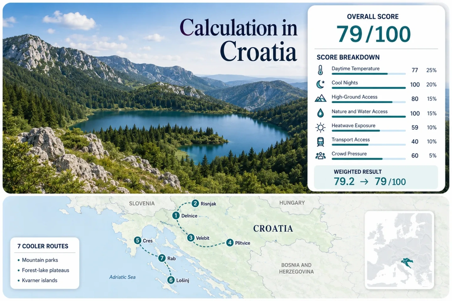
Four highland or park routes and three Kvarner island alternatives are assessed with equal route weighting.
The Zavižan high-ground station records a July–August average daily maximum near 16.2°C in the cited DHMZ normal.
Rail-linked Gorski Kotar settlements provide a practical alternative to park routes that require mountain-road access.
Cres, Lošinj and Rab retain warm days and nights, but coastal airflow and forested peninsulas improve activity planning.
Plitvice uses timed entrance validation, while island travel depends on sailing schedules, vehicle queues and reserved departures.
Official DHMZ station tables are used, but several routes rely on representative stations and legacy normal periods.
From Gorski Kotar to the Kvarner Islands
The route set moves from forested mountain basins and national parks to northern Adriatic islands. This distribution matters: the inland routes depend on altitude and night cooling, while island comfort depends more heavily on breeze exposure, swimming access and shaded terrain.
Markers show selected route regions and approximate planning centres, not guaranteed legal parking, trailheads or exact viewpoints. Use the access notes and Google Maps links in each route card before travelling.
Croatia Cooler Route Suitability Score
This transparent editorial suitability index measures the seven routes shown on the map rather than Croatia as a whole. It uses disclosed climate, landscape, access and pressure factors and is not an official climate classification or a weather forecast.
Weighted total: 77×0.25 + 100×0.20 + 80×0.15 + 100×0.15 + 59×0.10 + 40×0.10 + 60×0.05 = 79.2 → 79/100
Method: Route count does not add bonus points. Each route carries equal weight, and route-level values are combined using the median before the seven fixed factor weights are applied.
Gorski Kotar, Velebit and Kvarner Island Routes
The first four routes provide the clearest temperature reduction. The final three retain the Adriatic character while shifting attention toward northern islands, woodland, ridge walks and less urbanised shorelines.
Delnice–Fužine
Delnice sits at roughly 700 m in the central Gorski Kotar basin, while Fužine adds reservoir paths and a compact accommodation base. The representative Parg station produces a July–August average daily maximum of 21.7°C and an average minimum of 10.5°C in the cited normal.
The same station records approximately 0.6 days at or above 30°C across the two target months. Parg is higher than the main settlements, so its values should be treated as a highland proxy rather than a street-level forecast.
Risnjak National Park
Crni Lug is the principal park-side base for forest walks and approaches toward the 1,528 m Risnjak massif. The route shares the Parg climate proxy with Delnice–Fužine: about 21.7°C by day, 10.5°C at night and a low published 30°C threshold frequency.
Its advantage over Fužine is deeper park immersion; its trade-off is weaker car-light mobility. Trail length, summit exposure and changing mountain weather make early route selection more important than in the compact Gorski Kotar towns.
Northern Velebit and Zavižan
16.2°C average daily maximum and 9.1°C average minimum make the Zavižan station the clearest low-heat signal in the route set. The cited DHMZ normal reports no July or August days averaging into the 30°C threshold-frequency category.
The high ground comes with the portfolio’s weakest transport score. Official park information warns that access roads can be affected by snow in spring and late autumn, and conditions on the mountain approach should be checked even in the nominal visitor season.
Plitvice Lakes and Korenica
The Plitvice–Korenica corridor combines a high Lika accommodation base with continuous forest and lake access. Gospić is used as a representative Lika station, producing a July–August average daily maximum of 24.7°C, a minimum of 10.3°C and about 5.6 threshold days at or above 30°C across the two-month normal.
Temperature relief is less pronounced than at Zavižan or Parg, but night cooling remains strong. The decisive planning issue is the official timed-entry system: tickets must be validated at the selected entrance and within the purchased period.
Cres: Beli and Tramuntana
Northern Cres differs from the island’s more Mediterranean southern sector. Around Beli, Tramuntana woodland creates a shaded island alternative with seven mountain trails, seven walking trails and three cycling trails identified by the local tourism organisation.
The 19 km Porozina–Tramuntana–Beli circuit gives the route measurable depth beyond a beach stay. Climate scoring uses Rijeka as a regional maritime proxy: approximately 27.4°C by day, 18.2°C at night and a 23.7% 30°C threshold-frequency estimate. The proxy has meaningful distance and exposure limitations.
Lošinj: Mali Lošinj and Osoršćica
Mali Lošinj is the only island route with a direct station in the score set. Its July–August station values are warm: 27.8°C average daily maximum, 20.3°C average minimum and roughly 13.9 published 30°C threshold days across the target period.
Cooling therefore comes from route design rather than a cool climate. Osoršćica runs for approximately 20 km along northern Lošinj and reaches 588 m at Televrin, allowing an early-morning ridge option above the resort streets.
The Rijeka–Cres–Mali Lošinj catamaran line takes about 4 hours 30 minutes for its complete route, while road arrivals cross Cres before reaching Lošinj.
Rab: Kalifront and Dundo Forest
Kalifront is Rab’s low, heavily wooded western peninsula. The official Capo Fronte route is 22.5 km, has 363 m of total elevation and is listed at approximately three hours. Dundo’s preserved oak forest provides more shade than Rab’s exposed northern landscapes.
Rijeka is used as a regional maritime climate proxy, giving 27.4°C daytime and 18.2°C night values for scoring. Kalifront itself rises only to about 94 m, so the route offers no meaningful high-ground heat escape.
Valbiska–Lopar takes approximately 80 minutes and the purchased ticket reserves a place on the selected departure. The Rijeka–Rab catamaran takes approximately 1 hour 45 minutes.
When an Adriatic Breeze Does Not Mean a Cool Day
Gorski Kotar Reduces Both Day and Night Heat
Delnice–Fužine and Risnjak share a Parg-based normal near 21.7°C for daytime maxima and 10.5°C for minima. Even after allowing for station-elevation differences, the highland basin offers a materially different sleep and walking environment from the coast.
Kvarner Islands Retain Heat After Sunset
The Mali Lošinj normal remains near 20.3°C for July–August average minima. Rijeka’s representative value is around 18.2°C. Sea breezes can improve perceived comfort, but they do not provide the same overnight reset as Gorski Kotar or Lika.
Forest Determines the Island Alternative
Tramuntana, Osoršćica and Kalifront are included because each permits movement away from dense waterfront streets. Beli’s oak woodland and Rab’s Dundo reserve provide stronger midday fallback options than exposed beaches or bare karst paths.
Ferry Lines Change the Cres, Lošinj and Rab Decision
The islands are not interchangeable once vehicle boarding, onward road time and reserved departures are considered.
Cres Has Two Short Vehicle Gateways
Brestova–Porozina takes about 20 minutes and places arrivals in northern Cres, but Beli still requires a winding local-road transfer. Valbiska–Merag takes about 25 minutes and is more useful for central and southern Cres.
Lošinj Extends the Journey Across Cres
A vehicle arriving on Cres must continue along the island spine and cross at Osor. The direct passenger catamaran avoids driving but has a long multi-stop route. Lošinj suits a multi-night stay more than a rapid heat-escape detour.
Rab Rewards Departure Planning
The Valbiska–Lopar ticket reserves a place on the selected ferry, while the Rijeka catamaran reaches Rab town in about 1 hour 45 minutes. The correct choice depends on whether the route requires a vehicle at Kalifront.
Seven Routes by Heat, Access and Summer Trade-Off
Climate figures are station-based July–August normals or representative proxies, not forecasts for every trail or accommodation property.
| Route | Day / Night Proxy | Main Cooling Mechanism | Car-Light Strength | Peak Pressure | Critical Live Check |
|---|---|---|---|---|---|
| Delnice–Fužine | 21.7°C / 10.5°C | Highland basin, forest and reservoirs | Strongest in the route set | Moderate weekends | Rail and local connection times |
| Risnjak National Park | 21.7°C / 10.5°C | Dense mountain forest and altitude gain | Limited beyond Crni Lug | Generally manageable | Trail, lodge and weather status |
| Northern Velebit and Zavižan | 16.2°C / 9.1°C | High-elevation exposure | Weak | Road and parking concentration | Mountain-road and fog conditions |
| Plitvice Lakes and Korenica | 24.7°C / 10.3°C | Plateau nights, forest and water | Good intercity access | High timed-entry pressure | Ticket entrance and validation period |
| Cres: Beli and Tramuntana | 27.4°C / 18.2°C | Maritime airflow and oak woodland | Ferry plus local transfer | Seasonal ferry pressure | Sailing notices and island-road time |
| Lošinj: Mali Lošinj and Osoršćica | 27.8°C / 20.3°C | Sea access and 588 m ridge | Possible by catamaran | High resort demand | Heat warnings and ridge exposure |
| Rab: Kalifront and Dundo Forest | 27.4°C / 18.2°C | Oak forest, coves and coastal airflow | Possible by catamaran | Ferry and late-July pressure | Reserved departure and event dates |
Plitvice Timed Entry Versus Open Highland Bases
Plitvice Requires a Fixed Arrival Decision
Official tickets are connected to an entrance and validation period. An early slot may reduce heat and visitor concentration, but it also removes flexibility if the overnight base, coach arrival or weather conditions change.
Delnice and Fužine Preserve Daily Flexibility
Gorski Kotar allows a forecast-led choice between reservoirs, forest roads, short town walks and higher outings. This flexibility is valuable during thunderstorms or unstable mountain weather, even though public transport cannot reach every trail.
Highland Hiking and Island Swimming Use Different Windows
Late June
Long daylight supports mountain walks, while high roads and trails generally have a better chance of being snow-free than in spring. Island water may be less warm than in peak summer, but ferry and accommodation pressure is often lower than the central holiday period.
July–August
The sea is most useful for swimming-based cooling, but the island climate values show warm days and nights. Gorski Kotar and Northern Velebit offer the clearest heat reduction, while Plitvice and vehicle ferries require firmer capacity planning.
September
September can align milder air with usable sea temperatures, but shorter daylight and more changeable weather affect mountain plans. Ferry frequency, park hours and high-road conditions should be checked for the exact travel dates.
Checks That Matter Before Leaving the Coast
Mountain route: Check DHMZ warnings, cloud, wind and the current park-road status. Plitvice route: Confirm the selected entrance and ticket validation period. Island route: Recheck the official Jadrolinija sailing notice, whether the ticket reserves a specific departure and the onward road or bus connection. Historical normals describe route tendencies; they do not replace the current forecast or official access notice.