Kosovo for Mountain Summer Escapes: Sharr Valleys, Lakes and Highland Towns
Kosovo’s strongest summer cooling pattern is vertical rather than coastal: roads rise quickly from warm basins toward the Sharr Mountains, the Gora villages and the high lake country of Rugova. Prevalla, Brezovica, Brod and Restelica place overnight bases close to high ground, while Leqinat and Batlava add two very different water-based options. Afternoon heat can still reach mountain valleys, but elevation, forest cover and cooler nights create a practical alternative to staying in the lower cities through July and August.
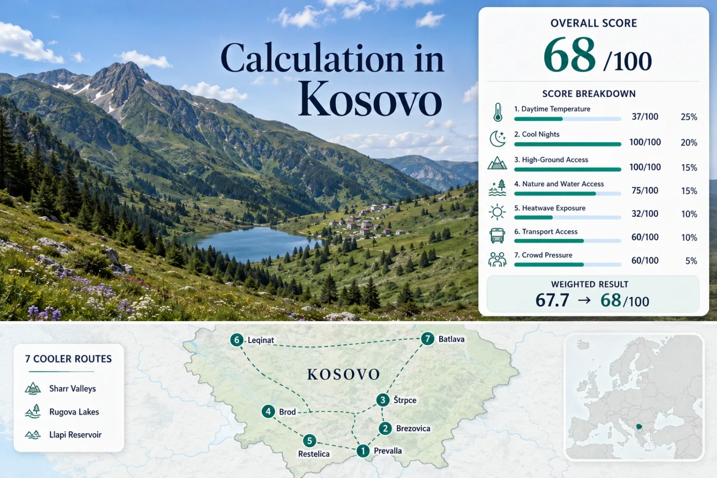
Five Sharr and Gora bases, one Rugova lake route and one forested reservoir corridor.
Peja municipality places the Leqinat lakes near Kuqishtë at about this elevation.
Official nature reporting identifies Livadhi, Jazhinca, Katundi i Epërm and Shutman as high-mountain lakes.
The completed Zhur–Dragash–Brod road is the principal approach for Brod and the wider Gora highlands.
High overnight bases reduce the need to descend to hotter lowland accommodation after hiking.
Town-to-town roads are usable, but trailheads, alpine lakes and remote villages rarely form a simple car-free circuit.
From the Sharr Valleys to Rugova and Batlava
The route set links high overnight bases, alpine-water walks and a lower lake corridor rather than treating Kosovo as one uniform summer climate.
Markers show selected cooler-route regions and planning centers, not guaranteed legal parking, trailheads or exact viewpoints. Use the place-specific Google Maps links and verify local access before traveling.
Kosovo Mountain Summer Escape Suitability Score
This transparent editorial suitability index uses disclosed climate, landscape, access and pressure factors. It is not an official climate classification or a weather forecast. The seven routes carry equal weight inside each factor, and route count does not create a score bonus.
Method: July–August mean daily maximum values were read from official 2008–2017 station comparison figures and rounded to 0.1°C. Published high-mountain station series were unavailable, so nearby lower stations act as conservative representatives.
Raw: Route median 28.8°C; linear interpolation between 27°C = 55 and 29°C = 35 produces 37/100.
Route values: Prevalla Pass 28.8°C; Brezovica and Livadhi Lake 28.8°C; Štrpce Valley 28.8°C; Brod 28.8°C; Restelica 28.8°C; Kuqishtë–Leqinat Lakes 30.3°C; Batlava Lake at Orllan 29.4°C. Median: 28.8°C.
Source mapping: The first five routes use Ferizaj station at 578 m; Kuqishtë–Leqinat uses Peja station at 498 m; Batlava uses Prishtina station at 573 m. Station codes are not published in the cited figures. The mapped mountain bases are generally higher than these stations, so the proxy is warmer than many route microclimates.
Period: July–August means from the official 2008–2017 comparison baseline.
Sources: Kosovo Hydrometeorological Yearbook 2017–2018; HMIK station locations and elevations.
Method: July–August mean daily minimum values use the same official station figures and representative mapping as the daytime factor.
Raw: Route median 14.4°C, inside the 10–16°C full-score band.
Route values: Prevalla Pass 14.4°C; Brezovica and Livadhi Lake 14.4°C; Štrpce Valley 14.4°C; Brod 14.4°C; Restelica 14.4°C; Kuqishtë–Leqinat Lakes 16.0°C; Batlava Lake at Orllan 14.8°C. Median: 14.4°C.
Source mapping: Ferizaj represents the Sharr and Gora routes, Peja represents Rugova, and Prishtina represents Batlava. Large positive route-to-station elevation differences strengthen rather than weaken the expectation of overnight relief, but no unverified lapse-rate adjustment is added.
Period: July–August means from the official 2008–2017 comparison baseline.
Sources: Official station temperature comparison figures; Official station metadata.
Method: Categorical rubric based on lodging elevation or regular access to ground above 1,500 m within about one hour.
Raw: Median route score 100/100.
Route scores: Prevalla Pass 100 — overnight base on a high Sharr road; Brezovica and Livadhi Lake 100 — official Brezovica station elevation 915 m with much higher resort terrain; Štrpce Valley 100 — high ground rises directly south of town; Brod 100 — high village beneath Gora ridges; Restelica 100 — high southern Sharr base; Kuqishtë–Leqinat Lakes 100 — municipal source places the lakes at about 1,860 m; Batlava Lake at Orllan 80 — lake base with nearby uplands. Median: 100/100.
Route rationale: The score measures practical vertical access, not summit difficulty or scenic quality.
Period: Access and geography reviewed July 2026.
Sources: HMIK meteorological station table; Peja Municipality Rugova profile; Official Sharr National Park spatial plan decision.
Method: Categorical rubric measuring physical access to broad forest, significant lake or river systems within 30–60 minutes.
Raw: Median route score 75/100.
Route scores: Prevalla Pass 75 — extensive forest and the upper Lumbardhi catchment; Brezovica and Livadhi Lake 100 — forest plus an alpine-lake objective; Štrpce Valley 75 — Lepenac valley and forested slopes; Brod 75 — Brod river valley and high pasture; Restelica 75 — Restelica river system and mountain pasture; Kuqishtë–Leqinat Lakes 100 — forest approach plus two high lakes; Batlava Lake at Orllan 100 — large reservoir and surrounding woodland. Median: 75/100.
Route rationale: Alpine lakes that require a hike count as route-access features, while Batlava supplies direct shoreline time but less elevation.
Period: Geography and access reviewed July 2026.
Sources: Official State of Nature report; Peja Municipality on Rugova and Leqinat; Official Kosovo water report.
Method: Official threshold-frequency fallback using published station counts of days with maximum temperature at or above 30°C. The source tables provide July and August counts for 2014; no unsupported ten-summer count is claimed.
Raw: Median representative-station rate 17.7%; interpolation between 10% = 55 and 20% = 25 produces 32/100.
Route values: Prevalla Pass 11/62 days, 17.7%; Brezovica and Livadhi Lake 11/62, 17.7%; Štrpce Valley 11/62, 17.7%; Brod 11/62, 17.7%; Restelica 11/62, 17.7%; Kuqishtë–Leqinat Lakes 30/62, 48.4%; Batlava Lake at Orllan 17/62, 27.4%. Median: 17.7%.
Source mapping: Ferizaj supplies the threshold fallback for the five Sharr and Gora routes, Peja for Rugova and Prishtina for Batlava. All three are lower than the principal mountain objectives, so the result should be read as a conservative exposure screen.
Period: July–August 2014; 62 valid days out of 62 expected days per station table. The yearbook reports complete daily maximum and minimum temperature recording for these stations.
Sources: Kosovo Hydrometeorological Yearbook 2014 threshold tables.
Method: Categorical rubric based on paved-road approach, connection complexity and the need for a private vehicle beyond the principal town.
Raw: Median route score 60/100.
Route scores: Prevalla Pass 60 — direct regional-road approach but local movement is car-oriented; Brezovica and Livadhi Lake 60 — paved approach with trailhead dependence; Štrpce Valley 80 — service town on the regional corridor; Brod 40 — long southern approach with limited onward flexibility; Restelica 40 — remote final-road segment from Dragash; Kuqishtë–Leqinat Lakes 40 — road access into Rugova followed by trailhead logistics; Batlava Lake at Orllan 60 — straightforward road approach from the Prishtina–Podujevë side. Median: 60/100.
Route rationale: No regular summer lift, shuttle or village bus frequency is assumed unless confirmed for the travel date.
Period: Road and access status reviewed July 2026.
Sources: Official Zhur–Dragash–Brod road announcement; Sharr National Park spatial plan; Peja Municipality Rugova access context.
Method: Categorical fallback using official identification of heavily frequented tourism areas, visitor-management signals and the absence of route-level accommodation occupancy data.
Raw: Median route score 60/100.
Route scores: Prevalla Pass 40 — officially identified as one of the most popular Sharr tourism areas; Brezovica and Livadhi Lake 40 — the other principal high-use Sharr center; Štrpce Valley 80 — services without the same concentrated day-use pattern; Brod 80 — smaller and dispersed lodging base; Restelica 80 — remote village with limited mass-visitor infrastructure; Kuqishtë–Leqinat Lakes 60 — increasing recreation use and trailhead concentration; Batlava Lake at Orllan 60 — summer shoreline pressure without a route-level reservation system. Median: 60/100.
Route rationale: The factor measures planning pressure, not destination popularity as a quality signal.
Period: Official nature reporting, 2024 national hotel statistics and park-management notices reviewed July 2026.
Sources: Official nature report on Prevalla and Brezovica use; Kosovo Agency of Statistics tourism data for 2024; Sharr National Park visitor-area monitoring notice.
Sharr Passes, Gora Villages and Two Lake Corridors
The seven bases serve different heat-escape needs: high-road overnight stays, service-town access, remote village nights, alpine-lake walking and direct shoreline time.
Prevalla Pass
Prevalla places accommodation on the road crossing the Sharr Mountains between Prizren and Štrpce. The official nature record treats it as a major tourism area, while the upper Lumbardhi catchment and adjacent forest create a stronger cooling setting than the Prizren basin.
Decision data: Representative climate proxy 28.8°C daytime and 14.4°C night-time for July–August; high-ground score 100/100; crowd-pressure score 40/100. The station proxy comes from lower Ferizaj and is intentionally conservative.
Brezovica and Livadhi Lake
The Brezovica station is listed at 915 m in the official meteorological network, and the resort terrain rises far above the village. Livadhi Lake adds a high-water objective, but it is a mountain walk rather than a drive-up swimming stop.
Do not build a summer plan around lift operation unless the operator confirms it for the date. Road access and walking remain the dependable structure.
Štrpce Valley
Štrpce is the practical services base of the eastern Sharr route. It sits between Ferizaj and the Prevalla–Prizren road, making it easier to combine grocery, fuel and lodging needs with higher day trips than in Brod or Restelica.
Good for: Travelers who want a mountain town base rather than an isolated resort road.
Brod
Brod shifts the trip from a resort corridor to the Gora highlands. The official road announcement confirms the 42 km Zhur–Dragash–Brod route, giving the village a clearer paved approach than older travel accounts suggest.
Route measures: High-ground score 100/100; transport score 40/100; crowd-pressure score 80/100; representative July–August night value 14.4°C. The official Dragash station is listed at 1,060 m, but the historical yearbook states that its data were unavailable, so Ferizaj is used for the score.
Restelica
Restelica is the most remote overnight base in the set. The village belongs to the southern Sharr river system identified in official nature reporting and sits beyond Dragash, where a short urban-style itinerary becomes unrealistic.
The payoff is a high overnight position, low concentrated tourism pressure and immediate access to mountain pasture. The trade-off is 40/100 transport accessibility: food, fuel and route changes should be settled before the final approach.
Kuqishtë–Leqinat Lakes
Rugova supplies the route portfolio’s clearest high-lake target. Peja municipality places the Leqinat lakes near Kuqishtë at roughly 1,860 m, with peaks above 2,000 m and a road approach through Rugova Gorge before the walking stage begins.
The Peja station proxy is notably warmer than the lake zone: 30.3°C daytime and 16.0°C night-time for the score baseline. Treat those figures as a lower-valley exposure screen, not a lake-shore forecast.
Batlava Lake at Orllan
Batlava is the route for direct water access rather than alpine walking. The reservoir lies near Orllan in the Llapi region and pairs a broad water surface with surrounding woodland, but its lower setting gives it less protection from hot afternoons than Prevalla, Brod or Leqinat.
Decision data: Representative July–August proxy 29.4°C daytime and 14.8°C night-time; forest/lake score 100/100; high-ground score 80/100; transport score 60/100.
Which Kosovo Highland Route Fits the Summer Plan?
The climate column uses the disclosed representative-station values, while the remaining fields separate overnight elevation, water access and road dependence.
| Route | July–August proxy | Primary cooling asset | Access pattern | Lower-heat strategy | Main constraint |
|---|---|---|---|---|---|
| Prevalla Pass | 28.8°C day / 14.4°C night | High road and forest | Regional road; car-oriented locally | Sleep on the pass, not in Prizren | Weekend concentration |
| Brezovica and Livadhi Lake | 28.8°C / 14.4°C | High resort terrain and alpine lake | Paved approach plus walking | Start lake walks early | Do not assume lift operation |
| Štrpce Valley | 28.8°C / 14.4°C | Valley nights with nearby high slopes | Service-town road corridor | Use town for supplies and day climbs | Warm valley afternoons remain possible |
| Brod | 28.8°C / 14.4°C | High village and Gora ridges | Long paved approach via Dragash | Stay multiple nights | Limited spontaneous route changes |
| Restelica | 28.8°C / 14.4°C | Remote high-village position | Final road beyond Dragash | Arrive supplied and remain overnight | Remote logistics |
| Kuqishtë–Leqinat Lakes | 30.3°C / 16.0°C valley proxy | Lakes near 1,860 m | Rugova road plus mountain trail | Leave the Peja basin early | Trailhead and weather exposure |
| Batlava Lake at Orllan | 29.4°C / 14.8°C | Reservoir and forest shade | Road-accessible shoreline corridor | Use morning and late-afternoon water time | Less altitude protection |
Brod and Restelica Depend on the Dragash Road Spine
The 42 km Zhur–Dragash–Brod Link
The completed road improves the southern approach, but it does not turn Brod into a quick side trip. A mountain escape works better when Brod is the overnight destination, with Prizren used before or after the highland stay rather than as a daily return base.
Restelica Adds a Second Logistics Layer
Restelica lies beyond the Dragash service center. Fuel, cash, food and mobile coverage expectations should be settled before the final segment. The remoteness is part of the cooling advantage, because it supports a higher, quieter overnight rhythm.
Mountain Roads Are Not Automatic Border Crossings
Road construction toward North Macedonia has been discussed officially, but a visible road on a map does not establish an open international crossing. Cross-border itineraries should use currently authorized checkpoints and official entry rules.
Leqinat, Livadhi and Batlava Serve Different Summer Needs
Leqinat Is a High Walking Day
The route gains cooling through elevation, not immediate roadside water. The lake objective near 1,860 m requires a mountain approach, changing footwear, weather and turnaround-time decisions.
Livadhi Extends a Brezovica Stay
Livadhi works as a high-water extension to a Brezovica base. It should not be treated as a substitute for a managed bathing lake, and summer lift availability should never be assumed.
Batlava Prioritizes Shore Time
Batlava removes the long alpine walk and gives easier access to water and forest. The trade-off is lower elevation and a greater need to schedule activity around hot midday conditions.
Prevalla and Brezovica Need a Different Weekend Strategy
The official nature record identifies Prevalla and Brezovica as the Sharr’s most popular tourism areas, with visitor-management and development concerns concentrated there. Their road access makes them easy to reach, but that same advantage can weaken the quiet, cool-air experience on busy summer weekends.
Use Weekdays for the Main High-Road Stay
Arriving before Friday evening reduces the chance of building a trip around congested roadside stops. It also leaves more flexibility for an early Livadhi or upper-forest start.
Food Waste Has a Wildlife Consequence
Sharr park authorities increased monitoring in Brezovica and Prevalla after brown bears approached visitor and residential zones, particularly where food waste was available. Food should remain secured, and all waste should leave the mountain area.
Final Checks for a Kosovo Mountain Summer
Confirm the current mountain forecast, road works, park notices and trail conditions shortly before departure. Afternoon thunderstorms, open-area fire risk and rapid visibility changes matter more on the high Sharr and Rugova routes than in the lower towns. Carry water even when the destination is a lake, and do not rely on seasonal lifts, informal shortcuts or an unverified border road.