Coolcations in Slovenia: Alpine Lakes, Green Valleys and Karst Breezes
Slovenia compresses several summer comfort systems into a small area: glacial lakes beneath the Julian Alps, shaded river valleys, forest basins and wind-exposed karst plateaus. July and August can still produce hot spells, yet the route set here keeps higher ground, water, forest cover or cave-cooled relief within reach instead of treating the country as one uniform climate zone.
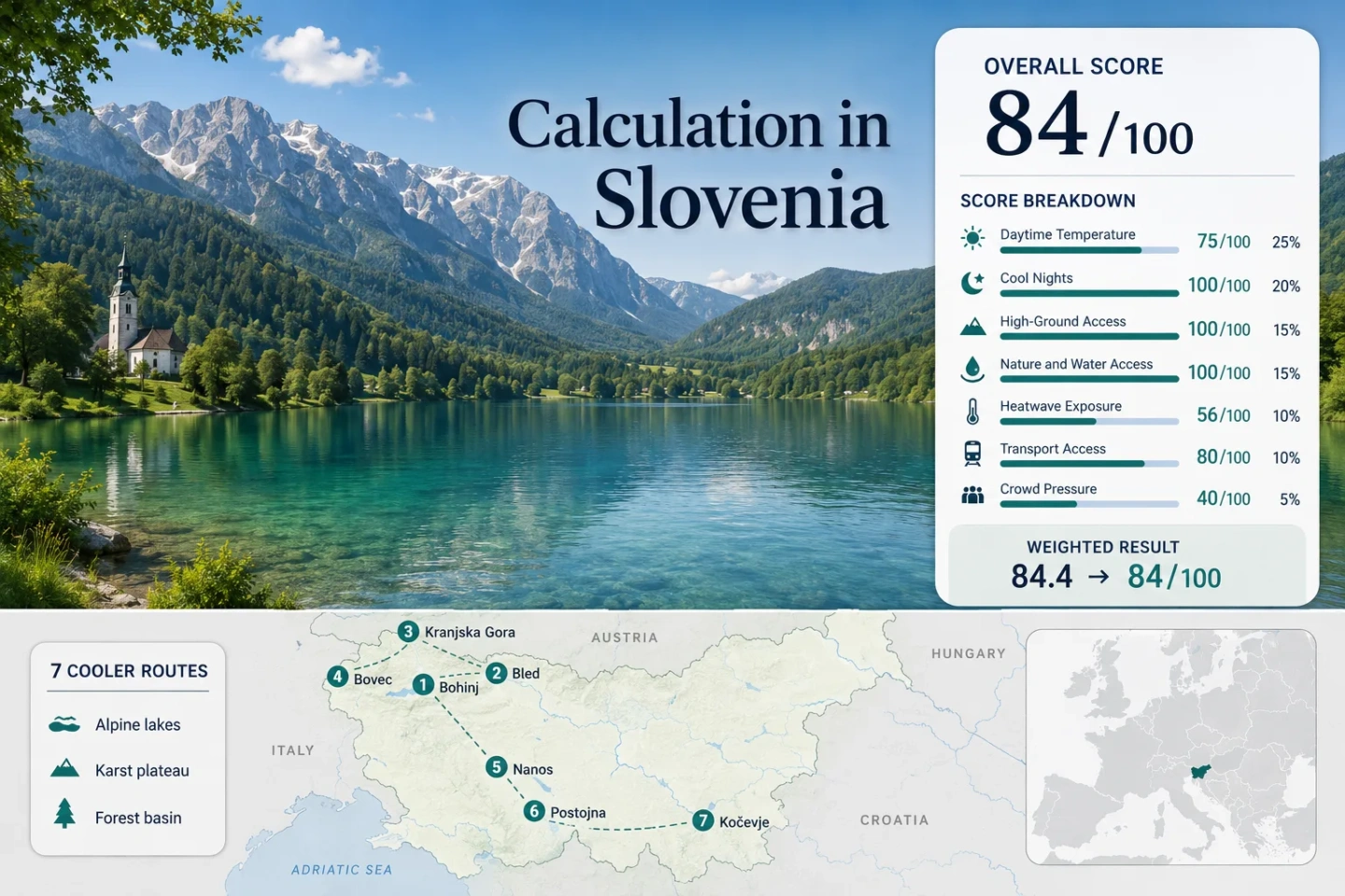
Three Alpine routes, one Soča Valley base, two karst options and one forest basin form the shared map, score and comparison set.
The July–August mean daily maximum at the ARSO Nanos–Abram station is lower than the route-set median of 25.1°C.
Rateče normals give the clearest overnight release from daytime warmth among the assessed Alpine bases.
The cave operator reports a constant interior temperature, creating a weather-independent contrast with warm karst afternoons.
Bohinj, Bled and the Vršič corridor work more smoothly when rail, seasonal buses and park-and-ride options replace midday driving.
Values use July–August official 1981–2010 station normals and disclosed representative-station mappings.
From Julian Alps Lakes to the Nanos and Kočevje Ridges
The markers follow the exact seven-route portfolio used in the suitability score. Alpine options cluster in the northwest; Postojna and Nanos provide karst alternatives, while Kočevje shifts the emphasis toward forest shade and cooler nights.
Markers show selected route centers for planning orientation, not guaranteed legal parking, trailheads or exact viewpoints. Use the named Google Maps links and current local access information before traveling.
Slovenia Alpine, Valley and Karst Suitability Score
This transparent editorial suitability index uses disclosed climate, landscape, access and pressure factors. It is not an official climate classification or a weather forecast.
Weighted total: 75×0.25 + 100×0.20 + 100×0.15 + 100×0.15 + 56×0.10 + 80×0.10 + 40×0.05 = 84.4 → 84/100
Method: Route count adds no bonus. Each route carries equal weight; route-level values are combined with the median before the fixed factor weights are applied.
Alpine Lakes, Soča Water and Karst High Ground
The routes differ more in access rhythm and afternoon exposure than their short map distances suggest. Each card combines climate-normal values with elevation, public-transport and peak-pressure information.
Lake Bohinj and Upper Bohinj Valley
Glacial water, deep forest and immediate mountain walls make Bohinj the most balanced water-and-altitude base in the route set. Bohinjska Češnjica normals place July–August daytime maxima near 25.1°C and nights near 12.1°C, while the lake sits around 526 m and higher trailheads rise quickly beyond the basin.
Main caution: Parking is restricted to designated areas, and summer shuttles are part of the normal access plan rather than an optional extra on busy days.
Lake Bohinj and Upper Bohinj Valley on Google MapsLake Bled and Radovljica Basin
Bled trades some cool-air purity for easier services and transport. Lesce station normals give a July–August pattern of about 25.1°C by day and 13.3°C at night. The lake, Vintgar Gorge and nearby wooded slopes provide varied short outings, but the compact shore concentrates traffic and visitors.
Car-light travel is unusually practical here: two rail approaches, regular buses and summer local transport reduce the need to search for central parking.
Kranjska Gora and Lake Jasna
Rateče, at 864 m, records the coolest route-set combination: roughly 23.5°C daytime maxima and 10.4°C nights across July and August. Kranjska Gora adds Lake Jasna, forested side valleys and direct road access toward the 1,611 m Vršič Pass.
The pass is a transport asset and a planning risk at the same time; weather, roadworks, parking controls and weekend traffic can change the usable high-ground window.
Kranjska Gora and Lake Jasna on Google MapsBovec and Upper Soča Valley
Bovec sits near 452 m, with official daytime normals averaging about 25.8°C in July–August. The route works because the Soča river corridor, forested tributary valleys and high-pass roads allow rapid shifts in elevation and exposure, not because the town is immune to hot afternoons.
Seasonal Bovec shuttles and the 2026 free Vršič bus widen the car-light options, although long-distance arrival remains less direct than Bled or Postojna.
Nanos Plateau and Razdrto
The Nanos–Abram station stands at 905 m and records July–August mean daily maxima of 22.5°C with nights near 11.7°C. That makes the plateau the clearest low-heat route by official normal, but it is a hiking and driving proposition rather than a full-service lake town.
Watch for: Exposed ridges can be windy, cloud can reduce visibility, and shade is less continuous than in Bohinj or Kočevje.
Nanos Plateau and Razdrto on Google MapsPostojna Karst and Cave Park
Postojna’s 533 m station has July–August daytime maxima around 25.4°C and nights around 12.5°C. The unusual advantage is a constant 10°C cave interior, which creates a reliable cool interval even when the surface is warm, wet or stormy.
Timed cave visits and warm clothing matter: the underground environment is far cooler than the outdoor forecast, and entry times can become the day’s fixed point.
Kočevje Forest Basin and Lake
Kočevje is the warmest daytime route by a narrow margin at about 25.9°C, yet its 12.0°C night normal, large forest system and town lake create a different comfort profile from exposed lowland cities. It is more useful for shade, quiet nights and lower booking pressure than for the lowest afternoon temperature.
Bled–Bohinj Mobility Split: Rail Bases, Shuttles and Shore Pressure
The two lakes are close on the map but reward different transport choices. Bled has the stronger immediate service network; Bohinj has the broader mountain-water setting but relies more heavily on seasonal movement systems.
Bled Works as the Car-Light Lake Base
Lesce–Bled station, Bled Jezero station, regular buses and the summer Bled Bus create several ways to reach the shore without central parking. That advantage matters because official parking rules concentrate vehicles in designated areas and high-season rates rise near the lake.
Bohinj Uses a Wider Seasonal Shuttle Network
Bohinjska Bistrica acts as the rail gateway, while summer transport continues toward Lake Bohinj, Ukanc, Pokljuka and mountain-pasture access points. A lake stay is therefore easier when accommodation and shuttle stops are planned together rather than treated as separate decisions.
Early Starts Change Both Lakes
At Bled, an early arrival reduces parking friction and shore congestion. At Bohinj, it also protects access to trailhead shuttles and gives more time before Alpine convection builds. The same clock time solves different problems at each lake.
Vršič Connects Kranjska Gora and Bovec, but the Pass Sets the Pace
The Vršič road joins two of the strongest Alpine routes across a 1,611 m pass. For the 2026 tourist season, the official Soča Valley notice states that a free bus operates between Kranjska Gora and Bovec from June 1 to September 30, with increased frequency from June 26 to August 31. That creates a useful cross-Alps option without requiring every traveler to drive or park at the summit.
Kranjska Gora Favors a Morning Ascent
Cooler Rateče nights support early departures, and Lake Jasna provides a low-effort alternative when pass cloud or traffic makes a summit plan unattractive.
Bovec Keeps River-Valley Options Open
The Soča corridor offers lower-level water access, while seasonal shuttles extend toward high roads and trailheads. This flexibility is valuable when the pass is busy but the valley forecast remains workable.
The Pass Requires a Live Check
Roadworks, parking controls, storms and traffic can override a climate-normal plan. Check PROMET.SI road conditions and the current bus timetable on the travel day.
Nanos Breezes and Postojna Cave Air Solve Different Heat Problems
Nanos Lowers the Outdoor Temperature
At 905 m, the Nanos–Abram station has the lowest daytime normal in the route set. The trade-off is exposure: plateau wind, cloud and limited shelter can make conditions change faster than at a lake or forest base.
Postojna Creates a Fixed Underground Interval
The cave’s reported 10°C interior is not a surface-climate claim. It is a controlled underground contrast that works during hot, rainy or stormy periods, provided the timed entry and clothing difference are built into the schedule.
A Two-Base Karst Plan Separates Weather Risk
Postojna is the rail-friendly base with services and a fixed cave visit. Razdrto and Nanos suit a forecast-led hiking day. Keeping them separate avoids forcing an exposed plateau hike into poor visibility or treating a cave ticket as a spontaneous stop.
Seven Routes by Heat, Access and Peak Pressure
The climate figures are station normals rather than forecasts. Access and pressure columns identify the planning trade-off that most often changes the practical value of each route.
| Route | July–August day / night | Car-light access | High-ground option | Peak pressure | Main weather trade-off |
|---|---|---|---|---|---|
| Lake Bohinj and Upper Bohinj Valley | 25.1°C / 12.1°C | Rail gateway plus seasonal buses | Vogel and Julian Alps trailheads | High around lake parking | Afternoon storms and wet mountain days |
| Lake Bled and Radovljica Basin | 25.1°C / 13.3°C | Strong rail and bus network | Pokljuka and Karavanke approaches | Very high near the lake | Warmer basin afternoons and concentrated crowds |
| Kranjska Gora and Lake Jasna | 23.5°C / 10.4°C | Regular bus, no direct railway | Vršič Pass and side valleys | High on pass and event weekends | Rapid mountain weather changes |
| Bovec and Upper Soča Valley | 25.8°C / 13.9°C representative night value | Bus plus seasonal shuttles | Vršič, Predel and high trailheads | High at major access points | Heavy showers and pass dependence |
| Nanos Plateau and Razdrto | 22.5°C / 11.7°C | Car-oriented trail access | Route already occupies high ground | Moderate weekend trailhead pressure | Wind, cloud and exposed ridges |
| Postojna Karst and Cave Park | 25.4°C / 12.5°C; cave 10°C | Direct rail and bus | Nanos as a separate excursion | Timed-entry pressure | Large indoor–outdoor temperature contrast |
| Kočevje Forest Basin and Lake | 25.9°C / 12.0°C | Rail to town; onward planning needed | Wooded ridges within the region | Lower broad pressure | Warm afternoons despite shaded landscapes |