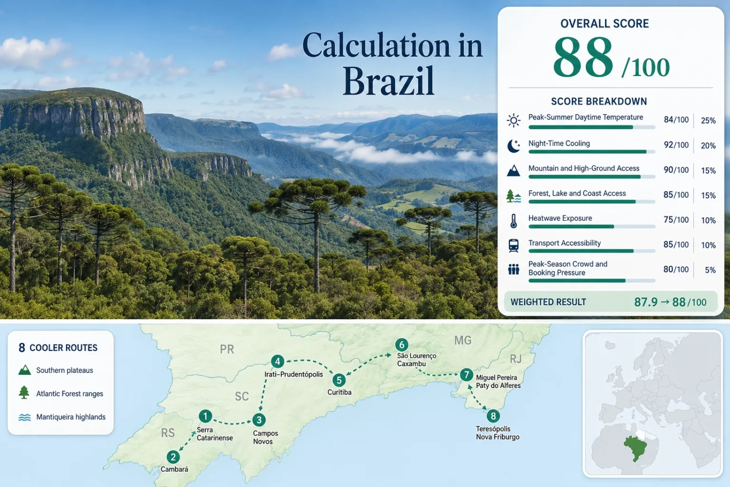
Brazil Cooler Routes: Southern Plateaus, Mountain Towns and Atlantic Forest Air
Brazil’s most dependable peak-summer relief is concentrated in elevated parts of the South and Southeast, but the cooling mechanisms are not interchangeable. Open plateaus lose heat efficiently after sunset, Mantiqueira towns trade lower temperatures for longer road access, and Atlantic Forest corridors provide shade while sometimes holding enough humidity to weaken night-time relief. The January–February route set therefore favors places where elevation, usable green space and practical access overlap, rather than treating every winter-branded town as a reliable summer refuge.
The same eight names are used in the map, score evidence, route profiles and comparison matrix.
The comparison addresses Brazil’s Southern Hemisphere peak-summer period, not the colder June–August tourism season.
Median January–February daily maximum and minimum from the disclosed INMET station set.
Bom Jesus, the Serra Catarinense and Campos Novos retain the clearest overnight cooling signal.
Both offer urban services and regular public transport before mountain or forest access is added.
High ground lowers typical temperatures but does not remove humid afternoons, convective storms or short hot spells.
From Southern Plateaus to the Atlantic Forest Ranges
The route footprint runs from Santa Catarina and Rio Grande do Sul plateaus through Paraná’s araucaria belt, then reaches the Mantiqueira and Serra do Mar mountain systems in Minas Gerais and Rio de Janeiro.
This marker map is built for planning orientation. Markers show selected route regions and approximate public centers, not guaranteed legal parking, trailheads or exact viewpoints. Use the named Google Maps links and current access rules before traveling.
Brazil Plateau and Mountain-Town Cooler Escape Suitability Score
This transparent editorial suitability index uses disclosed climate, high-ground, landscape-access, transport and pressure factors. It is not an official climate classification or a weather forecast. The score applies only to the eight route clusters shown here, not to Brazil as a whole.
Weighted total: 53×0.25 + 90×0.20 + 90×0.15 + 100×0.15 + 29×0.10 + 60×0.10 + 60×0.05 = 71.7 → 72/100
Method: Route count adds no bonus. Each route has equal weight, route medians are calculated before the seven fixed factor weights are applied, and humidity or rainfall is not added as an eighth factor.
Plateaus, Mountain Towns and Forest-Edge Bases
The eight clusters separate strong night-cooling plateaus from more accessible but warmer Southeast mountain towns. Climate figures are station normals, not live forecasts, and representative stations can be warmer or lower than the highest lodging zones.
Serra Catarinense High Plateau
Urubici, Urupema, São Joaquim and Bom Jardim da Serra form the most convincing high-plateau cluster in the portfolio. The disclosed climate proxy is Lages, whose January–February normal is 26.7°C by day and 16.35°C at night. Because much of the route core is higher than the station, the value is intentionally conservative rather than adjusted with an invented lapse-rate correction.
The Lages threshold table averages 7 days at or above 30°C across the 59-day target window. Open grasslands and high ridges often cool faster after sunset than sheltered valleys, while exposed midday stops can still feel hot under clear sun.
Cambará and Campos de Cima da Serra
Bom Jesus station 83919 gives this plateau-and-canyon cluster the coolest disclosed climate values: a 25.5°C January–February mean maximum, a 14.9°C mean minimum and only 3 normal days at or above 30°C across the target window.
Cambará do Sul, São José dos Ausentes and the surrounding plateau work because cool nights, open wind exposure and Atlantic Forest protected areas occur close together. The trade-off is access: the Serra Geral park gate is reached by a 22 km unpaved approach from Cambará, and food is not available inside the park.
Campos Novos Central Plateau
Campos Novos, Curitibanos and Fraiburgo provide a quieter central-plateau alternative to the better-known canyon rim. Direct INMET station 83887 records 26.5°C mean daytime maximum, 16.55°C mean minimum and 4 normal 30°C-plus days in January–February.
The route is less dependent on a single park gate, which distributes visitors and makes it easier to change plans after a wet forecast. Reservoir margins, araucaria fragments and agricultural plateau roads create multiple day patterns, though nature stops remain easier with a car.
The practical advantage is not dramatic scenery at every turn; it is the ability to keep moving between several elevated bases without dropping to a hot coastal plain.
Irati–Prudentópolis Waterfall Plateau
The Irati station mapping produces a 27.35°C mean maximum and 17.2°C mean minimum, with 11 normal days at or above 30°C during January–February. Those figures are warmer than the southern high-plateau leaders, but the route compensates with araucaria forest, deep river valleys and dispersed waterfall access.
Prudentópolis is not a compact waterfall park. The municipal 120 km Caminho de São Miguel Arcanjo and the wider rural road network show why local movement matters: long distances separate town services, churches, mirantes and river sites.
Curitiba and the Serra do Mar Edge
Curitiba station 83842 records a January–February mean maximum of 27.15°C and mean minimum of 17.7°C. The normal threshold count is 11 days at or above 30°C, so the city should not be presented as heat-proof.
Its advantage is logistical resilience. Parks, lakes, shaded streets and public transport remain usable when mountain cloud or rain makes an eastern-range day trip unattractive. São Luiz do Purunã, the Serra do Mar rail corridor and metropolitan forest areas can then be added selectively rather than carrying the whole itinerary.
Works for: Travelers who value a full-service base and several low-commitment green-space options more than the lowest possible afternoon temperature.
São Lourenço–Caxambu Mantiqueira Circuit
São Lourenço station 83736 gives the circuit a 29.2°C mean maximum, 17.5°C mean minimum and 28 normal days at or above 30°C across January and February. The nights are still useful, but daytime relief is less reliable than the phrase “mountain town” may imply.
Caxambu, São Lourenço and Passa Quatro combine mineral-water parks, tree cover and access toward higher Mantiqueira terrain. Intercity buses reach the main towns, while a car improves movement between spa centers, trail approaches and less central lodging.
Miguel Pereira–Paty do Alferes Ridge
The Avelar station is direct to the route cluster and records 30.8°C mean daytime maximum, 19.2°C mean minimum and 41 normal 30°C-plus days in the 59-day target period. This is a ridge-and-rural-air option, not a low-temperature leader.
Paty do Alferes lies 118 km from Rio and its official tourism inventory includes roughly 20 cycling routes, APA Palmares, Lago de Palmares and the Caminho do Imperador. Those assets spread daytime activity beyond a single town center, but exposed rural roads can be hot in early afternoon.
Teresópolis–Nova Friburgo Mountain Corridor
Teresópolis station 83744 records a 28.45°C January–February mean maximum, a 19.05°C mean minimum and 23 normal days at or above 30°C. The corridor’s climate advantage is therefore relative to the Rio lowlands, not equivalent to the colder southern plateaus.
Regular buses connect Rio directly with Teresópolis, and the Serra dos Órgãos headquarters sits beside the urban approach. Deeper mountain activities require more planning: some sectors have numerical limits, risk forms or advance scheduling, and the Petrópolis access includes rougher final road sections.
Choose the corridor for accessible mountain air, forest immersion and flexible town services; choose the southern plateau routes when cool nights are the primary objective.
How the Eight Routes Trade Heat for Access
A lower station maximum does not automatically produce the easiest trip. The comparison keeps the full route portfolio visible and separates climate, mobility and the main comfort limitation.
| Route | Jan–Feb Max | Jan–Feb Min | Normal 30°C+ Days | Mobility Pattern | Main Trade-Off |
|---|---|---|---|---|---|
| Serra Catarinense High Plateau | 26.7°C | 16.35°C | 7 of 59 | Car strongly preferred | Dispersed towns and rapid weather changes |
| Cambará and Campos de Cima da Serra | 25.5°C | 14.9°C | 3 of 59 | Car required for key natural areas | Fog, unpaved park approach and limited services |
| Campos Novos Central Plateau | 26.5°C | 16.55°C | 4 of 59 | Road and coach base; car useful locally | Less concentrated visitor infrastructure |
| Irati–Prudentópolis Waterfall Plateau | 27.35°C | 17.2°C | 11 of 59 | Coach to towns; car for waterfalls | Long rural distances and humid valleys |
| Curitiba and the Serra do Mar Edge | 27.15°C | 17.7°C | 11 of 59 | Strong car-light city base | Short hot spells and wet mountain days |
| São Lourenço–Caxambu Mantiqueira Circuit | 29.2°C | 17.5°C | 28 of 59 | Intercity buses plus optional car | Warm afternoons despite useful nights |
| Miguel Pereira–Paty do Alferes Ridge | 30.8°C | 19.2°C | 41 of 59 | Simple road approach; rural car use | Frequent 30°C days and holiday compression |
| Teresópolis–Nova Friburgo Mountain Corridor | 28.45°C | 19.05°C | 23 of 59 | Direct bus to Teresópolis | Humidity, storms and capacity rules |
Three Different Cooling Systems Shape the Portfolio
Southern Plateau Cooling
Serra Catarinense, Campos de Cima da Serra and Campos Novos rely on southern latitude, open plateau exposure and efficient night-time heat loss. The strongest evidence appears in the 14.9–16.55°C route minimum range, not in permanently cold afternoons.
Mantiqueira Elevation with Warm-Valley Leakage
The Minas Gerais circuit gains useful nights and access to higher terrain, yet lower spa towns can warm quickly. Moving lodging uphill changes comfort more than adding another low-valley water attraction.
Atlantic Forest Shade and Humidity
Serra do Mar and Serra dos Órgãos routes offer dense shade, streams and cloud interception. Those same features can restrict overnight cooling when humid air, sheltered valleys and warm minimums occur together.
When Atlantic Forest Air Stops Feeling Cool
Shade Lowers Radiant Heat, Not Always Air Temperature
A forest trail can feel substantially easier than an exposed town square because the canopy blocks direct solar load. The station temperature may remain similar, so the benefit is strongest during walking hours rather than as a route-wide climate claim.
River Valleys Can Hold Humid Night Air
Prudentópolis waterfall valleys, Mantiqueira spa basins and sheltered Rio de Janeiro slopes can retain moisture after afternoon rain. A room with cross-ventilation at a higher, breezier site may sleep cooler than a lower lodge beside water.
Ridges Trade Shelter for Wind
Canyon rims and high roads can provide immediate airflow, but cloud, mist and crosswinds also reduce visibility and outdoor comfort. Wind exposure is a route advantage only when access remains safe.
Town Centers Store More Heat Than Rural Lodging
Curitiba, Teresópolis and the larger spa towns retain more evening heat around paved commercial centers. The climate normal describes a station environment; it cannot replace a check of lodging elevation, tree cover and ventilation.
Serra Geral Dirt Roads and Serra dos Órgãos Access Rules
The two major protected-area corridors impose different planning constraints, and neither should be treated as a simple extension of the nearest town street network.
Cambará’s 22 km Final Approach Changes the Day
The Serra Geral park gate is 22 km from Cambará do Sul on an unpaved road. Current public information lists Tuesday–Sunday opening from 08:00 to 17:00 and no restaurant or snack bar inside the park. Water, food, rain protection and slower driving time belong in the same calculation as temperature.
Teresópolis Is Easy to Reach; Deeper Mountain Use Is Regulated
Regular buses connect Rio with Teresópolis and the park headquarters sits at the city approach. Higher-demand mountain sectors add forms, limits or advance scheduling: the one-day Travessia sector allows up to 120 people, while the Dedo de Deus complex requires prior scheduling.
December Build-Up, January Storms and February Holiday Pressure
Early December
School-holiday pressure has not fully peaked, but convective rain is already part of the Southern and Southeastern pattern. Plateau loops offer more route substitution than single-viewpoint trips.
January
The lowest-heat strategy favors Bom Jesus, Serra Catarinense and Campos Novos. Waterfall routes gain strong flow and green cover, with a larger wet-road trade-off.
February
Warm spells remain possible across every route. Carnaval can sharply raise lodging pressure in Miguel Pereira, Teresópolis and other Rio mountain towns even when ordinary weekdays are calmer.
Early March
Holiday pressure often eases before the wet-season signal disappears. It can be a practical compromise for forest access, provided road and thunderstorm checks remain part of daily planning.
When a Brazilian Cooler Route Can Still Feel Hot
High Ground Does Not Guarantee a Cool Afternoon
Direct sun on open grassland, pavement or canyon roads can raise heat load even when the air temperature is lower than in the coastal lowlands. The clearest plateau advantage often arrives after sunset.
A Waterfall Cools a Site, Not an Entire Municipality
Spray, shade and cold water provide local relief. They do not lower the temperature of the lodging district, and steep access can add exertion during the warmest hours.
A Winter-Branded Town May Have Frequent 30°C Days
São Lourenço, Avelar and Teresópolis show why June–August reputation cannot substitute for January–February threshold data. Summer suitability must be tested in the summer window.