New Zealand Coolcation Routes: Alpine Towns, Lakes and Southern Hemisphere Air
New Zealand’s January and February cool-air options are shaped by the Southern Alps, high inland lake basins, exposed Pacific coasts and the wet maritime air of Fiordland. The selected routes combine alpine access with summer daytime averages near or below the low 20s Celsius, although rainfall, ultraviolet exposure, road capacity and short heat bursts still require active planning.
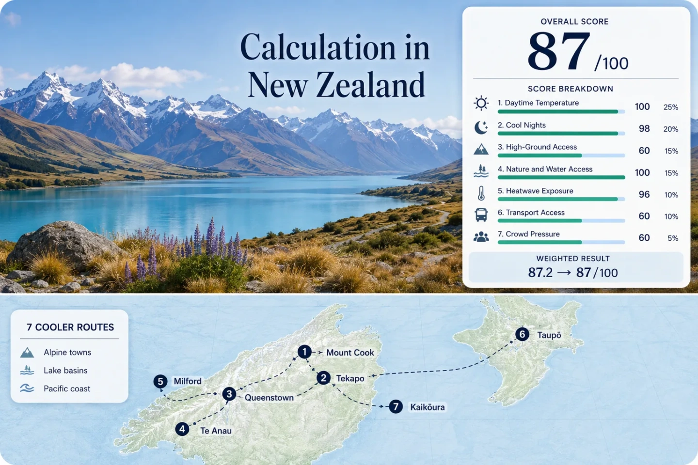
The same destinations appear in the score calculation, marker map, route cards and comparison matrix.
These are normally New Zealand’s warmest months and the main Southern Hemisphere holiday period.
Median January–February average maximum across the seven selected station mappings.
Cooler nights remain a major advantage, particularly around alpine basins and inland lakes.
A dry Southern Alps rain-shadow basin contrasts with one of the country’s wettest inhabited coastal environments.
These bases have the strongest combination of intercity services, local transport or rail access within the route set.
Southern Alps, Lake Basins and Pacific Air Routes
The markers connect high South Island settlements, Fiordland gateways, a central North Island lake base and an exposed Pacific coast. Their spread shows why a New Zealand coolcation is not one continuous climate zone.
Markers show selected cooler-route regions and approximate planning centres, not guaranteed legal parking, trailheads or exact viewpoints. Use the Google Maps link and current access information in each route card before travelling.
New Zealand Alpine and Lake Coolcation Suitability Score
This transparent editorial suitability index uses disclosed climate, landscape, access and peak-pressure factors. It is not an official climate classification, safety rating or weather forecast.
Method: Median January–February average daily maximum, normalised with the fixed daytime-temperature scale.
Raw: Route-set median 20.6°C. Values at or below 21°C receive 100.
Route values: Aoraki / Mount Cook Village 20.6°C; Lake Tekapo 22.2°C; Queenstown 21.9°C; Te Anau represented by Manapouri 20.6°C; Milford Sound 19.8°C; Taupō 23.0°C; Kaikōura 20.3°C.
Source mapping: Direct NIWA-provided station series were used for Mount Cook, Lake Tekapo, Queenstown, Milford Sound, Taupō and Kaikōura. Manapouri is a representative station approximately 19 kilometres south of Te Anau on a comparable low-elevation lake plain. Station codes are not published in the cited presentation tables.
Period: 1991–2020 climate normals.
Sources: NIWA climate station normals product; Mount Cook NIWA averages; Lake Tekapo NIWA averages; Queenstown NIWA averages; Manapouri NIWA averages; Milford Sound NIWA averages; Taupō NIWA averages; Kaikōura NIWA averages.
Method: Median January–February average daily minimum, normalised with the fixed night-cooling scale.
Raw: Route-set median 9.7°C. Linear interpolation between 8°C at 85 points and 10°C at 100 points produces 97.8, rounded to 98.
Route values: Aoraki / Mount Cook Village 8.6°C; Lake Tekapo 8.4°C; Queenstown 9.7°C; Te Anau represented by Manapouri 8.4°C; Milford Sound 10.7°C; Taupō 11.8°C; Kaikōura 13.0°C.
Source mapping: The same station mapping and limitations used for daytime temperature apply. The factor measures average overnight relief rather than record cold or isolated frost events.
Period: 1991–2020 climate normals.
Sources: NIWA climate station normals product; NIWA overview of New Zealand climate; Mount Cook NIWA averages; Lake Tekapo NIWA averages; Queenstown NIWA averages; Manapouri NIWA averages; Milford Sound NIWA averages; Taupō NIWA averages; Kaikōura NIWA averages.
Method: Fixed route rubric based on accommodation-base elevation or meaningful access to higher terrain within approximately 60 minutes. The median route score is used.
Raw: Median categorical score 60.
Route scores: Aoraki / Mount Cook Village 80 — accommodation base near 760 metres; Lake Tekapo 80 — high basin base with nearby Mount John; Queenstown 100 — regular road access from the basin to terrain above 1,500 metres; Te Anau 30 — low base with high terrain requiring longer or more complex access; Milford Sound 30 — sea-level base beneath steep relief but little simple high-ground access; Taupō 60 — accommodation base on the elevated volcanic plateau; Kaikōura 60 — coastal base with meaningful range and trailhead access nearby.
Rationale: Mountain scenery alone does not produce a high score. The rubric measures usable access from the overnight base.
Period: Access conditions reviewed July 2026.
Sources: DOC Aoraki / Mount Cook access information; DOC Hooker Valley Track; DOC Tasman Lake access; DOC Fiordland National Park; DOC Tongariro National Park.
Method: Fixed access rubric measuring whether a large lake, substantial forest, river system or sea coast is physically reachable within 30 minutes. The factor measures access rather than visual quality.
Raw: Median categorical score 100.
Route scores: Aoraki / Mount Cook Village 75 — glacial lake access; Lake Tekapo 75 — immediate large-lake access; Queenstown 100 — Lake Whakatipu plus forested reserves; Te Anau 100 — large lake plus Fiordland forest; Milford Sound 100 — fjord coast plus temperate rainforest; Taupō 100 — large lake, river and forest access; Kaikōura 75 — immediate Pacific coast access.
Period: Physical access reviewed July 2026.
Sources: DOC Hooker Valley Track; DOC Tasman Lake and River Track; DOC Fiordland National Park; DOC Taupō area; DOC Kaikōura area.
Method: Official threshold-frequency fallback. Published annual frequencies of days above 30°C and conservative regional threshold classes were converted to a January–February exposure rate using the 59-day target window. This is less directly comparable than a complete ten-summer daily count.
Raw: Median route estimate 1.4% of target-window days at or above 30°C. Linear interpolation between 1% at 100 points and 2% at 90 points produces 96.
Route values: Aoraki / Mount Cook Village 0.5%; Lake Tekapo 1.4%; Queenstown 1.7%; Te Anau 1.0% representative Southland class; Milford Sound 0.5% representative Fiordland class; Taupō 2.0% representative central plateau class; Kaikōura 1.7%.
Coverage note: These are published-threshold fallbacks rather than exact daily counts. No low-coverage daily series was treated as a complete record. Comparability quality is reduced to C because several routes rely on representative regional classes.
Period: NIWA regional climatologies principally use 1981–2010 station statistics; route suitability reviewed July 2026.
Sources: NIWA climate of Otago; NIWA climate of Canterbury; NIWA overview of New Zealand climate.
Method: Fixed categorical rubric using regular intercity rail or coach access, transfer complexity and the need for private transport after arrival. The median route score is used.
Raw: Median categorical score 60.
Route scores: Aoraki / Mount Cook Village 40 — long limited-frequency coach journey; Lake Tekapo 40 — direct coach access but more than four hours from Christchurch on listed services; Queenstown 100 — airport, regular coaches and urban transport; Te Anau 60 — approximately 2.5 hours by scheduled coach from Queenstown; Milford Sound 20 — remote SH94 access mainly by tour coach or car; Taupō 100 — regular national coach connections and local services; Kaikōura 100 — intercity coach and seasonal daily Coastal Pacific rail access.
Period: Published service information checked July 2026. Timetables can change seasonally.
Sources: InterCity route map; InterCity South Island travel times; Queenstown to Te Anau coach; Great Journeys New Zealand timetables; Kaikōura railway station; DOC Milford Road driving information.
Method: Categorical fallback using official booking requirements, seasonal transport capacity, park access warnings and known concentration of visitor activity. The median route score is used because route-level accommodation occupancy was not available on one consistent basis for all seven locations.
Raw: Median categorical score 60.
Route scores: Aoraki / Mount Cook Village 40 — constrained village and trailhead capacity with advance-booking pressure; Lake Tekapo 60 — concentrated lakefront demand during the holiday period; Queenstown 20 — widespread accommodation and activity pressure; Te Anau 60 — gateway demand with a broader service base; Milford Sound 20 — busy SH94 corridor and concentrated tour arrivals; Taupō 60 — strong holiday and event weekends; Kaikōura 60 — seasonal rail reservations and concentrated marine-tour demand.
Period: Current access and booking rules reviewed July 2026; categorical evidence principally reflects the latest published operational information.
Sources: DOC Aoraki visitor information; DOC Mueller Hut booking requirements; DOC Milford Road peak-season warning; Coastal Pacific reservations and season.
Alpine Settlements, Fiordland Water and Pacific Coast Bases
The portfolio deliberately mixes dry high-country basins with wet maritime environments. A low national-looking score distortion is avoided by assessing every route equally rather than allowing one cold mountain settlement to represent the whole country.
Aoraki / Mount Cook Village
A January–February average high near 20.6°C combines with an average low near 8.6°C. The village sits directly beneath the country’s highest peaks, while Hooker Valley and Tasman Lake provide lower-gradient options when higher routes are unsuitable.
SH80 is a single access corridor from the Mackenzie Basin. Coach connections exist, but limited frequency and long travel times make timetable alignment important. Accommodation, parking and selected alpine facilities can fill during the summer holiday period.
Lake Tekapo and the Mackenzie Basin
Lake Tekapo’s January and February average highs are close to 22.2°C, while average lows remain near 8.4°C. The basin’s elevation and Southern Alps rain shadow support a drier summer profile than Fiordland, but clear skies can intensify afternoon sun.
The settlement is directly connected by intercity coach, yet the journey from Christchurch exceeds four hours on listed services. The lakeshore is immediate, and Mount John supplies a nearby elevation change without requiring a long transfer.
Queenstown and the Whakatipu Mountain Rim
Queenstown’s route-mapped station averages about 21.9°C by day and 9.7°C at night across January and February. Lake Whakatipu moderates the setting, while roads toward Coronet Peak and other elevated areas create the strongest practical high-ground access in the portfolio.
The airport, intercity coaches and urban bus network make Queenstown the most adaptable South Island base without a private car. That accessibility is offset by high accommodation and activity pressure during the school-holiday period.
Te Anau and the Eastern Fiordland Gateway
Manapouri, used as the representative climate station, averages roughly 20.6°C for January–February daytime highs and 8.4°C for overnight lows. Te Anau combines immediate lake access with forested Fiordland routes and usually offers a calmer overnight base than Milford Sound itself.
Scheduled coach travel from Queenstown takes roughly 2.5 hours. High alpine terrain is visible and geographically close, but practical access often involves longer drives, boat connections or demanding tracks, which limits the mountain-access score.
Milford Sound / Piopiotahi
Milford Sound has the lowest daytime average in the route set, near 19.8°C across January and February, with average lows close to 10.7°C. Sea-level fjord air and frequent cloud limit sustained heat, but annual rainfall is exceptionally high and conditions can shift quickly.
SH94 is remote, exposed to weather disruption and especially busy from October through April. Tour coaches reduce the need to drive, although they concentrate arrivals into a narrow daily window and provide less flexibility during changing conditions.
Taupō and the Central Volcanic Plateau
Taupō is the warmest station mapping in the portfolio, with January–February average highs near 23.0°C, but its elevated plateau setting and large lake prevent it from behaving like a lowland inland city. Average lows around 11.8°C still provide useful overnight relief.
Regular coach connections, local services and a broad accommodation base make Taupō the strongest North Island option for a route that does not depend entirely on a car. Higher volcanic terrain is accessible as a separate day trip, subject to weather and transport arrangements.
Kaikōura Between the Pacific and Seaward Range
Kaikōura’s January–February station averages are approximately 20.3°C by day and 13.0°C at night. The narrow coastal strip receives maritime air directly, while the Seaward Kaikōura Range rises abruptly inland and creates a stronger coast-to-mountain contrast than the town’s low elevation suggests.
The Coastal Pacific normally provides daily summer rail service, complemented by intercity coaches. Rail operation is seasonal, so a summer booking can be simple while an off-season plan may require a different connection.
Seven Routes Compared by Heat, Access and Weather Trade-Off
All seven score routes remain in the primary comparison. Temperature values are January–February averages from the station mappings used in the score rather than real-time forecasts.
| Route | Average High / Low | Main Cooling Mechanism | Car-Light Access | Primary Trade-Off |
|---|---|---|---|---|
| Aoraki / Mount Cook Village | 20.6°C / 8.6°C | High alpine base and cool nights | Limited-frequency coach | Constrained capacity and rapidly changing mountain weather |
| Lake Tekapo | 22.2°C / 8.4°C | High basin elevation and lake exposure | Direct long-distance coach | Clear-sky sun exposure despite cool air |
| Queenstown | 21.9°C / 9.7°C | Lake basin with quick high-road access | Strong | Peak accommodation and activity pressure |
| Te Anau and Lake Te Anau | 20.6°C / 8.4°C | Large lake, forest and cool overnight air | Scheduled coach from Queenstown | Higher terrain often needs longer transfers |
| Milford Sound / Piopiotahi | 19.8°C / 10.7°C | Maritime fjord air, cloud and rainforest | Tour coach rather than flexible local network | Very high rainfall and remote-road exposure |
| Taupō and Lake Taupō | 23.0°C / 11.8°C | Elevated volcanic plateau and large lake | Strong | Warmer afternoons and busy holiday weekends |
| Kaikōura | 20.3°C / 13.0°C | Direct Pacific air beside steep ranges | Strong in the summer rail season | Less overnight cooling than inland alpine basins |
The Southern Alps Divide Dry Basins from Wet Fiordland
The west-to-east rainfall contrast is one of the most consequential planning differences in the country. It changes clothing, road reliability, visibility and backup-activity needs even when average temperatures appear similarly cool.
Mackenzie Basin: Cooler Nights with Stronger Sun
Lake Tekapo records roughly 535 millimetres of annual rainfall in the cited NIWA series, reflecting the rain-shadow effect east of the Southern Alps. Lower humidity and clearer skies can feel comfortable in shade, yet exposed afternoon conditions may feel warmer than the air temperature suggests.
Fiordland: Lower Heat with Far More Rain
Milford Sound records more than 6,500 millimetres of annual rainfall in the same national dataset. Cloud, maritime air and frequent precipitation reduce sustained heat, but wet-road visibility, waterfall runoff and weather-driven delays become central travel variables.
Otago Basins: Cool Nights Do Not Remove Heat Bursts
Queenstown’s averages remain moderate, but Central Otago’s continental influence allows occasional temperatures above 30°C. A lake or mountain itinerary should retain shaded alternatives rather than assuming every day in an alpine landscape stays cool.
Planning implication: Tekapo benefits from dry-air reliability but needs sun management; Milford benefits from low daytime heat but needs a rain-resilient schedule.
SH80 and SH94 Create Two Different Alpine Access Problems
SH80 Ends at Aoraki / Mount Cook
State Highway 80 forms a long out-and-back alpine corridor rather than a through route. A weather change, parking shortage or accommodation issue cannot always be solved by continuing onward to another town. Lake Tekapo or Twizel can function as lower-pressure fallback bases, but each adds driving time to mountain activities.
SH94 Crosses Remote Fiordland Terrain
The Milford Road carries cars, coaches, cyclists and stopping traffic through a remote national-park corridor. DOC identifies October through April as the busy period. Fuel, food, mobile coverage and road-status checks should be handled before leaving Te Anau.
Aoraki planning is dominated by terminal-road capacity; Milford planning is dominated by remoteness, weather exposure and concentrated daily traffic.
Where a New Zealand Coolcation Works Without Continuous Driving
Queenstown for the Widest Service Network
Air access, urban buses and intercity coaches allow a multi-day stay without collecting a car immediately. Higher roads and remote trailheads may still require a tour, shuttle or rental day.
Kaikōura for a Coastal Rail Arrival
The Coastal Pacific creates a distinctive summer option between Christchurch and Picton. Its seasonal operating calendar must be checked before building an itinerary around rail.
Taupō for North Island Coach Connections
Taupō links naturally with major North Island intercity routes. Lakefront and urban activities are accessible after arrival, while volcanic-park days need a separate transport plan.
Aoraki, Tekapo, Te Anau and Milford can all be reached without driving, but limited departures make them timetable-led routes rather than flexible public-transport bases.
Long Summer Light Does Not Guarantee Stable Alpine Hours
January and February provide long usable evenings, yet mountain and fjord weather can compress an outdoor day into a much shorter safe window. High ultraviolet levels also mean that cool air, cloud breaks and wind can disguise sun exposure.
Use Early Hours for Exposed Alpine Routes
At Aoraki, Tekapo and Queenstown, earlier starts reduce direct-sun exposure and leave more time to respond to wind, cloud or track-condition changes.
Keep a Fiordland Rain Alternative
Te Anau provides a more practical base for changing plans than committing every night to the Milford corridor. Forest walks, lakefront time and visitor facilities can absorb a poor-visibility day.
Treat Coastal Wind as a Separate Variable
Kaikōura and Milford can remain thermally mild while wind changes marine conditions, walking comfort and transport reliability. Temperature alone is an incomplete decision measure.
Final Checks for January and February Routes
Reserve constrained segments first: Aoraki accommodation, selected alpine huts, Milford activities and limited-capacity scenic transport can determine the rest of the itinerary.
Check the route rather than only the town forecast: SH80, SH94, alpine tracks, marine departures and volcanic-plateau access can operate under different conditions from the nearest accommodation base.
Carry both sun and rain protection: The same trip can move from the dry Mackenzie Basin to Fiordland rainfall, with a substantial change in exposure over a relatively short geographic distance.