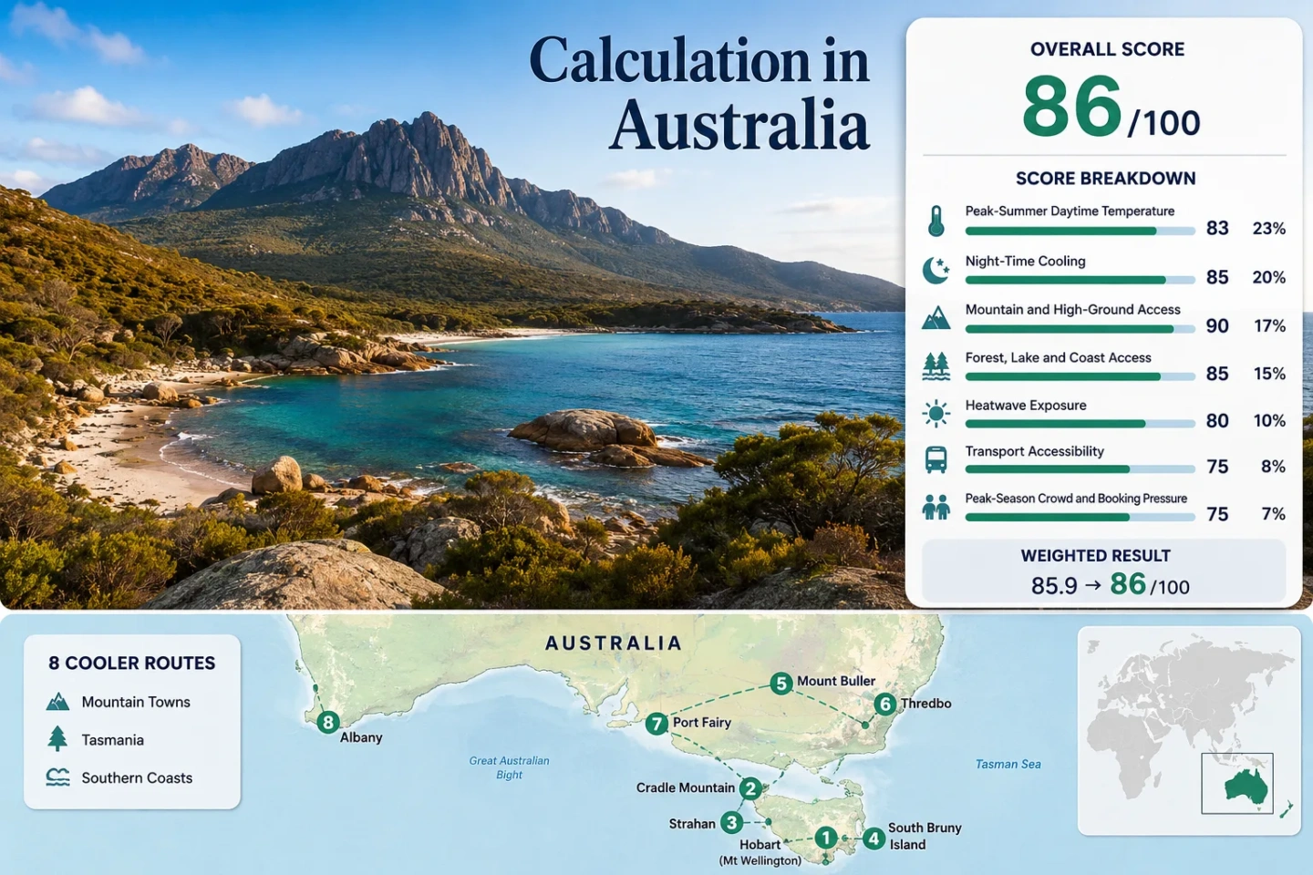
Tasmania offers cool escapes in Australia with stunning mountain towns and southern coast scenic views.

Australia for Cooler Escapes: Tasmania, Mountain Towns and Southern Coasts

Australia’s most dependable summer relief is concentrated in the far south and at altitude. Tasmania combines cool maritime air, rainforest shade and alpine plateaus; Mount Buller and Thredbo place overnight bases above 1,300 metres; Port Fairy and Albany trade inland heat for exposed Southern Ocean weather. The strongest choices are not uniformly mild every day, but they provide measurable reductions in daytime heat, cooler sleeping temperatures or rapid access to higher ground during January and February.

Routes Assessed
8

Four Tasmanian bases, two alpine towns and two Southern Ocean coastal routes; route count adds no score bonus.

Route Daytime Median
21.3°C

January–February mean maximum temperature across the eight official station mappings.

Night-Cooling Median
11.3°C

The route median sits inside the scoring band associated with useful overnight relief.

Lowest-Heat Base
Cradle Mountain

The historical Cradle Valley station averages 16.8°C by day across January and February.

Heat-Threshold Median
3.1%

Official station threshold-frequency fallback for days reaching at least 30°C.

Main Access Trade-Off
Ferry, Shuttle or Lift

Bruny Island, Cradle Mountain and Thredbo require timing around a ferry, park shuttle or operating chairlift.

Tasmania, Alpine Towns and Southern Ocean Route Geography

The route set stretches from Western Australia’s south coast to the Australian Alps and Tasmania. The marker pattern makes the main cooling mechanisms visible: southern latitude, exposed ocean air, high settlement elevation and fast access to forested or alpine terrain.

Markers show selected cooler-route regions and planning centres, not guaranteed legal parking, trailheads or exact viewpoints. Use each route card for Google Maps links and access notes before travelling.

Australia Southern and High-Ground Cooler Escape Suitability Score

This transparent editorial suitability index uses disclosed climate, landscape, access and pressure factors. It is not an official climate classification or a weather forecast. The score represents the eight named routes rather than Australia as a whole.

86 out of 100
Calculated from 7 disclosed factors
Target summer windowJanuary–February
Climate baselineOfficial BOM station records; mixed long-term periods, with 1991–2020 selectable where available
Heatwave data periodOfficial station threshold-frequency records; mixed long-term periods
Routes assessed8 routes
MethodologyVersion 1.2
Last reviewedJuly 15, 2026
Factor coverage7/7
Comparability qualityB — Official data with mixed station periods, one closed historical mountain station and threshold-frequency fallback
Peak-Summer Daytime Temperature25%
99/100
Method: Official Station aggregation using the mean of January and February mean maximum temperatures for each route, followed by the route median and fixed linear normalization. Raw: 21.3°C route median, normalized to 98.5 and rounded to 99/100. Route values: Hobart and kunanyi / Mount Wellington 21.8°C; Cradle Mountain 16.8°C; Strahan and the West Coast 21.2°C; South Bruny Island 18.5°C; Mount Buller 17.4°C; Thredbo 21.4°C; Port Fairy 22.8°C; Albany and Torndirrup Coast 24.9°C. Median: 21.3°C. Source mapping: Hobart — Direct Station HOBART (ELLERSLIE ROAD), BOM 094029, 51 m, city base beneath kunanyi; Cradle Mountain — Direct historical Station CRADLE VALLEY (WALDHEIM), BOM 096005, 903 m, closed 2009; Strahan — Direct Station STRAHAN AERODROME, BOM 097072, 21 m; South Bruny Island — Representative on-island Station CAPE BRUNY LIGHTHOUSE, BOM 094010, 55 m; Mount Buller — Direct Station MOUNT BULLER, BOM 083024, 1,707 m; Thredbo — Direct Station THREDBO VILLAGE, BOM 071041, 1,380 m; Port Fairy — Direct Station PORT FAIRY AWS, BOM 090175, 10 m; Albany — Representative Station ALBANY AIRPORT COMPARISON, BOM 009741, 68 m, approximately 12 km from central Albany and closed 2014. Period: All-years official station summaries, with station records beginning between 1882 and 1990 and ending between 1977 and 2026; mixed periods are disclosed rather than presented as one common normal. Sources: BOM Hobart 094029; BOM Cradle Valley 096005; BOM Strahan 097072; BOM Cape Bruny 094010; BOM Mount Buller 083024; BOM Thredbo Village 071041; BOM Port Fairy 090175; BOM Albany Airport Comparison 009741.
Night-Time Cooling20%
100/100
Method: Official Station aggregation using the mean of January and February mean minimum temperatures for each route, followed by the route median. Raw: 11.3°C route median, within the fixed 10–16°C full-score band. Route values: Hobart and kunanyi / Mount Wellington 12.1°C; Cradle Mountain 5.6°C; Strahan and the West Coast 10.9°C; South Bruny Island 11.7°C; Mount Buller 9.1°C; Thredbo 7.3°C; Port Fairy 14.4°C; Albany and Torndirrup Coast 14.1°C. Median: 11.3°C. Source mapping: The same eight BOM station mappings, station IDs, elevations and route relationships used for daytime temperature were retained so the two climate medians use one consistent route set. Period: All-years official station summaries; mixed long-term periods and closed historical stations are reflected in comparability quality B. Sources: BOM Hobart; BOM Cradle Valley; BOM Strahan; BOM Cape Bruny; BOM Mount Buller; BOM Thredbo Village; BOM Port Fairy; BOM Albany Airport Comparison.
Mountain and High-Ground Access15%
55/100
Method: Fixed categorical rubric based on accommodation-base elevation and meaningful high-ground access within approximately 60 minutes. Raw: Route-score median 55/100. Route scores: Hobart and kunanyi / Mount Wellington 80 — Hobart base with sealed-road or shuttle access to the 1,271 m pinnacle; Cradle Mountain 100 — route base and direct station at 903 m; Strahan and the West Coast 30 — low coastal base with high terrain reached only by a substantial eastbound detour; South Bruny Island 30 — limited island relief and no 1,000 m high ground; Mount Buller 100 — village and station at 1,707 m; Thredbo 100 — village at 1,380 m with lift or walking access toward the Main Range; Port Fairy 0 — sea-level coast without meaningful high ground inside the time threshold; Albany and Torndirrup Coast 30 — coastal base with the Stirling Range beyond the normal one-hour access band. Median: 55/100. Route rationale: The Tasmania subset mixes one true alpine base, one fast mountain ascent and two low maritime bases; the mainland subset contains two high villages and two low coasts. Period: Access and elevation conditions reviewed July 15, 2026. Sources: Wellington Park access and elevations; Tasmania Parks Cradle Mountain access; Mount Buller access; NSW National Parks Thredbo–Perisher access; official BOM station pages linked in the climate factors for base elevations.
Forest, Lake and Coast Access15%
100/100
Method: Fixed categorical rubric measuring physical access to substantial forest, lake, river or sea systems rather than scenery quality. Raw: Route-score median 100/100. Route scores: Hobart and kunanyi / Mount Wellington 100 — Derwent estuary plus extensive forested mountain slopes; Cradle Mountain 100 — glacial lakes plus rainforest and alpine woodland; Strahan and the West Coast 100 — Macquarie Harbour, Gordon River access and temperate rainforest; South Bruny Island 100 — exposed coast plus national-park forest; Mount Buller 75 — strong alpine-forest access; Thredbo 75 — alpine forest, streams and high-country watercourses; Port Fairy 75 — immediate Southern Ocean coast; Albany and Torndirrup Coast 100 — ocean coast plus forested national-park terrain. Median: 100/100. Route rationale: Five routes meet the two-element full-score threshold; the remaining three have one strong water or forest system inside 30 minutes. Period: Physical-access conditions reviewed July 15, 2026. Sources: Cradle Mountain–Lake St Clair National Park; Franklin-Gordon Wild Rivers National Park; South Bruny National Park; Kosciuszko National Park.
Heatwave Exposure10%
85/100
Method: Official threshold-frequency fallback. Each station’s published mean number of January and February days reaching at least 30°C was summed and divided by 59 calendar days. This is not presented as a latest-ten-summers daily count. Raw: 3.05% route median, normalized to 84.7 and rounded to 85/100. Route values: Hobart and kunanyi / Mount Wellington 5.9% — 3.5 published days per 59-day window; Cradle Mountain 0.3% — 0.2 days; Strahan and the West Coast 4.2% — 2.5 days; South Bruny Island 1.9% — 1.1 days; Mount Buller 0.0% — 0.0 days; Thredbo 1.7% — 1.0 day; Port Fairy 9.0% — 5.3 days; Albany and Torndirrup Coast 12.0% — 7.1 days. Median: 3.05%. Source mapping: Published threshold-frequency values came from the same eight BOM station mappings used for the temperature factors. Daily-series coverage is not claimed because the accepted official threshold-frequency fallback was used. Period: Station-specific climatological records shown on each BOM table; records are heterogeneous and range from historical Cradle data to open stations updated in 2026. Sources: BOM Hobart 30°C threshold; BOM Cradle Valley threshold; BOM Strahan threshold; BOM Cape Bruny threshold; BOM Mount Buller threshold; BOM Thredbo threshold; BOM Port Fairy threshold; BOM Albany threshold.
Transport Accessibility10%
60/100
Method: Fixed categorical transport rubric using regular scheduled services, transfer complexity, travel duration and local vehicle dependence. Raw: Route-score median 60/100. Route scores: Hobart and kunanyi / Mount Wellington 80 — city base with summit shuttle and road access inside two hours; Cradle Mountain 60 — intercity transfer or coach plus mandatory park shuttle during operating hours; Strahan and the West Coast 40 — long regional access and limited frequency; South Bruny Island 20 — ferry plus strongly car-dependent island movement; Mount Buller 40 — approximately three hours from Melbourne with summer driving or booked transfer; Thredbo 60 — transfer through Jindabyne with coach or arranged transport and local lift dependence for the shortest summit route; Port Fairy 100 — regular V/Line rail-and-coach path with direct coach arrival in town; Albany and Torndirrup Coast 100 — regular Transwa coach reaches Albany without a private car. Median: 60/100. Route rationale: The two public-transport coastal towns balance the ferry, remote west-coast and alpine-transfer routes, leaving the portfolio at the middle access band. Period: Timetables and access arrangements reviewed July 15, 2026. Sources: Wellington Park getting there; Cradle Mountain shuttle information; Transport Tasmania Bruny Island Ferry; Mount Buller journey information; Kosciuszko National Park visitor access; V/Line Warrnambool and Port Fairy connections; Transwa Perth–Albany coach.
Peak-Season Crowd and Booking Pressure5%
60/100
Method: Categorical fallback using official parking, shuttle, ferry, pass, booking and capacity information because one comparable January–February accommodation-occupancy series was not available for all eight routes. Raw: Route-score median 60/100. Route scores: Hobart and kunanyi / Mount Wellington 60 — 65 spaces at The Springs, 100 at the summit and capacity-dependent road access; Cradle Mountain 40 — managed shuttle access, no private vehicles during shuttle hours and only limited Dove Lake parking outside those hours; Strahan and the West Coast 60 — daily Gordon River cruise capacity and concentrated waterfront departures encourage advance planning; South Bruny Island 40 — ferry queues and additional peak-period travel time; Mount Buller 80 — lower summer pressure with free village driving and parking; Thredbo 60 — lift operating windows, park entry and summer event weekends create periodic pressure; Port Fairy 60 — concentrated coastal holiday demand and reservable regional services; Albany and Torndirrup Coast 60 — summer holiday demand is spread across a larger town but coastal parks and accommodation still tighten around peak dates. Median: 60/100. Route rationale: Capacity pressure is concentrated at specific gateways rather than across every route: Dove Lake shuttle operations, the Bruny ferry, kunanyi summit parking and lift-dependent alpine access are the main constraints. Period: Current official operating and capacity information reviewed July 15, 2026. Sources: City of Hobart summit parking information; Cradle Mountain managed shuttle access; South Bruny peak-period ferry advice; Mount Buller summer parking; Thredbo chairlift-dependent access.

Weighted total: 99×0.25 + 100×0.20 + 55×0.15 + 100×0.15 + 85×0.10 + 60×0.10 + 60×0.05 = 85.5 → 86/100

Method: Route count does not add bonus points. Each route carries equal weight inside a factor, route-level values are combined by the median, and the seven fixed factor weights total 100%.

Read the Cooler Escape scoring methodology

Tasmanian Highlands, Alpine Villages and Southern Ocean Bases

The portfolio separates three different forms of summer relief. Tasmania supplies the broadest concentration of mild routes, the Australian Alps provide the lowest-elevation-adjusted heat exposure, and the two mainland coastal towns retain urban services while staying open to Southern Ocean air.

1

Hobart and kunanyi / Mount Wellington

Hobart’s city base averages 21.8°C by day and 12.1°C at night across January and February at BOM station 094029. The route changes character quickly: central Hobart sits near sea level, The Springs reaches 720 m, and the sealed Pinnacle Road continues to about 1,271 m.

City plus mountain21.8°C day median inputSummit road

The City of Hobart lists 65 parking spaces at The Springs and 100 at the summit, so a clear morning does not guarantee easy parking. The summit road can close for snow, ice or severe conditions even outside winter, while the mountain shuttle may continue when conditions allow.

Works for: Travellers who want restaurants, museums and airport access without giving up a same-day move into cold, windy mountain air.

Hobart and kunanyi / Mount Wellington on Google Maps

2

Cradle Mountain

Cradle Mountain is the lowest-heat base in the route set. The historical Cradle Valley station at 903 m averages 16.8°C for daytime maxima and 5.6°C for minima across January and February. Those nights can feel cold rather than merely mild, especially after rain or wind.

Private vehicles are not permitted on Dove Lake Road during shuttle operating hours. The park shuttle takes about 20 minutes from the visitor centre to Dove Lake, and only limited parking is available outside operating hours.

903 m station16.8°C daytime5.6°C nightsManaged shuttle
Main caution: The direct climate station closed in 2009, so the temperature signal is strong but less current than the open-station records used for most other routes.

Cradle Mountain on Google Maps

3

Strahan and the West Coast

Strahan averages 21.2°C by day and 10.9°C at night in the target window at BOM station 097072. The cooling mechanism is maritime exposure and cloud-prone western weather rather than elevation; the station sits at only 21 m.

Macquarie Harbour, lower Gordon River cruises and nearby temperate rainforest create a water-and-forest route with strong weather variability. Franklin-Gordon Wild Rivers National Park can be approached by the Lyell Highway, while the lower Gordon River is reached by daily commercial cruises from Strahan.

Watch for: Rain and low cloud can reduce heat but also remove visibility, delay outdoor plans and make the west-coast drive slower.
21.2°C daytimeHarbour airRainforest access

Strahan and the West Coast on Google Maps

4

South Bruny Island

The Cape Bruny Lighthouse station gives the route a January–February average of 18.5°C by day and 11.7°C at night. The island’s advantage comes from direct exposure to the D’Entrecasteaux Channel and Southern Ocean rather than high ground.

The vehicle-and-passenger ferry from Kettering runs daily and normally crosses in 15–20 minutes. South Bruny National Park advises allowing additional time during peak periods; movement beyond Roberts Point is much easier with a vehicle because the southern island combines sealed and unsealed roads.

18.5°C daytimeDaily ferryCar-dependent island

Good for: Coastal walks, lighthouse weather and cool-air days when the mainland side of Hobart is warmer.

South Bruny Island on Google Maps

5

Mount Buller

Mount Buller’s direct BOM station sits at 1,707 m and averages 17.4°C by day and 9.1°C at night across January and February. The published long-term threshold frequency is 0.0 days at or above 30°C for the two target months.

Summer access is simpler than winter access: vehicles can drive into the village without the winter resort-entry arrangement, and the resort states that summer parking is free. Melbourne is about 248 km away, so the main trade-off is the three-hour road journey rather than local heat.

Why it stands out: It combines the route set’s second-lowest daytime value with an overnight base high enough to avoid returning to a hot lowland town.

Mount Buller on Google Maps

6

Thredbo

Thredbo Village is mapped by a direct BOM station at 1,380 m. Its January–February averages are 21.4°C by day and 7.3°C at night, producing stronger sleeping relief than the coastal routes even when daytime sunshine is warm.

The shortest Mount Kosciuszko approach begins after a roughly 15-minute chairlift ride, followed by the elevated Kosciuszko walk. Walking from the village without the lift adds a steep 4 km ascent that NSW National Parks estimates at 2–3 hours uphill.

1,380 m village7.3°C nightsChairlift timingPark entry
Watch for: Chairlift hours, thunderstorms, strong ultraviolet exposure and fast alpine weather changes can matter more than the town’s daily maximum.

Thredbo on Google Maps

7

Port Fairy

Port Fairy AWS sits 10 m above sea level and averages 22.8°C by day and 14.4°C at night in January and February. That is milder at night than the alpine routes, but the open coast gives the town a more usable evening temperature profile than many inland Victorian bases.

V/Line services connect Melbourne with Warrnambool by train and continue to Port Fairy by coach. The route can therefore work without a private car, although beaches, volcanic plains and outlying coastal points are easier to combine by vehicle or bicycle.

Direct regional coach22.8°C daytimeSouthern Ocean coast

The official threshold-frequency fallback is 5.3 days at or above 30°C across the two-month window, equal to about 9.0% of January–February days. A sea breeze is useful, but it does not eliminate short hot northerly episodes.

Port Fairy on Google Maps

8

Albany and Torndirrup Coast

Albany Airport Comparison station averages 24.9°C by day and 14.1°C at night for January and February. It is the warmest route in the portfolio, yet it remains materially different from inland Western Australia because the city and Torndirrup coastline are open to persistent Southern Ocean weather.

Transwa runs regular Perth–Albany coach services, making the city centre reachable without driving. Torndirrup National Park, coastal lookouts and forested headlands still favour a vehicle or organised local tour once in Albany.

Main caution: The mapped climate station closed in 2014 and the official threshold fallback reaches 7.1 days at or above 30°C across the two target months, about 12.0% of the window.
Transwa coach24.9°C daytimeOcean and forest

Albany and Torndirrup Coast on Google Maps

Tasmania’s City, West-Coast and Alpine Temperature Bands

Tasmania should not be treated as one cool island average. The four Tasmanian routes occupy distinct bands that change packing, driving and backup-plan decisions.

Alpine base: Cradle Mountain

At 903 m, Cradle’s 16.8°C daytime and 5.6°C night values are far below Hobart’s. Warm clothing and wet-weather layers remain relevant in midsummer, and the managed shuttle controls access to Dove Lake.

Western maritime base: Strahan

Strahan’s 21.2°C daytime value resembles Hobart, but cloud, rain and Macquarie Harbour exposure create a different comfort pattern. Visibility and road conditions are a larger planning risk than heat alone.

Southern island edge: South Bruny

Cape Bruny’s 18.5°C daytime average is cooler than Hobart, yet the ferry adds a fixed gateway. A warm Hobart forecast can justify the crossing only when ferry queues and island road time are included.

Urban-to-mountain switch: Hobart and kunanyi

Hobart is the service-rich base, while kunanyi supplies a rapid altitude change to 1,271 m. Parking capacity and road status determine whether that cooling advantage is immediately usable.

Ferry, Shuttle and Chairlift Timing Can Override the Thermometer

Bruny Ferry Window

The Kettering crossing operates every day and normally takes 15–20 minutes, but peak-period queues can erase the value of a short cool-air day trip. Earlier outbound travel and a realistic return queue are part of the route calculation.

Cradle Shuttle Window

Dove Lake Road becomes a managed public-transport corridor during shuttle hours. The arrangement reduces parking conflict near the lake, but it also means the day begins at the visitor centre rather than at a freely chosen trailhead.

Thredbo Lift Window

The Kosciuszko Express removes a steep 4 km climb and places walkers near the Main Range in about 15 minutes. When the lift is closed, weather-delayed or outside operating hours, the same route requires a longer and more strenuous plan.

Decision rule: A cooler forecast is not enough when the route depends on a ferry queue, a shuttle timetable or a chairlift. Check the gateway first, then compare temperature.

Eight-Route Summer Decision Matrix

The same eight routes used by the map and score are compared here. Temperature values are January–February means from the disclosed BOM station mappings; transport and pressure fields use the fixed categorical rubrics.

RouteMean MaxMean Min30°C+ FallbackHigh-Ground ScoreTransport ScorePrimary Trade-Off
Hobart and kunanyi / Mount Wellington21.8°C12.1°C5.9%8080Summit parking and road status
Cradle Mountain16.8°C5.6°C0.3%10060Managed shuttle and cold wet weather
Strahan and the West Coast21.2°C10.9°C4.2%3040Long access and frequent rain
South Bruny Island18.5°C11.7°C1.9%3020Ferry queue and vehicle dependence
Mount Buller17.4°C9.1°C0.0%10040Three-hour road approach
Thredbo21.4°C7.3°C1.7%10060Lift hours and alpine exposure
Port Fairy22.8°C14.4°C9.0%0100Short hot northerly episodes
Albany and Torndirrup Coast24.9°C14.1°C12.0%30100Warmer baseline and local car need

January Heat-Burst Backup Logic across Southern Australia

Southern locations can still receive brief hot northerly or north-westerly airflow. The useful distinction is how quickly each base can move toward altitude, colder water or a more exposed coast when a hot day appears.

When Lowest Heat Is the Priority

Cradle Mountain and Mount Buller carry the lowest January–February daytime values in the route set. Cradle is cooler overall but wetter and more access-managed; Mount Buller is easier to move around by car in summer but requires a long approach from Melbourne.

When Car-Light Access Matters More

Port Fairy and Albany have the strongest scheduled intercity links. Their temperature advantage is smaller than the alpine routes, so they work more as service-rich coastal bases than as guaranteed low-heat refuges.

When One Base Must Cover City and Mountain

Hobart and kunanyi / Mount Wellington provide the clearest same-day switch from urban services to high ground. The route is strongest when the summit road is open and parking pressure is manageable.

When Ocean Exposure Is the Main Tool

South Bruny, Strahan, Port Fairy and Albany depend on maritime airflow rather than high elevation. Wind direction matters: a cool onshore pattern can be valuable, while hot continental airflow can temporarily remove the coastal advantage.

Forecast check: Compare the city or town forecast with summit, park or coastal observations on the morning of travel. A route selected for altitude can fail because of road or lift closure, while a route selected for sea air can fail under hot offshore wind.
📌

Complete guide: Oceania