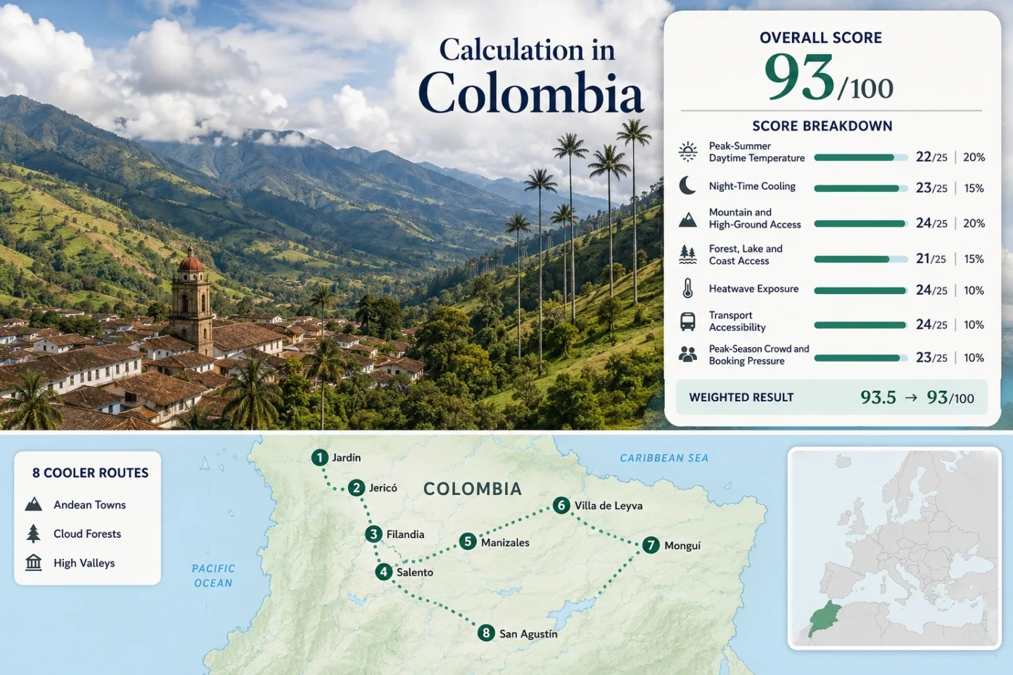
Colombia for Springlike Escapes: Andean Towns, Cloud Forests and High Valleys
Colombia’s mildest travel conditions are found by changing elevation rather than waiting for a conventional spring. The eight routes assessed here rise from the green valleys of Antioquia and Huila to the colder highlands of Boyacá, separating warm-mild town days, damp cloud-forest air, dry high-valley sun and genuinely cold páramo approaches.
San Agustín sits near the lower end of the selected bases; Monguí marks the cool-highland end before nearby páramo terrain rises farther.
Median of the eight route-level mean daily maximum proxies, not a national temperature average.
Cool nights are a consistent strength, although Monguí can feel cold while Jericó remains noticeably softer after sunset.
Jardín, Filandia, Salento and Manizales trade brighter skies for cloud-forest moisture and fast local weather changes.
Villa de Leyva and Monguí can feel drier by day, yet shade and sunset expose the altitude quickly.
Filandia, Salento and Manizales form the most practical cluster for regular buses, regional terminals and short transfers.
From Antioquia Valleys to the Colombian Massif
The markers connect eight distinct elevation bases across four Andean settings: Antioquia mountain towns, the Coffee Cultural Landscape, Boyacá high valleys and the southern Colombian Massif.
Markers show selected cooler-route regions and approximate planning centers, not guaranteed legal parking, trailheads or exact viewpoints. Use each destination card for its named Google Maps search and access notes.
Colombia Andean Cooler Escape Suitability Score
This transparent editorial suitability index uses disclosed climate, landscape, access and pressure factors. It is not an official climate classification or a weather forecast. The result represents the eight displayed routes, not Colombia as a whole.
Weighted total: 100×0.25 + 100×0.20 + 100×0.15 + 88×0.15 + 100×0.10 + 60×0.10 + 80×0.05 = 93.2 → 93/100
Aggregation: Route count adds no bonus. Each route carries equal weight inside a factor, and the route median limits the influence of one unusually cold or unusually accessible place.
Data caution: Temperature uses published gridded town climatology rather than a uniform network of direct IDEAM station series. Landscape, transport and crowd factors use disclosed categorical rubrics. Heatwave exposure is a daily-climatology threshold proxy, not an observed event frequency. These limitations support a C comparability grade.
Eight Elevation Bases Across Colombia’s Andes
The route set moves between three different meanings of springlike weather: mild green valleys, cool cloud-forest towns and high settlements where daytime sun can conceal cold evenings.
Jardín: Mild Valley Streets with Wetter Forest Slopes
Jardín occupies a green Antioquia basin where the town center can feel mild and sociable while surrounding slopes turn cooler, dimmer and wetter. The temperature signal is attractive for heat avoidance, but the comfort trade-off is moisture: shaded paths, cable-car approaches and forest tracks can stay slick after rain even when the plaza has brightened.
The route works particularly well for travelers who want comfortable town days without moving into cold-highland territory. It also supports a slower stay because daily needs are concentrated around the compact center. Higher viewpoints are not simply cooler versions of the plaza; cloud, drizzle and reduced visibility can arrive first on the slopes.
Jericó: Brighter Antioquia Slopes and Softer Nights
Jericó sits near 1,950 m, yet its July–August temperature proxy is warmer than Jardín’s: about 25.0°C for mean daily maxima and 14.9°C for minima. That makes it the route for travelers who want Andean altitude without the colder night signal found in Boyacá or the damp chill that can settle over western cloud-forest paths.
Open slopes and exposed streets can feel substantially warmer than the numerical altitude suggests.
Cloudier high ground provides a distinct second climate above the town.
Jericó’s value lies in contrast rather than uniform coolness. Sunlit hours can support terrace time and unhurried walking, while the upper slopes offer mist, forest and a sharper temperature drop. The town generally carries less concentrated visitor pressure than Salento, though holiday weekends still change room availability and road rhythm.
Filandia: Cloud-Forest Cooling without Cocora’s Main Visitor Flow
Filandia combines a walkable highland town with rapid access to the Barbas–Bremen forest corridor. The town can brighten between showers, but the forest adds shade, humidity and low cloud, producing a cooler sensory environment than an exposed high valley at the same thermometer reading.
Mist is not the same as sustained rain. Low cloud can reduce visibility and dampen vegetation without producing an all-day downpour; short showers can still leave clay paths and roots slippery. Footwear and drying time therefore matter even when the forecast shows only moderate temperatures.
Salento and Cocora Valley: One Base, Two Weather Profiles
Salento’s accommodation base is near 1,900 m, with a July–August mean maximum proxy around 20.4°C and a minimum near 12.7°C. Cocora Valley climbs away from that base into a narrower, wetter mountain system. A comfortable morning in town therefore does not guarantee similar conditions among wax palms, river crossings and upper forest.
Salento Town
Sun breaks can make the central streets feel warmer, while dense visitor activity and vehicle movement reduce the sense of calm. The town remains practical for buses, meals and accommodation.
Cocora Valley
Valley walls trap cloud, upper paths cool quickly and rain can convert a straightforward walk into a muddy route. The thermal difference grows with elevation and forest cover.
Manizales and Upper Mountain Approaches: Urban Services on a Vertical Climate Gradient
Manizales is not a single flat climate point. Steep neighborhoods, exposed ridges and the Villamaría side of the urban area create noticeable differences in wind, cloud and afternoon temperature. It is the only route in the set that combines a substantial city service base with a fast progression toward thermal springs, montane forest and the much colder upper approaches of Los Nevados.
The city score uses the accommodation-base climatology. Upper routes require a different standard: páramo and volcanic high ground are not springlike town extensions. Wind, ultraviolet exposure, visibility and altitude become more important than a mild city forecast.
Villa de Leyva: High-Valley Sun with a Fast Evening Drop
Villa de Leyva differs sharply from the damp western routes. Its July–August proxy averages about 18.1°C for daily maxima and 8.9°C for minima, but strong high-altitude sun can make the stone plaza feel warmer during clear hours. Shade, wind and sunset reverse that impression quickly.
Lower humidity can improve comfort, though exposed walking offers less forest shade.
Open courtyards and rural lodging can cool rapidly after the sun leaves the valley.
Event dates and Bogotá weekend traffic change room prices and road conditions more than ordinary weekdays.
Monguí: Where Springlike Becomes Cold-Highland
Monguí is the cold edge of the portfolio rather than a classic mild-spring town. Midday sun can still be intense at altitude, but the air remains cool and the evening minimum proxy drops well below the full-comfort night band used by the score methodology. Lodging warmth, wind protection and dry clothing matter more here than in Jericó or Filandia.
The nearby Ocetá páramo adds another step in exposure. It brings open high terrain, wet ground, sudden cloud and a larger physiological demand. A relaxed town stay and a páramo hike should be planned as separate experiences with different clothing, timing and altitude expectations.
San Agustín: A Green Southern-Andes Base with a Long Transfer
San Agustín sits near 1,730 m in the upper Magdalena landscape. Its July–August proxy is cool—about 18.0°C for mean daily maxima and 11.0°C for minima—but humidity and frequent rain remain part of the experience. The result is softer than Monguí and less urban than Manizales, with open archaeological areas, river-cut terrain and wooded slopes sharing the same travel day.
Its main limitation is not heat but distance. Reaching the town usually requires a longer road transfer than the Coffee Andes or Villa de Leyva. That weakens it as a short break but strengthens it for a slower southern itinerary where archaeology, river landscapes and mild air justify several nights.
Colombia’s Spring Is Vertical, Not Seasonal
Near the equator, annual daylight and temperature cycles are smaller than in temperate latitudes. Elevation, slope exposure, cloud cover and valley form therefore create more useful travel distinctions than a four-season label.
About 1,700–2,000 m: Mild Towns with Humidity Trade-Offs
Jardín, Jericó, Filandia, Salento and San Agustín occupy the broad band where daytime walking can remain comfortable without demanding cold-weather clothing. Local differences are still large: Jericó is warmer and brighter, while Jardín and San Agustín carry a wetter green-valley character.
About 2,000–2,300 m: Cooler Urban and High-Valley Bases
Manizales and Villa de Leyva share a similar elevation band but not the same atmosphere. Manizales is wetter, steeper and more cloud-prone; Villa de Leyva is more exposed to sun, wind and rapid evening cooling.
Near 2,900 m: Cold-Highland Conditions
Monguí shows the limit of the springlike label. Daytime temperatures remain low, nights can be cold and nearby páramo terrain requires protection from wind, wet ground and ultraviolet exposure.
Elevation is only the first filter. A humid 18°C in cloud forest can feel colder than a sunny 16°C in an open valley, while high ultraviolet levels can make cool air feel deceptively warm on exposed skin.
Cloud-Forest Moisture Versus Boyacá High-Valley Sun
The same clothing system does not work equally well across all eight bases. Western Andean routes prioritize rain protection and quick-drying layers; Boyacá routes place more weight on sun protection, wind resistance and evening insulation.
| Route | Approximate Base Elevation | July–August Temperature Proxy | Main Comfort Trade-Off | Car-Light Access | Pressure Pattern |
|---|---|---|---|---|---|
| Jardín | About 1,750 m | 18.9°C high / 10.2°C low | Very mild air, but wet slopes and slippery paths | Regular bus to town; local transport for upper areas | Weekend-led |
| Jericó | About 1,950 m | 25.0°C high / 14.9°C low | Warmer sun; cooler conditions require an uphill shift | Bus-accessible town with a longer Medellín transfer | Moderate holiday-weekend increase |
| Filandia | About 1,920 m | 22.9°C high / 14.0°C low | Forest humidity and mud rather than cold nights | Strong regional bus access from Pereira and Armenia | Usually softer than Salento |
| Salento and Cocora Valley | Town about 1,900 m; valley routes rise higher | 20.4°C high / 12.7°C low at the base | Town weather understates upper-valley rain and chill | Frequent town access; local jeep dependence for Cocora | Concentrated at jeeps and primary trails |
| Manizales and Upper Mountain Approaches | City about 2,153 m; approaches rise far higher | 22.5°C high / 11.0°C low at the base | Urban comfort can change rapidly into exposed high-mountain weather | Strongest intercity access in the set | Distributed in the city; variable on park routes |
| Villa de Leyva | About 2,150 m | 18.1°C high / 8.9°C low | Strong sun by day and a fast drop after sunset | Direct buses, but the Bogotá transfer exceeds two hours | Weekends and event dates |
| Monguí | About 2,900 m | 12.8°C high / 5.8°C low | Cold nights, wind and altitude rather than heat | Connection commonly routed through Sogamoso | Low to moderate outside holiday dates |
| San Agustín | About 1,730 m | 18.0°C high / 11.0°C low | Cool but humid, with a long road transfer | Regular access, though less efficient for a short stay | Generally dispersed across several sites |
Town Weather Does Not Describe Cocora, Los Nevados or Ocetá
Three routes contain an unusually large climate jump between the lodging base and the landscape that motivates the visit. Treating a town forecast as a trail forecast removes the most important planning distinction.
Cocora’s Narrow Valley Traps Cloud
Salento may begin with bright streets while Cocora’s upper valley remains enclosed by low cloud. Forest shade, river crossings and altitude reduce warmth; rain can change footing before it changes the town’s hourly forecast.
Decision rule: Pack for the upper walk, not for breakfast in Salento.
Los Nevados Is a Separate Altitude Category
Manizales provides mild city conditions and strong services, but upper approaches enter páramo and volcanic terrain. Wind exposure, oxygen reduction, road status and official access controls become decisive.
Decision rule: Use a dedicated high-mountain forecast and current park information.
Ocetá Adds Exposure above an Already Cold Base
Monguí already has the lowest night proxy in the portfolio. Moving onto open páramo adds wet ground, fewer sheltered sections and greater ultraviolet exposure without a warm valley reset.
Decision rule: Build a gradual first day before committing to a long highland walk.
July–August Offers a Useful Signal, Not a Dry Guarantee
July and August provide a practical shared comparison window for the selected Andean routes, but Colombia’s rainfall pattern is regional. A relatively drier signal can still include frequent wet days in cloud-forest and southern routes.
Antioquia and the Coffee Andes
July–August often supports more usable morning windows than the wetter equinoctial periods, yet Jardín, Filandia, Salento and Manizales remain moisture-rich environments. Low cloud, drizzle and short showers can occur without an all-day storm. Early outdoor activity and a flexible afternoon are more reliable than assuming a dry season.
Villa de Leyva and Monguí
Boyacá’s high valleys can offer brighter skies and lower-feeling humidity, but the trade changes to wind, strong ultraviolet exposure and colder nights. Clear midday conditions should not reduce the evening clothing layer.
San Agustín and the Colombian Massif
San Agustín remains green and wet in July–August. Published climatology indicates roughly 19–20 rainy days per month, so the period is useful for lower temperature rather than guaranteed dry archaeological walks.
Weekends and Colombian Holiday Traffic
Salento, Villa de Leyva and Jardín change most visibly when domestic weekend travel intensifies. A weekday transfer reduces road friction and accommodation pressure more reliably than shifting between two neighboring climate months.
The 2026 Warm-Anomaly Context
IDEAM reported unusually high temperatures in parts of Colombia during May 2026 and warned that Andean valleys and lower elevations could experience marked warmth as El Niño probability increased. The agency cited 31.3°C in Medellín and 22.2°C in Bogotá during the alert period. Those observations do not establish July–August conditions for the eight routes, but they show why altitude should be combined with a current forecast rather than treated as a permanent guarantee.
Planning use: Recheck IDEAM forecasts, fire alerts and park access shortly before travel, especially when linking a cool town with lower, hotter transfer corridors. IDEAM’s May 15, 2026 temperature and El Niño alert.
Route Combinations That Keep Elevation Changes Manageable
The most coherent combinations group towns by mountain system and transport corridor. Crossing from Antioquia to Boyacá or Huila solely to add another cool town creates long transfers without improving day-to-day climate control.
Medellín, Jericó and Jardín
Jericó provides the warmer and brighter town phase; Jardín adds greener slopes and stronger wet-forest cooling. The pairing keeps the climate range understandable without immediately moving into cold-highland nights.
Filandia, Salento and Manizales
This is the strongest car-light sequence. Armenia and Pereira support Filandia and Salento, while Manizales adds a larger urban base and access to much higher terrain. The main trade-offs are cloud, mud and concentrated visitor flow around Cocora.
Bogotá, Villa de Leyva and Monguí
Villa de Leyva supplies dry-feeling high-valley days; Monguí moves the route into cold nights and páramo access. A staged progression through Bogotá or Tunja reduces the abruptness of the altitude increase.
San Agustín as a Southern Extension
San Agustín is more coherent as a multi-night southern destination than as an attachment to the Coffee Andes. Its long transfer is offset by a distinct upper-Magdalena landscape, mild temperatures and dispersed archaeological sites.