Faroe Islands Coolcation: Windy Villages, Sea Cliffs and North Atlantic Air
The Faroe Islands trade continental summer heat for a compact North Atlantic climate shaped by cool maritime air, frequent cloud, exposed coasts and fast local wind changes. The July–August route set stays close to sea level, yet nearby ridges, cliff paths and deep village valleys create meaningful differences in shelter and exposure. The central planning question is not where to find air-conditioning weather, but which island zone remains usable when fog, wind or ferry conditions close the first choice.
The same eight places appear in the map, score evidence, route portfolio and decision matrix; route count does not add score points.
The official 1991–2020 Tórshavn normal is used as the common representative climate baseline for the coastal route set.
Average minimum temperatures remain cool enough for strong overnight relief, although wind and damp air can make exposed stays feel colder.
Tórshavn recorded no climatological summer days above 25°C in the 1991–2020 normal, which also implies no 30°C threshold days in that record.
The 2026 summer ferry window runs from 1 May to 31 August, with a published crossing time of 45 minutes and advance booking pressure.
Direct buses, the widest service base and several tunnel-linked alternatives make the capital the most resilient fallback when outer-island plans change.
Wind-Exposed Villages and Cliff Routes Across the Faroes
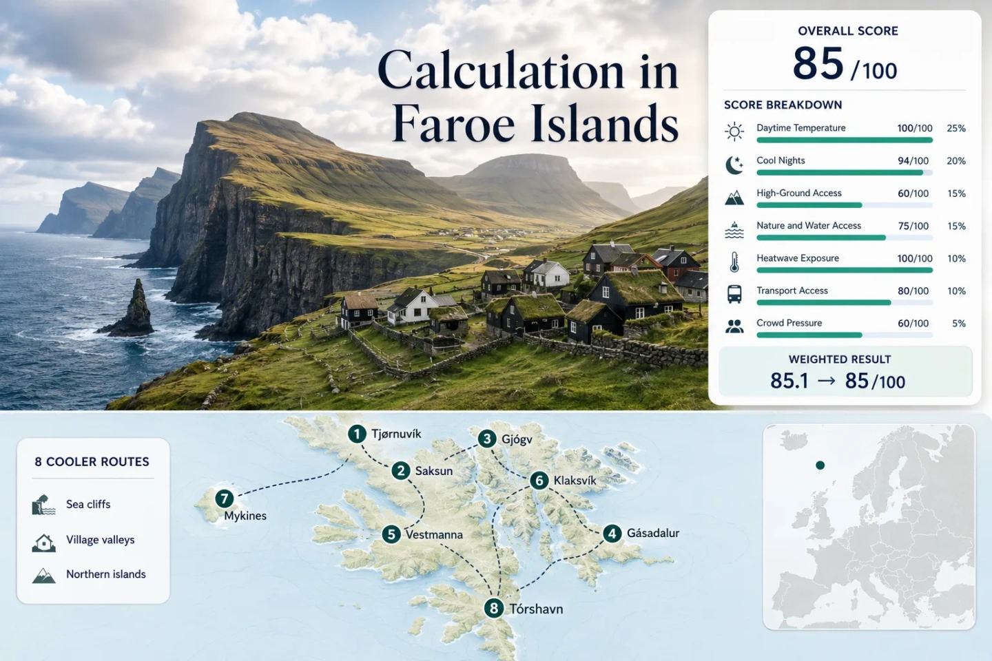
The markers connect northern valleys, tidal landscapes, western cliff routes, an outer-island ferry day and two service-rich town bases. The route numbers match the destination cards.
Markers show selected cooler-route regions and approximate public location centers, not guaranteed legal parking, trailheads or exact viewpoints. Check each route card for access notes and Google Maps links before travelling.
Faroe Islands North Atlantic Suitability Score
This transparent editorial suitability index uses disclosed climate, high-ground, water access, heat exposure, transport and capacity factors. It is not an official climate classification or a weather forecast.
Weighted total: 100×0.25 + 94×0.20 + 60×0.15 + 75×0.15 + 100×0.10 + 80×0.10 + 60×0.05 = 85.1 → 85/100
Method: Route count does not add bonus points. Route-level values are combined using the median before the fixed weights are applied. The B comparability grade reflects one common representative climate station, mixed categorical access evidence and an official threshold-frequency fallback rather than eight direct station series.
Northern Valleys, Western Cliffs and Road-Connected Town Bases
The portfolio separates easy tunnel-linked bases from narrow village roads and a weather-dependent outer-island ferry. The climate values remain comparable, while the practical trade-offs come from shelter, road geometry, bus frequency and booking rules.
Tjørnuvík and the North-Facing Bay
A steep amphitheatre of mountains opens directly to the North Atlantic, so the village combines immediate sea air with strong wind-channel effects. The common official climate proxy gives 13.1°C average daytime maxima and 9.2°C average minima for July–August; station 601100 lies about 36 km away.
Saksun’s Tidal Lagoon and Enclosed Valley
The July–August representative values are 13.1°C by day and 9.2°C at night from station 601100, approximately 33 km away. The Langasandur approach crosses a documented 373–505 m elevation band, while the village itself sits inside a sheltered bowl above the tidal water system.
The lagoon can look calm while the exposed approach remains windy, so walking conditions should be judged separately from the view at the church and farm area.
Gjógv’s Gorge, Sea Exposure and Request Bus
Gjógv places a compact village beside a natural sea-filled gorge, with northern Eysturoy ridges rising immediately behind it. The shared climate mapping is 13.1°C maximum and 9.2°C minimum, with the representative station about 35 km away.
Several route 201 departures require a telephone request at least two hours before travel. That keeps the village possible without a car, but it is less flexible than Klaksvík or Tórshavn when the weather window changes late in the day.
Gásadalur Beyond the Vágar Tunnel
Seasonal public transport is the defining metric. The 2026 route 350 timetable provides weekday Tórshavn–Gásadalur service during the main summer period, while the road tunnel keeps the village connected when walking over the old pass is unsuitable.
Station 601100 is approximately 36 km away; the common July–August values are 13.1°C and 9.2°C. The village center is modestly higher than the station, and the surrounding paths climb steeply toward the crest between Árnafjall and Eysturtind.
Vestmanna Harbour and the Sea-Cliff Weather Window
Vestmanna itself is one of the easier car-light bases: route 100 links it with Tórshavn, and the representative climate station is about 26 km away with a similar coastal elevation. July–August normals remain 13.1°C by day and 9.2°C at night.
The cliff experience is a separate decision from reaching town. Harbour access may be straightforward while the boat route remains wind- and sea-state dependent. A cancelled sailing still leaves a usable village and west-Streymoy road day.
Klaksvík as a Northern-Islands Weather Base
Regular route 400 buses and tunnel connections make Klaksvík the strongest northern car-light base in the set. The Tórshavn station proxy is approximately 24 km away and gives 13.1°C average maxima and 9.2°C average minima for the target window.
Urban services reduce booking friction compared with the smallest villages, but Kalsoy ferry capacity should be treated as a separate booked excursion rather than part of an open-ended driving day.
Mykines as a Booked Ferry Day
The common station mapping is the least direct in the portfolio: Tórshavn station 601100 is about 47 km from the island center and cannot represent every exposed slope. It supplies a comparable 13.1°C maximum and 9.2°C minimum baseline, but local wind, fog and sea state carry more uncertainty here than on the tunnel-linked routes.
Tórshavn for Flexible North Atlantic Days
The official climate station is only about 2 km from the city center, making this the sole near-direct climate match in the route set. July’s 12.9°C and August’s 13.3°C mean maxima average 13.1°C; corresponding minima average 9.2°C.
Tórshavn does not deliver the same exposed-village atmosphere as Tjørnuvík or Mykines, but it offers the highest recovery value when wind closes a boat route or fog removes a western viewpoint. The difficult 6 km Syðradalur path also gives a summer-only upland option from the capital area.
Tunnel-Connected Days and Ferry-Dependent Days
The archipelago’s short map distances hide three different commitment levels. Road tunnels permit rapid substitutions, request buses need earlier decisions, and outer-island ferries can turn a whole day into a single weather bet.
Tórshavn, Klaksvík and Vestmanna Keep Options Open
Tórshavn and Klaksvík sit on the main road-and-tunnel spine, while Vestmanna has regular bus access. A morning forecast change can redirect the day without losing a ferry reservation or waiting for a request-only departure.
Gjógv, Gásadalur and Tjørnuvík Need Timetable Reading
Gjógv combines route 400 with route 201 and request conditions; Gásadalur’s route 350 is summer and weekday oriented; Tjørnuvík’s published service is much less dependable for a July–August visitor. These villages work better when transport is checked before the weather choice is finalized.
Mykines Is a Single-Purpose Booking
The 45-minute crossing, limited summer season, fee structure and sea-condition exposure make Mykines qualitatively different from the road network. Do not pair it with a fixed late-afternoon village plan on another island.
Eight Routes Compared by Access, Exposure and Recovery Value
All eight assessed routes are retained so the practical comparison matches the score and marker map. “Recovery value” measures how easily the day can be redirected after a weather or capacity problem.
| Route | Car-light access | Main cooling mechanism | Main constraint | Recovery value |
|---|---|---|---|---|
| Tjørnuvík | Low in July–August | North-facing bay and channelled wind | Limited bus pattern and end-of-road parking | Medium; Saksun or east-Streymoy roads require a reset |
| Saksun | None | Enclosed valley, lagoon air and nearby uplands | Private car and concentrated visitor parking | Medium; Tjørnuvík and Hvalvík remain road alternatives |
| Gjógv | Moderate | Open gorge, ocean inlet and immediate ridges | Connections and request departures | High when based in Klaksvík or central Eysturoy |
| Gásadalur | Moderate on summer weekdays | Western ocean air and steep valley walls | Fog, limited bus departures and exposed paths | High; Bøur, Sørvágur and Tórshavn are road-linked |
| Vestmanna Sea Cliffs | High to the harbour | West-coast wind and open-water exposure | Boat capacity and sea state | High; the town and Streymoy road network remain usable |
| Klaksvík | High | Northern sounds, town breezes and nearby high ground | Kalsoy ferry capacity for island extensions | Very high; several road and trail alternatives start nearby |
| Mykines | Low | Outer-ocean exposure and treeless uplands | Booked seasonal ferry, fee and weather cancellation | Low after departure; high only before committing at Sørvágur |
| Tórshavn | Very high | Harbour air and cool official station baseline | Less dramatic exposure than outer villages | Very high; main bus, ferry and road interchange |
Fog and Wind Do Not Affect Every Island Zone Equally
Vágar Can Stay Drivable After the View Disappears
Gásadalur’s tunnel connection may remain open while low cloud removes the waterfall, cliff edge and mountain crest from view. A Vágar day should therefore include a lower, road-based alternative rather than treating visibility loss as a reason to wait indefinitely at the same viewpoint.
Northern Streymoy Turns Wind Direction into a Route Choice
Tjørnuvík faces north into an open bay, Saksun sits inside a deep valley, and Vestmanna opens west toward the sea cliffs. These three routes are geographically close but can produce different shelter, gust and cloud behaviour on the same day.
Klaksvík Supports a Fast Shift Between Sides of the Mountains
The tunnel-linked town base allows a move between Klakkur, Borðoy roads and neighbouring northern-island viewpoints without committing to a ferry. That flexibility matters more than chasing a single “sunny” forecast symbol for the whole archipelago.
Late Summer Light, Cool Nights and Sleep Planning
Long northern daylight extends usable evening time, but the temperature baseline remains cool. A late arrival in Tórshavn or Klaksvík can still support a harbour walk or short town-based route, while exposed village paths should not be extended simply because the sky remains bright.
Road-Connected Evenings
Tórshavn, Klaksvík and Vestmanna allow a flexible late-day outing without tying the return to a single ferry departure. They are practical after a daytime route is shortened by fog.
Cool Rooms Can Still Need Light Control
The 9.2°C representative night minimum supports strong natural cooling, but long light can interfere with sleep. Blackout curtains may matter more than mechanical cooling.
Set a Weather Cutoff Before a Cliff Walk
Brightness is not a safety proxy. Wind, wet grass, fog and return transport should set the turnaround time for Mykines, Gásadalur and sea-cliff routes.
One Priority Route and One Road-Connected Alternative
Faroe Islands distances are short, but the operational risks are concentrated: fog can erase a western view, wind can stop a boat, and a limited bus can remove the return option. Build each day around one primary route and one tunnel- or road-connected alternative. Reserve Mykines and sea-cliff boat days separately, confirm the latest public-transport and path information, and avoid treating a bright sky in one village as an archipelago-wide forecast.