Austria in Summer: Lake Towns, Alpine Valleys and Mountain Shade
Austria’s more heat-resilient summer bases sit where high settlement elevations, swimmable lakes, forested slopes and rail-accessible Alpine valleys overlap. The seven routes assessed here range from Obergurgl at 1,941 metres to the lake districts of Achensee, Ausseerland and Weissensee, with July–August climate normals that make cooler nights and rapid access to higher ground part of the daily plan rather than an occasional excursion.
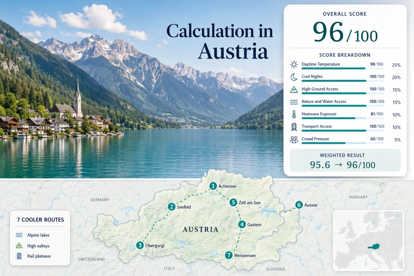
The map, score, route cards and comparison table use the same seven destinations.
Median July–August mean daily maximum across seven GeoSphere Austria stations.
Cool nights remain a major advantage even where lake-level afternoons become warm.
Its July–August mean daily maximum is 16.7°C, with a mean minimum of 6.7°C.
Seefeld, Bad Gastein, Zell am See and Bad Aussee have rail stations at the destination base.
Zell am See and Bad Aussee need earlier starts or higher-ground backup during hot spells.
Austrian Lake Towns and High-Valley Bases
The numbered markers connect Tyrol, Salzburg, Styria and Carinthia through the same destinations used in the suitability score. Marker positions are planning centres rather than guaranteed trailheads, legal parking points or exact viewpoints.
Use the Google Maps link in each route card for current access and navigation. Mountain roads, lift stations, shuttle stops and lakeside parking arrangements can differ from the planning marker.
Austria Lake and Alpine Valley Suitability Score
This transparent editorial suitability index uses disclosed climate, landscape, access and pressure factors. It is not an official climate classification or a weather forecast, and it represents only the seven routes shown on the map.
Method: Median of each direct station’s July–August mean daily maximum, followed by fixed linear normalization.
Route values: Achenkirch 21.5°C; Seefeld 20.5°C; Obergurgl 16.7°C; Bad Gastein 21.3°C; Zell am See 23.0°C; Bad Aussee 22.8°C; Weissensee 21.8°C.
Raw: 21.45°C. The scale gives 100 at 21°C and 90 at 23°C, producing 97.8 before display rounding.
Source mapping: Achenkirch, Seefeld, Obergurgl, Bad Gastein, Zell am See, Bad Aussee and Weissensee are direct named-station mappings for the scored base. Station codes are not published in the cited workbook; mapping distance and elevation difference are treated as 0 km and 0 m at each named station base. Kaprun, Altaussee and the wider lake zones are associated excursion areas rather than separate climate inputs.
Period: GeoSphere Austria climate normals, 1991–2020; the cited station selection required at least 95% daily coverage for the normal period.
Sources: GeoSphere Austria climate normals documentation and official 1991–2020 station workbook.
Method: Median of each direct station’s July–August mean daily minimum, then application of the fixed night-cooling scale.
Route values: Achenkirch 10.5°C; Seefeld 9.0°C; Obergurgl 6.7°C; Bad Gastein 10.2°C; Zell am See 10.4°C; Bad Aussee 11.9°C; Weissensee 11.5°C.
Raw: 10.35°C. The fixed comfort band assigns 100/100 to a median between 10°C and 16°C.
Source mapping: The same seven direct named stations used for daytime temperature are used here; station codes are not published in the cited workbook.
Period: 1991–2020 July–August climate normals.
Sources: GeoSphere Austria normal-period notes and official station workbook.
Method: Fixed elevation and access rubric applied to every route, followed by the route-score median.
Route scores: Achenkirch 100 — 931 m base; Seefeld 100 — 1,182 m; Obergurgl 100 — 1,941 m; Bad Gastein 100 — 1,092 m; Zell am See 80 — 754 m with regular lift access toward almost 2,000 m; Bad Aussee 80 — 743 m with surrounding high-ground access; Weissensee 100 — 949 m.
Raw: 100/100. Route count provides no bonus.
Route rationale: Scores follow the fixed base-elevation and reachable-high-ground thresholds, supported by station metadata and current lift access.
Period: Station elevations from 1991–2020 metadata; lift and destination access reviewed July 15, 2026.
Sources: GeoSphere Austria station elevations, Gurgl Hohe Mut summer operation, and Schmittenhöhebahn access information.
Method: Fixed physical-access rubric measuring whether a major lake, broad forest belt or comparable water system is reachable within 30 or 60 minutes.
Route scores: Achenkirch 100 — Achensee plus Karwendel forest access; Seefeld 75 — extensive forest and plateau lakes; Obergurgl 45 — strong high-alpine setting but limited large-water and forest access; Bad Gastein 75 — forested valley and river-gorge access; Zell am See 100 — Lake Zell plus forested slopes; Bad Aussee 100 — Altaussee, Grundlsee and forest belts; Weissensee 100 — large lake and nature-park forest.
Raw: 100/100. Scenic quality is not scored; only practical physical access is considered.
Route rationale: Each score reflects the number and travel time of strong forest, lake or river systems accessible from the overnight base.
Period: Current destination and transport access reviewed July 15, 2026.
Sources: Achensee regional access, Zell am See lake and mountain services, and Weissensee lake transport.
Method: Official threshold-frequency fallback. GeoSphere Austria’s normal number of 30°C-or-warmer days in July and August was divided by 62 calendar days for each station; route percentages were then reduced to the median and normalized.
Route values: Achenkirch 2.4 days, 3.9%; Seefeld 0.6 days, 1.0%; Obergurgl 0.0 days, 0.0%; Bad Gastein 2.1 days, 3.4%; Zell am See 7.0 days, 11.3%; Bad Aussee 6.4 days, 10.3%; Weissensee 3.2 days, 5.2%.
Raw: 3.87%. Linear interpolation between 2% = 90 and 5% = 75 gives 80.6 before display rounding.
Source mapping: Each route uses the same direct named station as the daytime and night factors. Station codes are not published in the cited workbook; the scored base is mapped at 0 km and 0 m difference, with Kaprun and Altaussee retained as associated excursion areas rather than separate station inputs.
Coverage: This factor does not claim an exact latest-ten-summer daily count. The official climatological threshold-frequency fallback uses the complete 1991–2020 normal-period station product; the station-selection documentation requires at least 95% daily coverage over that period.
Period: 1991–2020, July–August.
Sources: GeoSphere Austria coverage and normal methodology and official hot-day station values.
Method: Fixed public-transport rubric applied route by route, then reduced to the median.
Route scores: Achenkirch 80 — rail to Jenbach plus a roughly 25-minute regional bus; Seefeld 100 — station and bus terminal at the town centre; Obergurgl 80 — rail to Ötztal Bahnhof plus scheduled valley bus; Bad Gastein 100 — direct rail and Regionalbus 550; Zell am See 100 — direct rail plus regional mobility network; Bad Aussee 100 — R70 rail and connecting bus; Weissensee 80 — Greifenburg rail plus advance-reservation station shuttle.
Raw: 100/100. Private-car convenience is not treated as an extra bonus.
Route rationale: Direct scheduled rail and local transit score 100; a simple rail-to-bus or reserved-shuttle transfer within the fixed rubric scores 80.
Period: Services and access rules reviewed July 15, 2026; individual timetables remain date-specific.
Sources: Achensee arrival information, Seefeld mobility network, Gastein Regionalbus service, and Weissensee station shuttle.
Method: Fixed categorical fallback using official peak-period restrictions, reservation requirements, shuttle capacity and attraction-access rules because route-level accommodation occupancy was not available on a directly comparable basis.
Route scores: Achenkirch 60 — regular summer demand with finite bus and lake-service capacity; Seefeld 60 — regular peak pressure around plateau services; Obergurgl 80 — no broad route-wide reservation requirement; Bad Gastein 60 — concentrated lift and valley-bus demand; Zell am See 40 — multiple Summer Card peak-window restrictions from July 15 to September 15; Bad Aussee 60 — recurring lake and access pressure without a route-wide mandatory reservation; Weissensee 60 — advance shuttle reservation and managed lakeside mobility.
Raw: 60/100. This is a categorical planning signal, not an accommodation-occupancy percentage.
Route rationale: The categories use visible 2026 operating restrictions, reservation deadlines, managed mobility and attraction-access rules as comparable pressure signals.
Period: Current 2026 operating and access information reviewed July 15, 2026.
Sources: Zell am See-Kaprun peak-window card restrictions, Weissensee reservation rules, Gurgl 2026 lift window, and Statistics Austria tourism framework.
Weighted total: 98×0.25 + 100×0.20 + 100×0.15 + 100×0.15 + 81×0.10 + 100×0.10 + 60×0.05 = 95.6 → 96/100
Lake Shores, Rail Plateaus and High Alpine Bases
Each route combines a measured station base with a distinct way to manage afternoon heat: immediate water access, shaded woodland, high settlement altitude or a short public-transport connection to higher terrain.
Achenkirch and Achensee
Achensee supplies the water-side option while Achenkirch’s elevation keeps the climate base far above the Inn Valley floor. Jenbach is the rail gateway, and the official regional connection reaches the lake in roughly 25 minutes.
The route works well when swimming, lakeside walking and Karwendel forest shade matter as much as summit access. Warm, exposed shore sections still benefit from an early start.
Seefeld Plateau
Seefeld pairs a high plateau with a station beside the pedestrian centre. The regional network includes three train stations, 77 bus stops and summer services toward Wildmoos and Gaistal, giving car-light access to forest and meadow routes.
The normal July–August hot-day frequency is only 0.6 days, equivalent to about 1.0% of the two-month window. Midday sun can still be strong on open plateau paths, while wooded Leutasch and Gaistal provide the more reliable shade pattern.
Open Seefeld Plateau in Google MapsObergurgl
Altitude is the primary cooling mechanism. The official station sits at 1,941 m, where the July–August mean daily maximum is 16.7°C and the mean minimum is 6.7°C. The 1991–2020 normal records no 30°C days in either target month.
Obergurgl is less lake-oriented than the other routes, but it supplies the clearest low-heat base. In 2026, Hohe Mut summer operation is scheduled from July 15 to September 13, so early-July plans should not assume the same lift network as late July.
Bad Gastein
Bad Gastein places a railway station, steep forested slopes and a high valley in the same base. Its July–August mean daily maximum is 21.3°C, the mean minimum is 10.2°C, and the normal two-month total is 2.1 hot days.
Regionalbus 550 runs every 15 minutes between Dorfgastein, Bad Hofgastein, Bad Gastein and Sportgastein, making elevation shifts possible without rebuilding the day around parking.
Zell am See and Kaprun
Lake Zell supports swimming and shoreline time, while Schmittenhöhe and the Kaprun side provide rapid vertical escape. The Zell am See station normal is warmer than the route-set median: 23.0°C by day, 10.4°C at night and 7.0 normal hot days across July and August.
The Summer Card runs from May 15 to October 31 at participating accommodation, but July 15–September 15 includes arrival-day and attraction-use restrictions. That peak window should be checked before building a tightly timed lift-and-lake itinerary.
Open Zell am See and Kaprun in Google MapsBad Aussee and Altaussee
Bad Aussee is the rail base for a lake network that includes Altausseer See and nearby Grundlsee. The climate station records 6.4 normal hot days across July and August, so the route is cooler through water, shade and night relief rather than consistently low afternoon temperatures.
R70 trains serve Bad Aussee, while regional buses continue toward Altaussee. The arrangement suits travellers who want a town base with several water-and-forest alternatives rather than one fixed lakeshore.
Weissensee
Weissensee combines a 949 m station base, a large swimming lake and a forested nature-park setting. The July–August mean daily maximum is 21.8°C, the mean minimum is 11.5°C and the normal hot-day total is 3.2 days.
The nature-park bus and lake boat services support a low-car stay, but the timetable is the structure of the trip rather than a background convenience. The lake can warm enough for swimming while shaded north-shore and forest routes remain the stronger midday option.
Open Weissensee in Google MapsLake Water and Alpine Altitude Solve Different Heat Problems
Austria’s summer comfort is strongest when the route choice matches the expected type of heat rather than treating every Alpine destination as interchangeable.
Achensee, Ausseerland and Weissensee for Water-Led Days
These routes place swimming, boats or shoreline walking close to the accommodation base. Their daytime normals range from 21.5°C to 22.8°C, so water access improves the day without guaranteeing a cool afternoon. Early shore time followed by forest shade is the more dependable sequence.
Obergurgl, Seefeld and Bad Gastein for Cooler Nights
Settlement elevation changes both afternoon and overnight conditions. Obergurgl’s 16.7°C daytime normal is the clearest low-heat result, while Seefeld and Bad Gastein retain rail or bus convenience with mean July–August nights near 9–10°C.
Zell am See and Kaprun for a Split-Level Itinerary
Zell’s station normal is the warmest in the set, but the route can shift from lake level to almost 2,000 m on Schmittenhöhe. It is more resilient when high-ground access is planned before the hot day arrives rather than added after the lakeshore becomes uncomfortable.
Seven Austrian Bases by Heat, Night Relief and Car Dependence
The climate columns use the same direct station values as the score. Access descriptions separate destination-base rail from last-mile bus or shuttle dependence.
| Route | Base elevation | July–August mean max | July–August mean min | 30°C+ normal share | Public-transport pattern |
|---|---|---|---|---|---|
| Achenkirch and Achensee | 931 m | 21.5°C | 10.5°C | 3.9% | Jenbach rail + about 25-minute bus |
| Seefeld Plateau | 1,182 m | 20.5°C | 9.0°C | 1.0% | Direct rail + dense regional bus network |
| Obergurgl | 1,941 m | 16.7°C | 6.7°C | 0.0% | Ötztal Bahnhof rail + valley bus |
| Bad Gastein | 1,092 m | 21.3°C | 10.2°C | 3.4% | Direct rail + 15-minute valley bus frequency |
| Zell am See and Kaprun | 754 m | 23.0°C | 10.4°C | 11.3% | Direct rail + buses and lift network |
| Bad Aussee and Altaussee | 743 m | 22.8°C | 11.9°C | 10.3% | R70 rail + regional bus to Altaussee |
| Weissensee | 949 m | 21.8°C | 11.5°C | 5.2% | Greifenburg rail + reserved station shuttle |
Rail Valleys, Plateau Stations and the Last Connection
Austria’s national rail network makes several cooler bases unusually practical, but the final 10–30 kilometres determine whether a route remains flexible during a warm afternoon.
Four Bases With a Station at the Destination
Seefeld, Bad Gastein, Zell am See and Bad Aussee allow arrival at the overnight base without a road transfer. Seefeld’s station sits by the pedestrian centre, while Bad Gastein and Zell am See connect onward movement to local buses and lifts.
Achenkirch and Obergurgl Depend on a Timed Valley Link
Achensee uses Jenbach as the hub, with the lake about 25 minutes away by bus. Obergurgl requires the longer Ötztal valley connection, but the high settlement altitude means the transfer ends at the cooling zone rather than at a lower gateway town.
Weissensee Requires a Reservation Mindset
The Greifenburg station shuttle reaches accommodation from the rail line, but reservations are required by the previous evening for the standard overnight-guest service. A missed booking changes the arrival plan more sharply than at the direct-rail bases.
The 2026 Lift Calendar Changes the Mountain-Shade Strategy
Lake access is comparatively stable through summer, while the strongest high-ground backup depends on operating dates, weather holds and peak-period rules.
Late June to Mid-July
Bad Gastein and Zell am See already have broad summer operations, while Obergurgl should not be planned around Hohe Mut access before July 15. Lower trails, gorges and lake mornings carry more of the cooling workload.
July 15 to September 13
This is the broadest shared lift window across the assessed high routes. It also overlaps the July 15–September 15 Zell am See-Kaprun Summer Card restrictions, making advance sequencing more important during the busiest weeks.
Mid-September into October
Night cooling strengthens and lake swimming becomes less dependable. Schmittenhöhe continues into autumn, while some high-valley lifts and huts move to reduced schedules or close, so walking access and return transport need a same-day check.