Czechia for Mild Summer Breaks: Hill Towns, Forest Parks and Historic Cities
Czechia’s mildest summer routes combine upland forests, cooler nights and compact historic towns. Šumava and Krkonoše provide the clearest elevation advantage, while Telč, Český Krumlov, Třeboň and Znojmo work through early old-town hours, shaded park access and slower evenings away from exposed squares.
The route set covers mountain towns, sandstone parks, South Bohemian ponds and three distinct historic-city patterns.
A town elevation near 770 m and quick access to higher Krkonoše terrain produce the strongest daytime and overnight cooling signal.
A hill-town base around 758 m places broad Šumava forest cover close to accommodation, walking routes and evening services.
Direct rail services and regional connections make the town easier to combine with the Vltava corridor and Blanský Forest.
South Moravia carries greater heatwave exposure, so shaded Dyje Valley time matters more than elevation at this base.
Bohemian Switzerland closures, Krkonoše access rules and pressure around famous old towns can change the practical route.
Šumava Forests, Sandstone Parks and Historic-Town Bases
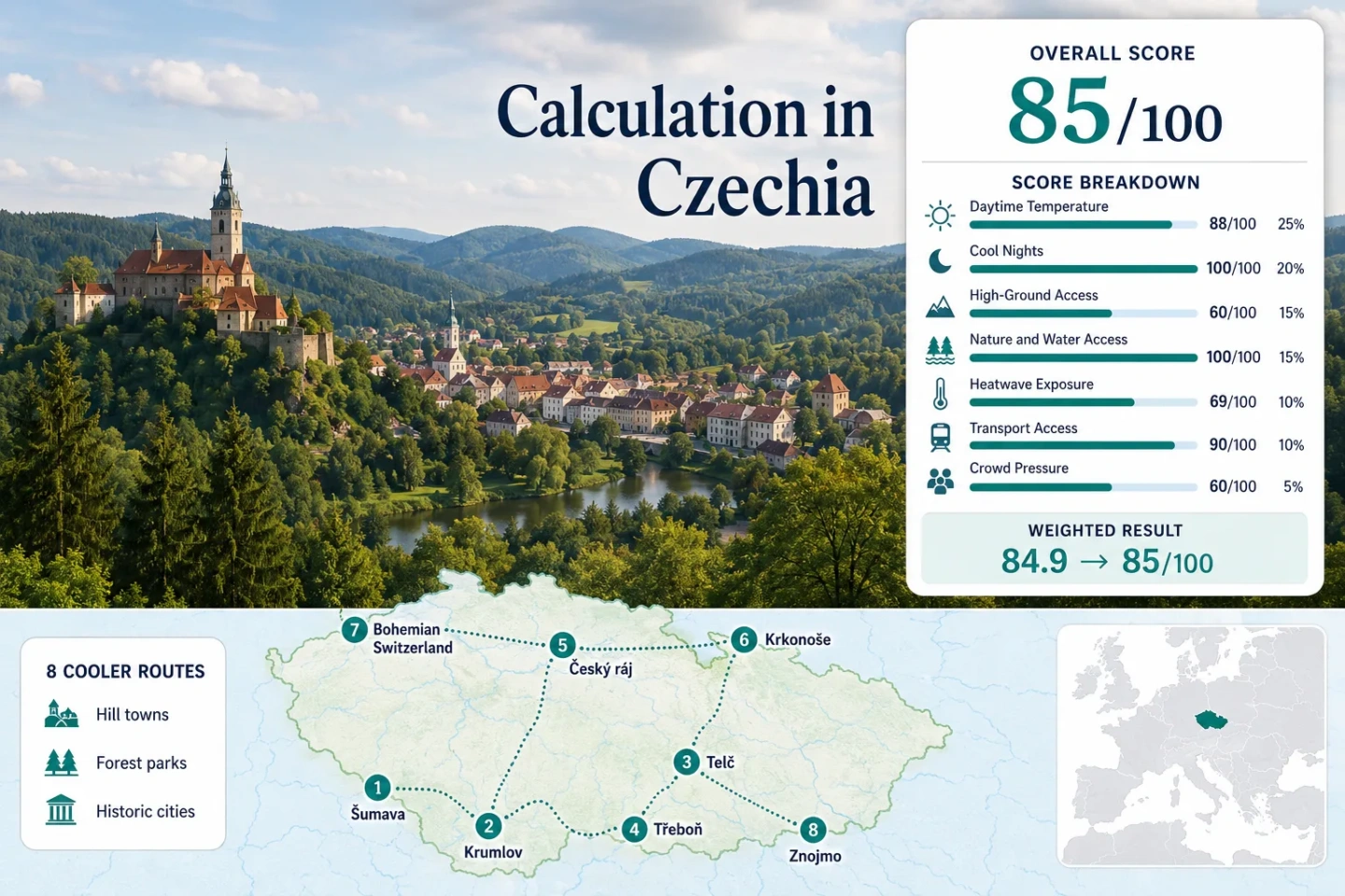
The marker pattern stretches from Šumava’s south-western uplands to the Krkonoše ridge zone, with pond country, sandstone terrain and heritage towns filling the lower-altitude gaps between them.
Markers show selected route centers for planning orientation, not exact viewpoints, legal parking areas or trailheads. Current park notices and local access information should be checked before travel.
Czechia Mild-Summer Escape Suitability Score
This transparent editorial suitability index uses disclosed climate, landscape, access and peak-pressure factors. It is not an official climate classification, a destination guarantee or a weather forecast.
Czechia scores strongly because the route portfolio combines cool nights, extensive forest access and workable public transport. The lower mountain-access median and warm South Moravian route prevent the result from behaving like a purely highland score.
Method: Common route-center model-grid proxy, using July and August mean daily maximum temperature. Values are rounded to 0.5°C to avoid implying station-level precision.
Raw: Route median 23.25°C. The fixed normalization curve gives 90/100 at 23°C and 75/100 at 25°C; linear interpolation produces approximately 88/100.
Route values: Šumava and Kašperské Hory 20.5°C; Český Krumlov and Blanský Forest 23.5°C; Telč and the Vysočina Highlands 22.5°C; Třeboň and the South Bohemian Ponds 24.0°C; Český ráj and Turnov 23.5°C; Krkonoše and Pec pod Sněžkou 19.0°C; Bohemian Switzerland and Jetřichovice 23.0°C; Podyjí and Znojmo 26.0°C. Median: 23.25°C.
Source mapping: All eight values use the listed route-center coordinates as gridded planning proxies rather than direct town stations. Mountain and basin microclimates can differ materially within the same grid cell.
Period: July–August monthly climatology for 1991–2020.
Sources: NASA POWER Monthly and Annual API documentation; Czech Hydrometeorological Institute 2024 climatological yearbook.
Method: Common route-center model-grid proxy, using July and August mean daily minimum temperature. The score measures recurring overnight relief rather than record-low temperatures.
Raw: Route median 13.0°C. The fixed comfort band awards 100/100 for a median between 10°C and 16°C.
Route values: Šumava and Kašperské Hory 9.5°C; Český Krumlov and Blanský Forest 13.0°C; Telč and the Vysočina Highlands 12.0°C; Třeboň and the South Bohemian Ponds 13.5°C; Český ráj and Turnov 13.0°C; Krkonoše and Pec pod Sněžkou 9.0°C; Bohemian Switzerland and Jetřichovice 13.0°C; Podyjí and Znojmo 15.0°C. Median: 13.0°C.
Source mapping: Route centers use the same model grid and period as the daytime factor. Inversions, exposed ridges, dense old-town fabric and local valley drainage can produce colder or warmer individual nights.
Period: July–August monthly climatology for 1991–2020.
Sources: NASA POWER monthly meteorological data documentation; Czech Hydrometeorological Institute territorial temperature data.
Method: Fixed categorical high-ground rubric applied to each accommodation base and the realistically accessible terrain within approximately 60 minutes.
Raw: Median route score 60/100.
Route scores: Šumava and Kašperské Hory 100 — base near 758 m with regular access to terrain above 1,000 m; Český Krumlov and Blanský Forest 60 — base near 492 m with Kleť rising to 1,084 m nearby; Telč and the Vysočina Highlands 60 — base near 514 m with meaningful upland countryside but no major mountain belt; Třeboň and the South Bohemian Ponds 30 — base near 434 m with limited relief; Český ráj and Turnov 60 — low town base with accessible sandstone uplands and hill routes; Krkonoše and Pec pod Sněžkou 100 — base near 769 m with cable-car and trail access above 1,000 m; Bohemian Switzerland and Jetřichovice 60 — low village base with strong local relief but modest absolute altitude; Podyjí and Znojmo 30 — river-valley relief without a high-ground zone. Median: 60/100.
Route rationale: The score rewards practical elevation access, not distant mountains visible from the route or scenic quality alone.
Period: Access conditions reviewed 15 July 2026.
Sources: Šumava National Park visitor information; Krkonoše National Park tundra trail access; Bohemian Switzerland National Park safety and route information.
Method: Fixed physical-access rubric. A route receives 100 when at least two strong elements—extensive forest, a major lake or river system, or coastline—are reachable within approximately 30 minutes.
Raw: Median route score 100/100.
Route scores: Šumava and Kašperské Hory 100 — extensive forest plus Otava headwater landscapes; Český Krumlov and Blanský Forest 100 — Vltava River plus broad forest access; Telč and the Vysočina Highlands 100 — immediate ponds plus wooded uplands; Třeboň and the South Bohemian Ponds 100 — major pond system, wetlands and forest belts; Český ráj and Turnov 100 — sandstone forests plus the Jizera river system; Krkonoše and Pec pod Sněžkou 100 — extensive mountain forest plus Úpa headwaters; Bohemian Switzerland and Jetřichovice 100 — forested sandstone valleys plus the Kamenice and nearby Elbe system; Podyjí and Znojmo 100 — Dyje River canyon plus protected forest. Median: 100/100.
Route rationale: The factor measures usable physical access and does not award points for aesthetic reputation.
Period: Access conditions reviewed 15 July 2026.
Sources: Šumava National Park Kašperské Hory information; Krkonoše National Park visiting regulations; Bohemian Switzerland National Park visitor safety information.
Method: Proxy Dataset calculation using route-center daily maximum temperature and a 30°C threshold. Percentages are rounded planning estimates from a common model grid and are not direct station counts.
Raw: Median estimated threshold frequency 6.5%. The fixed scale gives 75/100 at 5% and 55/100 at 10%; interpolation produces 69/100.
Route values: Šumava and Kašperské Hory 2%; Český Krumlov and Blanský Forest 8%; Telč and the Vysočina Highlands 6%; Třeboň and the South Bohemian Ponds 8%; Český ráj and Turnov 7%; Krkonoše and Pec pod Sněžkou 1%; Bohemian Switzerland and Jetřichovice 6%; Podyjí and Znojmo 15%. Median: 6.5%.
Source mapping: Route-center grid coordinates are 49.1434, 13.5562; 48.8127, 14.3175; 49.1842, 15.4543; 49.0036, 14.7707; 50.5873, 15.1568; 50.6935, 15.7334; 50.8527, 14.3937; and 48.8555, 16.0488. Modeled calendar coverage is 620/620 July–August days for each route center; this indicates grid continuity, not direct weather-station completeness.
Period: 1 July–31 August for the ten completed summers from 2016 through 2025; 620 calendar days assessed at each grid center.
Sources: NASA POWER Daily API documentation; Czech Hydrometeorological Institute 2024 climatological yearbook; Czech Hydrometeorological Institute review of 2025 conditions.
Method: Fixed categorical transport rubric based on regular rail or bus access to the accommodation base. Trailhead convenience does not replace access to the base itself.
Raw: Median route score 90/100.
Route scores: Šumava and Kašperské Hory 80 — regional bus access from rail-connected towns, with some forest locations remaining car-dependent; Český Krumlov and Blanský Forest 100 — direct rail and regional transport, with a car useful but not essential; Telč and the Vysočina Highlands 80 — town railway station and buses, though some rural connections are slow; Třeboň and the South Bohemian Ponds 100 — direct rail access and flat local movement; Český ráj and Turnov 100 — major regional rail junction with onward buses and local trains; Krkonoše and Pec pod Sněžkou 80 — regular bus access from Trutnov, followed by local mountain transport; Bohemian Switzerland and Jetřichovice 60 — bus-dependent park access with closures affecting route choice; Podyjí and Znojmo 100 — direct rail and bus access to the city, with local links toward the park. Median: 90/100.
Route rationale: Scores reflect arrival without a private vehicle. Reaching remote viewpoints, peatlands or minor trailheads can require additional transfers.
Period: Timetable and visitor-access structure reviewed 15 July 2026.
Sources: České dráhy journey and timetable information; Direct Prague–Český Krumlov train example; Šumava regional railway example; National public-transport journey planner.
Method: Categorical rubric based on current official visitor-management information, access restrictions, parking or transport pressure and the concentration of demand at major landmarks. Comparable route-level accommodation occupancy was not available for all eight locations.
Raw: Median route score 60/100.
Route scores: Šumava and Kašperské Hory 80 — weekend pressure at selected access points but broad route dispersion; Český Krumlov and Blanský Forest 40 — concentrated old-town demand and early booking pressure; Telč and the Vysočina Highlands 80 — moderate seasonal demand without widespread capacity controls; Třeboň and the South Bohemian Ponds 80 — spa and cycling demand, generally dispersed across the basin; Český ráj and Turnov 60 — regular weekend pressure at major rock-town trailheads; Krkonoše and Pec pod Sněžkou 40 — concentrated resort, cable-car, trail and parking demand; Bohemian Switzerland and Jetřichovice 40 — closures funnel visitors toward fewer available routes; Podyjí and Znojmo 80 — city capacity and multiple park approaches reduce concentrated pressure. Median: 60/100.
Route rationale: This factor measures planning friction rather than total visitor popularity. A famous town can remain manageable when visits are shifted to early morning or weekday periods.
Period: Current official operating and visitor information reviewed 15 July 2026.
Sources: Bohemian Switzerland closures and safety notices; Krkonoše visiting and vehicle-access regulations; Šumava Poledník capacity information.
Weighted total: 88×0.25 + 100×0.20 + 60×0.15 + 100×0.15 + 69×0.10 + 90×0.10 + 60×0.05 = 84.9 → 85/100
Each route has equal weight. Route count does not create a bonus, and each factor uses the median of the eight route values or route scores.
Hill Towns, Pond Landscapes and Forest-Park Routes
The portfolio separates genuinely upland bases from historic towns whose summer comfort depends on water, shade, morning timing and quick access to protected landscapes.
Šumava and Kašperské Hory
Kašperské Hory provides the clearest forest-town match for the title. The elevated settlement sits beside the broad Šumava landscape, while nearby roads and paths reach peatlands, river headwaters and higher villages without requiring a resort-scale base.
The July–August route-center proxy is approximately 20.5°C by day and 9.5°C at night. Regional buses connect the town with Sušice and other transport points, although remote forest starts still reward careful timetable planning or a car.
Český Krumlov and Blanský Forest
Český Krumlov’s old center sits around 492 m inside a tight Vltava bend. Its route-center proxy reaches roughly 23.5°C by day and 13.0°C at night, so the town is mild rather than reliably cool during settled summer weather.
A direct intercity service can cover Prague to Český Krumlov in about two and a half hours. Blanský Forest and Kleť provide the practical relief valve: old-town lanes are handled early, while wooded slopes and higher terrain carry the warmer part of the day.
Telč and the Vysočina Highlands
Telč occupies a softer highland position than South Moravian cities. The arcaded square is exposed to afternoon sun, but ponds border the historic center and wooded Vysočina countryside begins close to town.
The railway reaches Telč on a regional branch line, while buses provide additional links toward Jihlava and surrounding towns. Rural day trips become easier with a car, but the historic core, ponds and immediate walking routes remain usable without one.
Třeboň and the South Bohemian Ponds
Třeboň is a low-relief route at approximately 434 m. Its July–August proxy is around 24.0°C by day and 13.5°C at night, so water and shade change the experience more than altitude.
Rožmberk, Svět and the wider fishpond network support low-effort cycling and evening waterside movement. Flat terrain helps on calm days, but it also provides little protection from direct sun when paths cross open fields or pond embankments.
Český ráj and Turnov
Turnov sits near 260 m, yet it functions as a useful rail junction for the forested sandstone landscapes of Český ráj. The route-center proxy is approximately 23.5°C by day and 13.0°C at night.
Prachov Rocks, Hrubá Skála and smaller rock-town areas provide shade between formations, but stone stairs and exposed viewpoints become heat traps in direct afternoon sun. Regional trains and buses support several approaches, reducing dependence on one crowded car park.
Krkonoše and Pec pod Sněžkou
Pec pod Sněžkou has the lowest-heat climate signal in the selected set. Buses reach the town from Trutnov, while cable-car and marked-trail systems provide access to higher Krkonoše terrain.
KRNAP identifies a 5.5 km tundra educational route from Růžohorky with about 550 m of elevation change. The same exposed terrain that produces cooler conditions also increases wind, cloud, lightning and fast-weather risk.
Bohemian Switzerland and Jetřichovice
Jetřichovice is a low village base near 234 m, with a route-center proxy around 23.0°C by day and 13.0°C at night. Cooling comes from narrow forest valleys and terrain shade rather than high elevation.
Current park information identifies temporarily closed western routes and warns about falling trees associated with drought and bark-beetle damage. The national park also regulates access hours according to fire-risk conditions.
Podyjí and Znojmo
Znojmo sits near 290 m and carries the warmest climate profile in the portfolio: approximately 26.0°C by day and 15.0°C at night in the July–August route-center proxy.
The city remains valuable because the Dyje cuts a deep, wooded valley immediately below the historic center. Rail access is straightforward, while local buses, walking routes and short road transfers lead toward Podyjí National Park.
Where Czech Railways End and Park Logistics Begin
Czechia’s rail network makes several heritage towns easy to reach, but the final connection into protected landscapes separates genuinely car-light routes from town-only stays.
South Bohemian Branch Lines
Český Krumlov and Třeboň can be reached directly by rail, while Šumava’s local lines serve places such as Volary, Horní Planá and Železná Ruda. Kašperské Hory itself relies more heavily on regional buses and road connections.
Practical split: Český Krumlov and Třeboň suit rail-first short breaks; deeper Šumava itineraries need more timetable tolerance.
Turnov as a Sandstone Junction
Turnov’s railway role is stronger than its altitude. Multiple rail approaches and onward buses allow Český ráj walks to start from different points rather than forcing every day through one famous parking area.
This flexibility matters on sunny weekends, when pressure at Prachov Rocks or Hrubá Skála can be much higher than on less-publicized forest routes.
Bus Arrival, Cable-Car Ascent
Pec pod Sněžkou does not have a railway station, but regular bus access from Trutnov preserves a car-light route. Cable cars and tourist buses then shift visitors toward higher ground.
Higher access is not constant access: Wind, maintenance, storms and peak demand can change the planned ascent.
Why the Two Sandstone Regions Need Different Plans
Český ráj Has Multiple Entry Patterns
Český ráj spreads its sandstone formations, castles and forest routes across a wider inhabited landscape. Turnov, Jičín and smaller railway stops create several practical approaches.
Heat planning can therefore be flexible: a sunny viewpoint route can be exchanged for a wooded rock corridor without abandoning the whole region.
Bohemian Switzerland Is More Closure-Sensitive
Bohemian Switzerland’s post-fire management, falling-tree risk and closed western trails can funnel demand into fewer available corridors. Gabrielina stezka remains listed as unavailable in current park information.
Check the official notice on the morning of travel. Wind, fire danger and tree instability can matter as much as temperature.
Eight Routes Compared by Heat, Nights and Access
The daytime and night columns use the same rounded route-center proxy values used in the score. Access descriptions refer to the accommodation base rather than every trailhead.
| Route | July–August daytime proxy | Night proxy | Car-light access | Main cooling mechanism | Primary constraint |
|---|---|---|---|---|---|
| Šumava and Kašperské Hory | 20.5°C | 9.5°C | Workable by regional bus; remote starts are harder | Elevation and broad forest cover | Rural timetable gaps and storms |
| Český Krumlov and Blanský Forest | 23.5°C | 13.0°C | Strong town access by direct rail | Vltava corridor and nearby wooded altitude | Old-town crowd concentration |
| Telč and the Vysočina Highlands | 22.5°C | 12.0°C | Rail and bus access; rural loops take longer | Moderate elevation, ponds and open uplands | Exposed historic square at midday |
| Třeboň and the South Bohemian Ponds | 24.0°C | 13.5°C | Strong rail access and easy local cycling | Water edges, forest belts and evening movement | Humidity and exposed embankments |
| Český ráj and Turnov | 23.5°C | 13.0°C | Strong rail junction with onward buses | Sandstone shade and forest corridors | Weekend pressure at famous entrances |
| Krkonoše and Pec pod Sněžkou | 19.0°C | 9.0°C | Regular bus access; no railway in Pec | High base, ridge access and mountain forest | Fast weather and lift demand |
| Bohemian Switzerland and Jetřichovice | 23.0°C | 13.0°C | Bus-dependent and sensitive to closures | Forested valleys and sandstone shade | Closed trails, fire risk and falling trees |
| Podyjí and Znojmo | 26.0°C | 15.0°C | Strong rail access to Znojmo | Dyje canyon shade and evening city time | South Moravian heatwaves |
Three Summer Windows for Czech Forests and Towns
June for Green Forests and Long Evenings
June gives Český Krumlov, Telč and Znojmo more usable daytime walking hours before the strongest heatwave risk. Šumava and Krkonoše remain cool, though wet ground and afternoon storms can interrupt longer routes.
Works especially well for: Heritage mornings followed by short forest walks rather than full ridge days.
July–August for Šumava and Krkonoše
The two mountain systems carry the strongest low-heat advantage in peak summer. Třeboň, Znojmo and exposed historic squares need stricter timing during warm spells.
Accommodation and transport pressure rise around Český Krumlov, Pec pod Sněžkou and famous sandstone entrances.
September for Telč, Třeboň and Podyjí
September reduces the main heat penalty in lower routes while preserving useful daylight for old towns, pond cycling and Dyje Valley walks.
Krkonoše and Šumava remain viable, but shorter days, colder mornings and faster weather changes become more important.
Old-Town Mornings and Forest-Park Afternoons
Use Historic Squares Before Heat Builds
Telč, Český Krumlov and Znojmo contain stone paving, enclosed lanes and limited midday shade. Early hours reduce both thermal load and visitor concentration.
Move the Warmest Hours into Forest Terrain
Blanský Forest, Šumava, Český ráj and the Dyje Valley provide the most practical midday alternatives. Shade lowers radiant heat even when the regional air temperature remains warm.
Protect the Overnight Advantage
Most selected routes retain a strong night-cooling score. Lodging above noisy central lanes, cross-ventilation and later check-in timing help preserve that advantage during warm spells.