Slovakia Coolcation Routes: High Tatras, Forest Valleys and Clear Mountain Air
Slovakia’s strongest summer-cooling pattern is concentrated in the northern Carpathians, where high accommodation bases, forested valleys, mountain lakes and rapid access above 1,500 metres create a markedly different rhythm from the warmer Danube and southern lowlands. The route set combines rail-linked High Tatras settlements with quieter Western Tatras, Low Tatras and Slovak Paradise bases, while keeping afternoon storms, lift capacity and peak-weekend pressure visible in the planning logic.
Three High Tatras rail bases, Ždiar, Zuberec–Roháče, Liptovský Ján and Dedinky form the shared map, score and comparison set.
A settlement elevation near 1,346 metres gives the clearest combination of mild afternoons, cool nights and car-light access.
Štrbské Pleso, Starý Smokovec and Tatranská Lomnica can be linked through the Tatra Electric Railway network.
The route median is shaped more by high bases and rapid vertical access than by latitude alone.
Cable-car reservations, trail bottlenecks and parking pressure can matter more than daytime temperature on clear July weekends.
Tatras, Roháče and Forest-Valley Planning Map
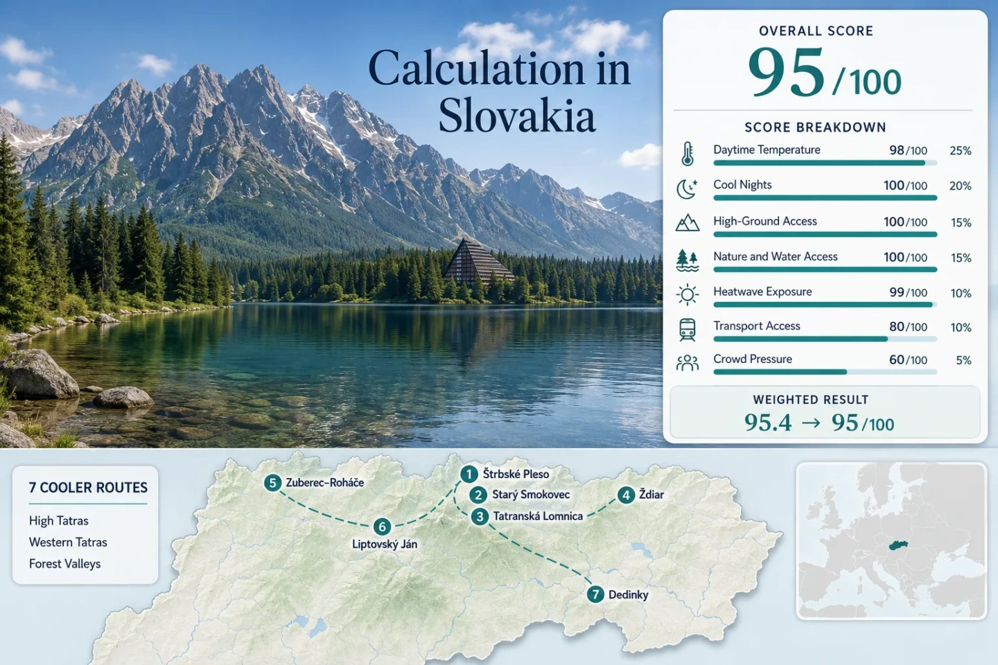
The markers follow the same seven bases used in the score and route comparison. Together they show the compact rail spine beneath the High Tatras and the wider west-to-east spread toward Roháče, Jánska Valley and Slovak Paradise.
This marker map is built for planning orientation. Marker positions use approximate public settlement centres, not guaranteed legal parking, trailheads or exact viewpoints. Use each route card for Google Maps links and access notes before travelling.
Slovakia Mountain Coolcation Suitability Score
This is a transparent editorial suitability index based on disclosed climate, landscape, access and pressure factors. It is not an official climate classification or a weather forecast. Route-centre climate values use rounded gridded proxies checked against Slovak Hydrometeorological Institute station context; the mixed elevation representation is reflected in the comparability grade.
Weighted total: 98×0.25 + 100×0.20 + 100×0.15 + 100×0.15 + 99×0.10 + 80×0.10 + 60×0.05 = 95.4 → 95/100
Method: Route count does not add bonus points. Route-level values are combined using the median before the fixed weights are applied. Proxy and station differences are disclosed rather than hidden inside the total.
High Tatras Bases, Roháče Valleys and Slovak Paradise Air
The seven bases differ less in whether mountain air is available than in how quickly it can be reached without a car, how exposed the route is to afternoon weather and how much peak-season capacity pressure sits between the accommodation base and the higher ground.
Štrbské Pleso and the Solisko Side
The highest accommodation base in the set sits near 1,346 metres, with the lake, forest paths and the cog railway all meeting at the settlement. The modelling values used in the score are about 19.0°C by day and 9.8°C at night for July–August, placing it comfortably inside the lowest-heat band.
The Solisko Express gives fast access toward higher, more exposed terrain, while the settlement itself remains practical on wet or low-cloud days.
Starý Smokovec, Hrebienok and the Waterfall Corridor
Starý Smokovec is the strongest interchange base: TEŽ trains meet the Hrebienok funicular, and the forested Studený potok corridor begins immediately above the settlement. The base is near 1,010 metres; the score uses a July–August proxy around 21.5°C maximum and 10.7°C minimum.
Car-free flexibility is the defining advantage. A stormy morning can be kept low in the forest, while a stable window supports Hrebienok and onward routes toward mountain huts.
Tatranská Lomnica to Skalnaté Pleso
The settlement base near 850 metres is warmer than Štrbské Pleso, but its vertical access is exceptional: the official gondola system reaches Skalnaté Pleso at 1,751 metres, with onward lift options toward Lomnické sedlo and the limited-capacity aerial tramway to Lomnický štít.
That makes Tatranská Lomnica a strong heat-burst backup, but only when wind, cloud and operating status permit. Advance booking matters more here than at the forest-valley bases.
Ždiar beneath the Belianske Tatras
Ždiar sits near 896 metres on the northern side of the range, away from the TEŽ rail spine. Regional buses connect it with the Poprad–Tatras corridor, while the village gives direct access to forest, mountain streams and the Belianske Tatras landscape.
The July–August night proxy is about 9.9°C, and 30°C days remain uncommon in the modelled window. The trade-off is more timetable dependence than in Starý Smokovec and less lake access at the accommodation base.
Zuberec and Roháčska Valley
Zuberec’s village base near 760 metres is lower than the High Tatras settlements, yet the Western Tatras rise quickly above the Roháčska Valley. Forest cover, the Roháče tarn circuit and trailheads around the 1,000-metre band create a different cooling pattern: less rail convenience, more long-valley immersion.
Modelled July–August values: About 20.5°C daytime, 9.4°C night-time and roughly 0.6% of days reaching 30°C in the ten-summer proxy window.
Bus access reaches the village, but a car improves early trailhead starts and reduces dependence on limited local links.
Liptovský Ján and the 18-Kilometre Jánska Valley
The village and resort band sits around 650–700 metres, making this the warmest daytime base in the set at a modelled 23.0°C for July–August. The compensation is an approximately 18-kilometre forested valley, stream-cooled walking and direct access toward Low Tatras terrain such as Poludnica at 1,549 metres.
The night proxy is about 11.8°C. Buses from Liptovský Mikuláš make the base viable without a car, though deeper valley movement is easier with one.
Dedinky, Palcmanská Maša and Southern Slovak Paradise
Dedinky stands near 795 metres beside the Palcmanská Maša reservoir, adding immediate water access to the forests, limestone plateaus and gorges of Slovak Paradise. The score uses a 22.0°C daytime proxy, 10.8°C night-time proxy and approximately 1.4% 30°C-day exposure.
Rail access is a genuine advantage, but service frequency can constrain day-trip timing. The national park also requires route-specific checks: high water, damaged infrastructure and seasonal ferrata rules can alter the practical plan.
How the Tatra Electric Railway Changes the Heat-Escape Decision
Štrbské Pleso for the Highest Car-Light Base
The cog railway from Štrba and the TEŽ line from Poprad place a 1,346-metre settlement inside the public-transport network. The accommodation base is already high, so a warm or cloudy day does not require a lift ticket to obtain cooler air.
Starý Smokovec for Flexible Weather Windows
Starý Smokovec is the network hinge. A short stable period can be used for Hrebienok, while rain or low cloud still leaves forest walking and frequent rail movement toward the other Tatras bases.
Tatranská Lomnica for Fast Vertical Gain
The lower base is warmer, but the gondola system moves directly to 1,751 metres. This route is strongest when the forecast is stable and tickets are secured; wind closures or summit capacity can remove the main advantage.
Which Slovak Mountain Base Fits the Summer Plan?
The comparison keeps all seven scored routes together. “Lowest-heat window” refers to the period most likely to combine mild daytime conditions with practical trail or lift access, not to a guarantee of cool weather.
| Route | Base elevation | Lowest-heat window | Car-light strength | Vertical access | Main trade-off |
|---|---|---|---|---|---|
| Štrbské Pleso | About 1,346 m | Late June to late August | Very strong | Solisko lift and high trails | Weekend lift and parking pressure |
| Starý Smokovec | About 1,010 m | June and September for lower pressure | Very strong | Hrebienok funicular | Busy waterfall corridor |
| Tatranská Lomnica | About 850 m | Stable July–August lift days | Very strong | Skalnaté Pleso at 1,751 m | Wind and ticket capacity |
| Ždiar | About 896 m | Late June to early September | Good by bus | Belianske Tatras trail access | Less timetable flexibility |
| Zuberec–Roháče | About 760 m | June and early September for quieter trails | Moderate | Roháčska Valley trailheads | Car useful for early starts |
| Liptovský Ján | About 650–700 m | June and September for cooler valley afternoons | Good to village | Low Tatras hikes from the valley | Warmest base in the set |
| Dedinky | About 795 m | Late June and September for fewer gorge queues | Good but frequency-sensitive | Plateau and gorge network | Wet ladders and route closures |
Why Štrbské Pleso Leads the Clear-Mountain-Air Balance
Štrbské Pleso is the most balanced route in this set because the cool-air advantage begins at the accommodation base rather than after a drive or lift. The settlement combines a high overnight base, lake-edge walking, forest cover, direct cog-rail access and optional ascent toward Solisko.
A wet morning can stay near the lake and forest, a stable afternoon can move higher, and a car is not required to reach the base. Tatranská Lomnica offers greater vertical range, but its main advantage depends more heavily on cableway operations and advance capacity.
Clear Mornings, Convective Afternoons and Forest Backups
Use Stable Mornings for Exposed Ground
High Tatras and Roháče routes can shift quickly from clear air to cloud, showers or thunderstorms. Early starts protect the higher part of the day and reduce exposure on ridges, saddles and lift-dependent routes.
Keep a Forest-Valley Alternative
Starý Smokovec’s waterfall corridor, Jánska Valley and the lower forest around Dedinky provide meaningful low-level alternatives. They do not remove lightning or flood risk, but they reduce dependence on exposed summits.
Treat Gorge Water as an Access Variable
In Slovak Paradise, rainfall changes more than comfort. Water levels, slippery ladders, bridge limits and temporary closures can determine whether a planned gorge is practical.