Sweden in Summer: Lakes, Forests and Mild Nordic Routes
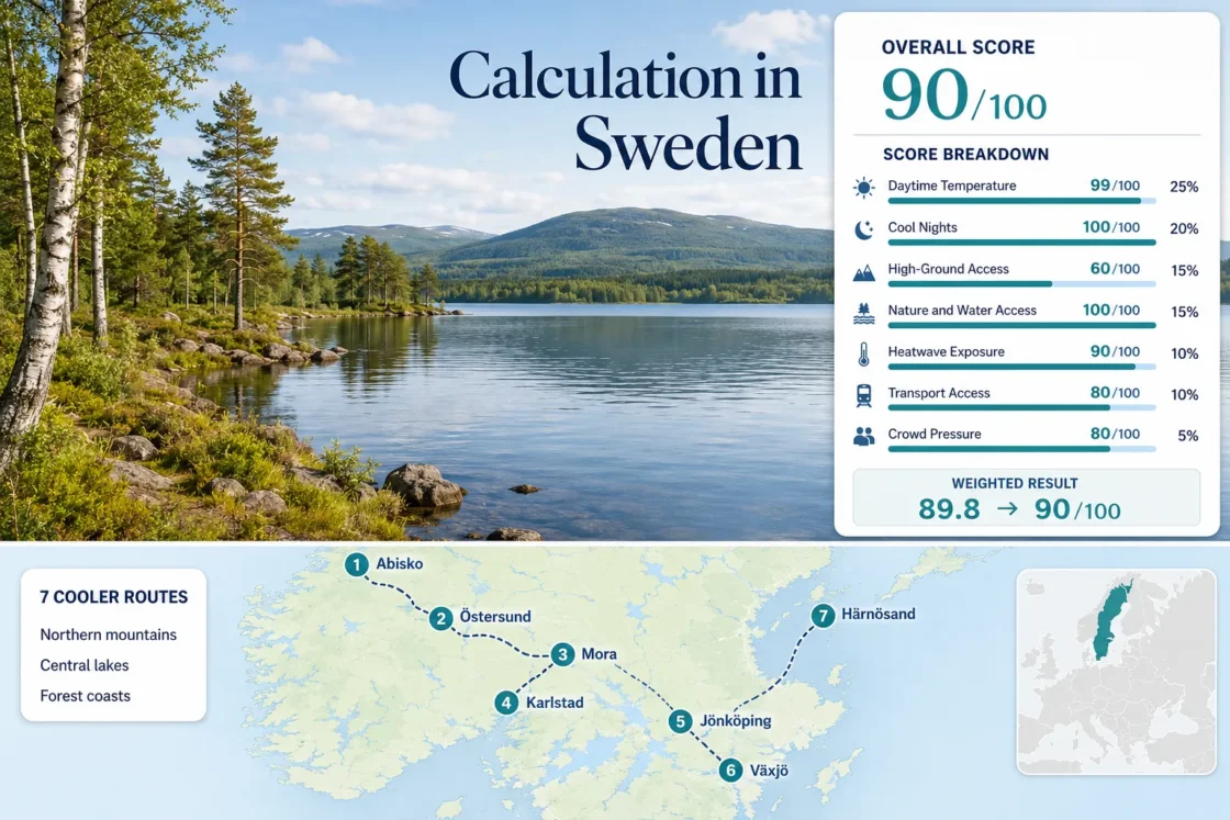
Sweden’s cooler-summer potential changes sharply between the Torneträsk mountains, the central lake districts, the forests of Småland and the Gulf of Bothnia coast. The seven-route set combines rail-served towns with direct access to large lakes, woodland, exposed shoreline and cooler nights. Abisko offers the lowest daytime heat exposure, while Östersund, Mora and Härnösand provide more balanced combinations of services, water access and car-light travel.
The score, marker map, route portfolio and main comparison use the same seven Swedish bases.
A subarctic rail stop beside Torneträsk, with the route set’s lowest July–August daytime median.
The seven-route median supports overnight cooling even when southern lake towns have warm afternoons.
Every base has rail access, although Åsnen, Skuleskogen and several forest trailheads need onward transport.
Vänern, Vättern and Siljan improve swimming access, but inland southern routes remain more exposed to brief hot spells.
Torneträsk, Central Lakes and Forest-Coast Route Geography
The markers follow a north-to-south range from Abisko beside Torneträsk to the forest-and-lake systems around Växjö. Numbering matches the destination cards and the route comparison.
Markers show selected cooler-route planning centres, not guaranteed legal parking areas, trailheads or exact viewpoints. Use the Google Maps link and access notes in each route card before travelling.
Sweden Lake and Forest Cooler Escape Suitability Score
This transparent editorial suitability index uses disclosed climate, landscape, access and peak-pressure factors. It is not an official climate classification, a comfort guarantee or a weather forecast.
Weighted total: 99×0.25 + 100×0.20 + 60×0.15 + 100×0.15 + 90×0.10 + 80×0.10 + 80×0.05 = 89.8 → 90/100
Method: Route count provides no bonus. Each route carries equal weight, route-level values are combined using the median, and the seven fixed factor weights are then applied.
Northern Lake Air, Central Forests and Gulf-Coast Bases
The northern routes reduce daytime heat most consistently. Central and southern bases exchange some of that thermal advantage for warmer swimming water, easier city services and shorter journeys from Sweden’s main population centres.
Abisko and Torneträsk
July–August route values: Approximately 16.2°C average daytime maximum, 7.6°C average minimum and a route base near 385 metres. The low night value is the clearest heat-relief signal in the portfolio.
Torneträsk, birch woodland and exposed mountain terrain create a very different summer rhythm from southern Swedish lake towns. Early July can retain near-continuous daylight, while August brings darker nights and faster evening cooling.
Östersund and Storsjön
Östersund combines a roughly 312-metre urban base with Storsjön shoreline access, direct rail services and a July–August temperature profile near 18.3°C by day and 10.2°C at night.
The city works as a car-light lake base, but major mountain terrain lies farther west. Local islands, shoreline paths and forest sectors are easier to reach than the highest Jämtland landscapes.
Mora and Siljan
Lake Siljan adds a strong swimming and paddling dimension to a route that still preserves substantial night cooling. The assessed July–August values are approximately 21.2°C for daily maximum and 10.3°C for daily minimum.
Mora has direct rail access, a base elevation near 160 metres and nearby forest roads leading toward higher Dalarna terrain. Its estimated 30°C+ threshold frequency is around 2.4% for the target window.
Karlstad and Northern Vänern
At roughly 46 metres above sea level, Karlstad has little altitude protection. Its cooling value comes from Vänern, broad shoreline exposure and access to the forests of Värmland.
Assessed climate range: Approximately 22.1°C average daytime maximum, 13.0°C average minimum and a 30°C+ threshold frequency near 4.0%. This is the warmest route in the seven-route daytime set.
Urban accommodation capacity lowers booking risk, but the quieter forest-and-lake sectors north and west of the city are easier with a car.
Jönköping and Southern Vättern
Vättern’s large, deep water body can keep shoreline air cooler than nearby inland districts, particularly when wind reaches Jönköping from across the lake.
The route’s assessed July–August values are approximately 21.6°C by day and 12.7°C at night. The Jönköping reference station sits about 87 metres above the immediate lake shore, so waterfront nights may occasionally remain milder than the station value implies.
The estimated 30°C+ threshold frequency is around 3.1%, and wind direction matters more here than a simple monthly average suggests.
Växjö and the Åsnen Lake District
Forest density is the main comfort asset. Växjö’s assessed route values are approximately 21.4°C for the daytime maximum and 12.1°C for the night minimum, with the urban base near 166 metres.
Åsnen National Park and the surrounding lake mosaic provide shaded cycling and paddling possibilities, but many access points are spread beyond the simplest urban bus network.
Härnösand and the High Coast
Härnösand adds Gulf of Bothnia air to a forested coast with unusually steep local relief. The assessed temperature profile is approximately 19.5°C by day and 11.7°C at night.
Direct rail reaches the urban base, while Skuleskogen, Skuleberget and dispersed coastal trailheads require onward buses, seasonal services or a car. The estimated 30°C+ frequency is around 1.1% for July–August.
Torneträsk Cold Water, Vättern Wind and Vänern Heat Bursts
Sweden’s large waters do not produce one uniform cooling effect. Latitude, depth, exposure and surrounding topography determine whether a route gains consistently cooler air or only temporary shoreline relief.
Torneträsk and Subarctic Air
Torneträsk sits within a mountain corridor far north of the Arctic Circle. Abisko’s 16.2°C daytime route value and 7.6°C night value reflect both latitude and elevation; the lake strengthens an already cool regional pattern rather than creating it alone.
Vättern’s Wind-Dependent Relief
Jönköping gains its clearest cooling when air crosses Vättern before reaching the southern shore. Offshore or inland flow can remove that advantage, leaving the city closer to the warmer Småland temperature pattern.
Vänern During Inland Warm Spells
Karlstad remains highly exposed to warm continental air despite its position beside Vänern. The lake supports shoreline breezes and water access, but its route has the portfolio’s highest daytime value and 30°C+ frequency.
Seven Routes Compared by Heat, Access and Main Trade-Off
Daytime temperature alone favours Abisko, but travel time, swimming conditions, city services and the final connection to forest or park terrain change the practical choice.
| Route | July–August Day | July–August Night | Primary Cooling System | Car-Light Reach | Main Trade-Off |
|---|---|---|---|---|---|
| Abisko and Torneträsk | 16.2°C | 7.6°C | Subarctic latitude, mountain air and a large cold lake | Very strong | Long journey, cold water and concentrated accommodation |
| Östersund and Storsjön | 18.3°C | 10.2°C | Lake exposure, elevation and northern inland nights | Very strong | Highest mountain terrain lies farther west |
| Mora and Siljan | 21.2°C | 10.3°C | Lake system, forest and strong overnight cooling | Strong | Warm inland afternoons and dispersed shore access |
| Karlstad and Vänern | 22.1°C | 13.0°C | Large-lake breeze and Värmland forest | Strong | Highest heat-burst exposure in the route set |
| Jönköping and Vättern | 21.6°C | 12.7°C | Deep-lake air and wooded shoreline relief | Strong | Cooling depends heavily on wind direction |
| Växjö and Åsnen | 21.4°C | 12.1°C | Dense forest shade and interconnected lakes | Moderate | Last-mile access and insects near still water |
| Härnösand and the High Coast | 19.5°C | 11.7°C | Gulf of Bothnia air, forest and coastal relief | Strong | Major park sectors require onward transport |
Night Trains, Lake-City Stations and the Last Forest Connection
Rail access makes every route base reachable without a private car, but only Abisko, Östersund and central urban shorelines place the cooling landscape directly beside the arrival point.
Routes Where the Landscape Starts at Arrival
Abisko’s railway stops sit beside Torneträsk and the national park corridor. Östersund station is within the Storsjön urban zone, while Mora, Karlstad and Jönköping provide walkable or bus-linked lake access from their centres.
The easiest rail arrival is not always the coolest route. Karlstad is simpler to reach from southern Sweden than Abisko, but its daytime heat exposure is substantially higher.
Routes With a Last-Mile Constraint
Åsnen’s park entrances, quieter Vänern forest sectors and the main High Coast trailheads are distributed beyond their rail cities. A regional bus may cover part of the distance, but service frequency, bicycle carriage and return timing must be checked for the travel date.
Do not treat “rail-served” as “fully car-free.” The transport score includes the complete route rather than the station alone.
Lowest Heat, Swimming Water and Darker Nights Occur at Different Times
The most useful Swedish summer window depends on whether the priority is low air temperature, warmer lake water, long hiking light or lower booking pressure.
Late June to Early July
Strong for: Long daylight, cooler air and early hiking access.
Abisko retains extremely long daylight, central forests are green and major lake water can still be cold. Some mountain paths may remain wet or snow-affected after late melt periods.
Mid-July to Mid-August
Strong for: Swimming, paddling and the widest operating season.
This is also the main school-holiday and booking-pressure window. Inland heat bursts become more relevant around Vänern, Vättern, Siljan and Småland.
Late August to Early September
Strong for: Cooler nights, darker sleep conditions and reduced family-holiday pressure.
Water remains usable in some southern lakes, but evenings cool quickly, daylight shortens in the north and seasonal transport or visitor services may become less frequent.
Midnight Light, Forest Insects and Fire-Risk Checks
Abisko’s early-summer light can disrupt sleep even when nights are thermally comfortable; blackout curtains or an eye mask are practical. Småland and Dalarna forest routes can have substantial mosquito activity near still water, especially after wet periods.
Dry summers can bring local fire restrictions, while warm lake periods may produce bathing-water or algal-bloom advisories. Check the current SMHI forecast, fire-danger information, park notices and regional transport timetable shortly before departure. Lake access, trail conditions and bus frequency can change without altering the historical climate profile.