Eswatini Highland Escapes: Mountain Roads, Forest Reserves and Cool Valley Mornings
Eswatini’s western highveld rises quickly from the warmer lowlands, placing mountain grassland, granite ridges, mistbelt forest and elevated settlements within a compact road network. January and February remain warm and wet, but early starts around Mbabane, Malolotja, Ngwenya and Bulembu can bring cooler mornings, lower night temperatures and more shade than the Nkomati Valley or eastern plains.
The route set follows the western highveld from Mbabane to Bulembu, then descends toward Phophonyane and Maguga.
High grassland, river gorges, wetlands and mistbelt forest create the most varied cooling pattern in one protected area.
The mountain rises above Bulembu near Eswatini’s north-western border and strengthens the area’s high-ground character.
Its large elevation range supports open grassland, forest pockets, streams, waterfalls and long walking routes.
The greenest highland period also brings wet trails, clouded ridges and fast changes in road visibility.
Reservoir air can improve dawn and evening comfort, but the lower Nkomati setting is warmer than the western ridge routes.
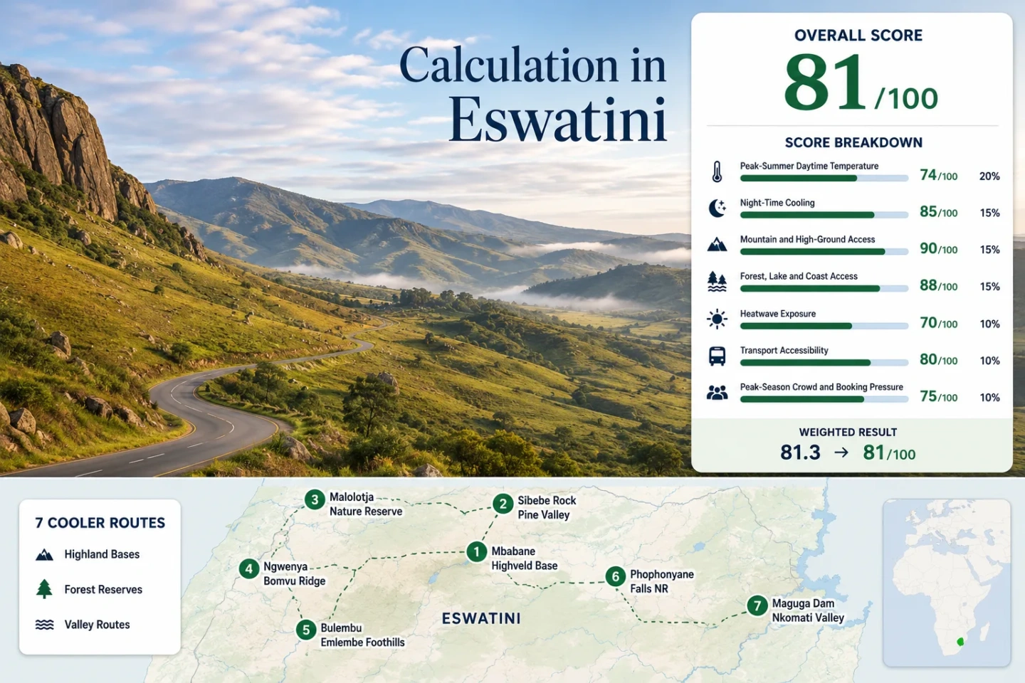
Western Highveld, Forest Reserve and Nkomati Route Markers
The markers connect Eswatini’s principal highland bases, protected landscapes and mountain-road stops. The sequence shows how quickly a route can move from Mbabane’s elevated urban services to exposed granite, mistbelt forest, remote border mountains and the warmer Maguga reservoir corridor.
Markers show selected route regions and approximate public planning centers, not guaranteed legal parking areas, trailheads or exact viewpoints. Use the Google Maps link and access notes in each route card before traveling.
Eswatini Highland Cooler Escape Suitability Score
This transparent editorial suitability index applies the same seven climate, landscape, access and capacity factors used across Cooler Escapes. It is not an official climate classification or a weather forecast. The score represents the seven routes shown on the map rather than Eswatini as a whole.
Method: Representative published climatology aggregation using January–February mean daily maximum temperatures.
Raw: Seven-route median of 26.0°C, normalized through the fixed daytime-temperature scale.
Route values: Mbabane 25.9°C; Sibebe 25.9°C; Malolotja 25.8°C; Ngwenya 25.8°C; Bulembu 25.9°C; Phophonyane 26.0°C; Maguga 29.0°C.
Source mapping: Mbabane represents the central highveld routes; Pigg’s Peak and Bulembu climatologies represent the north-western mountain routes; Ngonini is used as a lower-valley proxy for Maguga. These are regional planning proxies rather than direct measurements at every attraction.
Period: Published climate summaries interpreted against the Eswatini Meteorological Service 1991–2020 normal framework.
Sources: Eswatini Meteorological Service State of the Climate; Mbabane published climatology; Pigg’s Peak published climatology.
Method: Representative published climatology aggregation using January–February mean daily minimum temperatures.
Raw: Seven-route median of 16.5°C. The fixed scale awards its highest range to average summer minima between 10°C and 16°C, with linear reduction above 16°C.
Route values: Mbabane 16.5°C; Sibebe 16.5°C; Malolotja 16.4°C; Ngwenya 16.4°C; Bulembu 16.5°C; Phophonyane 16.6°C; Maguga 19.0°C.
Source mapping: The same representative-station framework used for daytime temperature is retained so the route median is internally consistent. Maguga’s lower elevation produces the warmest overnight proxy.
Period: Published climate summaries with official long-term minimum-temperature context.
Sources: Eswatini Meteorological Service long-term minimum temperatures; Mbabane climate summary; Pigg’s Peak climate summary.
Method: Fixed categorical high-ground rubric based on accommodation elevation or practical access to land above 1,000–1,500 metres.
Raw: Median categorical route score of 100/100.
Route scores: Mbabane 80 — elevated highveld base; Sibebe 100 — direct access to a 1,488-metre granite massif; Malolotja 100 — extensive mountain reserve; Ngwenya 100 — high western ridge; Bulembu 100 — 1,215-metre settlement with Emlembe nearby; Phophonyane 60 — forested hillside below the highest ridge; Maguga 30 — lower reservoir valley.
Route rationale: Five of the seven routes begin on or immediately beside highland terrain. The lower Phophonyane and Maguga stops broaden the road circuit but do not raise the median.
Period: Access and landscape status reviewed July 21, 2026.
Sources: Eswatini Tourism — Sibebe Rock; Eswatini National Trust Commission — Malolotja; Eswatini Tourism — Bulembu and Emlembe.
Method: Fixed physical-access rubric measuring substantial forest, lake, river or coast access within 30–60 minutes of each route.
Raw: Median categorical route score of 75/100.
Route scores: Mbabane 75 — nearby forested valleys; Sibebe 75 — Pine Valley and river access; Malolotja 100 — forest, wetlands and river systems; Ngwenya 75 — mountain vegetation and reserve terrain; Bulembu 75 — surrounding plantation and mountain forest; Phophonyane 100 — natural forest, river and falls; Maguga 75 — immediate access to a large reservoir.
Route rationale: Eswatini has no coast, so the factor is carried by mistbelt forest, river gorges, waterfalls and reservoir access rather than maritime air.
Period: Landscape and visitor-access status reviewed July 21, 2026.
Sources: Eswatini National Trust Commission — Malolotja habitats; Eswatini Tourism — Phophonyane Nature Reserve; Eswatini Tourism — Maguga Dam.
Method: Data-limited published-event proxy mapped to the fixed 30°C-or-higher exposure scale. This is not an exact ten-summer daily threshold count.
Raw: Median route exposure band of 5%, producing 75/100 under the fixed normalization thresholds.
Route proxy bands: Mbabane 5%; Sibebe 5%; Malolotja 5%; Ngwenya 5%; Bulembu 5%; Phophonyane 5%; Maguga 12%.
Source mapping: Highveld routes share the lower-exposure band because of elevation and lower published summer means. Maguga receives a higher band because the Nkomati Valley is warmer. Eswatini Meteorological Service documentation confirms that extreme heat can still reach the highveld, including a 36.2°C Mbabane event in December 2024.
Period: 1991–2020 climate-normal context with documented 2024 heat-event evidence. Exact route-level valid-day coverage was not available, which limits cross-route comparability.
Sources: Eswatini Meteorological Service State of the Climate 2024; Peer-reviewed analysis of Eswatini temperature trends.
Method: Fixed categorical transport rubric based on road simplicity, public-transport practicality and the need for private local transfers.
Raw: Median categorical route score of 60/100.
Route scores: Mbabane 100 — national transport and service hub; Sibebe 60 — straightforward road approach but local mobility is easier by car; Malolotja 60 — road access with a vehicle useful inside the wider reserve area; Ngwenya 80 — positioned on the western MR3 corridor; Bulembu 40 — remote approach with a rough-road warning; Phophonyane 60 — road-accessible but local transfers are useful; Maguga 60 — practical road loop with limited car-light flexibility.
Route rationale: Mbabane is the only route with strong urban transport flexibility. The northern circuit becomes progressively more vehicle-dependent, particularly around Bulembu, Phophonyane and Maguga.
Period: Road and destination-access descriptions reviewed July 21, 2026. No unified route-level timetable dataset was available.
Sources: Eswatini Tourism — North-West route overview; Eswatini Tourism — Bulembu access note; Eswatini Tourism — Maguga road loop.
Method: Fixed categorical pressure rubric using destination scale, accommodation concentration and protected-area capacity as practical indicators.
Raw: Median categorical route score of 80/100.
Route scores: Mbabane 80 — broadest lodging supply; Sibebe 80 — mainly day-use pressure; Malolotja 60 — finite cabins and camps; Ngwenya 80 — limited attraction-scale congestion; Bulembu 80 — low density but small lodging base; Phophonyane 60 — concentrated private-lodge capacity; Maguga 60 — limited reservoir-side accommodation and activity capacity.
Route rationale: The main risk is not widespread crowding but a shortage of rooms, cabins or organised activities at isolated stops. Weekend and holiday demand can therefore matter even when roads and trails feel quiet.
Period: Current destination-capacity review completed July 21, 2026. Comparable three-year occupancy statistics were not available for every route.
Sources: Eswatini National Trust Commission — Malolotja facilities; Eswatini Tourism — Phophonyane accommodation; Eswatini Tourism — Maguga facilities.
Factor coverage: 7 of 7. Route count does not create a score bonus; every mapped route carries equal weight before the factor median is calculated.
Mountain Roads from Mbabane to the Nkomati Valley
The route portfolio follows a descending arc. Mbabane, Sibebe, Malolotja, Ngwenya and Bulembu emphasize elevation and cooler nights; Phophonyane adds dense forest shade; Maguga shifts the focus toward water access and dawn comfort in a warmer valley.
Mbabane Highveld Base
Mbabane provides the most practical highland base for travelers who need supermarkets, restaurants, fuel, urban accommodation and onward transport. Published January–February proxies place typical daytime highs near 26°C and nights around 16–17°C, offering meaningful overnight relief without guaranteeing cool afternoons.
Route metrics: Highveld city around the 1,200-metre elevation band; January–February proxy near 25.9°C by day and 16.5°C at night; immediate access to the MR3 corridor; the broadest service range in the route set.
Urban surfaces can still feel warm during sunny afternoons. The stronger use of Mbabane is as an early-morning launch point for Sibebe, Ngwenya and Malolotja rather than as a shaded nature retreat.
Sibebe Rock and Pine Valley
Sibebe rises north of Mbabane as a vast exposed granite formation, reaching roughly 1,488 metres. Its elevation supports cooler starts, but the open rock absorbs direct sunlight and offers less shade than Malolotja or Phophonyane.
Route metrics: About 10 kilometres from Mbabane; summit elevation around 1,488 metres; representative January–February climate near 25.9°C by day and 16.5°C at night; road approach through Pine Valley; limited shelter on exposed rock.
An early departure changes the route substantially. Morning cloud, valley air and lower solar exposure can make the approach comfortable, while a clear midday crossing can feel hotter than the air temperature suggests.
Malolotja Nature Reserve
Malolotja is the strongest all-round cooling landscape in the portfolio because it combines high grassland, wooded valleys, wetlands, streams and deep river gorges. The reserve covers about 18,000 hectares and contains roughly 200 kilometres of walking routes, creating far more choice than a single viewpoint stop.
Route metrics: Extensive mountain reserve; approximately 200 kilometres of trails; 17 backpacking camps identified by the reserve authority; highveld climate proxy around 25.8°C by day and 16.4°C at night; forest, wetland and river access within the protected area.
Open ridges can be windy and exposed, while descending paths become warmer, wetter and more humid. Route comfort therefore depends on elevation, cloud level and how far the walk drops into a gorge.
Ngwenya Mine and Bomvu Ridge
Ngwenya sits on Eswatini’s western high ground near the South African border, where the MR3 climbs through a cooler and frequently cloudier landscape. The old mine area and Bomvu Ridge are more exposed than the forest reserves, making wind, fog and visibility as important as temperature.
Route metrics: High western-ridge setting; direct approach from the MR3 corridor; representative January–February values near 25.8°C by day and 16.4°C at night; strong elevation access; minimal natural shade around disturbed mine terrain.
The route works well as a short highland stop between Mbabane and Malolotja. It is less suitable as an all-day heat refuge because exposed slopes can become bright and warm once cloud clears.
Bulembu and Emlembe Foothills
Bulembu occupies a high mountain basin near Eswatini’s northern border. The settlement lies around 1,215 metres, while Emlembe rises to approximately 1,862 metres nearby. Forested slopes and elevation support cool mornings, but access requires more planning than the Mbabane–Ngwenya corridor.
Route metrics: Settlement elevation around 1,215 metres; Emlembe summit approximately 1,862 metres; representative January–February climate near 25.9°C by day and 16.5°C at night; eucalyptus and mountain-forest surroundings; rough-road warning on the western approach from Pigg’s Peak.
The destination rewards overnight stays more than rushed day trips. Late arrival reduces the value of the cool morning period and leaves less margin for fog, rain or slow road conditions.
Phophonyane Falls Nature Reserve
Phophonyane lies on a forested hillside north of Pigg’s Peak, where the river and waterfalls create a shaded alternative to exposed highveld ridges. The air may feel cooler under the canopy, although summer humidity can remain high after rain.
Route metrics: Roughly 10 kilometres north of Pigg’s Peak; forest, river and waterfall access in one compact area; representative January–February climate near 26.0°C by day and 16.6°C at night; private accommodation concentration; wet-trail exposure during the rainy season.
This is the route for shade rather than maximum altitude. Forest cover reduces direct solar load, while wet ground, insects and humidity can make longer walks feel heavier than ridge routes at the same air temperature.
Maguga Dam and Nkomati Valley
Maguga broadens the circuit from mountain air to water-based comfort. The reservoir can produce calmer, fresher mornings and evening breezes, but the Nkomati Valley is lower and warmer than Mbabane, Malolotja or Bulembu.
Route metrics: Eswatini’s largest reservoir; dam wall approximately 115 metres high; lower-valley January–February proxy near 29.0°C by day and 19.0°C at night; road-loop access from the MR1; limited shaded public space compared with forest reserves.
Maguga is not the route to choose for the lowest midday temperature. Its value lies in water views, early departures, evening conditions and a logical connection between Pigg’s Peak, Phophonyane and the central road network.
Seven Routes Compared by Cooling Lever and Access
Air temperature alone does not determine comfort. Shade, elevation, surface exposure, overnight cooling and road dependence separate the seven routes more clearly than a single country-wide forecast.
| Route | Primary Cooling Lever | January–February Character | Access Pattern | Main Trade-Off | Useful Timing |
|---|---|---|---|---|---|
| Mbabane Highveld Base | Elevation and night cooling | Warm afternoons, mild nights and frequent summer rain | Strongest service and transport base | Urban surfaces reduce midday cooling | Overnight base with early departures |
| Sibebe Rock and Pine Valley | High ground and valley morning air | Cool starts but strong solar exposure on granite | Short road trip from Mbabane; car useful | Wet rock, little shade and storm exposure | Morning before cloud builds or rock heats |
| Malolotja Nature Reserve | Elevation, mistbelt forest and river gorges | Green, wet and changeable across altitude bands | Road-accessible reserve; vehicle useful | Fog, wet trails and long internal distances | Full day with a flexible walking plan |
| Ngwenya Mine and Bomvu Ridge | Western ridge elevation and wind | Cloudy or breezy starts with exposed afternoons | Convenient MR3 corridor stop | Limited shade on disturbed terrain | Short stop paired with Mbabane or Malolotja |
| Bulembu and Emlembe Foothills | High settlement and nearby summit terrain | Cool mornings, wet mountain weather and forest air | Remote road approach; advance planning useful | Road condition and limited local capacity | Overnight stay rather than a rushed detour |
| Phophonyane Falls Nature Reserve | Forest canopy, river and waterfall shade | Shaded but humid during the rainy season | Road access with local transfer flexibility | Wet trails, insects and humidity | Morning forest walk or overnight retreat |
| Maguga Dam and Nkomati Valley | Reservoir air and open-water exposure | Warmest route, with better dawn and evening comfort | Road-loop destination; car strongly useful | Higher midday heat and limited shade | Sunrise, late afternoon or an onward road stop |
MR3, MR1 and the Bulembu Spur Change the Route Rhythm
Eswatini’s compact size can make the northern circuit look effortless on a map, but road character changes quickly between the western highway, reserve approaches, border mountains and the lower reservoir valley.
MR3 as the Highveld Spine
Mbabane and Ngwenya sit on the most straightforward section of the route. This corridor supports short highland stops, flexible returns to the capital and easier changes when thunderstorms obscure exposed viewpoints.
The Malolotja Branch Requires Time
Reaching the reserve entrance is only the beginning of a Malolotja day. Trailheads, viewpoints and gorges are spread across a large protected area, so a late arrival sharply reduces route choice.
Bulembu Is Not a Casual Road Add-On
The mountain approach is slower and more condition-sensitive than the main highveld corridor. Heavy rain, fog or a late departure can turn an attractive loop into a tiring transfer.
Maguga Completes a Warmer Return Loop
The MR1 connection allows the northern route to descend toward Maguga instead of retracing every highland road. The trade-off is a clear rise in daytime heat as the circuit enters the Nkomati Valley.
Mistbelt Forest, Granite and Reservoir Air Produce Different Comfort
Malolotja’s Mistbelt and Gorge Contrast
Cloud and wind can keep the upper grassland cool, while lower gorges become more humid and sheltered. A route that descends several hundred metres may feel substantially warmer on the return climb even within the same reserve.
Sibebe’s Granite Stores Solar Heat
Elevation lowers the surrounding air temperature, but bare granite receives direct sun and provides little evaporative cooling. Cloudy mornings can feel fresh; clear midday conditions can feel harsher than nearby shaded valleys.
Phophonyane Trades Heat for Humidity
Canopy shade reduces radiant heat and the river cools the immediate walking environment. After summer rain, however, high humidity and wet ground may slow walking and reduce the cooling benefit.
Bulembu Benefits from Mountain Nights
Its elevated basin and surrounding slopes support lower night temperatures than the Nkomati Valley. An overnight stay captures the most reliable cool period: late evening through the first hours after sunrise.
Ngwenya’s Ridge Comfort Depends on Wind
Wind can make the western ridge feel noticeably fresher, but the same exposure becomes uncomfortable during heavy rain or low cloud. Sheltered clothing remains useful even when the forecast temperature looks mild.
Maguga’s Water Advantage Is Time-Sensitive
The reservoir moderates the immediate shoreline most effectively around dawn and evening. It cannot fully offset the lower valley’s warmer daytime air, especially at exposed viewpoints with little shade.
January and February Bring Green Slopes and Storm Interruptions
Eswatini’s rainy season generally runs from October into March. The highveld is at its greenest in January and February, but the same rainfall that feeds waterfalls and mistbelt vegetation can interrupt exposed walks and remote-road plans.
Early Morning: The Clearest Cooling Window
Night-time minima around the mid-teens make sunrise departures the most dependable comfort strategy. Sibebe, Ngwenya and Maguga benefit especially from starting before exposed surfaces heat.
Midday: Move Toward Shade or Altitude
Phophonyane’s canopy and Malolotja’s higher ground offer stronger midday options than Maguga’s open reservoir edge. Granite, mine slopes and unshaded roads can feel much warmer under direct sun.
Afternoon: Keep a Storm Buffer
Thunderstorms, low cloud and heavy showers can reduce visibility and make wet roads or trails slower. Remote routes should retain enough daylight for an unhurried return.
Overnight: Stay Where the Morning Matters
Bulembu, Malolotja and Phophonyane become more rewarding when the itinerary includes a night nearby. A day trip that arrives after noon misses much of their temperature advantage.
Weather, Trail and Road Checks Before a Highland Circuit
Check current warnings: Eswatini Meteorological Service advisories should take priority over climate averages when thunderstorms, heavy rain, strong wind or extreme heat are possible.
Confirm reserve access: Trail availability, gate times, accommodation and organised activities can change after heavy rain or maintenance work.
Verify the Bulembu approach: Road condition and the intended entry direction matter more here than on the Mbabane–Ngwenya corridor.
Carry a warm and waterproof layer: Highveld mornings, wind and cloud can feel cool even when the afternoon forecast reaches the mid-twenties.