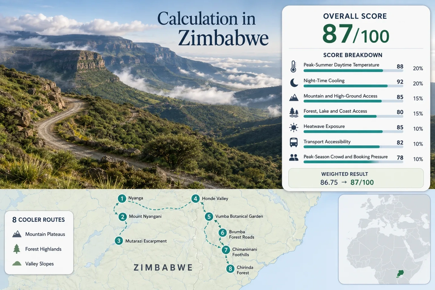
Zimbabwe Cooler Landscapes: Eastern Highlands, Forest Roads and Mountain Retreats
Zimbabwe’s Eastern Highlands replace the hotter lowland pattern with exposed plateaus, mist-prone forest slopes, mountain foothills and deeply cut valleys. The strongest cool-air routes run through Nyanga, Bvumba and Chimanimani, but their conditions are not interchangeable: high Nyanga delivers colder nights, Bvumba adds shaded forest roads and damp air, while Chimanimani combines mild daytime temperatures with more demanding mountain access.
The portfolio extends from the Nyanga plateau to Chirinda Forest without adding a score bonus for route count.
Zimbabwe’s dry-season winter produces the clearest contrast between mild afternoons, cold mornings and rapidly cooling mountain evenings.
The summit massif rises to 2,592 metres, while practical overnight bases remain lower and less exposed than the upper mountain.
Dense canopy and eastern-slope moisture reduce direct solar exposure but introduce fog, wet surfaces and shorter sightlines.
Warmer valley-floor conditions can sit below distinctly cooler upper slopes, making accommodation elevation more important than the regional name.
Sunny afternoons do not remove frost-pocket risk, damp forest-road conditions or the need for warm accommodation after sunset.
Nyanga, Bvumba and Chimanimani Route Geography
The selected routes form a north-to-south highland chain along Zimbabwe’s eastern border. Markers indicate practical planning centres rather than exact viewpoints, trailheads, legal parking positions or accommodation entrances.
This marker map is built for planning orientation. Marker positions use approximate public location centres where exact viewpoints, trailheads, legal parking areas or pull-offs are not specified. Use each route card for Google Maps links and access notes before travelling.
Zimbabwe Eastern Highlands Cooler Escape Suitability Score
This transparent editorial suitability index uses disclosed climate, landscape, access and pressure factors. It is not an official climate classification, road assessment or weather forecast. Temperature inputs combine published climatology pages with route-centre and elevation proxies, so the comparability rating remains C.
Weighted total: 96×0.25 + 100×0.20 + 100×0.15 + 100×0.15 + 100×0.10 + 40×0.10 + 70×0.05 = 91.5 → 92/100
Method: Route count does not add bonus points. Each route carries equal weight, route-level values are combined using the median and the seven fixed factor weights are then applied. Humidity, fog and rainfall affect planning notes but are not hidden score factors.
High Plateaus, Forest Roads and Southern Mountain Bases
Each route produces a different form of cool-weather access. Temperatures shown in the cards are July–August planning proxies consistent with the score evidence, not live forecasts or guaranteed conditions.
Nyanga and Troutbeck High Plateau
Open highland air and rapid evening cooling define the accommodation belt between Nyanga and Troutbeck. Much of the practical retreat zone sits roughly between 1,650 and 2,000 metres, with a July–August daytime proxy of 23.5°C and an overnight proxy of 11.5°C.
Sunny winter afternoons may feel mild in sheltered areas, but exposed gardens, dams and ridge-facing properties cool quickly after sunset. Accommodation heating, wind exposure and morning vehicle conditions matter more than daytime photographs suggest.
Mount Nyangani
Mount Nyangani reaches 2,592 metres, but the mountain score does not treat summit conditions as an overnight climate. The route-centre proxy is 21.2°C by day and 8.7°C at night during July–August, with stronger wind exposure above the park’s lower road and accommodation areas.
The route receives full high-ground access credit because the mountain rises directly from an already elevated park landscape. Forest-and-water access is lower than the Pungwe and Mutarazi route because the upper mountain is dominated by exposed highland terrain.
Mutarazi and Pungwe Escarpment
A July–August daytime proxy of 22.4°C combines with an overnight proxy near 10.2°C across the elevated escarpment. The route gains a second cooling influence from river-cut terrain, waterfall corridors and alternating forest cover.
Open viewpoints and enclosed road sections behave differently. Exposed stops may be windy, while shaded approaches can remain damp and noticeably colder after drizzle or overnight condensation.
Honde Valley Upper Slopes
The useful cool-air route is not the whole Honde Valley. The valley averages roughly 900 metres in elevation, while surrounding slopes rise far higher. Upper-slope accommodation receives a 24.6°C daytime proxy and a 12.1°C night proxy, but lower tea-growing and river sections can feel distinctly warmer.
The route remains car-dependent because viewpoints, estates and upper-slope stays are dispersed. It nevertheless provides a useful option for travellers who want green landscapes and cooler nights without the strongest frost exposure of high Nyanga.
Vumba Botanical Garden
The garden lies about 32 kilometres from Mutare according to Zimbabwe’s official tourism information, creating one of the shorter transitions from a city base into higher, greener air. The route proxy is 22.0°C by day and 10.0°C overnight during July–August.
Tree cover limits direct sun, but the garden should not be treated as a complete substitute for a high ridge. Its strongest value is accessible forest shade, not extreme altitude or guaranteed all-day cold.
Bvumba Forest Roads
Bvumba’s enclosed roads, ridge properties and cloud-prone forest edges receive a 21.4°C daytime proxy and a 9.4°C overnight proxy. The main cooling experience comes from canopy, elevation and reduced direct solar load rather than a single summit.
The same canopy that protects road surfaces from prolonged sun can delay drying. Morning mist, leaf litter and moisture on bends may make a short road transfer slower than its distance suggests.
Chimanimani Village and Mountain Foothills
A representative July–August profile of about 19.0°C by day and 8.4°C overnight makes Chimanimani the coolest settlement-and-foothill proxy in the route set. Village conditions remain less exposed than the higher quartzite ridges reached on foot.
ZimParks advises visitors to carry warm, windproof and waterproof clothing for mountain activity. That advice reflects a route where an apparently mild village morning can develop into colder wind, cloud or drizzle at elevation.
Chirinda Forest and Mount Selinda
Chirinda extends the cooler-landscape portfolio into southern Manicaland. The Forestry Commission describes it as an approximately 960-hectare remnant rainforest, while the surrounding Mount Selinda highlands create a shaded route with a 21.7°C daytime proxy and a milder 13.4°C night proxy.
The southern location increases road time and reduces transport convenience. Forest humidity can also make 13°C feel colder indoors when rooms receive limited sun or wet equipment cannot dry easily.
Eight Eastern Highlands Routes Compared
The coldest temperature is not the only useful measure. Forest moisture, walking demand, road dependence and the difference between valley floors and accommodation bases can change the practical result.
| Route | July–August proxy | Main cooling system | Local access pattern | Primary trade-off |
|---|---|---|---|---|
| Nyanga and Troutbeck High Plateau | 23.5°C day / 11.5°C night | Open plateau, altitude and rapid evening cooling | Road-accessible accommodation belt; private mobility useful | Wind and frost pockets |
| Mount Nyangani | 21.2°C day / 8.7°C night | High mountain exposure | Park road followed by mountain walking | Weather exposure and route difficulty |
| Mutarazi and Pungwe Escarpment | 22.4°C day / 10.2°C night | Escarpment, rivers and waterfall corridors | Condition-sensitive secondary park roads | Fog and variable final approaches |
| Honde Valley Upper Slopes | 24.6°C day / 12.1°C night | Elevation transition above a warmer valley | Dispersed estates and slope accommodation | Property elevation can change the result |
| Vumba Botanical Garden | 22.0°C day / 10.0°C night | Forest shade and highland air | Short road transfer from Mutare | Garden altitude is lower than exposed ridges |
| Bvumba Forest Roads | 21.4°C day / 9.4°C night | Canopy, mist and reduced solar load | Car-light only with arranged transfers; otherwise vehicle-oriented | Damp bends and reduced visibility |
| Chimanimani Village and Mountain Foothills | 19.0°C day / 8.4°C night | Mountain-base elevation and cold night air | Long regional approach plus route-specific walking | Higher physical and weather demands |
| Chirinda Forest and Mount Selinda | 21.7°C day / 13.4°C night | Rainforest canopy and southern highland elevation | Long road access with limited visitor transport | Humidity, fewer facilities and extended travel time |
Nyanga, Bvumba and Chimanimani Do Not Cool the Same Way
Nyanga’s Open Plateau Air
Nyanga’s strongest cooling comes from high accommodation bases, open terrain and rapid heat loss after sunset. Troutbeck and the park plateau can feel comfortable in direct afternoon sun, then become cold enough for heating soon after dark.
The exposed landscape also increases wind chill. A sheltered lodge garden and an open Mount Nyangani slope should never be treated as the same thermal environment.
Bvumba’s Cloud-Forest Effect
Bvumba reduces solar load through forest cover, eastern-slope cloud and frequent shade. The result is often damp coolness rather than dry plateau cold.
Forest cottages can remain cool throughout the day, but limited sunlight may also slow indoor warming and make wet clothing difficult to dry.
Chimanimani’s Mountain-Base Contrast
Chimanimani Village offers a high and comparatively mild base, while the surrounding ridges introduce stronger wind, lower temperatures and greater weather exposure.
The route works particularly well for active travellers, but the cold-air advantage comes with more walking, fewer easy fallback stops and a longer approach than Bvumba.
The Honde and Mutare Warm-Valley Trap
Eastern Highlands addresses can conceal large elevation differences. A regional label is less useful than the elevation of the sleeping base, the surrounding slope and the time needed to reach shaded or exposed high ground.
Honde Valley Floor Versus Upper Slopes
The Honde Valley floor lies near 900 metres in many areas, while adjacent ridges rise above 1,800 metres. Lower tea and river areas can warm noticeably during the afternoon even when an upper-slope retreat remains mild.
Booking check: Ask for the property elevation or a precise map position rather than relying on “Honde Valley” alone.
Mutare Versus the Bvumba Climb
Mutare provides services and the practical road gateway, but the city climate does not represent a ridge cottage or forest garden higher in Bvumba. Temperature, cloud and wind can change during the relatively short climb south of the city.
A Mutare overnight and a Bvumba overnight therefore serve different comfort goals even when they are part of the same itinerary.
Chimanimani Village Versus Upper Ridges
The village is a useful accommodation and supply base, not a substitute for upper-mountain observations. Cloud, wind and temperature can change rapidly once a route leaves the protected foothills.
Planning threshold: Village forecast conditions should be treated as the starting reference rather than the expected ridge maximum or minimum.
Forest-Road Cooling From Bvumba to Chirinda
Forest shade can improve daytime comfort without making a route easier. Bvumba and Chirinda trade direct solar exposure for moisture, darker road corridors and potentially slower driving.
What the Canopy Changes
Closed tree cover limits the time road surfaces and accommodation walls spend in direct sun. Shaded walking starts can remain cooler than open Nyanga viewpoints at the same hour.
Forest protection also reduces exposure to strong plateau wind, creating a calmer but more humid form of cool weather.
What the Canopy Complicates
Mist, wet leaf litter, shaded bends and limited sightlines can slow travel. A route that appears short by distance may require more daylight than an open paved plateau road.
Cooler does not mean easier: Check the last approach, recent rain and the property’s arrival instructions before entering unfamiliar forest roads near dusk.
Cold Mornings, Mild Afternoons and the July–August Trade-Off
May to June
Night cooling strengthens while the most severe high-plateau morning cold is not yet present every day. This period suits forest roads and mixed Nyanga itineraries where a slightly softer night profile is preferred.
July to August
The route set reaches its clearest cool-air pattern: dry-season sunshine, cold starts, short mountain evenings and low 30°C exposure. Nyanga can develop frost pockets, while Manicaland can still receive cold south-easterly cloud or drizzle.
September
Night temperatures begin to moderate and afternoon heat increases, especially in Honde Valley and lower approach roads. Chimanimani walking may become more comfortable for travellers who find July nights too cold.
The Zimbabwe Meteorological Services Department has documented winter frost risk, cold south-easterly airflow and region-specific temperature thresholds in the Eastern Highlands. Seasonal outlooks do not replace the final 72-hour forecast, park access confirmation or accommodation heating check.
Mountain Retreats Need More Than a Highland Address
Plateau Lodges
Check room heating, wind exposure, morning vehicle access and whether large windows receive useful winter sun.
Forest Cottages
Confirm ventilation, dry-storage space, backup power and how wet clothing or boots can be dried overnight.
Valley-Edge Retreats
Request the property elevation and slope position. A valley label may conceal a warm floor or a much cooler upper edge.
Hiking Bases
Prioritise early breakfast arrangements, secure equipment storage, guide access and a reliable plan for returning before dark.
Final Checks for Eastern Highlands Roads and Cold Nights
| 72-hour weather | Check frost, wind, low cloud, drizzle and the difference between the town forecast and higher terrain. |
|---|---|
| Road approach | Confirm the final road surface, recent rain, daylight arrival time and whether ordinary vehicles are currently suitable. |
| Park or forest access | Verify opening arrangements, entry procedures, trail advice and any temporary restriction with the responsible authority. |
| Accommodation heating | Ask whether heating is included, whether backup power is available and how rooms perform during cold or damp nights. |
| Route choice | Use Nyanga for exposed plateau cooling, Bvumba for shaded forest air, Chimanimani for active mountain terrain and Chirinda for a quieter southern forest profile. |