Lesotho Coolcation Routes: High Passes, Mountain Dams and Kingdom-in-the-Sky Air
Lesotho’s summer-cooling advantage comes from altitude rather than latitude. Every route in this portfolio sits within a country entirely above 1,000 metres, while several road crests, lodging bases and protected plateaus rise well beyond 2,000 metres. January and February can still bring warm sun, heavy showers and fast-changing visibility, but highland nights, exposed passes and elevated reservoir basins create a markedly different rhythm from the hotter lowlands surrounding the kingdom.
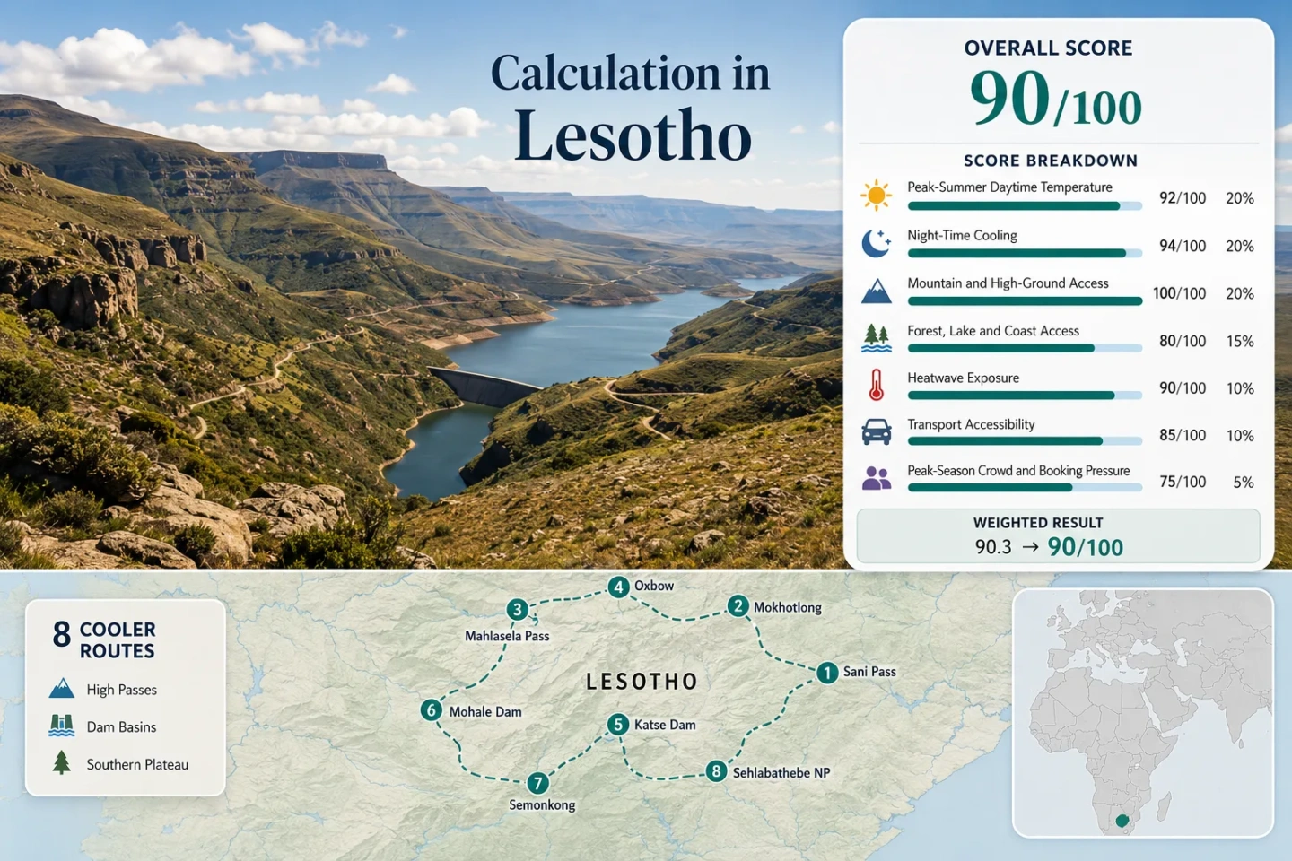
The same eight routes are used for the marker map, score calculation and decision matrix.
Lesotho is the only sovereign state whose entire territory lies above this elevation threshold.
Lesotho Meteorological Services recorded these 2022 mean maxima for January and February.
Katse and Mohale full-supply levels keep both dam routes firmly within highland air.
Most annual precipitation falls from October to April, with the wettest pattern around December to February.
Remote passes, dam loops and park approaches generally reward a capable vehicle and generous daylight margins.
Maloti Passes, Dam Basins and Southern Plateau Markers
The markers connect northern pass country, central reservoir roads and the southeastern plateau. They show planning centres rather than exact viewpoints, legal parking areas or trailheads.
Markers use approximate public location centres. Use the Google Maps link and access notes in each route card before travelling, and confirm border, park and road conditions locally.
Lesotho Highland Cool-Air Suitability Score
This transparent editorial suitability index applies one fixed seven-factor method to the eight displayed routes. It is not an official climate classification or a weather forecast. Route count does not add a bonus; each route carries equal weight before factor medians are calculated.
Method: January–February mean daily maximum temperature for direct or representative highland stations; eight route values were sorted and the median was normalised with the fixed daytime-temperature scale.
Raw median: 22.7°C. Route values: Sani Pass and Sani Top 24.0°C; Mokhotlong and Mapholaneng 24.0°C; Mahlasela Pass and Afriski 20.3°C; Oxbow and Moteng Pass 20.3°C; Katse Dam and Bokong Reserve 22.7°C; Mohale Dam and Three-Pass Road 22.7°C; Semonkong and Maletsunyane Falls 22.7°C; Sehlabathebe National Park 22.3°C.
Station mapping: Mokhotlong represents Sani Top and Mokhotlong; Oxbow represents Mahlasela–Afriski and Oxbow–Moteng; Semonkong represents Katse, Mohale and Semonkong; Qacha’s Nek represents Sehlabathebe. Higher route elevations generally make these representative values conservative rather than aggressively cool.
Period: Lesotho Meteorological Services 2022 monthly station table, checked against WMO 1981–2010 Semonkong and Oxbow climatology. Sources: Lesotho Bureau of Statistics 2022 Environment Report; WMO Semonkong climatology; WMO Oxbow climatology.
Method: January–February mean daily minimum temperature from direct or representative stations, followed by the same eight-route median rule and the fixed night-cooling scale.
Raw median: 8.9°C. Route values: Sani Pass and Sani Top 10.7°C; Mokhotlong and Mapholaneng 10.7°C; Mahlasela Pass and Afriski 8.0°C; Oxbow and Moteng Pass 8.0°C; Katse Dam and Bokong Reserve 8.9°C; Mohale Dam and Three-Pass Road 8.9°C; Semonkong and Maletsunyane Falls 8.9°C; Sehlabathebe National Park 12.4°C.
Coverage note: Semonkong uses WMO 1981–2010 direct values of 9.1°C in January and 8.6°C in February. Mokhotlong and Qacha’s Nek use published station-statistics means. Oxbow’s 8.0°C route value is a conservative proxy anchored to the WMO January value of 7.2°C because a complete comparable February extraction was not available in the reviewed public table.
Sources: WMO Semonkong climatology; WMO Oxbow climatology; Published Lesotho station-statistics tables.
Method: Fixed access rubric applied to each lodging base or route centre. A score of 100 requires a base at or above 900 metres or regular access to ground above 1,500 metres within 60 minutes.
Route scores: Sani Pass and Sani Top 100; Mokhotlong and Mapholaneng 100; Mahlasela Pass and Afriski 100; Oxbow and Moteng Pass 100; Katse Dam and Bokong Reserve 100; Mohale Dam and Three-Pass Road 100; Semonkong and Maletsunyane Falls 100; Sehlabathebe National Park 100. Median: 100.
Route evidence: Sani Top is around 2,876 metres; Mahlasela Pass reaches roughly 3,222 metres; Moteng Pass is around 2,820 metres; Katse and Mohale full-supply levels are 2,053 and 2,075 metres; Sehlabathebe spans 2,200–2,600 metres. Even the national territory has no low-elevation route below 1,000 metres.
Sources: Government of Lesotho country profile; Lesotho Highlands Development Authority Phase I data; Department of Environment: Sehlabathebe; KwaZulu-Natal transport corridor information for Sani Pass.
Method: Fixed physical-access rubric, not a scenery rating. One strong lake, river or extensive wetland system within 30 minutes scores 75; two strong elements score 100.
Route scores: Sani Pass and Sani Top 45 — headwater terrain but no major lake base; Mokhotlong and Mapholaneng 75 — Senqu headwaters and river valleys; Mahlasela Pass and Afriski 45 — high streams without a major water body; Oxbow and Moteng Pass 75 — Malibamatso River access; Katse Dam and Bokong Reserve 100 — large reservoir plus Bokong and Malibamatso catchments; Mohale Dam and Three-Pass Road 100 — reservoir plus Senqunyane and Likalaneng rivers; Semonkong and Maletsunyane Falls 75 — Maletsunyane River and falls; Sehlabathebe National Park 100 — extensive wetlands, streams and protected catchment. Median: 75.
Sources: LHDA Katse and Mohale hydrology; Department of Environment: Bokong; Department of Environment: Sehlabathebe wetlands; Visit Lesotho: Oxbow and Malibamatso River.
Method: Conservative published-climatology proxy. A complete, route-level daily series covering at least 80% of the latest ten January–February windows was not available through the reviewed public Lesotho station interfaces, so no fabricated 30°C-day count is presented.
Route scores: Sani Pass and Sani Top 90; Mokhotlong and Mapholaneng 85; Mahlasela Pass and Afriski 95; Oxbow and Moteng Pass 95; Katse Dam and Bokong Reserve 85; Mohale Dam and Three-Pass Road 80; Semonkong and Maletsunyane Falls 85; Sehlabathebe National Park 85. Median: 85.
Rationale: Scores are bounded by published January–February station means, the official statement that summer temperatures above 30°C are associated principally with lower terrain, and the consistently cooler Oxbow, Semonkong and Qacha’s Nek station signals. This fallback is the principal reason for comparability class C.
Sources: Lesotho Biennial Update Report climate description; Lesotho Meteorological Services station table in the 2022 Environment Report; Lesotho climate profile.
Method: Fixed access rubric based on regular public transport, road complexity and realistic car dependence at the route centre.
Route scores: Sani Pass and Sani Top 20 — border formalities and a demanding gravel ascent; Mokhotlong and Mapholaneng 40 — long highland road journey and limited onward mobility; Mahlasela Pass and Afriski 40 — tarred pass but vehicle-dependent; Oxbow and Moteng Pass 40 — steep pass and sparse local connections; Katse Dam and Bokong Reserve 40 — long mountain approach; Mohale Dam and Three-Pass Road 60 — tarred approach from Maseru but local vehicle still useful; Semonkong and Maletsunyane Falls 40 — road access with limited local flexibility; Sehlabathebe National Park 40 — improved road access but remote park travel. Median: 40.
Sources: LHDA Mohale directions and visitor access; Government information on the Mpiti–Sehlabathebe road; Sani Pass road restriction context; LHDA highland road context.
Method: Categorical fallback because comparable route-level occupancy data were not published for all eight areas. Scores reflect lodging concentration, border-tour pressure, event sensitivity and the limited capacity of remote highland bases.
Route scores: Sani Pass and Sani Top 60 — day-tour and border concentration; Mokhotlong and Mapholaneng 80 — generally low pressure with limited room supply; Mahlasela Pass and Afriski 60 — concentrated resort inventory; Oxbow and Moteng Pass 80 — low broad pressure but few bases; Katse Dam and Bokong Reserve 80 — limited accommodation clusters; Mohale Dam and Three-Pass Road 80 — modest visitor centre and lodge concentration; Semonkong and Maletsunyane Falls 60 — weekend and activity demand can focus on one base; Sehlabathebe National Park 100 — very low broad visitor pressure, though facilities are sparse. Median: 80.
Period: Latest available visitor-pattern evidence and current route-capacity review as of July 2026. Sources: Lesotho Visitor Exit Survey; LHDA visitor facilities; Visit Lesotho: Semonkong accommodation base.
High Passes, Reservoir Roads and Plateau Bases
The portfolio separates pass crossings from overnight bases. A high crest can deliver the coldest air but also the greatest exposure to fog, storms and road disruption; dam and town bases usually trade a little altitude for steadier logistics.
Sani Pass and Sani Top
The eastern escarpment produces the portfolio’s sharpest altitude jump: the road climbs from KwaZulu-Natal to the Lesotho border at roughly 2,876 metres. A lower Mokhotlong station proxy averages about 24°C by day and 11°C at night in January–February, so the summit commonly carries a colder and windier local signal than the score input.
Main caution: Thunderstorm cloud, wet gravel and border timing can turn a cool-air drive into a schedule problem. Treat the pass as a weather-dependent crossing rather than a casual detour.
Mokhotlong and Mapholaneng
Mokhotlong gives the northern route network a practical overnight anchor between Sani, Tlaeeng, Mahlasela and the high Senqu catchment. Published station statistics place January–February mean maxima near 24°C and minima near 11°C, preserving strong night relief without requiring every day to be spent on an exposed crest.
The town is more useful for fuel, supplies and route sequencing than for car-free travel. Mapholaneng extends the base toward high valleys and the A1 corridor, but road time remains substantial.
Mahlasela Pass and Afriski
Mahlasela is the clearest pure-altitude choice in the northern Maloti. The pass rises to roughly 3,222 metres, while the resort zone sits close to 3,000 metres. Oxbow’s lower official station signal—about 20°C mean maximum in January–February—serves as a deliberately conservative temperature proxy.
Summer advantages include open high-ground access and pronounced night cooling. The trade-off is exposure: lightning, hail, low cloud and strong wind can arrive quickly across the crest.
Oxbow and Moteng Pass
Oxbow combines a river-side base with the steep tarred coils of Moteng Pass. Lesotho Meteorological Services recorded January and February 2022 mean maxima of 19.9°C and 20.7°C at Oxbow, the strongest direct daytime-cooling signal in the assessed station set.
Rain is the counterweight. The same 2022 table recorded 221.4 mm in January and 166.8 mm in February, so low cloud, wet surfaces and reduced visibility are central planning variables rather than side notes.
Katse Dam and Bokong Reserve
Katse creates the portfolio’s largest mountain-water setting. The reservoir reaches a full-supply level of 2,053 metres, covers 35.8 square kilometres and sits at the meeting of the Malibamatso and Bokong rivers. Bokong adds exposed grassland, wetland and high-valley walking above the reservoir road system.
The attraction is not evaporative cooling alone; it is the combination of a high overnight base, a broad water body and nearby elevated ground. Road distances are long, and fuel or meal assumptions should be settled before leaving larger towns.
Mohale Dam and Three-Pass Road
Mohale’s cooling logic starts before the water: the approach from the Maseru side crosses Bushmen’s, God-help-me and Blue Mountain passes. The reservoir’s full-supply level is 2,075 metres, its surface area is 21.2 square kilometres, and the basin is formed at the Senqunyane–Likalaneng confluence.
The main road approach is tarred, making Mohale the more straightforward dam choice for a shorter highland circuit. Minor shoreline roads and wider loops can still demand a more capable vehicle.
Semonkong and Maletsunyane Falls
Semonkong offers the cleanest climate record match in the portfolio. WMO 1981–2010 normals show January at 23.0°C by day and 9.1°C at night, with February at 22.4°C and 8.6°C. The settlement’s altitude and the Maletsunyane gorge create strong evening relief after sunny afternoons.
January averages 14 rain days in the WMO table and February 11, so waterfall flow and green uplands come with slippery paths, storm interruptions and variable road comfort.
Sehlabathebe National Park
Sehlabathebe occupies the eastern edge of the Maloti at 2,200–2,600 metres. The protected area covers 6,500 hectares, and about 30% of its surface forms a catchment of extensive wetland ecosystems. Its open plateau air, pools and sandstone formations make it the portfolio’s most remote low-pressure highland base.
The improved Mpiti–Sehlabathebe road has strengthened access from Qacha’s Nek, but remoteness remains part of the decision. Supplies, weather margin and park arrangements should be handled before the final approach.
Thunderstorm Timing on the Maloti Roads
Use Morning for Exposed Crests
January and February sit inside Lesotho’s main rain season. Sani, Mahlasela, Tlaeeng and Moteng are most vulnerable to cloud building around high ridges, so an early departure protects both visibility and road margin. A clear dawn should still be paired with a same-day forecast and local road check.
Keep Dam Afternoons Flexible
Katse and Mohale are high enough for comfortable evenings, but open reservoir roads offer little shelter during lightning or intense showers. Visitor-centre activities and short village stops make more realistic storm backups than committing to a long shoreline loop.
Treat Plateau Distance as Weather Exposure
Sehlabathebe’s remoteness magnifies small delays. A storm that would merely shorten a walk near Semonkong can affect the return drive, stream crossings or arrival before dark on the southeastern plateau. Fuel and daylight are part of the weather plan.
Katse and Mohale: Two Reservoirs, Different Road Rhythms
Katse Rewards a Longer Circuit
Katse’s 35.8-square-kilometre reservoir is the larger water landscape, and Bokong adds a separate high-ground ecosystem. The route therefore works well as a multi-stop central-highlands circuit, but it asks for more road time and stronger supply planning.
Mohale Fits a Shorter Maseru Loop
Mohale’s tarred approach and three named passes create a more compact transition from the capital region into highland air. Its 21.2-square-kilometre reservoir is smaller than Katse, yet the 2,075-metre full-supply level is slightly higher.
Eight-Route Decision Matrix
Every mapped route appears once. Temperature values are station or representative-station January–February means used in the score, not same-day forecasts.
| Route | Elevation or water level | Day / night signal | Primary access mode | Rain-season trade-off | Strongest use |
|---|---|---|---|---|---|
| Sani Pass and Sani Top | About 2,876 m | 24.0 / 10.7°C representative | Cross-border road, 4x4-oriented ascent | Fog, wet gravel, border timing | High-altitude arrival |
| Mokhotlong and Mapholaneng | About 2,200–2,400 m | 24.0 / 10.7°C | Long-distance road base | Storms affect onward passes | Service base between northern routes |
| Mahlasela Pass and Afriski | Pass about 3,222 m | 20.3 / 8.0°C representative | Tarred mountain road, car-led | Lightning, hail, exposed wind | Lowest-heat high crest |
| Oxbow and Moteng Pass | Pass about 2,820 m | 20.3 / 8.0°C | Steep tarred pass | High January–February rainfall | Cool station signal plus river base |
| Katse Dam and Bokong Reserve | Reservoir 2,053 m | 22.7 / 8.9°C representative | Long central-highlands road circuit | Wet roads and long diversions | Large reservoir and wetland pairing |
| Mohale Dam and Three-Pass Road | Reservoir 2,075 m | 22.7 / 8.9°C representative | Tarred main approach | Open-road lightning exposure | Shorter dam circuit from Maseru |
| Semonkong and Maletsunyane Falls | About 2,275 m | 22.7 / 8.9°C | Road base with local activities | 11–14 mean rain days per month | Cool nights and waterfall stay |
| Sehlabathebe National Park | 2,200–2,600 m | 22.3 / 12.4°C representative | Remote park road | Few services and long weather margin | Low-pressure plateau walking |
January–February Rain, Visibility and Night Cooling
January: Strong Water Flow, Higher Disruption Risk
January is the hottest national month but remains mild at many high stations. It also carries the heavier rain signal: Oxbow recorded 221.4 mm in January 2022, while WMO normals give Semonkong 102.2 mm and 14 rain days. Waterfalls and grasslands respond well, yet pass visibility and unsealed-road reliability decline.
February: Similar Temperatures, Often a Lighter Rain Load
Daytime averages change little at Semonkong and Oxbow, but published rainfall totals are lower than January in both examples. February can therefore offer a slightly more balanced dam-and-pass window without losing the green-season character.
Night Cooling Favors Multi-Night Bases
The strongest comfort benefit arrives after sunset. Semonkong’s January–February normals sit around 9°C at night, and Mokhotlong station statistics around 11°C. Two-night stays capture this advantage more reliably than a midday pass stop followed by a long drive back to lower terrain.
Combining Routes Without Turning Altitude Into Fatigue
Northern Pass Chain
Link Oxbow, Mahlasela and Mokhotlong over two or three nights. Add Sani only when border timing and the onward direction make sense; treating it as an out-and-back from the north can consume a full weather window.
Central Dam Chain
Pair Mohale with Katse only with enough time for the mountain road between them. A compressed single-day transfer weakens the main advantage of both routes: cool evening air beside elevated water.
Southern Plateau Chain
Semonkong and Sehlabathebe belong to different logistical zones. Combining them is possible, but the distance and sparse services favour an intermediate stop rather than assuming a short scenic connection.