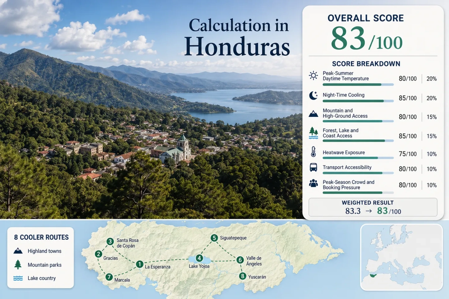
Honduras for Cooler Inland Travel: Mountain Parks, Lake Country and Highland Towns
Honduras cools unevenly inland. High towns such as La Esperanza, Santa Rosa de Copán and Valle de Ángeles provide relief at lodging level; Gracias and Lake Yojoa depend more on climbing into mountain forest. January–February combines cooler nights with lower rainfall. The altitude of the overnight base matters more than the highest point on a map: Celaque’s 2,849-metre summit rises over a warmer town, while the Yojoa lakeshore remains humid beneath cooler cloud forest.
January–February Base Median
25.4°C / 14.2°C
Accommodation-base median daytime maximum and overnight minimum.
Highest Mountain Reference
Celaque · 2,849 m
The summit strengthens the Gracias route but does not represent town nights.
Cooling Patterns
3 distinct modes
All-day highland, night-led and altitude-dependent routes.
Lake-Country Base Proxy
28°C / 18°C
The lake base is warmer and more humid than upper forest.
Road-Sensitivity Window
May–November
Rain cools afternoons but weakens mountain-road reliability.
Highland Towns, Mountain Parks and the Yojoa Basin
Markers connect western uplands, the central corridor, Lake Yojoa and capital-area mountains. They are planning centres, not exact trailheads or parking points.
Marker positions are approximate public location centres. Use the route cards for Google Maps searches and current access checks.
Honduras Inland Cooler Escape Suitability Score
This transparent editorial suitability index uses disclosed climate, landscape, access and pressure factors. It is not an official climate classification or a weather forecast. The score represents the eight mapped routes rather than the national average.
83out of 100
Calculated from 7 disclosed factors
Target windowJanuary–February
Climate baseline1980–2016 proxy climatology; official 2014–2018 cross-check
Heatwave periodRoute-level threshold proxy; no observed frequency claim
Routes assessed8 routes
MethodologyVersion 1.2
Last reviewedJuly 30, 2026
Factor coverage7/7
Comparability qualityC — route proxies and mixed record periods
Peak-Summer Daytime Temperature25%
71/100
Method: January–February monthly-high aggregation followed by the route median.Raw: 25.4°C median; normalized score 71.Route values: La Esperanza–Intibucá–Yamaranguila 22.0°C; Gracias–Celaque 26.4°C; Santa Rosa de Copán–Cerro Azul Copán 23.6°C; Lago de Yojoa–Peña Blanca–Cerro Azul Meámbar 28.0°C (Santa Cruz de Yojoa proxy); Siguatepeque–Montaña de Comayagua 25.3°C; Valle de Ángeles–Santa Lucía–La Tigra 23.6°C; Marcala–Opalaca–Montecillos 25.5°C; Yuscarán–Monserrat 26.4°C.Source mapping: Town-level Proxy Dataset pages; station codes are not published. Upper-park elevations remain separate from town temperatures.Period: 1980–2016 proxy climatology; INE 2014–2018 cross-check.Sources:La Esperanza; Gracias; Santa Rosa; Yojoa proxy; INE bulletin.
Night-Time Cooling20%
100/100
Method: January–February monthly-low aggregation followed by the route median.Raw: 14.2°C median; normalized score 100.Route values: La Esperanza–Intibucá–Yamaranguila 10.0°C; Gracias–Celaque 16.1°C; Santa Rosa de Copán–Cerro Azul Copán 14.4°C; Lago de Yojoa–Peña Blanca–Cerro Azul Meámbar 18.0°C (Santa Cruz de Yojoa proxy); Siguatepeque–Montaña de Comayagua 13.9°C; Valle de Ángeles–Santa Lucía–La Tigra 12.2°C; Marcala–Opalaca–Montecillos 13.0°C; Yuscarán–Monserrat 15.3°C.Source mapping: Town-level Proxy Dataset pages; station codes are not published. The Yojoa value represents basin lodging, not upper PANACAM forest.Period: 1980–2016 proxy climatology.Sources:Siguatepeque; Valle de Ángeles; Marcala; Yuscarán; INE bulletin.
Mountain and High-Ground Access15%
100/100
Method: Fixed altitude-access rubric; route-score median.Raw: Median 100.Route scores: La Esperanza–Intibucá–Yamaranguila 100 (base at 900 m or higher); Gracias–Celaque 100 (Celaque high ground); Santa Rosa de Copán–Cerro Azul Copán 100 (highland base); Lago de Yojoa–Peña Blanca–Cerro Azul Meámbar 100 (Meámbar high ground); Siguatepeque–Montaña de Comayagua 100 (highland base); Valle de Ángeles–Santa Lucía–La Tigra 100 (high towns and park); Marcala–Opalaca–Montecillos 100 (highland base); Yuscarán–Monserrat 100 (highland base).Route rationale: Each route meets the 900-m base or regularly accessible 1,500-m high-ground condition.Period: Access reviewed July 30, 2026.Sources:ICF western region; Visit Honduras nature areas; ICF La Tigra.
Forest, Lake and Coast Access15%
75/100
Method: Fixed physical-access rubric; route-score median.Raw: Median 75.Route scores: La Esperanza–Intibucá–Yamaranguila 75 (upland forest); Gracias–Celaque 75 (Celaque forest); Santa Rosa de Copán–Cerro Azul Copán 75 (park forest); Lago de Yojoa–Peña Blanca–Cerro Azul Meámbar 100 (lake plus cloud forest); Siguatepeque–Montaña de Comayagua 75 (mountain forest); Valle de Ángeles–Santa Lucía–La Tigra 75 (La Tigra forest); Marcala–Opalaca–Montecillos 75 (upland forest); Yuscarán–Monserrat 75 (mountain forest).Route rationale: Yojoa supplies two strong elements within the route; the remaining routes supply one strong forest element.Period: Access reviewed July 30, 2026.Sources:Honduras Travel nature areas; Visit Honduras nature areas.
Heatwave Exposure10%
75/100
Method: Conservative threshold-class proxy; not an exact daily exceedance count.Raw: Route-score median 75.Route scores: La Esperanza–Intibucá–Yamaranguila 100; Gracias–Celaque 75; Santa Rosa de Copán–Cerro Azul Copán 90; Lago de Yojoa–Peña Blanca–Cerro Azul Meámbar 55 (Santa Cruz de Yojoa proxy); Siguatepeque–Montaña de Comayagua 75; Valle de Ángeles–Santa Lucía–La Tigra 90; Marcala–Opalaca–Montecillos 75; Yuscarán–Monserrat 75.Source mapping: Long-term route upper-temperature ranges were assigned conservatively to fixed threshold classes; daily coverage and an observed 30°C frequency are not claimed.Period: 1980–2016 proxy ranges; comparability quality C.Sources:INE climatology resources; La Esperanza climate record; Yojoa proxy record.
Transport Accessibility10%
70/100
Method: Fixed transport rubric; route-score median.Raw: Median 70.Route scores: La Esperanza–Intibucá–Yamaranguila 60 (regional road journey); Gracias–Celaque 60 (town plus park transfer); Santa Rosa de Copán–Cerro Azul Copán 80 (western road base); Lago de Yojoa–Peña Blanca–Cerro Azul Meámbar 80 (main corridor plus local transfer); Siguatepeque–Montaña de Comayagua 80 (central corridor); Valle de Ángeles–Santa Lucía–La Tigra 80 (capital-area access); Marcala–Opalaca–Montecillos 60 (car useful beyond town); Yuscarán–Monserrat 60 (smaller regional connection).Route rationale: Town access and final mountain access were scored separately.Period: Reviewed July 30, 2026.Sources:Honduras road-condition advisory; Honduras inland access information.
Peak-Season Crowd and Booking Pressure5%
80/100
Method: Official tourism-supply and weekend-pressure proxy; route-score median.Raw: Median 80.Route scores: La Esperanza–Intibucá–Yamaranguila 80 (weekend demand); Gracias–Celaque 80 (park demand); Santa Rosa de Copán–Cerro Azul Copán 80 (broader lodging supply); Lago de Yojoa–Peña Blanca–Cerro Azul Meámbar 60 (concentrated lake corridor); Siguatepeque–Montaña de Comayagua 80 (transit demand); Valle de Ángeles–Santa Lucía–La Tigra 60 (capital weekend pressure); Marcala–Opalaca–Montecillos 100 (low concentration); Yuscarán–Monserrat 100 (low concentration).Route rationale: Registered lodging supply is a capacity proxy, not an occupancy count.Period: March 2025 inventory; reviewed July 30, 2026.Sources:IHT tourism-establishment report.
Method: Route count adds no bonus. Route-level values are combined with the median before the seven fixed weights are applied. Proxy limitations are reflected in comparability quality C.
Eight Inland Routes with Different Cooling Patterns
High-town routes cool the overnight base; park routes require an ascent; lake country remains warmer and more humid at lodging level.
1
La Esperanza–Intibucá–Yamaranguila
All-day highlandCool nightsTown-based
At roughly 1,700 metres, La Esperanza and Intibucá average about 22°C by day and 10°C at night in January–February. Cooling begins at the lodging base without a park ascent; Yamaranguila extends the route into rural highland terrain.
Cold mornings and unheated rooms may matter more than afternoon heat.
Gracias averages a warmer 26.4°C / 16.1°C in January–February. Cooling strengthens through Celaque’s forest and elevation, culminating at 2,849 metres; the summit climate does not represent hotels in town.
Main caution: Stronger cooling requires hiking; a night in Gracias is not a high-camp night.
Santa Rosa de Copán combines a highland city base with broader lodging capacity. Its January–February proxy is 23.6°C / 14.4°C; the official 2014–2018 station bulletin also places annual average maximums in the mid-20s Celsius. Cerro Azul Copán adds nearby forest terrain.
The lake-country base proxy is 28°C / 18°C in January–February, with roughly 12 muggy February days. Peña Blanca and Cerro Azul Meámbar matter because they shift the route from the humid basin into shaded, higher forest.
Why it stands out: Lake and cloud forest share one corridor; the slopes provide stronger relief.
Siguatepeque sits on the central travel axis and averages about 25.3°C / 13.9°C in January–February. It works as a low-detour overnight base; Montaña de Comayagua adds forested high ground for a longer stay.
Valle de Ángeles averages about 23.6°C / 12.2°C in January–February. Santa Lucía adds a second highland base and La Tigra adds forested walking terrain, but capital proximity increases weekend traffic.
Weekdays reduce traffic; verify La Tigra access separately from city weather.
Marcala averages approximately 25.5°C / 13.0°C in January–February. Coffee slopes and the Opalaca–Montecillos highlands create a distributed upland route, while low January rainfall improves the seasonal fit for rural roads.
Confirm lodging and the final rural road before departure.
Yuscarán averages near 26.4°C / 15.3°C in January–February. It offers a smaller highland base beside Monserrat terrain, with lower visitor concentration than Valle de Ángeles and a drier, less muggy February pattern.
Limited lodging makes advance confirmation useful.