Panama Highland Escapes: Boquete Trails, Chiriquí Peaks and Coffee-Country Air
Chiriquí’s cooler route is not a single town. It is a rising sequence from Boquete’s serviced valley to Bajo Mono cloud forest, Jaramillo coffee slopes, the Volcán–Bambito corridor and Cerro Punta’s agricultural high country, with Volcán Barú forming the colder, more exposed ceiling. In July and August, elevation keeps daytime conditions historically milder than Panama’s lowlands, while frequent cloud, wet trails and afternoon rain make route choice as important as temperature.
Town bases, coffee ridges, cloud-forest approaches and one high-exposure summit route are assessed with equal route weight.
Volcán Barú is Panama’s highest point; summit conditions should never be inferred from a mild evening in Boquete.
The route-set median uses published gridded climatology proxies rather than a single lowland weather station.
Upper Tierras Altas and forest approaches provide the clearest overnight cooling, with damp air often increasing the chill.
The corridor links the Boquete and Cerro Punta sides of Barú, but current trail extent and access status require verification.
Morning starts, covered activities and a dry backup day matter more than squeezing several long hikes into one itinerary.
Boquete Valley, Barú Slopes and the Tierras Altas Corridor
The route set follows both sides of Volcán Barú rather than treating Boquete and Cerro Punta as neighboring stops on one short ridge road. Markers show public planning centers, not guaranteed trailheads, legal parking spaces or exact viewpoints.
Use the named Google Maps links in the destination entries for road orientation. Protected-area entry, trail status, private-farm access and legal parking must be checked separately before travel.
Chiriquí Highland Cooler Escape Suitability Score
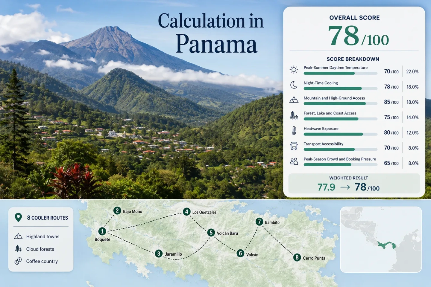
This transparent editorial suitability index uses disclosed climate, landscape, access and pressure factors. It is not an official climate classification or a weather forecast. Climate inputs rely partly on route-center and nearest-elevation gridded proxies, so the comparability grade is C.
Weighted total: 95×0.25 + 100×0.20 + 100×0.15 + 88×0.15 + 96×0.10 + 70×0.10 + 60×0.05 = 91.6 → 92/100
Method: Route count adds no bonus. The eight route-level values carry equal weight inside each factor, the route median is normalized, and the seven fixed weights are then applied.
Boquete Trails, Coffee Ridges and Tierras Altas Bases
The eight areas serve different cooling needs. Boquete carries the strongest car-light town infrastructure; Bajo Mono and Los Quetzales shift the emphasis to wet forest; Jaramillo adds working coffee slopes; Volcán, Bambito and Cerro Punta provide stronger night cooling; Barú requires a separate exposure and access plan.
Boquete: Serviced Valley Base Below Barú
Boquete sits around the 1,200 m elevation band and combines a historically mild July–August proxy of roughly 22.2°C by day and 16.5°C at night with restaurants, accommodation and regular road connections from David. The town works for a low-friction cooling break, but the center is less forested and less cold at night than upper Tierras Altas.
David is about 50 minutes away by road in official destination planning information. Local taxis or arranged transfers are still useful for trail corridors outside the center.
Bajo Mono: Waterfall Air and Shaded Upper Valley
The road above Boquete enters a wetter, narrower landscape where cloud forest, river channels and waterfall approaches reduce direct sun. The planning proxy is about 22.0°C maximum and 16.0°C minimum in July–August, but wet clothing and wind after rain can make the upper valley feel colder than the numbers suggest.
Jaramillo: Coffee Ridges Above the Caldera Valley
Jaramillo is less about one public trail and more about a chain of ridges, farms and private roads above Boquete. A July–August proxy near 22.4°C by day and 16.2°C at night is paired with greater exposure to mist and breeze than the town center. Visits should be arranged with farms rather than treating cultivated slopes as open public land.
Works for: Travelers who want coffee production, slope ecology and a shorter walking day instead of a full cloud-forest crossing.
Los Quetzales: A Two-Sided Cloud-Forest Crossing
The protected corridor links the Boquete side of Barú with Cerro Punta. Its upper-route proxy is roughly 21.0°C by day and 14.2°C at night, with dense shade and wet ground producing a stronger cooling effect than exposed town streets.
Quetzal sightings are possible but never guaranteed; trail value comes from the cloud-forest system even without a sighting.
Volcán Barú: Cold Exposure Above a Tropical Country
Barú rises to 3,474 m, but the score uses a practical approach-zone proxy of about 21.0°C maximum and 13.0°C minimum rather than pretending that summit weather represents accommodation conditions. Official tourism information describes the Boquete route as the longer, less-steep approach and the Los Llanos side as shorter but more demanding.
Official 2025 notices stressed registration, changing weather, appropriate footwear and the 12–13 km Camiseta-to-summit approach. Road rehabilitation and operator controls mean vehicle access should be treated as current-status information, not a permanent entitlement.
Volcán: Practical Western Base for Tierras Altas
Volcán provides shops, buses and a broader local town environment on the western side of Barú. The July–August planning proxy is about 23.2°C maximum and 15.5°C minimum. It is slightly warmer by day than Bambito or Cerro Punta, yet more practical for travelers who need transport choices and food services.
The town is reached through David and serves as the road hinge for Bambito, Cerro Punta, Paso Ancho and the Los Llanos side of Barú.
Bambito: River-Valley Lodges and Cooler Nights
Bambito occupies the road corridor between Volcán and Cerro Punta, with river proximity, forest edges and a higher lodging profile. Its proxy sits near 22.0°C by day and 14.9°C at night. It is a useful compromise when Cerro Punta feels too remote but Volcán town feels too built-up.
Road access is straightforward along the Tierras Altas axis, while individual lodges may still be difficult to reach on foot after dark or during heavy rain.
Cerro Punta: Agricultural High Country Near the Cloud Forest
Cerro Punta and nearby Guadalupe sit in the upper farming zone of Tierras Altas, where greenhouses, vegetable fields, rivers and protected-forest approaches share a compact valley. The planning proxy is about 21.4°C maximum and 13.8°C minimum in July–August.
Official destination information places Cerro Punta roughly 1.5 hours from David and about 1.5 hours by road from Boquete. The apparent map distance is shortened by the volcano; the actual route bends around Barú rather than crossing directly over it.
Barú Separates Boquete from Tierras Altas
Boquete, Volcán and Cerro Punta appear close on a small map because all sit around the same volcanic massif. Ordinary road travel does not cut across the protected summit. The practical connection loops around Barú through lower road corridors, creating distinct eastern and western travel bases.
Boquete Side
Boquete is the easier base for restaurants, coffee tours, Bajo Mono and the longer summit approach. David–Boquete is usually the shorter airport-to-highland transfer.
Volcán and Bambito Side
Volcán is the transport hinge for western Barú, Paso Ancho and Bambito. It carries more everyday services than Cerro Punta while retaining strong overnight cooling.
Cerro Punta Side
Cerro Punta favors agricultural landscapes, upper-valley nights and western access to cloud forest. A one-night add-on from Boquete wastes more road time than a dedicated two- or three-night western stay.
Why Los Quetzales Has More Than One Published Distance
Los Quetzales is described through different operational units. A MiAmbiente reopening notice identified a rehabilitated 6.5 km moderate trail, while 2026 official tourism material describes a longer corridor from Bajo Mono toward Cerro Punta, including a partial viewpoint option and an end-to-end route. These figures can refer to different open segments, access points or itinerary definitions rather than one universal trail measurement.
Partial Forest Day
Starting from the Boquete side and turning back before the full crossing reduces transport complexity. It still requires a current status check because heavy rain, maintenance or fallen trees can alter the usable segment.
End-to-End Crossing
A full crossing needs a confirmed exit, arranged pickup or a luggage-transfer plan. Adding another demanding hike on the same day is poor route design, especially in the green season.
July–August Cooling Comes with Green-Season Trade-Offs
July and August suit travelers escaping hotter lowland conditions, but they are not the clearest or driest highland months. Cloud and rain support the cooler feel while reducing summit visibility and increasing mud on forest trails.
Early Morning
Use the first part of the day for exposed viewpoints, coffee-ridge walks and routes where visibility matters. Wet foliage and cool starts still require traction and a light layer.
Afternoon Rain Window
Move tastings, covered farm visits and town activities into the afternoon. A shower can be brief, but saturated ground and rising streams remain after rain stops.
Clearer Trail Alternative
January and February generally align more closely with drier access, clearer summit attempts and active coffee-processing visits. They solve a different problem from a July–August heat escape.
Rain is not a separate score factor. It changes comfort, route reliability and equipment needs, but the site-wide score keeps the same seven factors for comparability.
Coffee-Country Air Is a Landscape, Not Only a Tasting
The Boquete and Tierras Altas coffee circuit occupies elevated, sloping land where shade trees, cloud movement, drainage and exposure vary over short distances. Jaramillo emphasizes accessible farm visits near Boquete; Volcán and the Tierras Altas side place coffee within a broader agricultural district; upper farms can sit much higher than the nearest town center.
Farm-Slope Walk
Choose a visit that includes the cultivated slope, shade system and processing area. A tasting room alone does not show why one ridge feels wetter or cooler than another.
Harvest Timing
July–August is useful for green highland scenery, not for assuming every farm is in peak harvest. Farm activity and public tour schedules should be checked directly.
Private Working Land
Coffee plantations are businesses and homes, not open hiking terrain. Reservations, footwear rules, photography limits and road access differ by farm.
Eight Highland Areas Compared by Cooling Role and Access
All routes used in the map and score appear in the same decision matrix. Temperature values are planning proxies and should not replace a current local forecast.
| Area | July–August proxy | Primary cooling mechanism | Access pattern | Rain trade-off | Useful role |
|---|---|---|---|---|---|
| Boquete | 22.2°C / 16.5°C | Valley elevation and night cooling | Regular bus and strong town services | Center remains easier than forest approaches | Low-friction highland base |
| Bajo Mono | 22.0°C / 16.0°C | Shade, streams and cloud forest | Local transfer from Boquete | High mud and waterfall-route sensitivity | Shorter forest and water day |
| Jaramillo | 22.4°C / 16.2°C | Elevated coffee ridges and breeze | Taxi, tour or car is practical | Private-road and farm-schedule limits | Coffee landscape without a long trek |
| Los Quetzales | 21.0°C / 14.2°C | High cloud forest | Two-sided trail logistics | Closures and segment changes after rain | Full forest immersion |
| Volcán Barú | 21.0°C / 13.0°C approach proxy | Extreme elevation and exposure | Registration, reservation and specialist transport | Visibility, cold and route-work constraints | Serious summit objective |
| Volcán | 23.2°C / 15.5°C | Highland town and open foothill air | Regular connection through David | Less forest shade in town | Practical western base |
| Bambito | 22.0°C / 14.9°C | River valley, forest edge and elevation | Main road access; car useful locally | Wet lodge approaches after dark | Quiet lodge-centered stay |
| Cerro Punta | 21.4°C / 13.8°C | Upper-valley altitude and night cooling | Bus or car through Volcán | Cloud and rain affect forest access | Agricultural high-country base |