Guatemala Highland Coolcation: Lake Atitlán, Volcano Towns and Cloud-Forest Air
Guatemala’s highlands replace lowland heat with three distinct comfort systems: Lake Atitlán’s moderated shore air, colder nights in volcanic towns above 1,500 metres, and the shaded but moisture-heavy air of the Verapaces cloud forests. July and August remain rainy months, so elevation alone does not settle the route choice. Boat timing, saturated roads, volcanic advisories and the difference between dry-cool and wet-cool air change how each base works.
Three Lake Atitlán circuits, three volcanic-town routes and two Verapaces cloud-forest routes.
Each system lowers heat differently; humidity and transport exposure remain separate planning issues.
Tecpán–Patzún July–August mean daily maximum at the representative planning cell.
Quetzaltenango–Zunil July–August mean daily minimum at the selected highland cell.
Quetzaltenango–Zunil two-month grid total; afternoon rain still remains part of the route.
The cooling wind can also produce rougher crossings, making morning boat movement more reliable.
Atitlán Shores, Volcanic Towns and Verapaces Cloud Forests
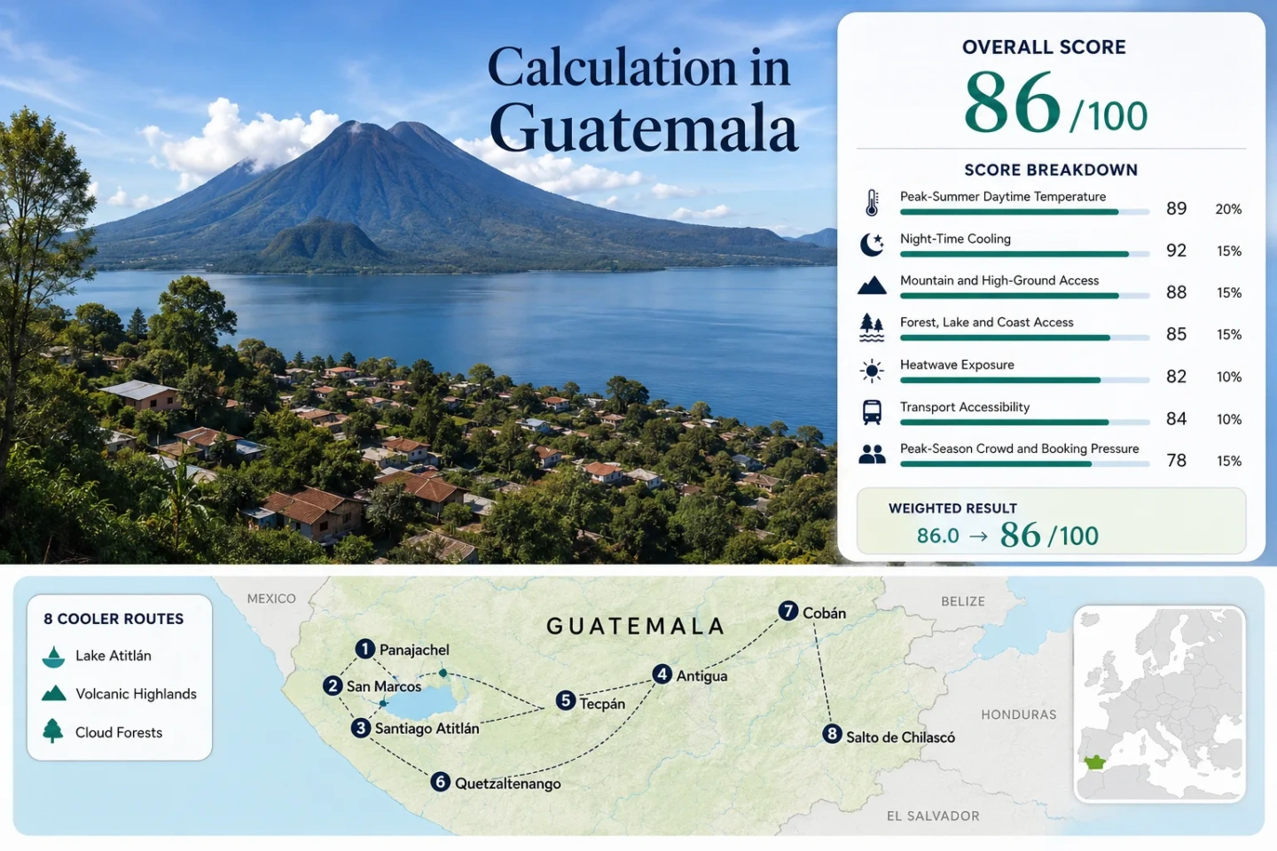
The eight markers follow the same route portfolio used in the suitability score and comparison table. Lake routes cluster around Atitlán, western routes rise into the central and Quetzaltenango highlands, and the eastern pair enters the wetter Verapaces corridor.
Markers show selected cooler-route regions and approximate public planning centres, not guaranteed legal parking, trailheads or exact viewpoints. Route cards provide Google Maps searches and access context.
Guatemala Highland Cooler Escape Suitability Score
This transparent editorial suitability index uses disclosed climate, landscape, access and pressure factors. It is not an official climate classification or a weather forecast. The score represents the eight routes on this page rather than Guatemala as a whole.
Weighted total: 81×0.25 + 100×0.20 + 100×0.15 + 75×0.15 + 90×0.10 + 60×0.10 + 80×0.05 = 85.5 → 86/100
Method: Route count does not add bonus points. Route-level values or category scores are combined using the median before the fixed weights are applied. Climate figures are gridded planning values, not lodging-level forecasts.
Lake Shores, Volcanic Plateaus and Mist-Belt Bases
Every route stays above the 900-metre high-ground threshold, yet their daily rhythm differs. Lake routes depend on crossing conditions, volcanic towns gain more after-dark cooling, and Verapaces routes exchange direct sun for humidity and rain-sensitive access.
Panajachel–Santa Catarina Palopó
Panajachel provides the most flexible Atitlán base because road arrivals, accommodation and public boats meet in one place. Santa Catarina Palopó adds a steeper lakeside setting without committing the entire stay to boat-only movement. The representative July–August grid records a 24.5°C mean maximum, a 13.5°C mean minimum and 573 mm across the two months.
The cooling breeze becomes a transport trade-off after midday. Morning crossings normally provide a calmer planning window; late returns need time flexibility when Xocomil winds strengthen.
San Marcos–San Juan La Laguna
Planning cell: 1,569 m, with a July–August mean maximum of 24.5°C, mean minimum of 13.5°C and 547 mm of rain. The numbers resemble Panajachel, but the access pattern does not.
San Marcos works as a compact waterfront base, while San Juan spreads movement across steeper streets and artisan areas. Public boats keep both connected to Panajachel, yet the route becomes less resilient when a return is fixed late in the day. A road alternative exists, though it is slower and winding.
Santiago Atitlán–San Lucas Tolimán
The south-shore representative cell sits near 1,608 m and averages 24.3°C by day and 13.2°C at night in July–August. Its two-month rainfall total reaches 582 mm, the highest value in the eight-route climate grid.
Santiago combines a dense town centre with lake transport; San Lucas Tolimán adds a stronger road connection on the southeastern shore. The route lies beneath the Atitlán–Tolimán volcanic complex, where ravines and drainage channels matter after intense rain. Lake proximity does not remove slope risk.
Antigua–San Juan del Obispo
Antigua has the strongest car-light and shuttle logic in the portfolio. San Juan del Obispo shifts the same basin toward the lower slopes of Volcán de Agua, where evenings are quieter and the urban heat stored by paving and walls is less dominant.
The route is drier in the grid than the Atitlán and Verapaces circuits, but it carries a different operational risk. Fuego ash movement depends on activity and wind direction. On July 20, 2026, INSIVUMEH reported a west–southwest ash cloud linked to recurring activity rather than a new eruptive increase. That dated event should not be treated as a permanent closure, yet a same-day bulletin check remains sensible.
Tecpán–Patzún Highlands
Lowest daytime grid in the set: 19.6°C mean maximum. The representative 2,319 m cell also falls to a 9.0°C mean minimum, while July–August rainfall totals 554 mm.
This is a road-based plateau route rather than a tourism-centred lake circuit. Pine-covered uplands, open agricultural ground and exposed roads increase the after-dark temperature drop. Light summer clothing alone is poorly matched to early mornings here.
Quetzaltenango–Zunil–Fuentes Georginas
Quetzaltenango supplies the urban base; Zunil and Fuentes Georginas move into wetter volcanic slopes and cloudier forest. The route records the strongest night cooling and the lowest July–August rainfall total in the selected grid, 319 mm. That does not make Fuentes Georginas dry: local orographic cloud and wet roads remain common even when the broader cell is less rainy than Atitlán.
Intercity buses reach Xela without a car. The final climb toward the geothermal pools needs a shuttle, taxi or arranged vehicle, and dense fog can make a short distance take longer than expected.
Open Quetzaltenango, Zunil and Fuentes Georginas in Google Maps
Cobán–San Pedro Carchá
The 1,330 m representative cell is warmer than the western plateaus: 25.8°C mean maximum and 14.1°C mean minimum in July–August. A 559 mm two-month rainfall total and frequent cloud make the air less sun-loaded but more humid.
Cobán offers the stronger accommodation and transport base. San Pedro Carchá moves closer to rural approaches where rainfall has a larger effect on local roads. On July 16, 2026, INSIVUMEH identified upper-soil saturation of at least 90% in San Pedro Carchá and five other Alta Verapaz municipalities. The alert was event-specific, but it shows why route checks must include ground conditions rather than rainfall probability alone.
Biotopo del Quetzal–Salto de Chilascó
Cloud-forest profile: 1,707 m representative elevation, 21.8°C mean maximum, 13.7°C mean minimum and 504 mm across July and August.
Forest canopy and mist reduce direct solar load more effectively than the exposed Atitlán waterfront. The cost is moisture. Trails remain slick, clothing dries slowly, and a waterfall approach can become less practical after several wet days even when the air temperature is low.
Open Biotopo del Quetzal and Salto de Chilascó in Google Maps
Which Highland System Matches the Trip?
The same temperature can produce a different travel day. A lake breeze may interrupt a crossing, a 9°C plateau night may require warmer sleep layers, and a 22°C cloud forest can still feel heavy when everything remains damp.
| Route | Cooling signature | July–August max / min | Two-month rain grid | Access pattern | Main planning constraint |
|---|---|---|---|---|---|
| Panajachel–Santa Catarina Palopó | Lake moderation and breeze | 24.5°C / 13.5°C | 573 mm | Road base with public boats | Afternoon wind and weekend pressure |
| San Marcos–San Juan La Laguna | West-shore lake air | 24.5°C / 13.5°C | 547 mm | Boat-led with winding road backup | Late return flexibility |
| Santiago Atitlán–San Lucas Tolimán | Lake air beneath volcanic slopes | 24.3°C / 13.2°C | 582 mm | Boat and road split | Lahar channels and heavy-rain drainage |
| Antigua–San Juan del Obispo | Volcanic-basin night cooling | 24.3°C / 14.2°C | 365 mm | Direct road and shuttle access | Ash direction and urban crowding |
| Tecpán–Patzún Highlands | Exposed high plateau | 19.6°C / 9.0°C | 554 mm | Road-based interurban route | Cold wet evenings and low cloud |
| Quetzaltenango–Zunil–Fuentes Georginas | High city plus misty volcanic slope | 20.5°C / 8.5°C | 319 mm | Bus to Xela, arranged final climb | Fog and last-segment transport |
| Cobán–San Pedro Carchá | Humid upland cloud cover | 25.8°C / 14.1°C | 559 mm | Regional road base | Ground saturation and moisture load |
| Biotopo del Quetzal–Salto de Chilascó | Canopy shade and persistent mist | 21.8°C / 13.7°C | 504 mm | Car or arranged local transfer | Wet trails and daylight limits |
Temperature, rainfall and elevation figures use representative grid cells at approximate planning centres. Multi-stop routes cross local elevation and exposure changes, so values describe route character rather than every hotel, dock or trail.
Lake Atitlán Changes by Hour, Not Only by Month
Atitlán’s lake air creates a daily operating clock. The same wind that lowers the apparent heat can make open-water travel less comfortable later in the day.
Early Crossings
Morning usually offers the calmer crossing window. Moving from Panajachel to San Marcos, San Juan or Santiago early leaves more room for weather changes and reduces dependence on a fixed late return.
Midday Shore Heating
Sun-exposed docks and stone streets warm faster than shaded waterfront paths. Santa Catarina Palopó and the steeper west-shore towns also create short but demanding climbs even when the wider air temperature remains moderate.
Afternoon Xocomil
The local Xocomil circulation commonly strengthens later in the day. It adds cooling over the water but can increase chop. A route that requires two afternoon crossings has less operational margin than a route returning on foot or by road.
Evening Base Choice
Staying in the town used for the final afternoon activity removes the need to race a changing lake. Panajachel has the strongest road fallback; west-shore villages offer a quieter night but fewer simple alternatives when boats become uncomfortable.
Ash West of Fuego, Saturated Ground in the Verapaces
Volcanic and cloud-forest routes need different checks. Antigua’s practical question is often wind direction during Fuego ash events. The Verapaces question is cumulative rain: soil and small-road conditions can remain poor after the heaviest precipitation has ended.
Antigua and the Fuego Wind Sector
INSIVUMEH reported gas and ash moving west and southwest on July 20, 2026, with possible ashfall around San Pedro Yepocapa. The notice described recurrent activity rather than a new increase. Antigua was not presented as universally closed; the useful decision is whether the day’s wind places a planned road or outdoor activity downwind.
Same-day check: Fuego bulletin, ash-dispersion map and road visibility.
Cobán, Carchá and Wet-Ground Persistence
On July 16, 2026, six Alta Verapaz municipalities recorded at least 90% saturation in the upper 30 cm of soil; San Pedro Carchá was among them, and a departmental Orange Alert was active. A later reduction in rainfall does not immediately reset slopes, drainage or unpaved approaches.
Same-day check: Soil saturation, local road reports and daylight remaining for the return.
The 2026 Canícula Did Not Create One Highland Rain Pattern
INSIVUMEH expected the 2026 canícula, a temporary reduction in rainfall, between mid-June and early July with regional variation. The July outlook then placed lower monthly totals over Occidente and the Altiplano Central while the Franja Transversal del Norte remained among the wetter zones. The practical split is visible between Xela or Antigua and the Cobán corridor.
Occidente and the Altiplano Central
July 2026 mean temperatures were forecast in the 14–22°C range, with average maxima of 18–30°C across the broad regions. Rainfall deficits did not remove afternoon storms, but they could create more usable road and walking windows than in the northern wet belt.
Lake Atitlán
A rain break does not stop Xocomil wind or erase drainage risk below volcanic slopes. Morning boat use and a same-town afternoon plan remain more dependable than assuming a nationally advertised canícula means calm water all day.
Verapaces and the Northern Wet Belt
The July outlook allowed much larger monthly totals in the Franja Transversal del Norte than in the western highlands. Cobán and Chilascó therefore need a separate rain decision, even when Antigua or Xela has entered a drier spell.
July–August route logic: Use Quetzaltenango or Tecpán for the deepest night cooling, Atitlán for lake-moderated days with flexible boat timing, and the Verapaces for canopy shade only when moisture and road sensitivity fit the trip.